|
| Front page | | Contents | | Previous | | Next |
Adapting to the Climate of the Future
Example 1 Urban areas and the open country
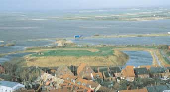
The town Løgstør will no longer be taken by surprise by weather and climate. Situated in Jutland, at the north-western bank of the fjord Limfjorden, Løgstør is one of the towns in
Denmark that, for the last 25 years, have faced frequent storm surges and episodes of high sea levels. According to the Løgstør municipal contingency plan, the worst storm surge
incidence ever experienced was in 1981. Streets were flooded, and buildings and installations were severely damaged. At that time people were not prepared to deal with such extreme
forces of nature.
The storm surge incident at Løgstør triggered the establishment of the contingency plan used today – and the first measures were taken to secure exposed buildings, transmission lines,
technical installations and sewers. Large sums have been spent on maintenance and renewal of the waterfront and raising the road along the harbour. Investments are, however,
worthwhile – not least in the light of the changed climate in the future.
Several other towns in Denmark that otherwise do not have to deal with these kinds of problem every day may face a similar situation in the future.
Table 2
Facts about extreme storm surge Examples of high waters at inland coasts
and in the Wadden Sea, sea rises in centimetres.
| Average time between incidents |
1 yr |
20 yrs |
50 yrs |
100 yrs |
Inland coastlines (Randers)
Wadden Sea (Højer Sluice) |
105
288 |
155
418 |
168
448 |
178
469 |
Source: Danish Coastal Authority, 2002, in the Academy of Technical Sciences' background report, 2003
The table shows the average time between recurrence of the water levels indicated, in current climate conditions, for instance extreme high water of 4.18 m occurs every 20 years at
Højer Sluice. With a future sea-level rise of for instance 50 cm, the storm surge will reach 4.68 m every 20 years, if the wind climate does not change. This corresponds to extreme
storm surge (4.69 m in the right-hand column), which, today, only occurs once in one hundred years. However, since the wind conditions will also change, the incident that will currently
take place once in a hundred years in the Wadden Sea will occur at 5-15 year intervals if the sea level rises 50 cm.
Many Danish towns are located at fjords or mouths of rivers. In step with the sea-level rise resulting from global climate change, the risk of storm surge etc. will surely affect not only towns at westerly coasts, but, generally, many other towns located near the
water.
The rising sea level will affect beach feeding and the construction of dikes, it will cause problems of rising groundwater levels and of salt water intrusion in the groundwater zone in
low-lying areas and on small islands.
Regional planning with an extra dimension
Climate change will not only affect many towns located at the sea, but will also influence overall spatial planning in the open country. Therefore a sensible thing for regional planners to do
is to consider the consequences of sea-level rise and frequent storms for the use of land in their area, and also to consider how a warmer climate with more precipitation will influence the
development in the power plant sector and the capacity of sewage treatment plants.
Facts about the water level in Denmark
- Today: The water level is monitored continuously by the DMI, the Danish Coastal Authority and the Royal Danish Administration of Navigation and Hydrography. In the past century
the water level increased by 10-13 cm in south-western Denmark, and fell 1-2 cm at Skagen. Assuming that the water level around Denmark has increased by 15 cm in the last 100
years – corresponding to the global average – an uplift of Danish land must have taken place.
- ln the future: Even if the uplift of land continues, it is not sufficient to keep pace with the sea-level rise, which according to the UN Climate Panel's third assessment report 2001 is
expected to be in the order of 9-88 cm over the next century.
Regional planners typically take decisions on a number of cases of vital importance to development many years ahead. The latest regional plans cover the period up to 2013, but are
revised every four years. Therefore, we might start identifying the areas we wish to preserve, and the areas where possible changes can be accepted, in order not to allocate needless
resources to areas which may have to be abandoned in the longer term.
New challenges
By way of example, the anticipated climate change in Denmark may impair the profitability of new buildings at the coasts, unless account is taken of future sea-level rise. The lifetime of
buildings is typically a hundred years, and they must therefore be able to withstand new weather, wind and water conditions.
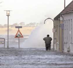
"Today the average time span between water level rises exceeding 150 cm is 100-200 years, but in 2100 they will occur every second year".
Academy of Technical Sciences' report on the Port of Copenhagen

Development of harbour areas for new purposes
Imagine the local authorities planning a new prestige construction project in a harbour area that is no longer used for traditional purposes. Everyone is excited, and the project is
completed. The problems, however, do not arise until the construction work is finished. Suddenly, after a major storm, we are faced with flooded basements and foundations, realising
that this will not be the only episode of this nature.
Many Danish towns include harbour areas that may be used for new purposes. Often they are attractively situated, and the new building projects are very expensive. Politicians,
planners, architects and engineers must therefore include sea-level rise in their long-term planning, in order not to end up with unprofitable buildings and lots of extra costs.
In spring 2003 the Danish Folketing adopted an amendment to the Spatial Planning Act, thus enhancing the scope for changing old harbour areas into new integrated urban areas of
houses and housing-compatible industry. The opportunities embedded in this Act underline the need to be very careful when planning the development of exposed harbour areas.
In other areas we may have to reconsider the use of a number of drained fields. Part of the Danish land is elevated seabed, lying low for instance in reclaimed areas. Can these areas be
used for agriculture also in the future? Or will the costs of continuing drainage become too big?
The local/regional authorities of the future might also have to view nature management in the light of new climate conditions. In a changed climate, some conflicts of interests may stand
out more clearly and present new challenges. But by including available knowledge on climate trends, it will be easier for us to make the right choices in due time.
| Front page | | Contents | | Previous | | Next | | Top |
Version 1.0 December 2004, © Danish Environmental Protection Agency
|