Nature & Environment 2004
Land use
Land use in Denmark has changed considerably over time and is still changing. Urban areas and road infrastructure have expanded at the cost of meadows, dunes, marshes, and lakes. Arable land still accounts for the greater part of the landscape, covering 62 per cent, but this share is diminishing.
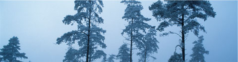
In many places today, forest is being established on former arable land, so that, now, a total of 11 per cent of Denmark is covered by forest.
The general trend
Viewed over a decade, land use in Denmark has changed radically. The area of built-up land has increased significantly, and the land area taken up by road infrastructure, arable land, and mineral resources exploitation has also increased. Land reclaim projects have drained almost 200,000 hectares of lakes, fjords, and wetlands. Today, arable use of these marginal land types is in decline and in many cases not financially feasible, e.g. because of the extra costs associated with continuous draining.
Our use of the land in Denmark is still subject to change. For example, we are establishing new forests and erecting new housing on former arable land. Furthermore, there is a continuing trend in terms of fewer but larger farms, and as the result of continued intensified cultivation, fields are becoming ever larger, reducing the number of e.g. field tracks, hedgerows, and small biotopes etc.
Agriculture
Denmark is very much a farm land today, as it was a hundred years ago. This is true even though the area of cultivated land has gone down from 74 per cent in 1920 to 62 per cent today.
The total number of farms in agriculture has fallen from 92,000 in 1985 to 46,500 in 2003. This development could be explained by three overall trends: intensification, specialisation, and concentration. Each trend contributes to changes in the landscape and nature. Danish farm landscapes are changing structurally as the number of farms falls and the size of the remaining farms increases. Via this concentration of arable land on few farms, a homogenisation of the landscape is taking place, as there is a significant correspondence between the size of the farm and the average size of the individual field.
Furthermore, during the last decade, a change from cattle to pigs has occurred in livestock farming. In 2003, Denmark produced 24.4 million pigs. In January 2004, the Danish pig stock totalled about 13 million; a 24-per-cent increase from 1990. The increase in the number of pigs over the last decade has happened primarily in western Jutland, whereas northern and western Zealand have seen a decrease. The number of cattle and sheep has decreased, and this decrease has been most significant in Jutland.
Livestock farms account for three-quarters of ammonia emissions from agriculture. Regional specialisation of agriculture production in Denmark and the subsequent differences in livestock density between Eastern and Western Denmark mean that nutrient-poor heaths in Western Jutland have become particularly threatened by over-fertilisation caused by ammonia emissions from manure. Heaths require nutrient-poor growth conditions and are therefore vulnerable to ammonia, which serves as a nutrient.
Overall a number of environmental impacts from agriculture have been reduced during the last decade, while at the same time agricultural production has been relatively stable, showing a slight fall over time. For example, energy consumption by agriculture has gone down, as has pesticide treatment frequency (number of sprays each year) and nitrogen input. Nitrogen leaching and runoff to watercourses and lakes over the last 10 to 15 years have been halved, amongst other things as a result of action plans for the aquatic environment, and ammonia volatilisation has been reduced by one third. However, impacts are still high.
Nature and forests
The proportion of natural area has fallen dramatically over the past 100 years. Open-land habitats such as meadows, dry grasslands, dunes, coastal meadows, heaths, marshes, and lakes covered almost 60 per cent of Denmark 200 years ago. Today, these habitats cover only about 10 per cent of Denmark. The area of forest reached a low point around 1800, where only about four per cent of forest in Denmark was left. However, since then the area of forest has been growing, reaching somewhere around 11 per cent in 2000. Today, in many places throughout Denmark forests are being established on former arable land.
Changes in land use
Many changes in land use in Denmark come from changes to existing arable land and forest.
Due to the storm in December 1999, large areas of forest were subject to windfalls. Areas with conifers, which are most vulnerable to storm damage, were hardest hit. Transition forest is a classification for young forests in growth and forests which have been degraded due to e.g. windfalls. A total of 6 per cent of the overall area of forest in 1990 had become transition forest in 2000.
A total of around 20,000 hectares of arable land have gone over to different land use. Of this 20,000 hectares, 10,000 hectares now fall under the categories of cities, commerce and industry, and sports and recreational areas, including areas with summerhouses. Even though these changes pertain only to 0.2 per cent of Denmark's total area, they nevertheless stress the general trend toward more housing at the cost of the open countryside.
More than 6,000 hectares of arable land have become transition forest, a change linked to afforestation efforts. Furthermore, 1,750 hectares of arable land have changed into wetlands and lakes, which is most likely due to wetland restoration efforts.
These figures are from the Corine Land Cover Inventory, based on interpretation of satellite imagery. Since the minimum size of areas registered in the Corine Inventory is 25 hectares, we primarily know of changes on the large, cohesive areas that have been registered. Changes on areas less than 25 hectares have therefore not been included and, consequently, the overall scope of changes in land use is probably underestimated in the Corine Inventory. Nevertheless, the figures imply general development trends which are supported by other statistics.
Source: National Environmental Research Institute (NERI), Miljøtilstandsrapport 2005 (The State of the Environment in Denmark 2005)
1 DISTRIBUTION OF AREA
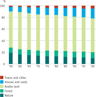
Source: Statistics Denmark
The graph shows developments in the area distribution between 1950-2000, broken down into five area types: nature, forest, farmland, houses and roads in the open countryside, and finally towns and cities.
The proportion of natural area has fallen dramatically over the past 250 years. Today, only 10 per cent of the area is covered by natural areas such as dunes, heaths, marshes, meadows, and lakes. Natural areas in this category are protected by legislation against further decline in area. The dramatic decline in the area of these types of natural habitat has thus been stopped. The objective is to curb the decline in biodiversity (i.e. the decline in the area as well as the quality of nature) by 2010.
The area of forest reached a low point around 1800, where only about four per cent of forest in Denmark was left. The area of forest has been increasing ever since and today constitutes almost 500,000 hectares, which is about 11 per cent of the total land area of Denmark. In 1989 a political decision was made that the area of Danish forests should be doubled in 80-100 years. The area of forest has been on the increase since 1989, but the increase is still not large enough to be apparent from the graph.
The area of arable land has been constant since 1950 and today takes up about 62 per cent of Denmark. Fields in Denmark take up more space in relation to the total area than any other country in Europe. Many wetlands have been drained in order to allow space for agriculture or forestry. Today, 80 per cent of the total land area of Denmark is affected by draining, and only four per cent of the country is covered by marshes, bogs, and water meadows. Many lakes and watercourses have also disappeared because of draining. The proportion of the land area taken up by roads and housing has increased significantly, not least since 1950. As the land area of Denmark is used more intensively than in other countries, efforts are being done to combine and integrate to a greater extent the different considerations in land use, including considerations for nature.
2 DRAINAGE
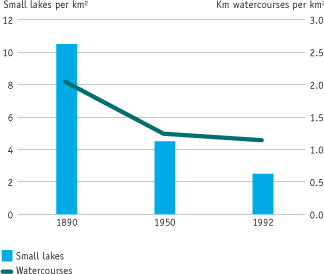
Source: Funen County
Many small lakes and watercourses have disappeared from the landscape as a result of draining. The bars show the development of the area around Lake Arreskovsø on Funen.
Over the past 100 years, the extent of open watercourses in Denmark has fallen dramatically because digging ditches and watercourses into pipes, and straightening watercourses, has made them shorter. For example, on the basis of old maps it has been calculated that the length of the watercourses in the catchment area for Hundstrup Å, a river in southern Funen, fell from about 174 kilometres in 1890 to about 97 kilometres in 1992.
Draining wetlands, etc. for cultivation has also had a great impact on the number and size of lakes and fjords on Funen. In the catchment area for Lake Arreskovsø the number of smaller lakes and waterholes has fallen from 276 to 65 over the past 100 years. This development has dramatically reduced the habitats for animals and plants.
Overall, a great number of wetlands have been drained to deliver land to agriculture or forestry, and land reclaim projects have thus laid dry almost 200,000 hectares lakes, fjords and other wetlands in Denmark. The natural interplay between watercourses and meadows, with periodical flooding of watercourses to fertilise meadows, now only occurs in very few places in Denmark. The Danish Protection of Nature Act from 1992 has stopped the direct draining of small lakes and marshes, and today farmers can only recover groundwater for watering fields.
3 SIZE OF FARMS AND FIELDS
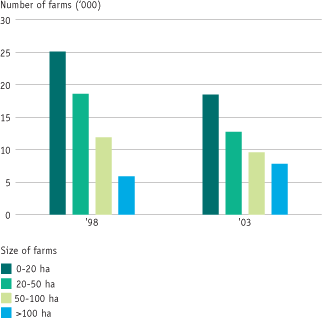
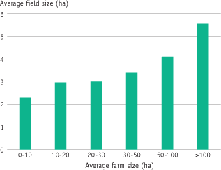
The figure shows the trend in sizes of farms from 1998-2003 (at the top) and the average size of fields relative to the average size of farms in 2003 (below). The development in agriculture is characterised by concentration of production on still fewer farms, which in turn are growing ever larger. The large farms often use a technology which requires large uniform fields. With the subsequent merging of fields and discontinuation of hedgerows between fields, part of the many small biotopes that serve as habitats for certain animals and plants disappear.
Source: National Environmental Research Institute (NERI), Miljøtilstandsrapport 2005 (The State of the Environment in Denmark 2005)
4 LARGE LIVESTOCK FARMS
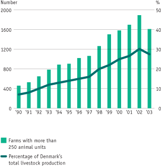
Source: Statistics Denmark
The graph shows the development in the number of farms with more than 250 animal units between 1990 and 2003. The number of animals per animal unit depends on the species. For example, one animal unit is equivalent to one dairy cow or 36 pigs. Thus a piggery with 250 animal units would have 9,000 pigs.
The trend toward large-scale operation is seen most evidently in agriculture where the number of large farms with more than 250 animal units has more than quadrupled since 1990. In 2002, the number of large livestock farms reached 1,896, of which 1,302 were piggeries. In 2003 we see a drop in the number of large livestock farms. A likely reason for this drop is the overall structural development within agriculture leading to fewer but ever larger farms. Apparently, this trend is now also evident for the already-large farms in livestock farming (more than 250 animal units). However, it is still too soon to draw any final conclusions on the basis of a drop in numbers in one year. The large livestock farms today account for one quarter of Denmark's total livestock production.
In some cases, livestock farming causes odour nuisances when located too close to houses and villages. Therefore the distance requirements for livestock farming were tightened in 2004. Emissions of ammonia from livestock farms pose another problem, leading to acidification and over-fertilisation of natural areas. Most natural areas have already reached their critical load. The deposition of ammonia may be very large especially close to the livestock farm. This leads to local problems with deposition of nutrients e.g. in West Jutland where vulnerable heath land depends on nutrient-poor growth conditions.
The political agreement on Action Plan for the Aquatic Environment III calls for the establishment of protection zones around especially vulnerable areas. This protection or buffer zone will be 300 m wide and will be established around all raised bogs, all lobelia lakes (lime and nutrient-poor lakes and ponds/waterholes), and principally all threatened heaths, dry grasslands and other especially vulnerable habitat types in Natura 2000 sites. Within these buffer zones there can be no livestock farm expansions that will lead to increased emissions of ammonia.
When manure and slurry is spread on fields, nitrogen and phosphorous are added. If more nitrogen is added than is absorbed by plants or stored and converted in the soil, nitrogen will be washed out and damage the aquatic environment. Too heavy nutrient loads can lead to oxygen depletion in fjords and the sea. Therefore, there must be a balance between manure production and farmland area. Rules for this are laid out in the harmony requirement in the Danish Statutory Order on Manure. From 1990 to 2003 an average of about 88,000 tonnes nitrogen and about 3,300 tonnes phosphorous were added annually to Danish farmland.
Since adoption of the first action plan for the aquatic environment in 1987, great efforts to reduce leaching and runoff of nutrients have been made, and, today, animal manure is being exploited far more optimally than previously, so that the demand for commercial fertiliser has been reduced.
5 THE OPEN COUNTRYSIDE
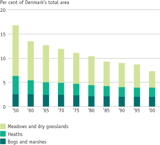
Source: Danish Forest and Nature Agency
The graph shows the area development for meadows and dry grasslands, heaths, and marshes from 1950 to 2000.
The area of the three types of natural habitat has fallen dramatically over the past 100 years. This is because the open countryside and semi-natural areas have long since lost their financial significance and today exist on only 9 per cent of the land. The dunes along the west coast of Denmark are largely used as summerhouse areas, while the heaths and marshes in many other places have been converted to agricultural use or forests. Meadows and dry grasslands, the previously common areas around villages, are now rarely used for grazing and hay. Instead they are becoming overgrown with herbs and scrub. Overgrowing, together with draining and over fertilising pose the greatest threats to the rich biological diversity in meadows and dry grasslands.
6 THE AREA OF DECIDUOUS TREES
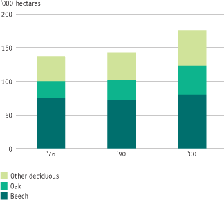
Source: Statistics Denmark
The graph shows the area of deciduous trees in 1976, 1990 and in 2000, broken down into beech, oak, and other deciduous. The total area of deciduous forest has increased over the period.
The area of Danish forests is increasing, and between 1990 and 2000 the increase has been relatively greater for deciduous trees than for conifers. The total forest area in 2000 was 468,000 hectares, of which 293,000 hectares were coniferous forest, and 175,000 hectares deciduous.
Both private and stateowned forests are working with the transition to near-nature forestry. In particular, it is hoped to increase the area of deciduous forest. From 1990-1999 about 70,000 hectares of forest in Denmark were regenerated, and deciduous trees were used on approximately 25,000 hectares of this area, while coniferous trees were used on 45,000 hectares.
7 THE AREA OF CONIFEROUS TREES
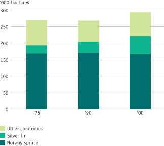
Source: Danish Forest and Nature Agency
The graph shows the changes in the total area of coniferous trees in Denmark broken down into Norway spruce, silver fir, and other coniferous trees.
During the 1990s, the area of forests increased by five per cent. Almost half of the increase arose because of Christmas
tree and decorative greenery cultivation on old agricultural land. The area with Christmas trees and decorative greenery now makes up some 35,000 hectares, and the majority of the pesticides used in
forestry are applied here. Many areas planted with Christmas trees are on former farmland. In 2000 between 10 and 11 million Christmas trees were produced.
The windfalls in 1999 resulting from the powerful storm that struck Denmark in December 1999 have changed the Danish forests.
90 per cent of the overturned trees were conifers, and to a large extent these are being replaced by deciduous trees. Mixed forests can better withstand storms than conifer plantations, and they are habitats for more animals and plants.
8 AFFORESATION
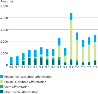
Source: National Environmental Research Institute (NERI), Miljøtilstandsrapport 2005 (The State of the Environment in Denmark 2005); based on data from Danish Forest and Nature Agency
The Danish Parliament decided in 1989 to double Denmark's area of forest within the next 80 to 100 years, corresponding to one tree generation. Afforestation is carried out by state efforts in state forests and by subsidised private efforts. If the goal is to be met, an average of 4-5,000 hectares of trees must be planted each year, which up trough the 1990s would have meant a total of about 45,000 hectares. About half of this area was planted in this period, and only in one year (1999) was the target met.
The new forests mainly have deciduous cover. This is a consequence of increased subsidies for planting deciduous trees, and the requirement for small afforestation projects to include deciduous trees. The state windfall scheme from 2000, which supports replanting of trees felled by the storm in 1999, promotes afforestation of areas with indigenous species more resilient than those lost to windfall and which may develop into forests with greater biodiversity. The damage following the storm in 1999 was as extensive as it was because large parts of Danish forests consist of old stands of Norway spruce, which is not particularly resilient to high wind gusts.
Version 1.0 December 2005, © Danish Environmental Protection Agency