Establishment of a basis for administrative use of PestSurf
Annex 10
10 Comparison of risk assessment data produced by spray drift assessments, FOCUS SW and PestSurf
10.1 Chemical characteristics of the compound
| Compound: | Rimsulfuron |
| Dose: | 30 g ai/ha |
| Spraying time: | 17th June |
| Crop: | Potatoes |
Table 10.1. Overview of chemical properties of rimsulfuron and the parameters used in the simulations.
Tabel 10.1. Oversigt over rimsulfuron s kemiske egenskaber og parametrene brugt i simuleringerne.
| Chemical property | Condition | Recalculated values | |||
| Cas-no. | 122931-48-0 | ||||
| Molecular weight | 431.45 | ||||
| Form (acid, basic, neutral) | acid | ||||
| pKa | 4 | ||||
| Water solubility | 7.3 g/l | pH 7 | |||
| log Kow | 0.288 | at pH | 5 | KowA- | -1.87 |
| log Kow | -1.46 | at pH | 7 | KowAH | 1.32 |
| log Kow | at pH | KowAH+ | |||
| Vapor pressure, Pa | 8.9 × 10⁻⁷ | 20°C | 270°C (Decomposition) | vapor pressure, Pa, 20°C | |
| Henry’s law constant | 4.6 × 10⁻⁶ Pa m³ mol-1 | 25°C | pH 5 | Recalculated value, dimensionless | |
| 8,3 × 10⁻⁸ Pa m³ mol-1 | 25°C | pH 7 | 3.35 x 10⁻¹¹ | ||
| 1.1 × 10⁻⁷ Pa m³ mol-1 | 25°C | pH 9 | |||
| Sorption properties in soil | |||||
| Freundlich exp | 1 | ||||
| Koc, l/kg | 42.4 | ||||
| DT50 in soil, days | 16.8 | ||||
| DT50water | 4 days | PestSurf input | |||
| DT50sedment | 10.5 days | ||||
| DT50water/sediment | 6 days | method not described | DT50, days | 6 | |
| Sediment konc., µg/l | 80 (default in PestSurf) | ||||
| Hydrolysis | 4.7 | at pH 5 | (acid) | 7.49 × 10⁻⁵ | |
| 7.3 | at pH 7 | (neutral) | 12.6 | ||
| 4.2 | at pH 9 | (basic) | 1.77 × 10⁻⁶ | ||
| Photolysis | |||||
| quantum yield | |||||
| Spectrum | pH 5.0 ε | ||||
| λ: 240: 2.24e4 l.mol-1.cm-1 λ 290: 4.81e2 l.mol-1.cm-1 PestSurf allows spectrum to be defined from 295-300 nm: so 481 is specified for this range. |
|||||
| Other | Rimsulfuron (25°C, natural sunlight: 39° 40’ N): pH 5: 1.1 d, pH 7: 11.7 d, pH 9: 11.1 h | ||||
10.2 Concentration generated by spray
| Direct spray | FOCUS buffer zones | |||
| Ditch | Stream | Pond | ||
| µg l-1 | µg l-1 | µg l-1 | µg l-1 | |
| Rimsulfuron | 10.0 | 0.213 | 0.155 | 0.075 |
10.3 Concentrations generated by FOCUS SW
10.3.1 D3- Ditch
| Rimsulfuron | Ditch, D3 | |||||||
| Water | Sediment | |||||||
| Date | PEC | Date | TWAEC | Date | PEC | Date | TWAEC | |
| µg l-1 | µg l-1 | µg kg-1 | µg kg-1 | |||||
| Global max | 26-jun-92 | 0.159 | 27-jun-92 | 0.018 | ||||
| 1 d | 27-jun-92 | 0.063 | 27-jun-92 | 0.117 | 28-jun-92 | 0.012 | 27-jun-92 | 0.017 |
| 2 d | 28-jun-92 | 0.007 | 28-jun-92 | 0.072 | 29-jun-92 | 0.009 | 28-jun-92 | 0.015 |
| 4 d | 30-jun-92 | 0.002 | 30-jun-92 | 0.038 | 01-jul-92 | 0.006 | 30-jun-92 | 0.012 |
| 7 d | 03-jul-92 | 0.002 | 03-jul-92 | 0.022 | 04-jul-92 | 0.004 | 03-jul-92 | 0.009 |
10.3.2 D4 – Stream
| Rimsulfuron | Stream, D4 | |||||||
| Water | Sediment | |||||||
| Date | PEC | Date | TWAEC | Date | PEC | Date | TWAEC | |
| µg l-1 | µg l-1 | µg kg-1 | µg kg-1 | |||||
| Global max | 21-jun-85 | 0.132 | 25-jul-85 | 0.023 | ||||
| 1 d | 22-jun-85 | 0.008 | 24-jul-85 | 0.069 | 26-jul-85 | 0.022 | 26-jul-85 | 0.023 |
| 2 d | 23-jun-85 | 0.008 | 24-jul-85 | 0.067 | 27-jul-85 | 0.022 | 26-jul-85 | 0.023 |
| 4 d | 25-jun-85 | 0.008 | 26-jul-85 | 0.059 | 29-jul-85 | 0.021 | 04-aug-85 | 0.022 |
| 7 d | 28-jun-85 | 0.007 | 29-jul-85 | 0.049 | 01-aug-85 | 0.023 | 05-aug-85 | 0.022 |
10.3.3 D4 - Pond
| Rimsulfuron | Pond, D4 | |||||||
| Water | Sediment | |||||||
| Date | PEC | Date | TWAEC | Date | PEC | Date | TWAEC | |
| µg l-1 | µg l-1 | µg kg-1 | µg kg-1 | |||||
| Global max | 02-aug-85 | 0.012 | 02-jan-86 | 0.007 | ||||
| 1 d | 03-aug-85 | 0.012 | 03-aug-85 | 0.012 | 03-jan-86 | 0.007 | 03-jan-86 | 0.007 |
| 2 d | 04-aug-85 | 0.011 | 03-aug-85 | 0.012 | 04-jan-86 | 0.007 | 03-jan-86 | 0.007 |
| 4 d | 06-aug-85 | 0.01 | 04-aug-85 | 0.011 | 06-jan-86 | 0.007 | 04-jan-86 | 0.007 |
| 7 d | 09-aug-85 | 0.007 | 06-aug-85 | 0.011 | 09-jan-86 | 0.006 | 06-jan-86 | 0.007 |
10.3.4 Conclusion – FOCUS SW
The highest concentration is generated in the ditch (D3). It is caused by wind drift and the concentration becomes 0.159 µg/l. The D4-stream scenario shows the highest concentration in the sediment, 0.023 µg/l. For all scenarios, the concentrations are lower than what is generated by the simpler assessments, but for the ditch and stream-scenarios the difference between the simple drift calculation and the FOCUS SW-simulation is rather small.
10.4 PestSurf
10.4.1 Sandy Catchment, stream
The distribution of concentrations was assessed in several steps. First, the maximum concentrations at each calculation point were listed, and the dates for the occurrence of the maximum were assessed. The points, for which the maximum value also represents a local maximum were selected for further analysis. The relevant values are listed in Table 10.2.
Table 10.2. Maximum concentrations (ng/l) of rimsulfuron simulated for each calculation point in the sandy catchment.
Tabel 10.2. Maximumkoncentrationer (ng/l) af rimsulfuron simuleret for hvert beregningspunkt i det sandede opland.
| RIMSULFURON | Maximum | Max. Time | Local maxima |
| ODDERBAEK 0.00 | 50 | 19-06-1998 09:18 | |
| ODDERBAEK 56.00 | 53 | 19-06-1998 09:08 | |
| ODDERBAEK 112.00 | 64 | 19-06-1998 09:00 | |
| ODDERBAEK 192.00 | 136 | 19-06-1998 08:41 | |
| ODDERBAEK 272.00 | 216 | 19-06-1998 08:33 | |
| ODDERBAEK 278.00 | 225 | 19-06-1998 08:33 | |
| ODDERBAEK 282.00 | 232 | 19-06-1998 08:33 | |
| ODDERBAEK 298.50 | 249 | 19-06-1998 08:33 | |
| ODDERBAEK 315.00 | 268 | 19-06-1998 08:33 | |
| ODDERBAEK 317.50 | 271 | 19-06-1998 08:33 | |
| ODDERBAEK 320.00 | 274 | 19-06-1998 08:33 | |
| ODDERBAEK 410.00 | 359 | 19-06-1998 08:33 | |
| ODDERBAEK 500.00 | 404 | 19-06-1998 08:33 | |
| ODDERBAEK 513.00 | 424 | 19-06-1998 08:33 | |
| ODDERBAEK 521.00 | 438 | 19-06-1998 08:33 | |
| ODDERBAEK 622.00 | 519 | 19-06-1998 08:33 | |
| ODDERBAEK 723.00 | 582 | 19-06-1998 08:33 | |
| ODDERBAEK 733.00 | 600 | 19-06-1998 08:33 | |
| ODDERBAEK 742.00 | 610 | 19-06-1998 08:33 | |
| ODDERBAEK 789.50 | 639 | 19-06-1998 08:33 | |
| ODDERBAEK 837.00 | 667 | 19-06-1998 08:33 | |
| ODDERBAEK 848.00 | 679 | 19-06-1998 08:33 | |
| ODDERBAEK 863.00 | 693 | 19-06-1998 08:33 | |
| ODDERBAEK 956.00 | 741 | 19-06-1998 08:33 | |
| ODDERBAEK 1049.00 | 747 | 19-06-1998 08:33 | x |
| ODDERBAEK 1111.50 | 723 | 25-06-2001 08:33 | |
| ODDERBAEK 1174.00 | 657 | 25-06-2005 08:32 | |
| ODDERBAEK 1226.00 | 616 | 25-06-2005 08:32 | |
| ODDERBAEK 1278.00 | 599 | 25-06-2005 08:42 | |
| ODDERBAEK 1293.50 | 591 | 25-06-2005 08:42 | |
| ODDERBAEK 1310.00 | 578 | 25-06-2005 08:42 | |
| ODDERBAEK 1421.00 | 551 | 25-06-2005 08:51 | |
| ODDERBAEK 1532.00 | 477 | 19-06-1998 08:33 | |
| ODDERBAEK 1558.06 | 433 | 19-06-1998 08:33 | |
| ODDERBAEK 1584.12 | 414 | 19-06-1998 08:41 | |
| ODDERBAEK 1584.12 | 414 | 19-06-1998 08:41 | |
| ODDERBAEK 1621.06 | 414 | 19-06-1998 08:33 | |
| ODDERBAEK 1658.00 | 425 | 19-06-1998 08:33 | |
| ODDERBAEK 1698.50 | 440 | 19-06-1998 08:33 | |
| ODDERBAEK 1739.00 | 449 | 19-06-1998 08:33 | x |
| ODDERBAEK 1801.50 | 435 | 19-06-1998 08:33 | |
| ODDERBAEK 1864.00 | 356 | 17-06-2004 08:33 | |
| ODDERBAEK 1977.00 | 271 | 17-06-2000 09:54 | |
| ODDERBAEK 2090.00 | 265 | 17-06-2000 10:00 | |
| ODDERBAEK 2098.00 | 265 | 17-06-2000 10:00 | |
| ODDERBAEK 2105.00 | 264 | 17-06-2000 10:00 | |
| ODDERBAEK 2131.00 | 263 | 17-06-2000 10:00 | |
| ODDERBAEK 2157.00 | 260 | 17-06-2000 10:00 | |
| ODDERBAEK 2168.00 | 258 | 17-06-2000 10:00 | |
| ODDERBAEK 2179.00 | 257 | 17-06-2000 10:00 | |
| ODDERBAEK 2268.50 | 253 | 17-06-2004 10:00 | |
| ODDERBAEK 2358.00 | 239 | 17-06-2004 10:00 | |
| ODDERBAEK 2363.50 | 238 | 17-06-2004 10:00 | |
| ODDERBAEK 2372.00 | 237 | 17-06-2004 10:00 | |
| ODDERBAEK 2427.00 | 234 | 17-06-2004 10:00 | |
| ODDERBAEK 2482.00 | 228 | 17-06-2004 10:00 | |
| ODDERBAEK 2609.00 | 225 | 25-06-2001 11:00 | |
| ODDERBAEK 2736.00 | 213 | 17-06-2000 11:00 | |
| ODDERBAEK 2831.00 | 211 | 17-06-2000 11:00 | |
| ODDERBAEK 2926.00 | 198 | 17-06-2000 11:00 | |
| ODDERBAEK 2958.50 | 195 | 17-06-2004 11:00 | |
| ODDERBAEK 2991.00 | 193 | 17-06-2004 11:00 | |
| ODDERBAEK 3029.50 | 187 | 17-06-2004 11:00 | |
| ODDERBAEK 3068.00 | 177 | 17-06-2004 11:00 | |
| ODDERBAEK 3131.00 | 165 | 17-06-2004 11:00 | |
| ODDERBAEK 3194.00 | 154 | 17-06-2000 12:00 | |
| ODDERBAEK 3250.50 | 153 | 17-06-2004 12:00 | |
| ODDERBAEK 3307.00 | 153 | 19-06-1998 08:33 | |
| ODDERBAEK 3315.00 | 155 | 19-06-1998 08:33 | |
| ODDERBAEK 3323.00 | 161 | 19-06-1998 08:33 | |
| ODDERBAEK 3355.50 | 179 | 19-06-1998 08:33 | |
| ODDERBAEK 3388.00 | 200 | 19-06-1998 08:33 | |
| ODDERBAEK 3438.50 | 231 | 19-06-1998 08:33 | |
| ODDERBAEK 3489.00 | 246 | 19-06-1998 08:33 | |
| ODDERBAEK 3499.50 | 247 | 19-06-1998 08:33 | x |
| ODDERBAEK 3510.00 | 247 | 19-06-1998 08:33 | |
| ODDERBAEK 3581.00 | 244 | 19-06-1998 08:33 | |
| ODDERBAEK 3652.00 | 219 | 19-06-1998 08:33 | |
| ODDERBAEK 3707.00 | 206 | 19-06-1998 08:41 | |
| ODDERBAEK 3762.00 | 192 | 19-06-1998 08:41 | |
| ODDERBAEK 3790.00 | 170 | 19-06-1998 08:41 | |
| ODDERBAEK 3818.00 | 137 | 19-06-1998 08:41 | |
| ODDERBAEK 3818.00 | 137 | 19-06-1998 08:41 | |
| ODDERBAEK 3884.00 | 131 | 19-06-1998 08:41 | |
| ODDERBAEK 3950.00 | 125 | 19-06-1998 08:51 | |
| ODDERBAEK 3998.00 | 117 | 19-06-1998 08:51 | |
| ODDERBAEK 4046.00 | 109 | 19-06-1998 09:00 | |
| ODDERBAEK 4047.50 | 109 | 19-06-1998 09:00 | |
| ODDERBAEK 4049.00 | 109 | 19-06-1998 09:00 | |
| ODDERBAEK 4052.50 | 109 | 19-06-1998 09:00 | |
| ODDERBAEK 4056.00 | 109 | 19-06-1998 09:00 | |
| ODDERBAEK 4058.00 | 109 | 19-06-1998 09:00 | |
| ODDERBAEK 4060.00 | 109 | 19-06-1998 09:00 | |
| ODDERBAEK 4080.00 | 108 | 25-06-2005 09:00 | |
| ODDERBAEK 4100.00 | 108 | 25-06-2005 09:00 | |
| ODDERBAEK 4134.00 | 109 | 25-06-2005 09:00 | |
| ODDERBAEK 4168.00 | 109 | 25-06-2005 09:00 | |
| GISLUM_ENGE_AFLOEB 0.00 | 5 | 01-04-1999 00:00 | |
| GISLUM_ENGE_AFLOEB 50.00 | 7 | 01-04-1999 00:00 | |
| GISLUM_ENGE_AFLOEB 100.00 | 6 | 01-04-1999 00:00 | |
| GISLUM_ENGE_AFLOEB 150.00 | 7 | 31-03-1999 00:00 | |
| GISLUM_ENGE_AFLOEB 200.00 | 6 | 25-03-1999 00:00 | |
| GISLUM_ENGE_AFLOEB 250.00 | 7 | 25-03-1999 00:00 | |
| GISLUM_ENGE_AFLOEB 300.00 | 7 | 01-04-1999 00:00 | |
| GISLUM_ENGE_AFLOEB 340.00 | 7 | 01-04-1999 00:00 | |
| GISLUM_ENGE_AFLOEB 380.00 | 7 | 01-04-1999 00:00 | |
| GISLUM_ENGE_AFLOEB 430.00 | 7 | 31-03-1999 00:00 | |
| GISLUM_ENGE_AFLOEB 480.00 | 7 | 31-03-1999 00:00 | |
| GISLUM_ENGE_AFLOEB 530.00 | 7 | 31-03-1999 00:00 | |
| GISLUM_ENGE_AFLOEB 580.00 | 7 | 31-03-1999 00:00 | |
| GISLUM_ENGE_AFLOEB 630.00 | 7 | 02-04-1999 00:00 | |
| GISLUM_ENGE_AFLOEB 680.00 | 7 | 02-04-1999 00:00 | |
| GISLUM_ENGE_AFLOEB 730.00 | 7 | 02-04-1999 00:00 | |
| GISLUM_ENGE_AFLOEB 780.00 | 7 | 02-04-1999 00:00 | |
| GISLUM_ENGE_AFLOEB 830.00 | 7 | 02-04-1999 00:00 | |
| GISLUM_ENGE_AFLOEB 880.00 | 7 | 02-04-1999 00:00 | |
| GISLUM_ENGE_AFLOEB 915.00 | 8 | 02-04-1999 00:00 | |
| GISLUM_ENGE_AFLOEB 950.00 | 8 | 02-04-1999 00:00 | |
| GISLUM_ENGE_AFLOEB 985.00 | 8 | 02-04-1999 00:00 | |
| GISLUM_ENGE_AFLOEB 1020.00 | 8 | 02-04-1999 00:00 | |
| GISLUM_ENGE_AFLOEB 1045.00 | 8 | 02-04-1999 00:00 | |
| GISLUM_ENGE_AFLOEB 1070.00 | 8 | 02-04-1999 00:00 | |
| GISLUM_ENGE_AFLOEB 1110.00 | 8 | 02-04-1999 00:00 | |
| GISLUM_ENGE_AFLOEB 1150.00 | 8 | 02-04-1999 00:00 | |
| GISLUM_ENGE_AFLOEB 1190.00 | 8 | 02-04-1999 00:00 | |
| GISLUM_ENGE_AFLOEB 1230.00 | 7 | 02-04-1999 00:00 | |
| GISLUM_ENGE_AFLOEB 1271.00 | 7 | 02-04-1999 00:00 | |
| GISLUM_ENGE_AFLOEB 1312.00 | 7 | 02-04-1999 00:00 | |
| GISLUM_ENGE_AFLOEB 1422.00 | 29 | 19-06-1998 08:51 | |
| GISLUM_ENGE_AFLOEB 1532.00 | 137 | 19-06-1998 08:41 | |
| TILLOEB 0.00 | 399 | 19-06-1998 08:41 | |
| TILLOEB 20.16 | 408 | 19-06-1998 08:41 | |
| TILLOEB 40.31 | 414 | 19-06-1998 08:41 | x |
| global max | 747 |
The pattern over time was the same for all calculation points. The peak values are generated by wind drift contributions, see Figure 10.1. However, small drainage contributions are visible, particularly after wet winters. The concentrations reach 747 ng/l.
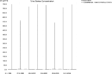
Figure 10.1. Concentration pattern over time for rimsulfuron in the sandy catchment, 1049 m from the upstream end. The concentration patterne is representative for the entire catchment.
Figur 10.1. Koncentrationsmønster som funktion af tid for rimsulfuron i det sandede opland, 1049 m fra den opstrøms ende. Koncentrationsmønsteret er repræsentativt for hele oplandet.
The time of maximum concentration differ along the stream, see Figure 10.2 to Figure 10.5 and Table 10.2. The thin black line represents the concentration, while the thick black dotted line shows the maximum concentrations obtained during the simulations. In addition, the outline of the stream is shown. Four plots of 19 June 1998, producing maximum concentrations in the upper and middle section of the stream are shown.
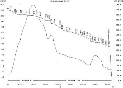
Figure 10.2. Concentrations of rimsulfuron in the sandy catchment on 19. June, 1998, 8.33. The concentration peaks in the upstream end
Figur 10.2. Koncentrationer rimsulfuron i det sandede opland den 19. juni 1998, 8.33.

Figure 10.3. Concentrations of rimsulfuron in the sandy catchment on 19. June, 1998, 8.51.
Figur 10.3. Koncentrationer rimsulfuron i det sandede opland den 19. juni 1998, 8.51.
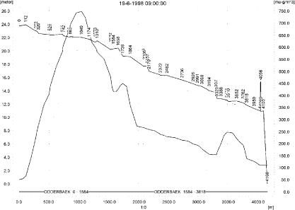
Figure 10.4. Concentrations of rimsulfuron in the sandy catchment on 19. June, 1998, 9.00.
Figur 10.4. Koncentrationer Rimsulfuron i det sandede opland den 19. juni 1998, 9.00.
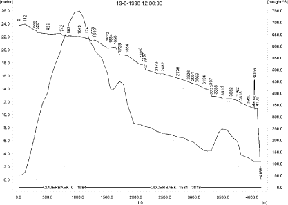
Figure 10.5. Concentrations of rimsulfuron in the sandy catchment on 19. June, 1998, 12.00.
Figur 10.5. Koncentrationer rimsulfuron i det sandede opland den 19. juni 1998, 12.00.
In order to present the data in a similar fashion to the FOCUS SW-results, data were extracted and recalculated for the time series marked in Table 10.2. The global maxima and time weighted concentrations (up to 7 days) were extracted and are reported in Table 10.3. Note that the unit is ng/l.
Table 10.3. Instantaneous and time-weighted concentration (ng/l) of rimsulfuron at selected points in the sandy stream.
Tabel 10.3. Beregnet og tidsvægtet koncentration af rimsulfuron, ng/l, på udvalgte lokaliteter i det sandede vandløb.
The pattern of pesticide sorbed to macrophytes can be seen in Figure 10.6. The pattern more or less follows the concentration in the water and the maximum concentration reached is 44 ng/l. The pattern of concentrations in pore water and sediment is shown in Figure 10.7 and Figure 10.8. The maximum concentration in sediment was calculated to be 0.51 ng/kg.
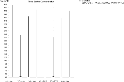
Figure 10.6. Typical concentration pattern for rimsulfuron sorbed on macrophytes.
Figur 10.6. Typisk koncentrationsmønster for rimsulfuron sorberet på makrofytter.
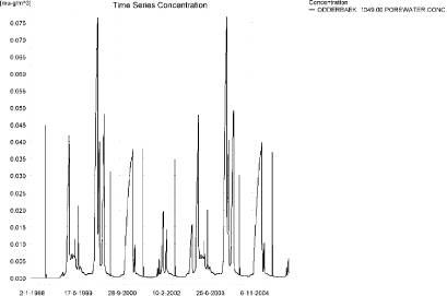
Figure 10.7. Example of concentration pattern for rimsulfuron in pore water in the sandy catchment. The highest concentration reached is 0.121 ng/l 56 m from the upstream end.
Figur 10.7. Eksempel på koncentrationsmønstre for for rimsulfuron i porevand i det sandede opland. Den højest opnåede koncentration er 0.121 ng/l 56 m fra den opstrøms ende.
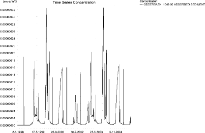
Figure 10.8. Concentration pattern for rimsulfuron sorbed to sediment in the sandy catchment. The concentration is in µg/g sediment and not µg/m³ as stated. The maximum concentration, 0.51 ng/kg, is reached 56 m from the upstream end.
Figur 10.8. Koncentrationsmønster for rimsulfuron sorberet til sediment i det sandede vandløb. Koncentrationen er i µg/g og ikke i µg/m³ som angivet. Maximumskoncentrationen, 0.51 ng/kg opnås 56 m fra den opstrøms ende.
The global maximum value calculated by PestSurf for the sandy catchment in the water phase is 747 ng/l. This is more than what is found in the D3-ditch scenario (159 ng/l). The concentration in sediment is low in both cases, but very low in the PestSurf calculation, 0.51 ng/kg against 18 ng/kg in the FOCUS D3-ditch.
Figure 10.9 shows the output of the PestSurf Excel template. The template works with pre-defined data extraction points. The plot requires specification of a “lowest detection value” (ldc) which defines when a pesticide occurrence is defined as an event. The time series plot is identical to the time series shown earlier, and the graph in the upper right corner resembles the plots in Figure 10.2 to Figure 10.5, but takes into account a longer period of time. A curve is generated when a downstream point reaches a concentration higher than the ldc. The programme then tracks the highest concentration for each calculation point in the stream within the last 24 hours. The plot in the lower right corner shows how many events have concentrations higher than a given value (ldc) for the selected monitoring points.
Table 10.4 shows part of the result sheet generated by the PestSurf Excel sheet based on the ldc-value. The selected table shows the point along the stream (of the pre-defined points) with the highest concentration. This value was, however, only 414 ng/l. Thus, the pre-defined points have not caught the highest concentration of the simulation, which was 747 ng/l.
Click here to see Figure 10.9.
Figure 10.9. Overview for rimsulfuron in the sandy catchment generated by the PestSurf excel template. The maximum concentrations generated over the 24 hours are similar to to the overviews in Figure 10.2 to Figure 10.5. The graph to the lower right shows how many events have concentrations higher than a given value for the selected monitoring points. Detection value was set to 0.5 ng/l.
Figur 10.9. Oversigt for rimsulfuron i det sandede opland genereret med PestSurf-excel-skabelonen. Den maximale koncentration genereret over 24 timer svarer til oversigten i Figur 10.2 til Figur 10.5. Grafen nederst til højre viser hvor mange hænderlser, der har koncentrationer størrre end end given værdi for de fordefinerede lokaliteter. Detektionsgrænsen var sat til 0.5 ng/l.
Table 10.4. Part of the result sheet generated by the PestSurf Excel sheet. The selected table shows the point along the stream with the highest concentration recorded. The lowest detection value is 0.5 ng/l, toxicity to fish, daphnies and algae are set to 1, 10 and 100 ng/l, respectively. The recorded peaks are shown in Figure 10.9.
Tabel 10.4. Uddrag af resultatpresentationen genereret af PestSurf-Excel-arket. Den udvalgte tabel viser det fordefinerede punkt langs med åen med højest koncentration. Detektionsgrænsen er sat til 0.5 ng/l mens toxicitetsværdierne for fisk, dafnier og alger er henholdsvis 1, 10 og 100 ng/l. De tabellerede hændelser er vist i Figur 10.9.
10.4.2 Sandy Catchment, pond
The concentration pattern is evaluated in the middle of the pond only, see Figure 10.10. The pond receives drift but the contribution through groundwater dominates the picture during the whole simulation period. The maximum concentration is 32.1 ng/l. The top occurs 6-7. July 1999. Spraying was carried out the 22 June, and it rained every day from 25 June to 6 July, notably on 27 June (14.7 mm), 30 June (8.7 mm) and 6 July (31.6 mm), in total 78 mm.
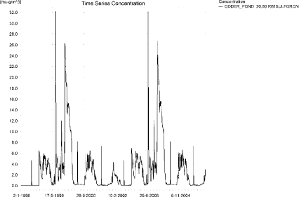
Figure 10.10. Concentrations of rimsulfuron in the sandy pond.
Figur 10.10. Koncentration af rimsulfuoron i det sandede vandhul.
In Table 10.5, global maxima and time weighted concentrations (up to 7 days) were extracted.
Table 10.5. Maximum concentrations of rimsulfuron (ng/l) generated in the sandy pond.
Tabel 10.5. maximumkoncentrationer af rimsulfuron (ng/l) genereret for det sandede vandhul.
| Year | ODDER_POND 20.00, | |||
| Conc. | TWC | Date | ||
| 1998 | 1998 (global max) | 6 | 22-10-1998 | |
| 1 hour (after max) | ||||
| 1 day after sp.in. | 6 | 6 | ||
| 2 days | 6 | 6 | ||
| 4 days | 6 | 6 | ||
| 7 days | 5 | 6 | ||
| 1999 | 1999 (global max) | 32 | 08-07-1999 | |
| 1 hour (after max) | 32 | 32 | ||
| 1 day after sp.in. | 28 | 31 | ||
| 2 days | 20 | 26 | ||
| 4 days | 17 | 24 | ||
| 7 days | 10 | 19 | ||
| 2000 | 2000 (global max) | 17 | 02-01-2000 | |
| 1 hour (after max) | ||||
| 1 day after sp.in. | 16 | 17 | ||
| 2 days | 14 | 16 | ||
| 4 days | 14 | 16 | ||
| 7 days | 15 | 15 | ||
| 2001 | 2001 (global max) | 7 | 25-06-2001 | |
| 1 hour (after max) | 6 | 6 | ||
| 1 day after sp.in. | 4 | 5 | ||
| 2 days | 2 | 3 | ||
| 4 days | 1 | 3 | ||
| 7 days | 0 | 2 | ||
| 2002 | 2002 (global max) | 7 | 22-10-2002 | |
| 1 hour (after max) | ||||
| 1 day after sp.in. | 7 | 7 | ||
| 2 days | 6 | 6 | ||
| 4 days | 6 | 6 | ||
| 7 days | 6 | 6 | ||
| 2003 | 2003 (global max) | 32 | 08-07-2003 | |
| 1 hour (after max) | 32 | 32 | ||
| 1 day after sp.in. | 28 | 31 | ||
| 2 days | 20 | 26 | ||
| 4 days | 17 | 24 | ||
| 7 days | 10 | 19 | ||
| 2004 | 2004 (global max) | 17 | 02-01-2004 | |
| 1 hour (after max) | ||||
| 1 day after sp.in. | 17 | 17 | ||
| 2 days | 15 | 16 | ||
| 4 days | 15 | 16 | ||
| 7 days | 15 | 15 | ||
| 2005 | 2005 (global max) | 7 | 25-06-2005 | |
| 1 hour (after max) | 6 | 6 | ||
| 1 day after sp.in. | 4 | 5 | ||
| 2 days | 2 | 3 | ||
| 4 days | 1 | 3 | ||
| 7 days | 0 | 2 | ||
| Global max | 32 | |||
| 1 hour (after max) | 32 | 32 | ||
| 1 day after sp.in. | 28 | 31 | ||
| 2 days | 20 | 26 | ||
| 4 days | 17 | 24 | ||
| 7 days | 15 | 19 | ||
Sorption to macrophytes and sediment is shown in Figure 10.11 and Figure 10.13, while the porewater concentration is shown in Figure 10.12. The sorption to macrophytes is small compared to the concentration in the water phase. The sorption to sediment reaches 1.35 ng/kg.
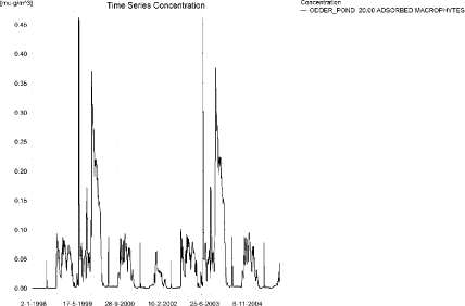
Figure 10.11. Sorption of rimsulfuron to macrophytes in the sandy pond.
Figur 10.11. Sorption af rimsulforon til makrofytter i det sandede vandhul.
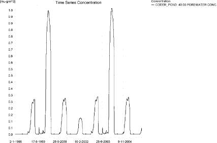
Figure 10.12. Concentration of rimsulfuron in porewater the sandy pond.
Figur 10.12. Porevandskoncentration af rimsulfuron i det sandede vandhul.
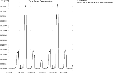
Figure 10.13. Sorption of rimsulfuron to sediment in the sandy pond. The concentration is in µg/g sediment and not µg/m³ as stated.
Figur 10.13. Sorption af rimsulfuron til sediment i det sandede vandhul. Koncentrationen er i µg/g og ikke i µg/m³ som angivet.
Compared to the FOCUS D3 ditch, the concentration in the PestSurf sandy pond is considerably lower, 32 µg/l compared to 159 ng/l. The ditch-concentration is caused by wind drift while the concentration in the sandy pond is caused by groundwater contribution. The sediment concentrations also differ, PestSurf reaching 1.4 ng/kg while the FOCUS D3-ditch reaches 1.8 ng/kg. In both cases the figures are small.
In the pond-case, there is no difference between the results of PestSurf and the results extracted by the templates.
Figure 10.14 shows the output of the PestSurf Excel template. The template works with one pre-defined data extraction point for the pond (center of the pond). The plot requires specification of a “lowest detection value” (ldc) which defines when a pesticide occurrence is defined as an event. The time series plot is identical to the time series shown earlier. The plot to the right shows how many events have concentrations higher than a given toxicity value for the selected monitoring points.
Table 10.9 shows part of the result sheet generated by the PestSurf Excel sheet based on the ldc-value.
Click here to see Figure 10.14.
Figure 10.14. Overview for rimsulfuron in the sandy pond generated by the PestSurf excel template. The time series shown is identical to the one in Figure 10.10. Lowest detection concentration was set to 1 ng/l.
Figur 10.14. Oversigt for rimsulfuron i det sandede vandhul genereret med PestSurf-excel-skabelonen. Den viste tidsserie er mage til den i Figur 10.10. Detektionsgrænsen er sat til 1 ng/l.
Table 10.6. Part of the result sheet generated by the PestSurf Excel sheet, applied to Rimsulfuron. The limiting value used for generation of the table is 1 ng/l. The toxicity values were set to 10,100 and 1000 ng/l, respectively. The recorded peaks are shown in Figure 10.14. EOF = End Of File.
Tabel 10.6. Uddrag af resultatpresentationen genereret af PestSurf-Excel-arket. Grænseværdien anvendt til tabelgenerering er sat til 1 ng/l mens toxicitetsværdierne for fisk, dafnier og alger er henholdsvis 10, 100 og 1000 ng/l. De tabellerede hændelser er vist i Figur 10.14. EOF = slutning af fil.
10.4.3 Sandy Loam catchment, Stream
The distribution of concentrations was assessed in several steps. First, the maximum concentrations at each calculation point were listed, and the dates for the occurrence of the maximum were assessed (Table 10.7). The points, for which the maximum value also represents a local maximum were selected for further analysis.
All points show the same type of time series pattern. The eight points with highest maximum values were analysed further.
Table 10.7. Maximum concentrations (ng/l) of rimsulfuron simulated for each calculation point in the sandy loam catchment.
Tabel 10.7. Maximumskoncentrationer (ng/l) af rimsulfuron simuleret for hvert beregningspunkt i morænelersoplandet.
| RIMSULFURON | Maximum | Max.Time | Local Maxima |
| ALBJERGBAEK 0.00 | 26 | 28-12-2001 00:00 | |
| ALBJERGBAEK 150.00 | 63 | 14-11-1998 00:00 | |
| ALBJERGBAEK 300.00 | 74 | 12-12-1997 00:00 | |
| ALBJERGBAEK 450.00 | 57 | 11-12-2001 00:00 | |
| ALBJERGBAEK 600.00 | 336 | 16-06-2001 11:00 | |
| ELHOLTBAEK 0.00 | 13 | 17-09-1998 00:00 | |
| ELHOLTBAEK 165.00 | 16 | 29-08-1998 00:00 | |
| ELHOLTBAEK 330.00 | 411 | 16-06-2000 08:40 | |
| FREDLIGBAEK 0.00 | 205 | 18-09-1998 00:00 | |
| FREDLIGBAEK 100.00 | 326 | 18-09-1998 00:00 | |
| FREDLIGBAEK 200.00 | 347 | 18-09-1998 00:00 | |
| FREDLIGBAEK 300.00 | 353 | 18-09-1998 00:00 | |
| FREDLIGBAEK 400.00 | 349 | 18-09-1998 00:00 | |
| FREDLIGBAEK 500.00 | 359 | 18-09-1998 00:00 | |
| FREDLIGBAEK 600.00 | 333 | 18-09-1998 00:00 | |
| FREDLIGBAEK 667.50 | 403 | 18-09-1998 00:00 | |
| FREDLIGBAEK 735.00 | 712 | 16-06-1998 08:40 | x |
| GROFTEBAEK 0.00 | 20 | 18-09-1998 00:00 | |
| GROFTEBAEK 155.00 | 31 | 17-09-1998 00:00 | |
| GROFTEBAEK 310.00 | 37 | 18-09-1998 00:00 | |
| GROFTEBAEK 465.00 | 25 | 22-09-1998 00:00 | |
| GROFTEBAEK 620.00 | 1043 | 16-06-2000 08:49 | x |
| STENSBAEK 0.00 | 15 | 01-09-1998 00:00 | |
| STENSBAEK 125.00 | 374 | 18-09-1998 00:00 | |
| STENSBAEK 250.00 | 220 | 18-09-1998 00:00 | |
| STENSBAEK 412.50 | 386 | 18-09-1998 00:00 | |
| STENSBAEK 575.00 | 258 | 18-09-1998 00:00 | |
| OVRELILLEBAEK 0.00 | 27 | 30-10-1998 00:00 | |
| OVRELILLEBAEK 125.00 | 909 | 16-06-1999 08:30 | |
| OVRELILLEBAEK 250.00 | 951 | 16-06-2000 08:30 | |
| OVRELILLEBAEK 290.00 | 1058 | 16-06-1998 08:30 | x |
| OVRELILLEBAEK 330.00 | 336 | 16-06-2001 11:00 | |
| OVRELILLEBAEK 330.00 | 336 | 16-06-2001 11:00 | |
| OVRELILLEBAEK 352.50 | 634 | 16-06-2000 08:30 | |
| OVRELILLEBAEK 375.00 | 258 | 18-09-1998 00:00 | |
| OVRELILLEBAEK 375.00 | 258 | 18-09-1998 00:00 | |
| OVRELILLEBAEK 437.50 | 535 | 16-06-2000 08:30 | |
| OVRELILLEBAEK 500.00 | 859 | 16-06-2000 08:30 | |
| OVRELILLEBAEK 625.00 | 1009 | 16-06-2001 08:30 | x |
| OVRELILLEBAEK 750.00 | 652 | 16-06-2000 08:30 | |
| OVRELILLEBAEK 855.00 | 952 | 16-06-2000 08:30 | |
| OVRELILLEBAEK 960.00 | 411 | 16-06-2000 08:40 | |
| OVRELILLEBAEK 960.00 | 411 | 16-06-2000 08:40 | |
| OVRELILLEBAEK 980.00 | 438 | 16-06-2000 08:49 | |
| OVRELILLEBAEK 1000.00 | 358 | 16-06-2000 08:49 | |
| OVRELILLEBAEK 1062.50 | 361 | 16-06-2000 08:30 | |
| OVRELILLEBAEK 1125.00 | 470 | 16-06-2000 08:30 | |
| OVRELILLEBAEK 1187.50 | 619 | 16-06-2000 08:30 | |
| OVRELILLEBAEK 1250.00 | 688 | 16-06-2000 08:30 | |
| OVRELILLEBAEK 1425.00 | 865 | 16-06-2000 08:30 | x |
| OVRELILLEBAEK 1600.00 | 677 | 16-06-2000 08:30 | |
| OVRELILLEBAEK 1650.00 | 864 | 16-06-2000 08:30 | |
| OVRELILLEBAEK 1700.00 | 456 | 16-06-2000 09:00 | |
| NEDRELILLEBAEK 0.00 | 456 | 16-06-2000 09:00 | |
| NEDRELILLEBAEK 135.00 | 531 | 16-06-2000 08:30 | |
| NEDRELILLEBAEK 270.00 | 900 | 16-06-2000 08:30 | |
| NEDRELILLEBAEK 330.00 | 1078 | 16-06-2000 08:30 | |
| NEDRELILLEBAEK 390.00 | 997 | 16-06-2000 08:30 | |
| NEDRELILLEBAEK 495.50 | 1119 | 16-06-2001 08:40 | x |
| NEDRELILLEBAEK 601.00 | 712 | 16-06-1998 08:40 | |
| NEDRELILLEBAEK 601.00 | 712 | 16-06-1998 08:40 | |
| NEDRELILLEBAEK 693.00 | 750 | 16-06-2000 08:30 | |
| NEDRELILLEBAEK 785.00 | 1252 | 16-06-2000 08:30 | |
| NEDRELILLEBAEK 847.00 | 1854 | 16-06-2000 08:30 | x |
| NEDRELILLEBAEK 909.00 | 1043 | 16-06-2000 08:49 | |
| NEDRELILLEBAEK 909.00 | 1043 | 16-06-2000 08:49 | |
| NEDRELILLEBAEK 984.50 | 920 | 16-06-2000 09:00 | |
| NEDRELILLEBAEK 1060.00 | 1366 | 16-06-2000 08:30 | |
| NEDRELILLEBAEK 1169.50 | 1696 | 16-06-2000 08:30 | |
| NEDRELILLEBAEK 1279.00 | 2348 | 16-06-2000 08:30 | x |
| NEDRELILLEBAEK 1409.50 | 999 | 16-06-2001 09:00 | |
| NEDRELILLEBAEK 1540.00 | 586 | 16-06-1999 09:30 | |
| global max | 2348 |
All maximum concentrations in the main stream are caused by wind drift events. Figure 10.15 and Figure 10.16 show the concentration pattern as it appears for the whole stream. Apart from the drift contribution, a high concentration is reached due to the extreme event in September 1998 (and 1994).
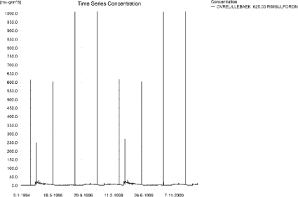
Figure 10.15. Concentration pattern for rimsulfuron in OvreLillebaek, 625 m from upstream, in the upstream end of the sandy loam catchment.
Figur 10.15. Koncentrationsmønster for rimsulfuron i Øvre Lillebæk (625 m fra opstrøms ende ) i den øvre del af morænelersoplandet.
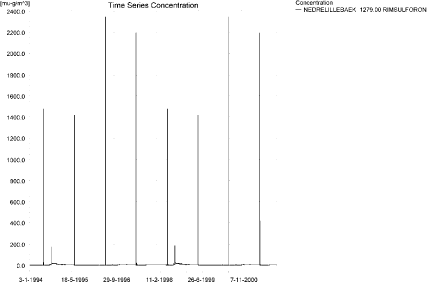
Figure 10.16. Concentration pattern for rimsulfuron in the lower end of the sandy loam catchment.
Figur 10.16. Koncentrationsmønster for rimsulfuron i i den nedre del af morænelersoplandet.
The concentrations in the sandy loam catchment on the 16 June 2000 at 8:30, 8:49, 9:00 and 12:00 hours after spraying, respectively, are shown in Figure 10.17 to Figure 10.20.
The thin black line represents the concentration, while the thick black line shows the maximum concentrations obtained during the simulations. In addition, the outline of the stream is shown.
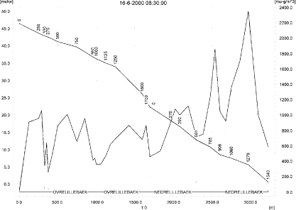
Figure 10.17. Concentrations in the sandy loam catchment on 16. June 2000, 8.30.
Figur 10.17. Koncentrationer i morænelersoplandet den 16. juni-2000, 08.30.

Figure 10.18. Concentrations in the sandy loam catchment on 16. June 2000, 8.50.
Figur 10.18. Koncentrationer i morænelersoplandet den 16. juni-2000, 08.50.

Figure 10.19. Concentrations in the sandy loam catchment on 16. June 2000, 9.00.
Figur 10.19. Koncentrationer i morænelersoplandet den 16. juni-2000, 09.00.
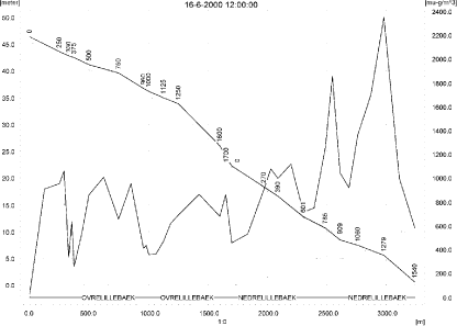
Figure 10.20. Concentrations in the sandy loam catchment on 16. June 2000, 12.00.
Figur 10.20. Koncentrationer i morænelersoplandet den 16. juni-2000, 12.00.
To be able to extract comparable values to FOCUS SW, the global maxima and time weighted concentrations (up to 7 days) were extracted when these were meaningful.
Figure 10.21 shows the concentrations sorbed to macrophytes and Figure 10.23 the concentration of pesticide adsorbed to sediment. The pattern of sorption to macrophytes follows the pattern of the water concentrations. The concentration in the water phase is slightly lowered by the presence of mycrophytes. The concentration in sediment is quite low, 0.75 ng/kg. The concentration in porewater is given in Figure 10.22.
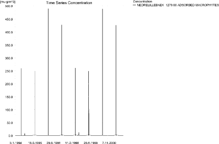
Figure 10.21. Concentration of rimsulfuron on macrophytes at the point of maximum concentration. The pattern follows the pattern of concentrations (in the water) in the stream.
Figur 10.21. Koncentration af rimsulfuron på makrofytter i punktet med maximumskoncentration. Mønsteret følger mønsteret for koncentrationer (i vandfasen) i vandløbet.
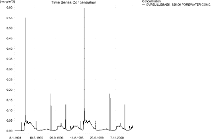
Figure 10.22. Concentration pattern of rimsulfuron in porewater in the sandy loam catchment. The highest concentration reached in a tributary is 0.86 ng/l and 0.61 ng/l in the main stream.
Figur 10.22. Koncentrationsmønster for rimsulfuron i porevand i morænelersoplandet. Den højeste koncentration opnået i et tilløb er 0.86 ng/l og i hovedvandløbet 0.61 ng/l.
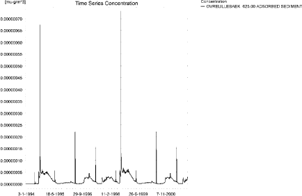
Figure 10.23. Concentration of rimsulfuron on sediment in the sandy loam catchment. The concentration is in µg/g sediment and not µg/m³ as stated. The maximum concentration of 0.75 ng/kg is reached upstream of this point.
Figur 10.23. Koncentration af rimsulfuron i sediment i morænelersoplandet. Koncentrationen er i µg/g sediment og ikke µg/m³ som angivet. Maximums-koncentrationen på 0.75 ng/kg opnås opstrøms for den viste lokalitet.
Compared to the FOCUS SW D4-stream, the maximum concentration of PestSurf is higher, 2.348 µg/l compared to 132 ng/l. The highest concentrations reached are caused by drift in both models, but drainage after an extreme event does cause high concentrations to occur in PestSurf. The sediment concentration calculated by FOCUS is 23 ng/kg, while PestSurf yields 0.75 ng/kg.
Figure 10.24, Figure 10.25, Table 10.9 and Table 10.10 show the results as generated by the PestSurf templates. The maximum value generated by the templates for the upper part of the stream is 864 ng/l, and for the lower part, 2.35 µg/l. The maximum value generated in the (upstream part of the) catchment is 1.06 µg/l and for the lower part, 2.35 µg/l. Thus, the templates did catch the maximum concentration of the PestSurf simulation.
Table 10.8. Maximum concentrations (ng/l) of rimsulfuron simulated for selected calculation point in the sandy loam catchment.
Tabel 10.8. Maximumskoncentrationer (ng/l) af rimsulfuron for udvalgte lokaliteter i morænelersoplandet.
Click here to see Figure 10.24.
Figure 10.24. Overview for rimsulfuron in the sandy loam catchment generated by the PestSurf excel template for the upstream part of the catchment. The detection value was set to 10 ng/l.
Figur 10.24. Oversigt for rimsulfuron genereret med PestSurf-excel-skabelonen for den opstrøms del af morænelersoplandet. Detektionsgrænsen var sat til 10 ng/l.
Click here to see Figure 10.25.
Figure 10.25. Overview for rimsulfuron in the sandy loam catchment generated by the PestSurf excel template for the downstream part of the catchment. The detection value was set to 10 ng/l.
Figur 10.25. Oversigt for rimsulfuron genereret med PestSurf-excel-skabelonen for den nedstrøms del af morænelersoplandet. Detektionsgrænsen var sat til 10 ng/l.
Table 10.9. Part of the result sheet generated by the PestSurf Excel sheet for the upstream part of the sandy loam catchment. The lowest detection value is 10 ng/l, toxicity to fish, daphnies and algae are set to 100, 1000 and 10000 ng/, respectively. The recorded peaks are shown in Figure 10.24.
Tabel 10.9. Uddrag af resultatpresentationen genereret af PestSurf-Excel-arket for den opstrøms del af morænelersoplandet. Detektionsgrænsen for tabelgenerering er sat til 10 ng/l. Toxicitetsværdierne for fisk, dafnier og alger er henholdsvis 100, 1000 og 10000 ng/l. Hændelserne er vist i Figur 10.24.
Table 10.10. Part of the result sheet generated by the PestSurf Excel sheet for the downstream part of the sandy loam catchment. The lowest detection value is 10 ng/l, toxicity to fish, daphnies and algae are set to 100, 1000 and 10000 ng/, respectively. The recorded peaks are shown in Figure 10.25.
Tabel 10.10. Uddrag af resultatpresentationen genereret af PestSurf-Excel-arket for den nedstrøms del af morænelersoplandet. Detektionsgrænsen for tabelgenerering er sat til 10 ng/l. Toxicitetsværdierne for fisk, dafnier og alger er henholdsvis 100, 1000 og 10000 ng/l. Hændelserne er vist i Figur 10.25.
Click here to see Table 10.10.
10.4.4 Sandy loam catchment, pond
The concentration pattern is evaluated in the middle of the pond only, see Figure 10.26. The pond receives contributions mainly drift, in good correspondence with the fact that it is situated in the upper part of the sandy loam catchment, but in wet periods, significant amounts of rimsulfuron arrives with drainage water. The maximum concentration is quite low, 22 ng/l.
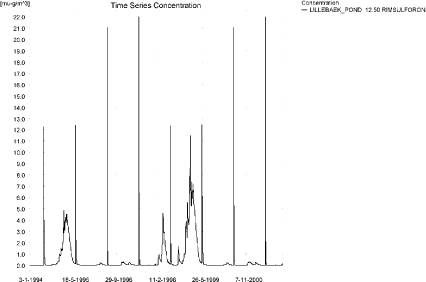
Figure 10.26. Concentrations of rimsulfuron for the sandy loam pond.
Figur 10.26. Koncentration af rimsulfuron i morænelersvandhullet.
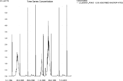
Figure 10.27. Rimsulfuron sorbed to the macrophytes in the sandy loam pond.
Figur 10.27. Rimsulfuron sorberet til makrofytter i morænelersvandhullet.
Figure 10.27 shows that the macrophytes participate in the regulation of the concentrations in the pond. The concentration level of 5.6 ng/l is significant compared to the concentrations in the water phase. The porewater concentration reaches 0.20 ng/l (Figure 10.28) and the concentrations in the sediment are shown in Figure 10.29. The maximum concentration reaches 0.27 ng/kg.
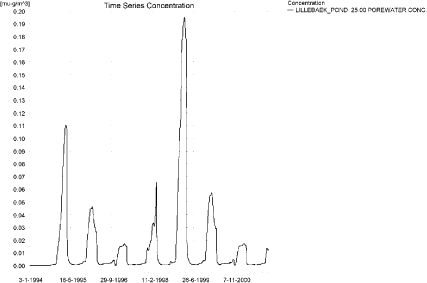
Figure 10.28.Pore water concentration of rRimsulfuron in the sandy loam pond.
Figur 10.28. Porevandskoncentration af rimsulfuron i morænelersvandhullet.
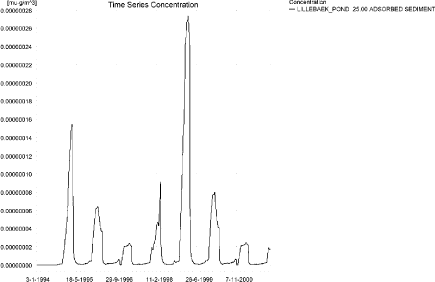
Figure 10.29. Rimsulfuron sorbed to sediment in the sandy loam pond. The concentration is in µg/g sediment and not µg/m³ as stated.
Figur 10.29. Rimsulfuron sorberet til sediment i morænelersvandhullet. Koncentrationen er i µg/g sediment og ikke µg/m³ som angivet.
In global maxima and time weighted concentrations (up to 7 days) were extracted.
Table 10.11. Actual and time weighted concentrations (ng/l) of rimsulfuron in the sandy loam pond.
Tabel 10.11. Beregnede og tidsvægtede koncentrationer (ng/l) af rimsulfuron i morænelersvandhullet.
| Year | Rimsulfuron | actual | Time-weighted | Date |
| 1994 | global max | 12 | 17-06-1994 | |
| 1 hour(after max) | 10 | 11 | ||
| 1 day after sp.in. | 7 | 8 | ||
| 3 days | 4 | 6 | ||
| 4 days | 3 | 5 | ||
| 7 days | 1 | 4 | ||
| 1995 | Global max | 12 | 17-06-1995 | |
| 1 hour | 11 | 11 | ||
| 1 day | 7 | 8 | ||
| 2 days | 4 | 6 | ||
| 4 days | 3 | 5 | ||
| 7 days | 1 | 4 | ||
| 1996 | global max | 21 | 17-06-1996 | |
| 1 hour | 18 | 19 | ||
| 1 day | 10 | 12 | ||
| 2 days | 4 | 9 | ||
| 4 days | 3 | 7 | ||
| 7 days | 1 | 5 | ||
| 1997 | global max | 22 | 17-06-1997 | |
| 1 hour | 18 | 20 | ||
| 1 day | 10 | 13 | ||
| 2 days | 4 | 9 | ||
| 4 days | 3 | 8 | ||
| 7 days | 1 | 5 | ||
| 1998 | global max | 12 | 16-06-1998 | |
| 1 hour | 11 | 11 | ||
| 1 day | 7 | 8 | ||
| 2 days | 4 | 6 | ||
| 4 days | 3 | 5 | ||
| 7 days | 1 | 4 | ||
| 1999 | global max | 12 | 16-06-1999 | |
| 1 hour | 11 | 11 | ||
| 1 day | 7 | 8 | ||
| 2 days | 4 | 6 | ||
| 4 days | 3 | 5 | ||
| 7 days | 1 | 4 | ||
| 2000 | global max | 21 | 16-06-2000 | |
| 1 hour | 18 | 19 | ||
| 1 day | 10 | 12 | ||
| 2 days | 4 | 9 | ||
| 4 days | 3 | 7 | ||
| 7 days | 1 | 5 | ||
| 2001 | global max | 22 | 16-06-2001 | |
| 1 hour | 18 | 20 | ||
| 1 day | 10 | 13 | ||
| 2 days | 4 | 9 | ||
| 4 days | 3 | 8 | ||
| 7 days | 1 | 5 | ||
| max values | ||||
| global max | 22 | |||
| 1 hour | 18 | 20 | ||
| 1 day | 10 | 13 | ||
| 2 days | 4 | 9 | ||
| 4 days | 3 | 8 | ||
| 7 days | 1 | 5 |
Figure 10.30 and Table 10.12 show output from the PestSurf template, with a time series identical to Figure 10.26.
The FOCUS SW-scenario D4-pond generates a concentration of 0.012 µg/l, which is quite close to the PestSurf sandy loam pond-concentration of 0.022 µg/l. The maximum concentration of FOCUS SW is reached through drainage, while the maximum value in PestSurf is reached through wind drift during a dry period. However, the drainage contribution is visible in the PestSurf simulation too. The higher drift contribution in PestSurf may be attributed to the smaller dimensions of the pond.
The FOCUS-calculation results in a sediment concentration of 7 ng/kg, while PestSurf produces 0.27 ng/kg in the sediment.
Click here to see Figure 10.30.
Figure 10.30. Overview for rimsulfuron in the sandy loam pond generated by the PestSurf excel template. The time series shown is identical to the one in Figure 10.26. The lowest detection value was set to 0.5 ng/l.
Figur 10.30. Oversigt for rimsulfuron i morænelersvandhullet genereret med PestSurf-excel-skabelonen. Den viste tidsserie er mage til den i Figur 10.26. Detektionsgrænsen er sat til 0.05 ng/l.
Table 10.12. Part of the result sheet generated by the PestSurf Excel sheet. The detection value is set to 0.5 ng/l. The toxicity values for fish, daphnies and algae were set to 10, 100 and 1000 ng/l, respectively. The recorded peaks are shown in Figure 10.30.
Tabel 10.12. Uddrag af resultatpresentationen genereret af PestSurf-Excel-arket. Detektionsgrænsen er sat til 1 ng/l. Toxicitetsværdierne for fisk, dafnier og alger er henholdsvis 10, 100 og 1000 ng/l. De tabellerede hændelser er vist i Figur 10.30.
Click here to see Tabel 10.12.
Table 10.13. Summary of simulation results for rimsulfuron.
Tabel 10.13. Opsummerede resultater for rimsulfuron.
Click here to see Tabel 10.13.
10.5 Summary of simulations
The maximum actual concentrations for all simulations are recorded in Table 10.13.
The concentration in the sandy pond is lower than for the D3-ditch, which is lower than for the sandy stream. The ditch-concentration is caused by wind drift, while the concentration in the sandy pond is caused by groundwater contribution. The sediment concentrations also differ, PestSurf reaching 1.8 ng/kg while FOCUS reaches 1.4 ng/kg. In both cases the figures are small.
The concentration in the sandy stream is strongly influenced by the fact that the whole agricultural area is sprayed within 30 minutes. This results in high concentrations. The maximum concentration reached 112 m from the upstream end is 64 ng/l, which is less than what is found in the D3 ditch (159 ng/l). The low concentration in PestSurf is, however, due to a combination of a buffer zone of 20 m width and a water depth of about 7 cm.
The concentration in the sandy loam pond is 22 ng/l, compared to 12 ng/l in the D4-pond. This difference can be explained by the difference in exposure between the ponds in the two systems.
Compared to the FOCUS SW-D4-stream, the maximum concentration of PestSurf is higher, 2.35 µg/l compared to 132 ng/l. The highest concentrations reached is caused by drift in both models, but drainage after the 20-year rain event does cause high concentrations to occur in PestSurf. The maximum concentration reached 125 m from the upstream end is 909 ng/l. The water depth at the time of spraying is about 4.5 cm, and the depth difference between the two models thus explains most of the difference. In addition, the PestSurf stream is triangular. The maximum concentration reached between 500 and 1700 m from the upstream end is 1.01 µg/l.
Macrophytes play a minor role for the concentration in the water phase in the sandy scenarios, but the role is significant for the sandy loam scenarios, because the concentration of macrophytes is considerably higher here than in the sandy scenarios.
Sediment concentrations are low in all simulations, but always higher in the FOCUS SW scenarios than in the PestSurf scenarios.
Version 1.0 December 2006, © Danish Environmental Protection Agency