Evaluation of Pesticide Scenarios for the Registration Procedure
5. New Model Scenarios for the Registration Procedure of Pesticides
- 5.1. Selection of New Model Scenarios
- 5.2. Description of Themes included in the Standard of Reference
5.1. Selection of New Model Scenarios
As background for the selection of a new model scenario for pesticide approval respectively for a sandy and clayey soil among the 4 sandy sites (Karup, Hamburg, Tylstrup, and Jyndevad) and clayey sites (Langvad, Silstrup, Estrup, and Faardrup), a standard of reference is establish, Table 8. The standard of reference includes a characterisation of all the scenarios with regard to observation in relation to precipitation, geology, and reliability of field data and conceptual model (Theme A-F in Table 8) and the leaching results of the MACRO-simulations presented in this report (Theme G-I in Table 8). In this connection it should be emphasised that the geological themes B-D’s influence of pesticide leaching are unknown. The standard of references is summarised in Table 8, whereas a detailed description of the individual themes, and why they are chosen as themes, is given in section 5.2.
Based on this standard of reference, the Jyndevad and the Silstrup are recommended as the new model scenarios for sand and clay, respectively. This recommendation is based on the following evaluation of the standard of reference:
The Jyndevad scenario represents the sand-scenario with the highest observed average precipitation and highest degree of simulated A, B, and C-leaching. Additionally Jyndevad represents a ‘Moorland Plain’ with topsoil similar to about 24% of the topsoils covering Denmark. The surface geology of Jyndevad is characterised by ‘Glaciofluvial sand and gravel’, which only represents 2% of the surface geology of Denmark. By choosing the Karup scenario instead of the Jyndevad scenario, the surface geology of Denmark will be represented by 10%, however the reliability of the field data and conceptual model behind this scenario is low. The same lack of reliability is present for the Hamburg scenario, added with no information concerning the geological environment beside sparse texture information. The Tylstrup scenario has as reliable field data and conceptual model as the Jyndevad scenario, though it represents Yoldia Beds, which only covers 2% of the land surface of Denmark. According to Greve et al. (2007), the spatial variation in texture on a ‘Yoldia Bed’ is much higher than for other element. Given this high spatial variation, an increased uncertainty in the simulated leaching of the Tylstrup scenario could be introduced given that it is based on a one dimensional conceptual model.
The Silstrup scenario represents the clay-scenario with the second highest observed average precipitation and a high degree of simulated A, B, and C-leaching. Additionally, Silstrup represents a ‘Terminal Moraine Landscape’ with topsoil, which has the same soil type as only 5% of the topsoils covering Denmark. The surface geology of Jyndevad is like the other clay-scenarios characterised by ‘Till clayey and fine sandy’, which represents 38% of the surface geology of Denmark. If choosing the Langvad scenario instead of the Silstrup scenario, the soil type of the topsoil of Denmark will be represented by 28%, however the reliability of the field data and conceptual model behind this scenario is low. The Faardrup scenario has as reliable field data and conceptual model as the Silstrup scenario, though it represents the lowest observed average precipitation, the lowest degree of simulated A, B, and C-leaching, and hereby not a worst case scenario. Contrary, the Estrup has the highest observed average precipitation and a high degree of simulated A, B, and C-leaching. However being a ‘Hill Island’, which according to Greve et al. (2007) is characterised by large spatial variation in texture, an increased uncertainty in the simulated leaching of the Estrup scenario could be introduced given that it is based one dimensional conceptual model. Given errors in the TDR-measurements, the reliability of the field calibration data and conceptual model of Estrup is slightly lower than at e.g. Silstrup.
| Sand scenarios | Clay scenarios | |||||||
| Theme | Karup | Hamburg | Tylstrup | Jyndevad | Langvad | Silstrup | Estrup | Faardrup |
| BASED ON OBSERVATIONS | ||||||||
| A. Average precipitation (mm) | 912 | 786 | 850 | 1024 | 675 | 915 | 1032 | 653 |
| B. Surface geology and its represen- tativity (%). |
Down- wash sandy deposits 10% |
? | Glacio- marine clay, silt, and sand 19% |
Glacio- fluvial sand and gravel 2% |
Till clayey and fine- sandy 38% |
Till clayey and fine- sandy 38% |
Till clayey and finesandy 38% |
Till clayey and fine-*sandy 38% |
| C. Soil type of topsoil and its represen- tativity (%) |
JB3 - 9% | JB4 - 19% | JB2 - 8% | JB1 - 24% | JB5/6 - 28% | JB7 – 5% | JB5/6 - 28% | JB5/6 - 28% |
| D. Element of the landscape and its represen- tativity (%). |
Moorland Plain 11% |
? | Yoldia Beds 2% |
Moorland Plain 11% |
Younger Moraine Land- scape ~30% |
Terminal Moraine Land- scape ~30% |
Hill Islands 11% |
Younger Moraine Land- scape ~30% |
| E. Reliability of field data (Quality; Quantity). | (+; +) | (+; +) | (+++; ++) | (+++; ++) | (+; +) | (+++; +++) | (+++; ++) | (+++; +++) |
| F. Reliability of conceptual model (Water Balance; Mass Balance of bromide). |
(+; - ) | (+; - ) | (++; ++) | (++; ++) | (+; - ) | (+++; +++) | (++; ++) | (+++; +++) |
| BASED ON SIMULATIONS | ||||||||
| G. Degree of simulated pesticide A leaching. Spring application (1 m b.g.s.; 3 m b.g.s.; Drain). Fall application (1 m b.g.s.; 3 m b.g.s.; Drain). Number of annual pesticide concen- trations 1 m b.g.s. ≥ 0.1 μg/l - Spring/Fall. 3 m b.g.s. ≥ 0.1 μg/l - Spring/Fall. |
(+++; - ; - ) (+++; - ; - ) 20/20 ? |
(+++; - ; - ) (+++; - ; - ) 20/20 ? |
(+++; +++ ; -) (+++; +++; - ) 20/20 20/20 |
(+++; +++ ; -) (+++; +++; - ) 20/20 20/20 |
(+++; - ; + ) (+++; - ; + ) 20/20 ? |
(+++;+ ++;++) (+++; +++; +++) 20/20 20/20 |
(+++;+ ++;++) (+++; +++; +++) 20/20 20/20 |
(+++; +++;+) (+++; +++;+) 20/20 17/20 |
| H. Degree of simulated pesticide B leaching. Spring application (1 m b.g.s.; 3 m b.g.s.; Drain). Fall application (1 m b.g.s.; 3 m b.g.s.; Drain). Number of annual pesticide concen- trations 1 m b.g.s. ≥ 0.1 μg/l - Spring/Fall. 3 m b.g.s. ≥ 0.1 μg/l - Spring/Fall. |
(+; - ; - ) (+; - ; - ) 0/20 ? |
(+; - ; - ) (+; - ; - ) 0/6 ? |
(+; + ; - ) (++; +; - ) 0/6 0/0 |
(++; ++ ; - ) (+++; +++; - ) 1/20 1/20 |
(++; - ; + ) (+++; - ; + ) 6/20 ? |
(++; ++ ; + ) (+++;+ ++;++) 14/20 13/20 |
(++;+ +;+) (+++; +++; +++) 14/20 8/20 |
(+;+;+) (++; ++;+) 0/8 0/5 |
| I. Degree of simulated pesticide C leaching. Spring application (1 m b.g.s.; 3 m b.g.s.; Drain). Fall application (1 m b.g.s.; 3 m b.g.s.; Drain). Number of annual pesticide concen- trations 1 m b.g.s. ≥ 0.1 μg/l - Spring/Fall. 3 m b.g.s. ≥ 0.1 μg/l - Spring/Fall. |
(+; - ; - ) (+; - ; - ) 0/20 ? |
(+; - ; - ) (+; - ; - ) 0/20 ? |
(+; + ; - ) (+; +; - ) 0/0 0/0 |
(+++; +++;-) (+++; +++;-) 20/20 18/20 |
(++;- ;+) (+++;- ;+) 20/20 ? |
(+++;++ +;++) (+++;++ +;++) 20/20 20/20 |
(+++;+ ++;++) (+++;+ +;++) 20/20 15/10 |
(+;+;+) (+;+;+) 0/0 0/0 |
Table 7. Standard of reference - a characterisation of all the scenarios with respect to precipitation, geology, reliability of field data/conceptual model, and simulated pesticide leaching
5.2. Description of Themes included in the Standard of Reference
The themes A-I included in the standard of reference, Table 8, are chosen within two categories: ‘Based on observations’ and ‘Based on simulations’. The category ‘Based on observations’ is included to emphasis the need of getting well-characterised scenarios as model scenario for pesticide approval. To evaluate the outcome of the MACRO-simulations it is important to be aware of the climatic and geological environment of the chosen scenarios.
The first Theme A is the average precipitation of the scenarios. The geographical variation in precipitation across Denmark, Figure 12., needs to be taken into account when selecting scenarios for pesticide approval. Areas with the highest mean annual precipitation and hereby a higher leaching risk are located in the Western part of Denmark, wherefrom there is a reduction in the mean annual precipitation of up to several hundreds millimetre going East. Langvad and Faardrup therefore represent the lowest average precipitation. The yearly precipitation of the 8 scenarios in question are within the range of approximately 400-1400 mm, Figure 12., and the simulated yearly net precipitation is within the range of approximately 20-900 mm, Figure 4.
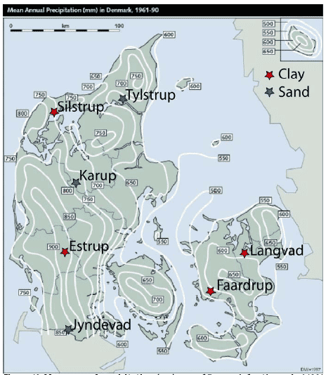
Figure 12. Mean annual precipitation (mm) map of Denmark for the period 1961-1990 (Frich et al., 1997) with the location of the Danish sand scenarios (Karup, Tylstrup and Jyndevad) and clay scenarios (Langvad, Silstrup, Estrup, and Faardrup).
Theme B is addressing the surface geology of the scenarios and its representativity. A representative surface geology map for respectively the Danish sand and clay scenarios are given in Figure 13. The map provides large scale information concerning genetic facies 1 m b.g.s., which renders expectations to soil property above 1 metre and hereby interpretation to hydraulic conditions and presence of chalk/humus/fractures/biopores.
The Danish scenarios broadly represent the Danish surface geology. The three sand scenarios Karup, Tylstrup, and Jyndevad represent three different surface geology in the given order: ‘Downwash sandy deposits’, ‘Glaciomarine clay, silt and sand’, and ‘Glaciofluvial sand and gravel‘, which cover respectively approximately 10%, 2%, and 19% of Denmark’s land area – A variation, which needs to be taken into account in the selection of the new sand-model-scenarios for pesticide approval. The four clay scenarios Langvad, Silstrup, Estrup and Faardrup all represent the same surface geology ‘Till, clayey and fine-sandy’, which covers ~38% of Denmark’s land.
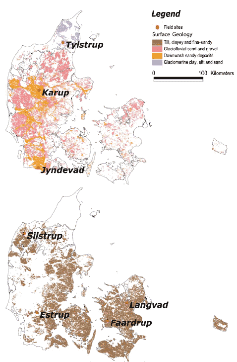
Figure 13. Representative surface geology maps for respectively the Danish sand scenarios (Karup, Tylstrup and Jyndevad) and clay scenarios (Langvad, Silstrup, Estrup, and Faardrup) included in this work. These maps are based on the Geological Survey of Denmark and Greenland’ digital map of the surface geology of Denmark, 1:25.000 (see www.geus.dk).
Theme C concerns the soil type of the topsoil of the scenarios and its representativity, Figure 14. The texture of the topsoil is very important for the amount of pesticides leaching through the soil, since the protection offered by the subsoil layers are considered to be low for most pesticides, due to the very low microbial activity, sorption and degradation generally found in these layers (Aamand et al., 2004). Iversen et al. (2006) have described the leaching risk of pesticides in sandy-soil in relation to its texture, which showed an increase in MACRO simulated leaching risk with a decreasing humus, and clay+silt content. For that reason it is important to incorporate the knowledge concerning the soil texture of the top soil in the selection of new model-scenarios.
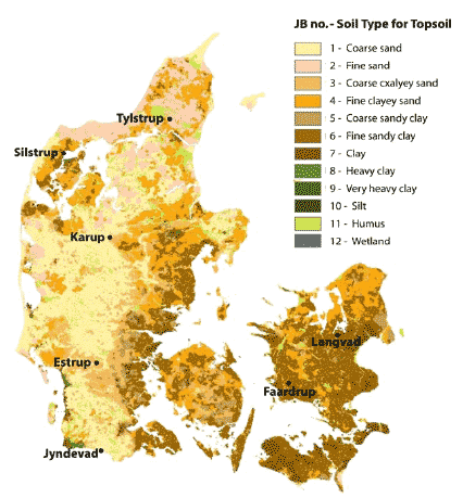
Figure 14. The Danish Institute of Agricultural Sciences’ nationwide topsoil property map of Denmark. The map is based on the texture classes (JB-numbers) of the Danish Soil Classification (Greve et al., 2005).
Theme D is the element of landscape of the scenarios and its representativity (Madsen et al., 1992). The map of the elements of the landscape illustrates the distribution of genetic facies at large scale and hereby renders expectations to soil properties in areas not covered by other geological data. This includes e.g. interpretation on hydraulic properties and presence of humus/fractures/biopores.
Figure 15 shows the different element of the Danish landscape and the element of landscape that each of the eight scenarios represent is given in Table 8. Results from the KUPA-project show that the element of landscape like ‘Yoldia Beds’ (Tylstrup scenario) and ‘Hill Island’ (Estrup scenario) give rise to a large variation within the texture (Greve et al., 2007). Given this variation, the representativeness of a conceptual 1-D model based on 3-D field observations gives rise to a large uncertainty.
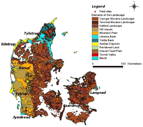
Figure 15. The Danish Institute of Agricultural Sciences’ map on Element of the landscape added locations of Danish sites representing the scenarios: Karup, Tylstrup, Jyndevad, Langvad, Silstrup, Estrup, and Faardrup.
Theme E addresses the reliability of field data in relation to quality and quantity, which is essential for setting up realistic conceptual models for simulating pesticide leaching. The reliability is categorised into three groups describing both quality and quantity of available field data. Quantity “+”, “++” and “+++” refers to minimal, medium and large data availability, respectively. Likewise for quality where “+”, “++” and “+++” refers to low, medium and high data quality, respectively. In the PLAP-project, field data of high quality is collected during a 5 years period, Appendix C. At the two sand scenarios of PLAP (Tylstrup and Jyndevad), less information is available concerning the overall water and the mass balance, given that no data on water fluxes are present and only point measurement are obtained. For the three clay scenarios of PLAP (Silstrup, Estrup, and Faardrup), detailed drain information provides venerable information on water fluxes, why a calibration against these field data provides a more reliable conceptual model. In Estrup, some TDR-data errors are present resulting in a less reliable conceptual model than for Silstrup and Faardrup. Compared to the PLAP scenarios, the field data behind Hamburg, Karup and Langvad seems to be minimal both in quality and quantity.
Theme F is linked directly to theme E and addresses the reliability of the conceptual models. Given the varying quality and quantity of field data for the eight scenarios, the reliability of conceptual models for the scenarios is varying a lot. For the PLAP-scenarios, the calibration results are shown in Appendix C and summarised in Table C1, which illustrate how well the final conceptual model is performing compared to the direct field measurements. The conceptual models behind the Hamburg, Karup and Langvad scenarios are not calibrated against any direct field measurements, why the reliability of these models is minimal.
Theme G-I addresses the degree of simulated leaching of the eight scenarios applying the three pesticides (A, B and C). Based on the results presented in section 3.3.2 - 3.4 the average yearly leaching is ranked in following three categories:
+ Pesticide concentration < 0.01 μg/l,
++ Pesticide concentration < 0.1 μg/l and >0.01 μg/l,
+++ Pesticide concentration ≥ 0.1 μg/l,
Results are presented separately for spring and fall application in respectively 1 m b.g.s., 3 m b.g.s., and drains. Additionally, the number of annual pesticide concentrations at 1 and 3 m b.g.s. equal or larger than maximum allowed concentration for respectively the spring and the fall application is given in the format of 18/20 (spring/fall).
Version 1.0 August 2007, © Danish Environmental Protection Agency