[Front page] [Contents] |
Manual for program til risikiovurdering -
JAGG (Jord, Afdampning, Gas, Grundvand)
Summary
At the end of 1998 the Danish Environmental Protection Agency issued guidelines for ”Remediation of contaminated sites”. These guidelines deal with the risk assessment of soil, groundwater and vaporisation of soil contaminants and their migration to outdoor and indoor air.
The Danish Environmental Protection Agency has recently developed a PC-based spreadsheet (in Danish called JAGG - Jord, Afdampning, Gas, Grundvand) that will facilitate work connected to risk assessment. This user-friendly spreadsheet can be used to carry out risk assessments of contaminated soil in relation to a groundwater resource and the vaporisation of contaminants to indoor and outdoor air.
Risk assessment tool
Background and objective
In December 1998 the Danish Environmental Protection Agency issued guidelines for
"Remedial works on contaminated sites". These guidelines comprise six volumes:
one main volume, one appendix and four specific sections.
The guidelines represent an update, extension and clarification of the 1992 guidelines from the Danish Environmental Protection Agency. The guidelines describe the handling of contaminated sites from the examination phase to any potential remedial works. A key section of the guidelines deals with risk assessment of contaminated soil in relation to land use, groundwater and evaporation. To facilitate calculation routines involved in risk assessment and to provide the option of graphical presentation of the assessment, the Danish Environmental Protection Agency decided to develop a spreadsheet.
Development of the spreadsheet
The spreadsheet has been designed for a Danish version of Excel 97 and will run with adequate performance on a computer with an Intel Pentium 166 MHz processor and 32 MB of RAM.
The spreadsheet has been programmed in Visual Basic. When the program is running it invokes a number of formulae, macros and hidden spreadsheets. For a more technical description please consult the software manual.
The program facilitates risk assessment of contaminated sites
Main conclusions
The spreadsheet can be used to carry out risk assessment of contaminated sites on the basis of the procedure described in the guidelines for the Remediation of Contaminated sites. The spreadsheet has a userfriendly setup requiring minimal computer knowledge. Data is easily entered into the various selection tables and the spreadsheet is designed with menus containing a variety of click-on topics.
In the spreadsheet, the physical-chemical data and limit values for soil, groundwater and evaporation to air are stated for numerous contaminating substances. In addition, each screen image displays a help facility and the possibility to view and print various intermediate calculations. Finally, a graphical presentation of the risk assessment is available.
The program contains the following menu pages:
- Fugacity calculations, i.e. calculation of equilibrium concentrations between gas, soil and water phases, respectively
- Evaporation to indoor or outdoor air
- Gas production and convective migration of gas from waste disposal sites (landfill gas)
- Risk assessment of diffused soil contamination in relation to land use
- Risk assessment of contamination in relation to groundwater resource
- Migration of contamination in unsaturated zone
- Calculation of the probability of locating contaminated soil
Spreadsheet with eight menus
Project results
The spreadsheet is designed with 8 menu pages, selectable from the front page of the program. The main content of the individual menus is described as follows:
Assessment of diffused soil contamination
In the case of diffused soil contamination, the calculations may be used to determine whether a site is acceptable for very sensitive land use such as house gardens or playgrounds in kindergartens. A distinction is made between two approaches, depending upon the properties of the contaminating substance:
- Contamination with a substance where the chronic effect has been decisive for determining the soil quality criterion, or
- contamination where the acute effect was the decisive factor for determining the soil quality criterion.
Vaporisation to outdoor air
A conservative calculation of the diffusive transport of pore gas from a contaminated area to the surface of the soil and the subsequent mixing with outdoor air.
The calculations are made on the basis of measured or calculated pore gas concentrations, soil parameters and knowledge of the size of the contaminated area.
Vaporisation to indoor climate
The spreadsheet may also be used for a conservative calculation of the diffusive transport of contamination of the soil pore gas from a contaminated area to the lower side of the floor in a house. The transportation of contaminating substances into the house may be calculated as the sum of the diffusive and convective transport.
Calculations are made on the basis of pore gas concentrations, soil parameters and available data on the buildings and floors. Chemical parameters and various building data have been included in the spreadsheet as standard parameters.
The equations used in the calculations have been derived assuming reinforced concrete floors but calculations can also be made for plain concrete floors if the relevant lengths and widths of fissures in the floor are known.
Landfill gas
The spreadsheet can calculate the annual rate of gas production on the basis of half time values and total gas production, which depend on the residual type.
It is possible to calculate the relationship between pore gas concentrations of the landfill and the indoor-air concentration in a building placed outside the landfill on the basis of the convection model, which is stated in the guidelines. The calculations also provide the pressure gradient and time necessary to establish equilibrium.
The calculations represent a worstcase scenario, i.e. where the topsoil is frozen and water-saturated and where all gas from the landfill is transported out and into the building in question.
Risk assessment in relation to groundwater
The spreadsheet performs a risk assessment that is subdivided into three steps that are specified individually.
- Step 1
- is a "Mixing model close to the source area", where the infiltrating contaminated pore water is mixed with groundwater in a 0.25 m wide verticalzzone of the top of the aquifer, immediately under the source of contamination.
- Step 2
- is a "Mixing model downstream of the source area" where the thickness of the vertical zone in the aquifer is determined on the basis of the distance corresponding to 1 yr. of groundwater travel time with a maximum of 100 metres from the source area. The principle that is the longer the groundwater flows, the greater the mixing zone thickness becomes, leading to a lower concentration of contamination
- Step 3
- "Downstream model based on dispersion, sorption and natural degradation" includes the effect of sorption and degradation of contaminants in the aquifer considered. As it is difficult to predict the rate of degradation, monitoring should always take place on site in order to determine the specific degradation rate. On the basis of the monitoring data the program can calculate the actual rate of degradation.
An example of plots of the calculated concentrations of contamination at the three steps is shown in Figure 1 (in Danish).
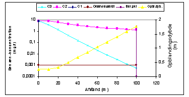
Figure 1. Graphical presentation of the calculated concentrations of contamination in the groundwater as a function of distance. Ci indicates the concentration of contamination calculated at step 1 of the risk assessment.
Fugacity calculations
In the principle of fugacity, equilibrium is assumed between the distribution of contamination in soil, water and air phases. Based on chemical table values the maximum content of contamination in the three phases can be calculated. Assuming that the same relationship exists between the phases at lower concentrations, the concentration in pore gas and pore water may be calculated if the soil contaminant concentration is known.
Input data for the spreadsheet includes a contamination component and soil type, possibly by means of one of the many selection tables available in the program.
Migration in unsaturated zone
The spreadsheet also provides an opportunity to calculate the migration of substance by means of pore water transportation through the unsaturated zone. Here the pore water concentration may be calculated as a function of time and depth.
As it is currently impossible to give more than an incomplete description of the migration of contamination in unsaturated zone the results obtained must be considered with great reservation. In addition concentrations, and especially "breakthrough times" should only be regarded as trends. The spreadsheet can distinguish between pulse contamination e.g. due to an incident action and continuously contamination e.g. due to leaching from a landfill site.
Probability
Finally, it is possible to calculate the probability of encountering contamination at a given site where the diameter of a hot spot or the percentage of the contaminated site is known and where the number of places where samples are taken is given in advance.It is a prerequisite for the calculations that the contaminated site can be assumed having the form of a vertical cylinder, and that samples in the borings are taken with at least the same length interval as the presumed thickness of the contamination.
Figure 2 shows a screen image with input data and results (in Danish).
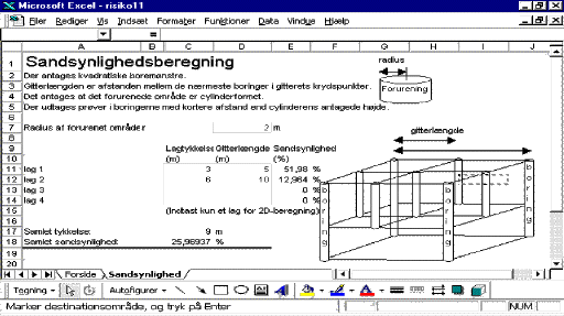
Figure 2. Calculation of probability. Screen image with input data (white fields) and results
|
|
[Front page] [Contents] [Top] |