Evaluation of Pesticide Scenarios for the Registration Procedure
2. Presentation of Scenarios
- 2.1. Overview of all scenarios
- 2.2. History and Description of Present Scenarios
- 2.3. History and Description of the PLAP Scenarios
- 2.4. Calibration and Validation
The chapter presents an overview of yearly climatic conditions and central soil and hydraulic parameters of the eight scenarios used in the analysis: The two original model scenarios Langvad and Karup, the EU scenario Hamburg, and the five PLAP scenarios Tylstrup, Jyndevad, Silstrup, Estrup and Faardrup (Figure 1). Furthermore it states the stage of calibration/validation and gives the history and a more detailed description of each scenario.
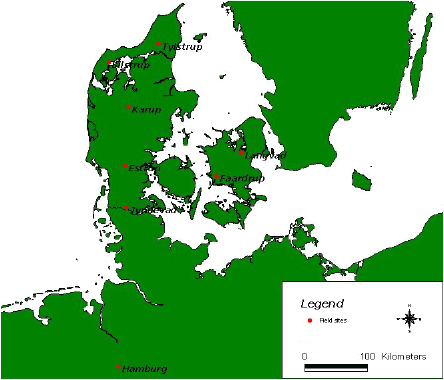
Figure 1. Geographical location of field sites representing the not official EU-FOCUS-scenario Langvad and Karup, the EU-FOCUS-scenario Hamburg and the PLAP scenarios Tylstrup, Jyndevad, Silstrup, Estrup and Faardrup.
2.1. Overview of all scenarios
Organic matter, clay, and silt content in A, B, and C horizons for the sand and clay scenarios are illustrated in Figure 2. The values behind the figure added with other physical properties for the soils are given in Table1 and Table 2. The values are for most of the scenarios based on a more detailed data set, Appendix A, B, and C.
Organic matter, reaching 2.9% in sandy top soils and 4.1% in loamy topsoil, is decreasing with depth for all scenarios,
. The sandy scenarios have clay content less than 8% with small deviations for all horizons, and silt content with larger deviations ranging between 0.0-26.3%. At the clay scenarios, the horizons have 14% - 28% clay and 18% - 40% silt.
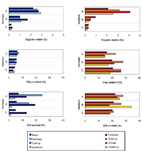
Figure 2. Organic matter, clay, and silt content in A, B, and C horizons for sand scenarios (left) and clay scenarios (right). The values of the PLAP-scenarios represent the average values used in the model set up.
An overview of climatic conditions for the eight scenarios is given in Figure 3, which shows maximum, minimum, and average yearly precipitation, actual evapotranspiration, and calculated net precipitation for each location for the studied 20-years period. Average precipitation varies between 650 and 1050 mm/year, with the lowest values for the two scenarios Langvad and Faardrup located in the eastern part of Denmark. Average actual evapotranspiration ranges between 400 – 550 mm/year, with the highest actual evapotranspiration at Jyndevad and hereafter Hamburg. Potential evapotranspiration is unfortunately not available for all scenarios, why the actual evapotranspiration that has been calculated for spring cereals in each scenario is shown in the figure. It is noted that the actual evapotranspiration of the clay scenarios (Langvad, Silstrup, Estrup, and Faardrup) calculated by MACRO have the same overall level, which is not the case for the sand scenarios (Karup, Tylstrup, and Jyndvad). Since geographical variation in the potential evapotranspiration is minimal (Kjær et al., 2005), this difference in simulated actual evapotranspiration for sand/clay scenarios seems to be related to the depth to and fluctuations of the groundwater table, and the root depth. The groundwater tables of the clay PLAP scenarios fluctuate generally between 1 and 4 m b.g.s. minimizing the root depth, whereas fluctuations of 1 metre are observed at the sand PLAP scenarios leaving the maximum level of the groundwater table, which is 3 and 1 m b.g.s. at respectively Tylstrup and Jyndevad, to be a controlling parameter. Yearly net precipitation (precipitation minus actual evapotranspiration) ranges between 25-1000 mm/year and average net precipitation varies between 250 mm/year at Faardrup and 650 mm/year at Estrup.
Table 1. Overview of physical properties for the sand profiles. For more detailed information see Appendix A, B, and C.
| Profile | Horizon | Depth (cm) |
Clay* (%) |
Silt* (%) |
Sand* (%) | OM (%) |
Bulk density (g/cm³) |
Porosity (%) |
Ks (m/s) |
| Karup | |||||||||
| A | 0-20 | 6.0 | 7.0 | 87.0 | 2.20 | 1.51 | 42 | 6.0e-5 | |
| B | 20-40 | 5.5 | 5.5 | 89.0 | 1.74 | 1.55 | 42 | 3.5e-5 | |
| B | 40-70 | 5.5 | 5.5 | 89.0 | 0.30 | 1.55 | 42 | 3.5e-5 | |
| C | 70- | 4.2 | 4.8 | 91.0 | 0.20 | 1.53 | 42 | 2.0e-4 | |
| Hamburg | |||||||||
| A | 0-30 | 7.2 | 24.5 | 68.3 | 2.6 | 1.50 | 39 | 2.3e-5 | |
| B | 30-60 | 6.7 | 26.3 | 67.0 | 1.7 | 1.60 | 37 | 3.2e-5 | |
| B | 60-75 | 0.9 | 2.9 | 96.2 | 0.3 | 1.56 | 35 | 2.8e-5 | |
| C | 75-200 | 0.0 | 0.1 | 99.9 | 0.0 | 1.61 | 31 | 2.8e-5 | |
| Tylstrup | |||||||||
| A | 0-32 | 6.4 | 12.9 | 80.7 | 2.7 | 1.40 | 47 | 7.0e-7 | |
| B | 32-93 | 5.5 | 19.2 | 75.3 | 1.7 | 1.42 | 47 | 5.0e-6 | |
| C | 93-160 | 3.1 | 13 | 83.9 | 0.3 | 1.51 | 43 | 2.5e-5 | |
| Jyndevad | |||||||||
| A | 0-31 | 5.3 | 4.2 | 90.5 | 2.9 | 1.40 | 47 | 3.5e-5 | |
| B | 31-95 | 5.0 | 2.0 | 93.0 | 1.1 | 1.45 | 45 | 1.3e-4 | |
| C | 95-150 | 4.0 | 1.5 | 94.5 | 0.2 | 1.50 | 43 | 2.5e-4 |
*For Tylstrup and Jyndevad: Clay:<2 μm; Silt: 2-50μm; Sand: 50–2000 μm. For Hamburg and Karup the intervals are not defined; OM: Organic matter determined as 1.72 · total organic carbon;
Ks: Saturated hydraulic conductivity. At Tylstrup and Jyndevad determined based on measurements for small soil cores (Iversen et al., 2001) from a couple of profiles. For Karup and Hamburg no information about sample size and number is available.
Table 2. Overview of physical properties for the clay profiles. For more detailed information see Appendix A and C.
| Profile | Horizon | Depth (cm) |
Clay* (%) |
Silt* (%) |
Sand* (%) | OM (%) |
Bulk density (g/cm³) |
Porosity (%) |
Ks (m/s) |
| Langvad | |||||||||
| A | 0-20 | 16.0 | 22.0 | 62.0 | 2.10 | 1.50 | 45 | 2.5e-5 | |
| B | 20-40 | 20.0 | 21.0 | 59.0 | 1.42 | 1.65 | 36 | 1.0e-4 | |
| B | 40-70 | 20.0 | 21.0 | 59.0 | 0.50 | 1.65 | 36 | 1.0e-4 | |
| C | 70- | 20.6 | 20.0 | 59.4 | 0.26 | 1.76 | 34 | 7.2e-6 | |
| Silstrup | |||||||||
| A | 0-30 | 22.5 | 27.7 | 49.8 | 3.1 | 1.48 | 44 | 3.5e-6 | |
| B | 30-95 | 27.9 | 26.2 | 45.9 | 0.5 | 1.61 | 40 | 2.4e-5 | |
| C | 95-190 | 26.3 | 20.9 | 52.8 | 0.2 | 1.75 | 34 | 2.0e-7 | |
| Estrup | |||||||||
| A | 0-27 | 14.6 | 23.3 | 62.1 | 4.1 | 1.51 | 43 | 3.5e-6 | |
| B | 27-55 | 21.7 | 17.9 | 60.4 | 0.5 | 1.68 | 36 | 8.0e-8 | |
| C | 55-150 | 26.3 | 18.2 | 55.5 | 0.3 | 1.64 | 38 | 3.0e-8 | |
| Faardrup | |||||||||
| A | 0-32 | 14.6 | 25.0 | 60.4 | 2.5 | 1.51 | 41 | 2.3e-6 | |
| B | 32-110 | 17.0 | 33.9 | 49.1 | 0.3 | 1.67 | 37 | 1.2e-5 | |
| C | 110-185 | 18.7 | 27.0 | 54.3 | 0.2 | 1.82 | 32 | 8.2e-7 |
*For Silstrup, Estrup and Faardrup: Clay:<2 μm; Silt:2-50μm; Sand: 50–2000 μm. For Langvad the intervals are not defined; OM: Organic matter determined as 1.72 · total organic carbon;
Ks: Saturated hydraulic conductivity. At Silstrup, Estrup, and Faardrup determined based on measurements for small soil cores (Iversen et al., 2001) from a couple of profiles. For Langvad no information about sample size and number is available.
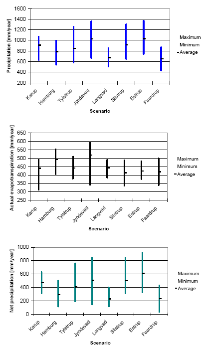
Figure 3. Maximum, minimum, and average yearly precipitation, actual evapotranspiration, and net precipitation for all locations for the 20-years period used in the simulations. Evapotranspiration is calculated for spring cereals. Net precipitation is calculated as precipitation minus actual evapotranspiration for spring cereals.
2.2. History and Description of Present Scenarios
2.2.1. Karup and Langvad Scenarios
The Karup and Langvad scenarios are the first model scenarios used in the Danish pesticide leaching approval system. They have been applied since 1998. The scenarios represent two typical Danish catchments investigated as a part of the Danish NPO-Research Programme (Storm et al., 1990), and reflect respectively the specific Western and Eastern type of combinations of soil types and climatic conditions found in Denmark. The two scenarios were originally set up in the numerical one-dimensional model MACRO 4.0 and later upgraded to MACRO 4.4.2. (FOCUS, 2000) and added in the FOCUS-setting without including them as FOCUS-scenarios. MACRO 4.4.2. contains the most advanced flow description of the model codes used in FOCUS as it includes preferential flow, but surface runoff and volatilisation are not represented. Additionally, MACRO 4.4.2. and most recent version MACRO 5.1. do not incorporate the possibility of simulating metabolite migration simultaneously with the parent compound making it less efficient and user friendly with regards to simulation of metabolite leaching.
The Karup scenario represents the Karup Å catchment located in West Jutland. Karup consists mainly of sandy soil types, and average precipitation and net recharge amount to 850 mm/y and 400 – 600 mm/y respectively, Figure 3 . The Langvad scenario represents the Langvad Å catchment located in East Sealand. The catchment consists of loamy moraine clay soils with topsoil of sandy loam, and the average precipitation and net recharge amount to 650 mm/y and 2000 mm/y respectively (Miljøstyrelsen, 1998). Yearly climatic conditions and soil and hydraulic properties for the two scenarios are summarised in Figure 2-3 and Table 2, whereas further information on data availability and model parameterisation is given in Appendix A. It is noted that precipitation and potential evaporation in the MACRO 4.4.2 setup of Karup and Langvad are only based on data from 1974 to 1993 and not from 1968 to 1996 as showed in Appendix A.
2.2.2. Hamburg Scenario
Many model runs have already been performed in the EU registration process. To facilitate the evaluation and minimise the model work especially with regard to metabolite calculations, the Danish EPA compared results from the nine FOCUS scenarios with results from the two Danish scenarios or at least with the Danish sandy scenario Karup. According to the Danish EPA this comparison showed quite similar results for Karup and the FOCUS Hamburg scenario. Given that the Hamburg scenario represents a German worst case groundwater scenario, and is geographically close to Denmark with comparable soil and climate data, the Danish EPA decided to accept modelling based on the Hamburg scenario (with the specified Danish input and output percentiles). The scenario is included in the group of FOCUS-scenarios and is setup in the numerical one- dimensional model code PELMO 3.2, which describes water flow in the soil in a rather simple manner (tipping bucket), but includes descriptions of surface runoff and volatilisation, and allows efficient and user friendly calculations for compounds with up to eight metabolites (FOCUS, 2000).
The Hamburg scenario is based on the national German scenario (reflecting soil properties and parameters at a field site situated at Borstel by Neustadt am Rübenberge), which is based on a soil survey intended to locate a worst case leaching soil. The scenario represents a sandy soil with an annual precipitation within the range of approximately 600 to 1000 mm/year. Vulnerability associated with this soil significantly exceeds the target of an 80th percentile soil (Kördel et al., 1989). An overview of yearly climatic conditions and soil and hydraulic properties for the scenario has been shown at the beginning of this chapter. Further information on data availability and model parameterisation is given in Appendix B.
2.3. History and Description of the PLAP Scenarios
In 1998, the Danish Parliament initiated the Pesticide Leaching Assessment Programme (PLAP). The objective of PLAP is to improve the scientific foundation for decision making in the Danish registration procedures for pesticides used in arable farming and hereby provide an early warning system for unacceptable leaching. The work was conducted by GEUS, the Danish Institute of Agricultural Sciences (DIAS), the National Environmental Research Institute (NERI) and the Danish Environmental Agency (EPA).
In 1998, no information was available concerning how to identify the most “vulnerable” soil types in Denmark as regards leaching of pesticides to the groundwater. For that reason, field sites were selected representing the dominant soil types and the climatic variation in Denmark. To ensure a short response time in the leaching of pesticides, the sites had shallow groundwater table located 1-4 m b.g.s.. Additional factors like hydrogeology, agricultural practice and site access were also taken into account.
Since July 1, 2003, the programme encompasses five sites, where continuously monitoring is performed from May 1999. A scenario for each site has been set up in the most recent version of MACRO, version 5.1.. This MACRO-version differs from the version used in FOCUS primarily by the numerical description of the soil water retention, the vertical discretisation and the lower boundary condition.
Of the five PLAP scenarios two (Tylstrup and Jyndevad) are located on sandy soil and three (Silstrup, Estrup, and Faardrup) on clayey soil (Figure 4). Moreover, Jyndevad, Silstrup and Estrup are situated in regions of Denmark with relative high precipitation, whereas Tylstrup and Faardrup represent regions with relative low precipitation. For further information, see Appendix C.
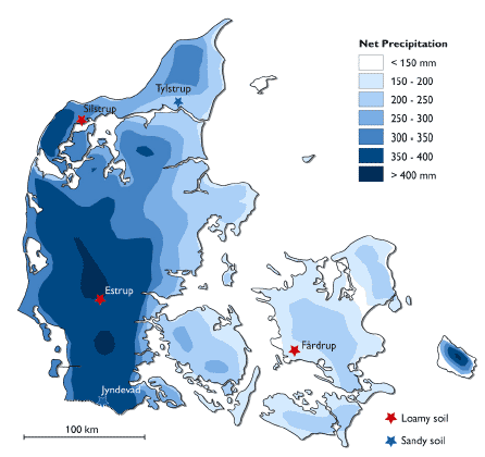
Figure 4. Location of the five PLAP sites (Tylstrup, Jyndevad, Silstrup, Estrup and Faardrup) in Denmark with map of yearly net precipitation. (The net precipitation in this figure is calculated as precipitation minus potential evaporation and therefore has lower values than shown in Figure 3).
2.4. Calibration and Validation
In the comparison of the scenarios it is important to keep in mind for each scenario their status of calibration and validation. This can be grouped with respect to the scenarios as follows:
- Karup and Langvad: Calibrated against a large scale yearly water balance. Some input parameters have been collected.
- Hamburg: An artificial scenario based on the National German Scenario. Some input parameters have been collected.
- Tylstrup, Jyndevad, Silstrup, Estrup, and Faardrup: The PLAP-model-scenarios have been: (1) setup based on an extensive amount of direct measurements of hydraulic and geological parameters; (2) calibrated using measured groundwater table, soil water content at three depths, drainage runoff at clay soils, bromide concentrations in suction cups, and bromide concentrations in drains for the period May 1999 – May 2004; and (3) validated against water balance and bromide transport for a two year period (Kjær et al., 2007). The results of the validation demonstrate, the PLAP-model-scenarios ability to predict percolation and bromide leaching,
It should be emphasised that none of these scenarios have been calibrated nor validated against direct measured pesticide transport. This is presently possible to do for the PLAP scenarios but is not a part of this study.
Version 1.0 August 2007, © Danish Environmental Protection Agency