Acceptance criteria in Denmark and the EU
3 Use of risk acceptance criteria within the EU
- 3.1 Land Use Planning Guidelines from the European Commission
- 3.2 European Commission’s examples of risk analysis methods (‘Roadmaps’)
- 3.3 Risk acceptance criteria in Finland
- 3.4 Risk acceptance criteria in Flanders
- 3.5 Risk acceptance criteria in France
- 3.6 Risk acceptance criteria in the Netherlands
- 3.7 Risk acceptance criteria in Iceland
- 3.8 Risk acceptance criteria in the United Kingdom
- 3.9 Risk acceptance criteria in Germany
This chapter describes risk analysis methods and risk acceptance criteria in relation to land use planning for, or around, major hazard establishments in the European Union. The European Commission has published two guides regarding practical implementation of the land use planning regulations in the Seveso II Directive (European Commission, 1999; European Commission, 2006). The Commission has also prepared an overview of available ‘Roadmaps’ (European Commission, 2007) containing further technical details and implementation examples from a number of EU Member States.
These guides and the publication ‘Roadmaps are described below, followed by a more detailed review of practices in seven selected countries (Finland, Flanders, France, Germany, Iceland, the Netherlands and the United Kingdom).
3.1 Land Use Planning Guidelines from the European Commission
The European Commission has prepared land use planning guidelines for major hazard establishments and surrounding areas (European Commission, 1999; European Commission, 2006). These guidelines show the various ways in which Member States can fulfil their obligations in terms of ensuring the necessary distances exist between major hazard establishments and vulnerable objects. This review focuses on the latest guidelines from 2006. These guidelines have been divided into parts A, B and C.
Part A discusses general considerations to take into account when implementing land use planning policies for major hazard establishments and surrounding areas. These concern protection of human life, natural areas, surface water and groundwater. Robust land use planning policies for major hazard establishments and/or surrounding areas should be based on:
- Consistency: to ensure that comparable determinations are reached in comparable situations.
- Proportionality: the scale of limitations (such as safety distances) should increase in proportion to the extent of the risk.
- Transparency (in the decision process).
These elements have been expressed in a number of general principles, including the need for risk analysis methods (to ensure consistency) and assessment criteria based on damage or risk (to ensure proportionality).
Part B discusses technical issues such as:
- Types of risk analysis methods.
- Risk criteria.
- Selecting accident scenarios to use in the analysis and decision process.
- Information on the frequency of critical events.
- Consequence modelling and damage impact.
A number of these issues are further discussed in sections 3.1.1 and 3.1.2 below.
Part C deals with environment issues. Most risk analysis methods (and hence risk criteria relevant to land use planning) focus on human life. The guide concludes that methods to assess risk to the environment are lacking, yet authorities are still under obligation to consider impacts to neighbouring sensitive natural areas, rare animal or plant species, and protected wetlands. Index methods are being used to a limited extent to qualify the potential for damage by dangerous substances to the environment (using a hazard index), and to qualify the sensitivity of surrounding areas (using a sensitivity index, such as sensitivity based on the speed pollution infiltrate the soil). There have been attempts to define acceptance criteria based on the time required to re-establish the original state.
3.1.1 Risk analysis methods and risk criteria
There are various approaches to risk analysis and risk criteria within the EU. The guidelines from 1999 and 2006 describe these different approaches, without recommending any single method. The most recent guideline highlights four elements on two different axes:
- 1. Quantitative (numeric) versus 2. Qualitative (non-numeric)
- 3. Deterministic (safety is defined using specific consequence analyses, without considering probability) versus 4. Probabilistic methods (safety is defined using probability distributions).
These elements exist in various combinations. Four of these combinations are further explained in the following sections.
3.1.1.1 Consequence-based risk analysis methods
Consequence-based risk analysis methods are also called deterministic risk analysis methods. Consequence-based methods are based on an assessment of the (geographic extent of) consequences of credible/conceivable accidents without explicitly quantifying their frequency. The basic principle is the ‘worst credible accident’. The philosophy is that if the necessary protection is provided to counter the worst credible accident, this protection will also be adequate in the case of smaller accidents. The probability of a given accident is only assessed implicitly in the criteria used to determine the worst credible accident or reference scenario. This assessment may be qualitative (e.g. based on the number and type of safety barriers) or quantitative. More improbable events are excluded from the analysis (see comments in section 1.3.2.2).
The consequence distance for the reference scenario is calculated using one or more exposure threshold values (e.g. one per cent deaths and hospital admissions). This method leads to delimitation of safety zones in the form of concentric circles.
3.1.1.2 Risk-based risk analysis methods
Risk-based methods perceive risk as a combination of frequency and consequence, and are examples of probabilistic methods. The consequences are analysed in the same way as in consequence-based methods, but an explicit assessment of the scenario’s frequency is included. These can be combined with various levels of sophistication. The most advanced methods are called quantitative risk analysis (see section 1.3.2.1). These methods sum the results from all the different accident scenarios, weighted in proportion to their frequency. Quantitative risk analysis generally results in two expressions of risk: location-based (individual) risk, and societal risk in the form of an F-N curve (see sections 1.2.3 and 1.2.4). Location-based (individual) risk is used to show the geographic distribution of risk, while societal risk assesses whether areas with high population density might be exposed to risk.
3.1.1.3 State-of-the-Art / Best Practice approach
This approach is not strictly a risk analysis method. The underlying philosophy is that the necessary safety measures must be in place to protect the population against the ‘worst case’ accident. This means that the establishment needs to have considered the consequences of these worst case accidents, and taken the necessary preventative and accident-limiting steps, such that the risk outside the establishment’s fence is negligible (‘zero-risk principle’). However, it is recognised that it will not always be possible to limit accidents to the establishment’s own property, and therefore safety zones are laid out, based on an assessment of typical (not necessarily the worst credible) accident scenarios.
3.1.1.4 ‘Hybrid’ methods
Risk-based methods are mentioned as an example of ‘hybrid’ methods. Under these methods, one of the elements (usually frequency) is assessed more qualitatively, i.e. using classes rather than continuous figures. Use of a risk matrix is a typical example.
Another hybrid method mentioned is the use of tables with fixed distances as a simplification of the consequence-based method. Tables of fixed safety distances are mostly used for minor or more routine situations (e.g. F-gas vehicle filling stations). The guideline points out that tables are often conservative (i.e. they employ relatively large safety distances), and are mostly used to quickly assess which situations require more analysis.
3.1.2 Other technical issues
The Commission guidelines from 2006 also discuss the data used as a basis for risk analysis. The four most important elements are:
- Selecting accident scenarios.
- Selecting accident frequencies.
- Modelling end-point values.
- ‘Technical Measures’ as defined in article 12 of the Seveso II Directive.
The Commission maintains a database to assist with the selection of accident scenarios (Risk Hazard Assessment Database – RHAD[13]). This database should contain information about relevant scenarios for each dangerous substance and activity, including frequency based on various conditions and preventative measures, but so far the database only contains few relevant scenarios.
The guidelines list five principles for scenario selection:
- Reference scenarios (equivalent to ‘reference accident scenarios’ in this report) may be selected based on frequency and the severity of the consequences.
- ‘Worst case’ accidents should not necessarily be used as a basis for land use planning, but may be assessed in connection with emergency planning and evaluation of whether the necessary measures (Best Practice) are in place to reduce the frequency of the worst case accident to a negligible level.
- Consideration should be given to the time frame over which the consequences take effect, i.e. whether there is time to activate preventative systems.
- The effectiveness of safety barriers should be included in the assessment.
- Land use planning is seen as both a preventative and mitigating measure for establishments complying with good practices under the applicable standards.
3.2 European Commission’s examples of risk analysis methods (‘Roadmaps’)
The Commission guidelines from 1999 (European Commission, 1999) contained a brief description of various example risk analysis methods for land use planning in a number of EU Member States. They also contained a brief description of practices in Australia, Canada, Russia, Switzerland and the USA.
Following the release of the guidelines in 2006, these descriptions have been expanded in a separate document, called ‘Roadmaps’ (European Commission, 2007). It is now clearly stated in the descriptions from which Member State the examples derive. There is also greater focus on the process of land use planning, with a description of the authorities and stakeholders involved and their powers.
‘Roadmaps’ also contains a detailed introduction describing the various risk analysis methods in relation to acceptance criteria and end-point values. Compared to earlier publications, there is much more focus on the use of risk matrices, with examples of a descriptive (i.e. qualitative) consequence classification.
End-point values are discussed for heat radiation, pressure from explosions, and toxicity. Distinction can be made between ‘probit functions’ and fixed values. Probit functions estimate the percentage of the exposed population that will suffer a particular injury at a particular concentration, radiation intensity, or overpressure. Threshold values specify the concentration, radiation intensity, or overpressure that results in a pre-determined damage to health. The document contains example threshold values for heat radiation and overpressure in the EU Member States, and a comparison of various toxicity data – IDLH, ERPG and AEGL[14] (data shown in Table 15 in section 4.3.6)
Land use planning methods are reviewed for the following countries: United Kingdom, France, Germany, Italy and the Netherlands. These countries, with the exception of Italy, are also discussed further in the following sections. It should be noted that the Italian method is very similar to French practices.
3.3 Risk acceptance criteria in Finland
Source:
Document written by Päivi Rantakoski and Leena Ahonen, Safety Technology Authority (TUKES) 9.8.2007.
New legislation on land use planning for major hazard establishments is being drafted in Finland. The guiding principle for planning a major hazard establishment is that an accident must not result in permanent injury or prevent people from evacuating their homes or present location. All conceivable accident scenarios must be assessed. An accident scenario may only be discounted if the operator can show that he can prevent the accident in every case. Scenarios are selected using qualitative criteria.
The TUKES safety authority is preparing guidelines for selecting appropriate end-point values for the various effects (shock waves, heat radiation, toxicity) and for selecting accident scenarios.
The consequences of the accident for people, the environment and buildings are considered. The method to be used to implement safety distances is under development. In an initial case study, three zones were placed around an establishment, depending on the magnitude of the consequences. Vulnerable objects (schools, hospitals and nursing homes) may only be placed outside the outer zone, while only other establishments may be located within the innermost zone.
The method only applies to new development, i.e. new construction in the vicinity of existing major hazard establishments, or the location of new major hazard establishments. The method is not being used to assess whether existing major hazard establishments have been located appropriately in relation to existing land use.
3.4 Risk acceptance criteria in Flanders
Source:
“Een code van goede praktijken inzake risicocriteria voor externe mensrisico’s van Seveso-inrichtingen”
Flanders uses quantitative risk criteria which are the same for both new and existing column-2 and column-3 major hazard establishments. The criteria are based on three values for location-based risk (see Table 4) and a curve for societal risk (see Figure 7). If existing establishments fail to comply with the criteria, additional safety measures will be required (such as a ‘safety information plan’, see below), their environmental permit may not be issued, or the government may prohibit operation of (parts of) the establishment.
Isolated residences (including farm buildings) are not counted as residential areas. Childcare centres and preschools are not counted as vulnerable objects.
When the iso-risk curve for 10-5 per year passes outside the establishment’s property boundary, a safety information plan has to be drawn up describing how the major hazard establishment and other establishments in the surrounding area have agreed to exchange information about risks arising from dangerous substances. Low-tier establishments are not obliged to perform a quantitative risk assessment under the Flemish implementation of the Seveso II Directive, but Flemish local authorities may require a quantitative risk assessment as a basis for an environmental approval.
Table 4. Risk criteria in Flanders.
| Location-based risk per year | Land use |
| <10-5 | Commercial activities permitted outside the establishment’s boundary line. |
| <10-6 | Residential areas (more than five residences) with no vulnerable areas (defined as schools, hospitals, nursing homes and associated land) |
| <10-7 | All types of land use permitted |
When assessing societal risk, employees and hired contractors at the major hazard establishment are not considered, but people present in neighbouring establishments are taken into account. No societal risk criteria have been set for accidents involving less than 10 fatalities. The criteria based on location-based risk must provide the necessary protection for such cases. However, establishments must show that all necessary preventative measures have been implemented for smaller accident scenarios (involving less than 10 fatalities).
3.5 Risk acceptance criteria in France
Sources:
Le plan de prevention des risques technologiques (PPRT), Guide méthodologique, Ministère de l’Écologie, du Développement et de l’Aménagement Durables.
Overview of roadmaps in selected member states (European Commission, 2007).
France has developed a detailed method for managing major hazard establishments and their surroundings. The method is risk-based, but allows for some assessment to be qualitative, and includes simplifications compared to the comprehensive quantitative risk assessments used in the Netherlands, Flanders and the United Kingdom.
The basis of the method is to identify a number of accident scenarios when assessing risk for the establishment in question. These scenarios are first divided into:
- Rapid accident scenarios.
- Slow accident scenarios. Slow scenarios are any scenarios for which the accident process permits the evacuation of all people who might be affected before the accident develops to its peak[15]. The establishment must present the necessary information to justify classification of a scenario as slow.
All scenarios are assessed with regard to their frequency. This assessment can vary from qualitative to quantitative, using the classes shown in Table 5.
Table 5. Frequency classifications for accident scenarios under the French method
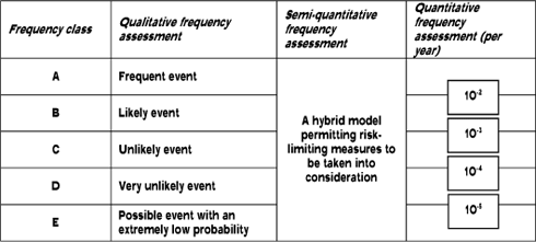
The next step is to assess the consequences. For the ‘slow scenario’, only irreversible damage to assets and the environment is assessed (as people will have been evacuated). For each scenario, the distance from the source at which the consequence will be very serious, serious, irreversible, or (where appropriate) indirect is analysed, see Table 6. In other words, a map can be drawn for each scenario showing three or four circles – one for each level of seriousness (in the case of slow scenarios, there is only one circle, for irreversible damage). These maps for the various scenarios are then summed. Toxicity, heat radiation, overpressure and the ‘slow’ scenarios are summed separately. Substances that are both flammable and toxic will result in four geographic maps showing assessments for each of these types of consequence. Some very unlikely scenarios may be excluded from the amalgamation using a ‘frequency filter’. These are only events in frequency class E fulfilling extra requirements in terms of passive safety or a minimum number of guaranteed safety barriers. Such scenarios are retained for the purposes of emergency planning.
The amalgamation takes place by summing frequency classes: Four scenarios of class E are written as ‘4E’. Scenarios are upgraded to the next class based on a factor of 10, such that 10 scenarios of class E count as one ‘D’.
The final geographic map showing consequence distances is created by:
- Determining the most serious consequence at a given location on the map.
- Summing the frequency classes which lead to the most serious consequence at this location.
- Specifying the ‘risk’ at this location using a risk matrix, such as Table 7.
Table 6. Threshold values for the French method for delimiting the consequence distance
| Consequence description |
Toxicity | Heat radiation | Overpressure (mbar) |
| Limit for very serious hazard to human life |
LC 5%1 | Greatest distance to: 8 kW/m² or 1800 [(kW/m²)4/3].s |
200 |
| Limit for serious hazard to human life |
LC 1% | Greatest distance to: 5 kW/m² or 1000 [(kW/m²)4/3].s |
140 |
| Limit for significant hazard to human life (irreversible damage) |
Limit for irreversible personal injuries |
Greatest distance to: 3 kW/m² or 600 [(kW/m²)4/3].s |
50 |
| Limit for indirect damage (broken glass) |
- | - | 20 |
Table 7. Risk matrix for location-based (individual) risk under the French method for preparing land use planning restrictions.
| Maximum consequence Frequency |
Very serious | Serious | Significant | Indirect |
| >D | TF+ | F+ | M+ | Fai |
| Between 5E and D | TF | F | M | Fai |
| <5E | F+ | M+ | Fai | Fai |
A risk management plan is prepared on the basis of these maps. These plans may contain options for compulsory purchase (only for risk zones classified as TF+ and TF) and ‘délaissement’[16] (for risk zones classified as TF+ to F). The plans take into account local conditions and historical development.
In general development of new residences or businesses (urbanisation) is forbidden in the risk zones classified as TF+ to F. Urban development is subject to special conditions in risk zones M+ to M (for toxicity or heat radiation) and M+ to Fai (for overpressure, due to the potential for glass breakage).
Institutions which are difficult to evacuate may not be built in areas where consequences are possible from ‘slow’ scenarios.
Risk management plans may also include technical measures to protect buildings and people within the hazard zone (for instance installation of explosion-proof windows). As a rule of thump, these measures may not cost more than 10 per cent of the value of the exposed assets. This applies particularly to risk zones M+ and M.
A significant element in the French method is that the local population is involved in the decision process surrounding these risk management plans.
A holistic assessment of the total risk exposure for an establishment is carried out in addition to the location-based assessment. Five seriousness classifications have been defined for accident scenarios as shown in Table 8. These are used in the risk matrix shown in Table 9. This matrix implements acceptance criteria for societal risk in France.
Table 8. Seriousness scale defined as the link between consequence and the number of people exposed.
| Consequence Seriousness |
Very serious | Serious | Significant |
| Disastrous | >10 | >100 | >1000 |
| Catastrophic | 1-10 | 10-100 | 100-1000 |
| Major | <1 | 1-10 | 10-100 |
| Serious | 0 | <1 | 1-10 |
| Moderate | 0 | 0 | <1 |
Table 9. Risk acceptance matrix for establishments in France. The red fields represent an unacceptable risk, and the plant cannot be approved. The yellow fields show where the plant can be approved, on condition that all practicable (ALARA) safety measures are implemented. The green fields show where the plant can be approved without further conditions.
| Seriousness Frequency class |
Moderate | Serious | Major | Very major | Disastrous |
| A | ALARA | No | No | No | No |
| B | OK | ALARA | No | No | No |
| C | OK | ALARA | ALARA | No | No |
| D | OK | OK | ALARA | ALARA | No |
| E | OK | OK | ALARA | ALARA | No |
3.6 Risk acceptance criteria in the Netherlands
Sources:
Decree on External Safety of Installations (Besluit externe veiligheid inrichtingen – BEVI) 2004
Guidance on the Duty of Accountability for Societal Risk
The Dutch risk criteria were implemented in a Statutory Order in 2004. They are quantitative risk criteria formulated as location-based risk, to ensure that no individual is exposed to excessive risk. Decisions by the authorities (i.e. environmental permits for establishments and urban planning close to existing establishments) must also take societal risk into consideration.
The Dutch have developed a software tool to calculate location-based (individual) risk and societal risk. This tool implements the methods from the ‘yellow’ and ‘purple’ books (Committee for the Prevention of Disasters, 1997; Committee for the Prevention of Disasters, 1999). Effective from 1 January 2008, binding guidelines require results from using this tool to form the basis of decisions by the authorities.
Distinction is made between ‘vulnerable objects’ and ‘objects with limited vulnerability’. The latter category includes scattered residences (less than two per ha), small shops and hotels, business areas, recreational objects, and objects which serve as infrastructure (electricity supply, telephone exchanges, air traffic control towers, etc.). Vulnerable objects are residences, areas for children, the aged, the sick, or the disabled (schools, preschools, nursing homes, hospitals, etc.) large (centres containing) stores and hotels (defined as more than 1500 m² of floor space) and campgrounds for over 50 people.
For vulnerable objects, a limit value for location-based risk of 10-6 per year must not be exceeded. For objects with limited vulnerability, the same value applies as a target, but may be exceeded under certain conditions. For existing environmentally approved establishments, an interim acceptance criteria of 10-5 per year applies, but the general limit value (i.e. the value used for vulnerable objects) of 10-6 per year must be complied with by 2010.
Figure 7. Combined presentation of acceptance criteria for societal risk in Denmark in accordance with Environment Project 112, including the grey ‘ALARA’ area), Flanders (section 3.4), the Netherlands (section 3.6) and the United Kingdom (indication of an unacceptable societal risk, see section 3.8).
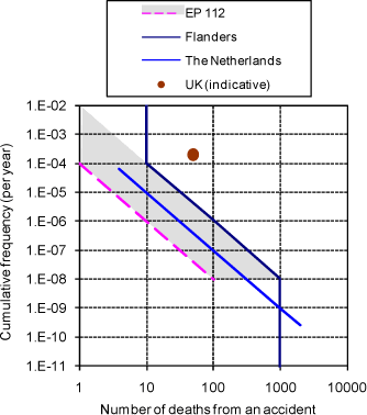
When assessing permits, the authorities must compare the calculated societal risk with the targets for risk acceptance shown in Figure 7:
- The expected frequency of accidents involving more than 10 deaths must not exceed 10-5 per year.
- For accidents involving more than 100 deaths, 10-7 per year.
- For accidents involving more than 1000 deaths, 10-9 per year.
When calculating societal risk, a maximum consequence distance is used which, by definition, covers the region where the expected mortality rate is greater than one per cent for the worst case accident.
3.7 Risk acceptance criteria in Iceland
Iceland uses fixed safety distances between major hazard establishments or stores of dangerous substances, and other buildings and types of land use. These distances are largely based on fire protection. Explicit risk considerations are not used.
Several statutory orders specify the distance from facilities storing or using dangerous substances, including the statutory order for F-gas storage and storage of flammable liquids. However these statutory orders only address relatively small amounts (25 tonnes of F-gas and 100 m³ of flammable liquid). The statutory order on explosives is the only statutory order addressing Seveso establishments. For example, this statutory order specifies a distance from ‘high-tier’ establishments (referring to an establishment with a 50,000 tonne store) as shown in Table 10.
Table 10. Safety distances from ”high-tier” establishments in Iceland
| Object | Safety distance |
| Hospitals, day-care homes, large assembly rooms and streets with dense traffic | 1100 m |
| Residential areas | 1100 m |
| Busy roads, harbours | 330 m |
| Other buildings and public roads | 330 m |
3.8 Risk acceptance criteria in the United Kingdom
Sources:
Risk criteria for land-use planning in the vicinity of major industrial hazards, UK Health and Safety Executive, ISBN 11 885491 7 (1989)
Proposals for revised policies to address societal risk around onshore non-nuclear major hazard installations, UK Health and Safety Executive, Consultative Document CD112 (2007)
The United Kingdom uses the term, ‘consultation distance’ (CD), which is comparable to safety distance in practice. These ‘consultation distances’ around each major hazard establishment are determined by the central authority, the Health and Safety Executive (HSE). The HSE performs risk calculations in each case based on information gathered via the local authorities from the establishment’s permits (Hazardous Substances Consent data, including information on quantities of dangerous substances, tank sizes, pressure and temperature, etc.). The calculations are probabilistic for toxic substances, but can be deterministic where the risk is due to the potential for fire or explosion.
Consultation distances are divided into three zones, so that the probabilities for exposure to a dangerous dose are 10-5 (inner zone), 10-6 (middle zone), and 0.3 x 10⁻⁶ (outer zone). These probabilities are approximately equivalent to individual risk or location-based risk.
Local planning authorities must consult HSE regarding any development involving a major hazard establishment or a surrounding area (i.e. within the outer consultation distance). HSE has no authority to reject a permit, but may return a ‘negative advice. However, the government guidelines state that
“in view of their acknowledged expertise in assessing the off-site risks presented by the use of
hazardous substances, any advice from HSE that planning permission should be refused for development for, at or near to a hazardous installation or pipeline should not be overridden without the most careful consideration.”
For the present, HSE only performs assessments based on individual risk (comparable to location-based risk). HSE uses 10-6 per year as the lower limit for individual risk to the general population. Any risk lower than this is not significant in relation to everyday risks. A limit of 0.3×10⁻⁶ per year is used for vulnerable people (the aged, people vulnerable to exposure). 10-5 per year is used as the upper limit for acceptable involuntary risk (involuntarily exposed people include employees in surrounding establishments, etc.).
HSE has assessed the maximum number of people permitted within the high-risk zone (up to 10-5 per year). A number of more than 25 people is considered a ‘significant risk’. Table 11 shows which types of land use are considered acceptable within the various risk zones.
Table 11. Existing basis for HSE’s assessment of new development plans
| A: residences, hotels, holiday accommodation | Negative advice when more than 25 people are exposed to individual risk exceeding 10-5 per year, or more than 75 people are exposed to individual risk exceeding 10-6 per year. |
| B: workplaces, enterprises, parking areas |
A negative advice will only be given if the risk from the major hazard establishment exceeds the normal risk for workplace accidents |
| C: Shops, meeting rooms, sport and leisure. |
No set rules, but advice will be consistent with the principles for category A. Generally cut-off figures of 100 or 300 people (at peak) are used in the two risk scenarios, respectively. |
| D: Highly vulnerable or large facilities (hospitals, schools, large category C facilities > 1000 people) |
As for category A, but the risk criteria are set lower – usually to 1/3 of the acceptance criteria for category A (0.3×10⁻⁶ per year) |
HSE has not previously assessed societal risk, partly because it used to be difficult to calculate, but an easy method has now been developed requiring fewer resources. There is a process underway in the United Kingdom to determine criteria for societal risk. There is also debate as to whether HSE’s advisory role should be extended beyond the consultation distance defined above, as societal risk is relevant outside safety distances (see sections 1.2.4 and 1.3.1). In 2001, HSE published a report entitled, ‘Reducing Risks, Protecting People’ (R2P2). This report proposes that criteria for societal risk should ensure the following condition is met: “the risk of an accident involving 50 or more deaths from a single event should be seen as unacceptable if the expected frequency is greater than once every 5000 years” (this condition has been indicated in Figure 7).
The approach described above is only used in connection with new development (construction of new residences, enterprises, etc.) in proximity to existing establishments. It is not used for approval of existing establishments.
3.9 Risk acceptance criteria in Germany
Sources:
SFK/TAA-GS-1: Störfall-Kommission technischer Ausschuss für Anlagensicherheit, Leitfaden.
Empfehlungen für Abstände zwischen Betriebsbereichen nach der Störfall-Verordnung und schutzbedürftigen Gebieten im Rahmen der
Bauleitplanung - Umsetzung § 50 BImSchG
The German ‘Störfallkommission’ prepared guidelines in 2005 for implementing article 12 of the Seveso II Directive on land use planning and ensuring the necessary distances between major hazard establishments and vulnerable objects. The guidelines draw their authority from the German Environmental Protection Act. The guidelines are not used to assess existing situations where an environmental permit has already been issued or where current general environmental regulations have been complied with.
Special distance requirements apply to stockpiles of explosives and ammonium nitrate.
Distinction is made between situations with or without detailed knowledge. Where detailed knowledge of an enterprise is unavailable (this is typical situation when planning new plant), general distance requirements are recommended based on the declared substances stored or used by the establishment. These requirements are divided into four classes, with distances of: 200, 500, 900 and 1500m (see Table 12). In Denmark these distances apply to establishments that would be covered by section 4 of the Statutory Order on Risk (“low tier” establishments), (Danish Environmental Protection Agency, 2006). These recommendations are based on consequence calculations using the following standard assumptions:
- Leakage of the dangerous substance from a 490 mm² hole (corresponding to a break in a DN 25 pipe[17]).
- Flammable substances ignite immediately.
- Atmospheric dissemination calculated as described in VDI Guideline 3783, using average meteorological conditions for industrial areas, such as a wind speed of 3 m/s.
- A threshold value of 1.6 kW/m² for heat radiation.
- A threshold value of 0.1 bar for maximum overpressure for explosions (average between 0.175 bar for hearing damage, and 0.05 bar for personal injury due to glass splinters).
- A threshold value for toxic substances equal to the EPRG[18] 2 value.
Where detailed knowledge of an industry is available (for example, in relation to land use planning around existing establishments), consequence calculations are performed for the specific establishment. These calculations are based on the above assumptions, though certain freedom is permitted in selecting scenarios (such as the size of a hole – it is recommended that a hole size greater than 80 mm² be used for the calculations). Where dangerous substances are stored in tanks or cylinders, leakage from a single unit (tank or cylinder) is assumed. Accident-limiting measures are taken into account in consequence assessment. Fire, explosion and toxic effects are assessed separately.
Table 12. German recommended distance requirements for use when detailed consequence calculations are not available
| Class 1, required distance: 200 m | Class II, required distance: 500 m | Class III, required distance: 900 m | Class IV, required distance: 1500 m |
| Ethylene oxide Acrylonitrile Hydrogen chloride Methanol Propane (F-gas) Benzene |
Oleum 65% (Sulphur trioxide) Bromine Ammonia Hydrogen fluoride Fluorine |
Sulphur dioxide Hydrogen sulphide Formaldehyde (>90%) Hydrogen cyanide, HCN |
Phosgene Acrolein Chlorine |
[13] http://mahbsrv4.jrc.it/rhadnew-v3/adminindex.html
[14] IDLH: Immediately Dangerous for Life and Health (values developed for emergency personnel); ERPG: Emergency Response Planning Guidelines (values developed for workers, i.e. people in good health); AEGL: Acute Emergency Guidance Level (values being developed for the general population)
[15]> A typical example of a slow accident scenario is ‘boil over’: when a storage tank fire is permitted to continue burning, oil at the base of the tank eventually gets so hot that it begins to boil. This is a very violent process, but there is time to evacuate the nearby population before it happens.
[16] ‘Délaissement’ refers to a French legal construction whereby the authorities can prohibit land or buildings from being re-used once they are vacated by the existing owners/users, combined with an obligation on the part of the authorities to acquire the property if the owners so wish.
[17] A DN 15 pipe is assumed for phosgene.
[18] EPRG: Emergency Response Planning Guidelines (see also note 14). Three concentrations are specified for each substance (EPRG 1 to EPRG 3). The EPRG 2 value for a substance is the airborne concentration that almost every person can be exposed to for one hour without experiencing permanent injury or effects that would prevent their escape.
Version 1.0 Marts 2009, © Danish Environmental Protection Agency