[Front page] [Contents] [Previous] [Next] |
Point and non-point source leaching of pesticides in a till groundwater catchment
4 Results of investigations
4.1 Geological and hydrogeological investigations
4.1.1 The glacial sequence
Point source site
In the point source area the excavated profile was approximately 4-5 m deep and 16 m wide, Figure 6a. Described from the top of the profile unsorted fill including cobbles, gravel, black soil and grey sand occurred. The fill layer had a thickness of 0.5 m and was underlain by freshwater lake deposits of gytja formed in a natural depression, now levelled by the fill. Below the gytja a clay rich sandy till greyish-brown (oxidized) with vertical fractures of reddish staining and a lengths of 0.3-1.5 m was exposed. Inclining from 2.5 to about 4 m depth in the excavation an 0.5-1 meter thick sand layer occurred with pronounced planar bedding and cross bedding (dislocated meltwater sand). From approximately 4 m's depth the till was olive grey and chemically reduced.
Revealed by the angled borings, chemically reduced conditions (olive grey) continued below the excavation. The till was calcareous and silty with gravel and intercalated by minor sand lenses/layers, Figure 3. A sandy body occurred at 15-17 m depth and at approximately 23 m depth a sand layer was reached. The sand layer is believed to represent the more widespread sand aquifer know from other borings to override the main limestone aquifer.
Orcard
The geological profile excavated in the orchard is displayed in Figure 6b. In the upper 1-1.3 m the profile was intensively burrowed by roots and earthworms. In the lower part of this zone, biopores and fractures (macropores) were bleached, indicating the maximum seasonal elevation of the water table (water saturation), typical of autumn and winter (Jřrgensen & Fredericia, 1992 and Jřrgensen & Spliid, 1997). The soil (upper approximately 1 m) was classified as a Typic Hapludalf, according to the American Soil Taxonomy system.
Below the top-soil, the excavation (approximately 6 m deep) exposed a yellowish brown oxidized till which appeared uniform to the redox transition at 4.5-5.5 m depth. Below this depth the till was greyish and chemically reduced. In the bottom part of the profile minor sand lenses/layers appeared, i.e. a 1-10 cm thick horizontal layer of silty sand and gravel, which may be representative of the intercalations also found deeper in the angled borings. Below the excavation the reduced till continued, as revealed by the angled borings. The till was mainly silty with gravel, and intercalated by minor sand lenses/layers, Figure 4.
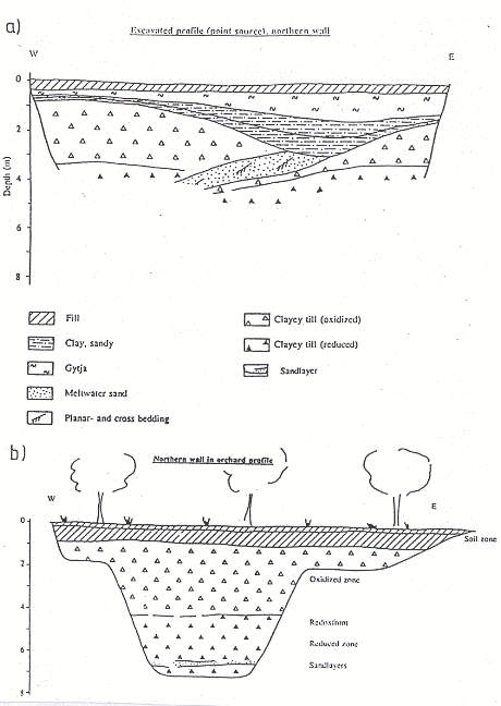
Figure 6
Geological profile of excavations, in a) the point source site and b) orchard
(monitoring section)
Geologisk profile i udgravninger i, a) punktkilden og b) plantagen (moniteringsparcel)
4.1.2 Description of fractures
Point source site
The fractures in the point source area were mapped in the depths of 2-3 m and 4.5 m below surface. A total of 24 fractures was measured. At both levels there was a weak preferred orientation of fracture strikes at 45o and 150o. Most of the fractures were near vertical (+/- 15o) except from two fractures with the orientation 51/22SE and 90/30S, Figure 7a. Some fractures surfaces occur in the meltwater sand layer (shown in Figure 7a) and can be followed from the sand layer into the underlying till. This suggests an origin of the fractures as tectonic rather than as a result of desiccation. The only good exposure with larger fractures was in the NW corner of the profile. The average fracture spacing was about 0.3 m, but rather poorly defined due to weak chemical staining of the fracture walls.

Figure 7
Fracture strikes measured in, a) the point source site and b) the orchard
(monitoringsection). N is number of measurements
Sprćkkeorienteringer (strygning) mĺlt i, a) punktkilden og b) plantagen (moniteringsparcel). N er antallet af mĺlinger
Orchard
The fractures in the orchard have been similarly measured. From the top of the profile the upper 1.5 m was heavily fractured. The fractures often seemed to be connected by boulders. Only in the upper metres of the reduced till zone the fractures were visible due to ironoxide stained fracture walls. However, at greater depths the till tends to bread along fracture planes. The orientation of the fractures shows a vague maximum at 70o and 150o, Figure 7b. The majority of the fractures were sub-vertical, but some sub-horizontal fractures were also observed. At larger depth the fracture spacing increased, and below 4 to 5 m only a few fractures were identified. However, the lack of staining of the fracture walls may obscure the identification of fractures.
Comparing the fracturing of the orchard and the point source site, the former appears to be more intensive. This is corroborating with a prevailing water saturation which is indicated (by the lake deposits on top of the profile) to occur at the point source site. As a consequence of permanent water saturation jointing by desiccation is expected to be rare and staining of fracture walls is expected to be weak. Thus, fractures of glacial origin should be expected to be the dominant fracture type at point source site.
4.1.3 Groundwater levels and hydraulic gradients
The pressure heads in the monitoring wells were measured through 1993 and 1994. The
measurements showed a pronounced seasonality, Figure 8. In the upper screens in the till
the pressure heads fluctuated from level +2.9 m to +1.7 m. Vertical hydraulic gradients of
0.1 - 0.7 were measured with a direction from the till towards to the sand aquifer. The
pressure head in the sand aquifer (measured in well 2, screen IV), decreased through the
period from level +0.3 m to 1.7 m with a gradient of approximately 0.6 directed from the
till to the sand aquifer. The average hydraulic gradient across the aquitard was 0.2.
4.1.4 Tritium profiles
Types of samples
Tritium was measured in water samples distilled from Shelby tube cores (three profiles) and in water samples collected from the screens (five profiles) of the wells. Tritium profiles corresponding to each of the sample types are shown in Figure 9.
Depths of peak and minimum values
It appears that the core data are uniform in the three wells showing tritium concentration peak values at 5-7 m depth in all wells. At depths of more than 12-17 m, the core tritium is below the limit of detection (1 TU). The data representing the screens essentially follow the same pattern. However, two deep screens (point source wells 1 and 2) had tritium values above the limit of detection, while no tritium was measured in the core samples from the same depths.
When evaluating the tritium profiles it should be noticed that the core data are point measurements, while the screens represent water which may have been transported several metres by fractures due to pumping (prior to and during the sampling). In particular, partially penetrating vertical fractures may cause artificial redistribution of tritium (and other contaminants) due to pumping, because these fractures prior to pumping had minor contribution to adjective transport (due to their dead-end termination in the till). Such transport may account for the occurrence of tritium in the two deep screens mentioned above. Alternatively, tritium may have been transported inside the wells. However, this appears to be less likely, since, the screens above the screens with enhanced tritium, had no tritium.
Hydraulic active zone
The repeated occurrence of high tritium values in the top of the profiles suggests the occurrence of a "hydraulically active layer" of approximately 5-10 m thickness. Fractures may extent from this layer into the lower till. However, evaluated from the core samples, highly conductive fractures are not expected to penetrate the entire till sequence. Further interpretation of flow mechanisms in the till aquitard is carried out by numerical analyses presented in the modelling section (section 5.3).
4.1.5 Hydraulic laboratory experiments
Hydraulic conductivity and soil pressure
Applying the large undisturbed columns, collected from 2-6 m's depth in the orchard and the point source site, two series of hydraulic experiments were carried out. In one serie, bulk hydraulic conductivities were determined at the in-situ soil pressures representing of the individual column sampling depths. In a following serie of experiments bulk hydraulic conductivities of the columns were measured at experimentally increased confining pressures representing depositional overload at different depths in the till.

Figure 8
Hydraulic heads measured in monitoring wells 1 and 2 (point source) and 5 (orchard
monitoring section)
Hydraulisk trykhřjder i moniteringsboringerne 1 og 2 (punktkilde) og 5 (plantagen)

Figure 9
Tritium profiles of the angled monitoring wells in the point source site and orchard
Tritiumprofiler for skrĺ monitoringsboringer i punktkilden og plantagen
The results of the in-situ pressure experiments are summarized in Table 3. Additionally, in the table are shown hydraulic conductivities of the unfractured till matrix determined with small samples collected from selected large undisturbed columns.
Hydraulic apertures and conductivity of fractures
Base case hydraulic conductivities (Kf) of fractures and the fracture apertures (2b) were calculated using the approach of Snow (1969), where:
| 1 | (4.1) |
and
| 2 | (4.2) |
Km = hydraulic conductivity of matrix,
s = fluid density,
g = acceleration of gravity,
m = dynamic viscosity of water and
2B = fracture spacing
Fracture porosity
Fracture porosity (nf) is given by
| 3 | (4.3) |
The calculated values are shown in Table 3. Fracture porosities of the columns are 0.0001-0.0008 which is equivalent to 10-80 ml. Column volumes of total porosity are 25-32 l. Based on the fracture values calculated mean flow velocities in the fractures are 2-34 m/day at a hydraulic gradient of 1.
Table 3
Observed fracture spacings and calculated physical data in undisturbed columns
Observerede sprćkkeafstande og beregnede fysiske data for uforstyrrede sřjler
Spacing (2B) |
Fracture aperture (2b) |
Fracture porosity (nf) |
Fracture hydraulic conductivity |
Bulk hydraulic conduction |
|
| Column 1, orchard | 0.05-0.07 |
20-22 |
0.0008 |
2.5 x 10⁻⁴ |
2.0 x 10⁻⁷ |
| Column 2, orchard | 0.05-0.10 |
7-8 |
0.0003 |
3.1 x 10⁻⁵ |
7.2 x 10⁻⁹ |
| Column 3, orchard | 0.05-0.10 |
6-8 |
0.0002 |
2.2 x 10⁻⁵ |
6.0 x 10⁻⁹ |
| Column 1, point source | 0.20-0.25 |
12-13 |
0.0001 |
9.0 x 10⁻⁵ |
1.2 x 10⁻⁸ |
| Matrix from Column 1, point source |
- |
- |
0 |
0 |
2.0 x 10⁻⁹ |
| Column 2, point source | 0.25-0.30 |
16-17 |
0.0001 |
1.6 x 10⁻⁴ |
2.0 x 10⁻⁸ |
| Matrix from Column 2, point source |
- |
- |
0 |
0 |
1.0 x 10⁻⁹ |
| Column 3, point source | 0.25-0.30 |
13-14 |
0.0001 |
1.0 x 10⁻⁴ |
1.2 x 10⁻⁸ |
| Column 4, point source | 0.15-0.20 |
25.27 |
0.0003 |
3.9 x 10⁻⁴ |
1.2 x 10⁻⁷ |
The experiments reveal significant difference in hydraulic conductivity and control of fractures on flow in the columns. The hydraulic conductivity of the columns was decreasing with column sampling depth. This is consistent with the field observation of the fracture density decreasing with depth.
Flow in fractures
In the shallow Column 1, orchard flow was controlled by fractures, and the hydraulic conductivities observed were comparable with values of fractured oxidized clayey till observed at other sites in Denmark (Jřrgensen 1995). In this column bulk hydraulic conductivities were 2-3 orders of magnitude higher than the conductivity of the matrix.
In the deeper columns the hydraulic conductivities were approximately 1 order of magnitude higher (Columns 2 and 4, point source) or close to the hydraulic conductivity of the matrix (Columns 2 and 3, orchard). This is indicating a significant contribution to transport by matrix flow with depth.
4.1.6 Stability of fractures at depositional overburden
The effect of soil depth on fracture hydraulic conductivity (stability of fracture apertures) was investigated by determining hydraulic conductivities at various permeameter cell pressure simulating increasing depositional overburden.
Confining pressures
The experiments were initiated at in-situ soil pressures of the columns. From these pressures a confining maximum cell pressure of 240 kPa (corresponding to 20-25 m depth) was established through the steps 90, 120, 160, 240 kPa. The hydraulic conductivities were measured at steady state flow at each pressure level after consolidation of the columns had ceased. The results is shown in Figure 10 and Table 4.
Table 4
Hydraulic conductivities measured at in-situ soil pressures and at increased pressures
Hydrauliske ledningsevner mĺlt ved trykstigningsforsřg
Kb m/sec |
||||
in-situ |
120 kPa |
160 kPa |
240 kPa |
|
| Column 1, orchard | 1.2 x 10⁻⁶ |
1.2 x 10⁻⁶ |
1.1 x 10⁻⁶ |
1.1 x 10⁻⁶ |
| Column 3, orchard | 1.6 x 10⁻⁸ |
- |
1.6 x 10⁻⁸ |
1.7 x 10⁻⁸ |
| Column 2, point source | 2.5 x 10⁻⁹ |
- |
3.1 x 10⁻⁹ |
3.2 x 10⁻⁹ |
| Column 3, point source | 1.1 x 10⁻⁸ |
9.6 x 10⁻⁹ |
8.9 x 10⁻⁹ |
6.8 x 10⁻⁹ |
| Column 4, point source | 1.0 x 10⁻⁷ |
9.2 x 10⁻⁸ |
8.4 x 10⁻⁸ |
7.1 x 10⁻⁸ |
Influence of soil pressure
The data displayed reveals, that only minor changes in bulk hydraulic conductivities occurred even at the maximum cell pressure of 240 kPa. It may be predicted from the cubic law (eq. 4.2) that flow (L3/T) of a fracture is a cubic function of the fracture aperture (L). Consequently, even small changes in fracture aperture should result in significant reduction of fracture hydraulic conductivity, and in cases where fractures control flow, also the bulk hydraulic conductivity should be reduced significantly.
The minor variations in bulk hydraulic conductivity suggests that fracture apertures may only be weakly influenced by depositional overload, and consequently, may be conductive at greater depths than at the upper 2-6 m represented by the columns. However, the difference in duration for consolidation at the lab scale versus the field scale is orders of magnitude when measured in years. It should therefore be noticed that possible long term effects of consolidation have not been analyzed by the experiments.
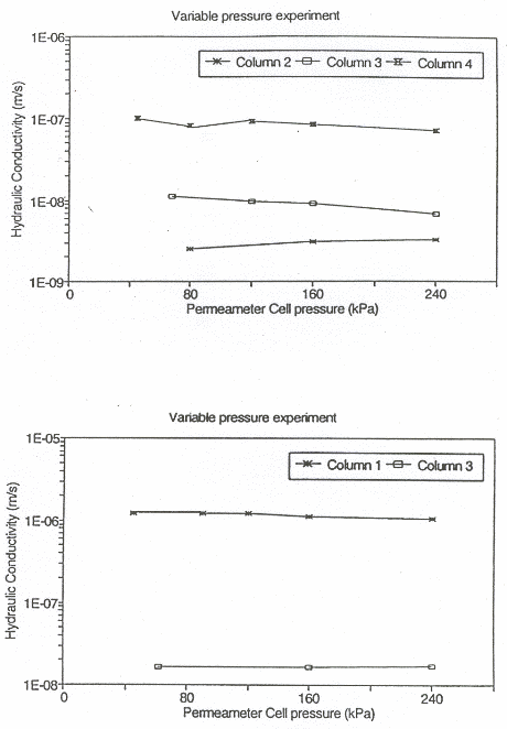
Figure 10
Hydraulic conductivities versus applied confining cell pressure of large undisturbed
columns measured during soil pressure experiments
Hydrauliske ledningsevner mĺlt under trykstigningsforsřg med intakte sřjler
4.2 Pesticides in soil and groundwater
4.2.1 Degradation of pesticides
Oxic degradation
Pesticide degradation has major influence on breakthrough concentrations of leaching in fractured clay till and on the recovery after contaminant source has ceased. The effects are analyzed by Jřrgensen and Spliid (1979). For assessment of risks, however, there is minimal information available about pesticide degradation rates in the deeper (>1 m depth) geological environments. One of the few published studies (Agertved and Rügge, 1992) showed degradation of mecoprop in an oxic sand aquifer while no degradation was measured for atrazine (similar to simazine with respect to persistence).
Anoxic degradation
Another investigation of a contaminant plume rich in organics from Vejen Landfill (Heron and Futtrup, 1991) showed little or no degradation in the central anoxic part of the contaminant plume, while apparently rapid degradation of mecoprop occurred in the oxic margin of the advancing plume. This suggests a higher persistence of phenoxyherbicides at anoxic conditions than under oxic conditions. Mecoprop may transform via biodegradation into the potentially mobile degradation products MCPA and 4-chloro-2-methylphenol (Agertved & Rügge, 1992). Another portion of the pesticide is built into stable organic soil compounds, and eventually some of the pesticide can be strongly adsorbed (Helweg, 1993 and next section, this report).
4.2.2 Pesticide adsorption on clay minerals
In the soil layers of the root zone the mineral surfaces are to a certain extent covered by adsorbed organic matter and not fully available for adsorption of pesticides. In deeper layers of clay soils the negatively charged clay surfaces are exposed and adsorption may be very significant for cationic pesticides (Weber, 1966; Bailey et al., 1968; Weed and Weber,
Mechanisms
1968) Neutral pesticides may be adsorbed through van der Waal's forces (Mengelgrin and Tsvetkov, 1985; Rodriguez et al., 1988). Anionic pesticides are normally repelled by the clay mineral surface (Bailey et al., 1978, Mortland, 1970), but may be adsorbed through bonding to adsorbed inorganic cations.
Samples analyzed and mineralogy
Powder diffractometry carried out with total till matrix samples which were ground to pass a 0.25 mm sieve, showed the presence of quartz, feldspars, calcite and clay minerals. The amounts of quartz and feldspares increase with decreasing amounts of clay <2 mm in the samples. The presence of large amounts of calcite in all samples demonstrates the low degree of weathering of the till.
The clay mineralogy was analyzed in the all core samples collected from the point source excavation and from well 4 m in the orchard.
The clay fraction at 1.3 m depth in the point source was dominated by vermiculite and further contained some smectite, illite, kaolinite, and chlorite, whereas the other samples contained vermiculite, illite, and smectite in fair amounts together with small amounts of chlorite and kaolinite.
The sample form the orchard at 2.1 m depth was different by not containing chlorite in detectable amounts. The similar clay mineralogy of coarse- and fine-grained samples fits well with the low degree of weathering as deducted from the presence of calcite.
Sorption experiments
Pesticide adsorption was investigated with core sample material sampled in well 4 at the depths of 2.1 and 22 m. The amounts of simazine adsorbed at natural pH by the samples were 1.8 and 5.6 mg/10 g sample, at 2.1 m and 22 m depth, respectively. This corresponds roughly to 0.2 and 0.5 g/m3 of sediment, respectively.
Sorption capacities
For these two samples, with approximately the same clay mineralogy, the difference in simazine adsorption capacity correlates well with the amounts of clay <2 mm. It may tentatively be concluded, that for the simazine the clay fraction is the active adsorber. Assuming this, one can calculate the simazine adsorption capacity of the clay fraction to 5 mm simazine per gram clay fraction at pH 7.8. Further experiments are needed to elucidate the role of the different clay minerals in the adsorption process. It is surprising that simazine is adsorbed in these rather large amounts at a pH of 7.5 where simazine is predominantly a neutral molecule, since the largest adsorption capacity from experiments with standard smectite (Weber, 1996) was found at low pH values where trazines are protonated. The calcium present on the exchange sites of the clay minerals in the present samples may, however, play a role in the adsorption process.
4.2.3 History of pesticide application
Objectives of pesticide mapping
The pesticides applied in the project area were mapped to evaluate cause-effect relationship of pesticide application and groundwater quality. For a comparison of the potential sources of pesticides contamination in the project area the mapping was carried out in the following units of land use:
• orchard section with monitoring wells
• orchard
• agricultural area.
Pesticides in orchard and sources of information
Distribution of the three units is shown in Figure 1.
The earliest records of pesticide use in the orchards is from 1919. However, the pesticide mapping was limited to cover 2nd and 3rd generation pesticides from approximately 1956, as these were considered to be the most important hazards to groundwater quality. The following list of compounds to be mapped was selected from the quality control guidance for water supply wells: DNOC, atrazine, simazine, 2,4-D, MCPA, mecoprop and dichlorprop. The list was extended with amitrol and terbuthylazin, as these were relevant in parts of the orchard.
For the period 1956-1984 the pesticide use was estimated. Mapping was based on the general information of agricultural statistics, consultants' recommendations and interviews of the former managers of Skćlskřr orchards etc.
Table 5 gives information of pesticide use in the orchard.
Table 5
Use of pesticides in the orchard in the period 1962 - 1992
Pesticider anvendt i Skćlskřr frugtplantage i perioden 1962 - 1992
Product/period |
Dose |
Active |
Dose |
Load on the area |
Average loak |
| Simazine, 1962-71 | 2-3 |
simazine 50% |
1,25 |
40% |
0,50 |
| Simazine, 1972-83 | 2-3 |
simazine 50% |
1,25 |
24% |
0,30 |
| Weedazol, 1965-73 | 5 |
amitrol 21,3% |
1,07 |
40% |
0,43 |
| Amitrol, 1974-1983 | 1 |
amitrol 95% |
0,95 |
20% |
0,19 |
| Pramitol-M 80, 1972-83 | 2-3 |
terbuthylazon 80% |
2,00 |
16% |
0,32 |
| Herbatox-M 750, 1974-83 | 1,3 |
MCPA 75% |
0,98 |
20% |
0,20 |
| Herbatox-DPD 450, 1981-83 | 3-5 |
2,4D 300 g/l dichlorprop 300 g/l |
1,20 1,20 |
20% |
0,24 0,24 |
| Herbatox-Combi 3, 1981-83 | 3-5 |
2,4 D 120 g/l dichlorprop 420 g/l MCPA 100 g/l |
0,48 1,68 0,40 |
20% |
0,10 0,34 0,08 |
The mapping of pesticides used in the orchard in 1984-92 was based on high quality records subdividing the orchard into 20 sections of individual treatment given by the conditions and cultures. Details of criteria for mapping and evaluation of quality of available information are given in CNS-report, Enclosure 1.
History of pesticide application
MCPA was the first phenoxyherbicide to be used regularly in Skćlskřr orchard, Figure 11. It was introduced in the early 1970'ies while dichlorprop, 2,4-D and mecoprop were introduced ten years later in the early 1980'ies. Focusing specifically on the monitoring section of the orchard (Figure 12) the phenoxyherbicide dichlorprop was used in 2 time higher amounts that in the rest of the orchard, Figure 11.
The amounts used of 2,4-D and MCPA were approximately 1.5 times higher than the average value for the orchard. Metoprop is the only phenoxyherbicide which has been used in less amounts in the monitoring section than the average for the total orchard.

Figure 11
Use of selected pesticides in Skćlskřr orchard (1965-1992)
Udvalgte pesticiders anvendelse i Skćlskřr frugtplantage (1965-1992)
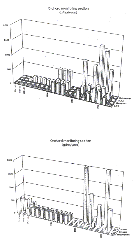
Figure 12
Use of selected pesticides in monitoring section (Skćlskřr orchard) in period 1965-1992
Udvalgte pesticiders anvendelse i monitoringsparcel (Skćlskřr frugtplantage) i perioden 1965-1992
The herbicides amitrol and simazine have been used in the orchard since the early 1960's and terbuthylazine since early 1970'ies, Figure 11. In the monitoring section amitrol has been used in high amounts, while simazine and terbuthylazine have been used less than in the remaining part of the orchard. According to the mapping none of these latter herbicides have been used in crops on arable land, Figure 13.
Summary information of pesticide use in the three mapping units is shown in Table 6. Comparing the phenoxyherbicide use in the orchard with the agricultural area in the table, the following differences in the pattern of use are to be noticed:
History of use on farm land
In the agricultural area the phenoxyherbicides were introduced in 1960-1970 while in the orchard they were introduced in 1970-1980. In the orchard the phenoxyherbicides have only been used in the summer (May/June). Since 1980 in agricultural areas application of MCPP in the autumn has become common. Application in autumn implicates increased risk of leaching from the root-zone of newly applied pesticides due to maintained surplus of precipitation and water saturation of the soils (Jřrgensen and Spliid, 1997).
Table 6
Summary information of pesticide used in the three mapping units
Sammenfattende oplysninger om pesticidanvendelser i de tre kortlćgningsenheder
| Active ingredient | Period of use (total amount in kg/ha) |
|||
Monitoring section |
Average in orchard |
Agricultural areas |
||
| Dichlorprop | 1981-1991 |
1981-1991 |
1996-1994 |
|
| Mecoprop (MCPP) |
1961-1991 |
1984-1989 |
1961-1994 |
|
| 2,4 D | 1981-1991 |
1981-1991 |
1961-1994 |
|
| MCPA | 1971-1991 |
1971-1991 |
1956-1994 |
|
| Total of phenoxy herbicides | 14.0 |
11.2 |
14.4 |
|
| Amitrol | 1961-1990 (9.62) |
1961-1990 (5.50) |
- (0) |
|
| Simazine | 1961-1991 (5.50) |
1961-1991 (5.98) |
- (0) |
|
| Terbuthylazine | 1971-1983 (2.83) |
1971-1990 (5.44) |
- (0) |
|
| Total of amitrol, Simazin and terbuthylazin |
17.95 |
16.9 |
0 |
|
| Total | 31.95 |
28.11 |
14.4 |
|
| While the amounts of pesticides shown for the orchard in Table 6 are based on specific records, the amounts shown for the agricultural areas are average figures, representing the total sale of phenoxyherbicides in Denmark distributed evenly on the total area of Danish wheat lands. The resulting figures are considerably lower than the actual amounts used in areas where phenoxyherbicides have been the actual active compound. This is because other pesticides than phenoxyherbicides have been used in many areas. | ||||
| In areas where phenoxyhericides were used specifically before 1980, the applied amount in spring and winter was 2000 g/ha and 2400 g/ha, respectively. After 1985 the use on arable land has been reduced to approximately half the amount. However, since 1980 application in autumn and winter has become common. | ||||
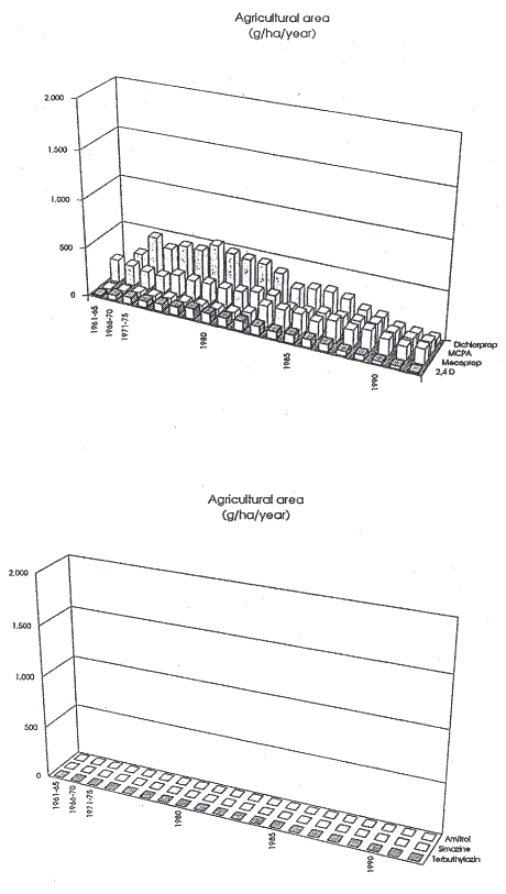
Figure 13
Use of selected pesticides in the agricultural area (1965-1992)
Udvalgte pesticiders anvendelse i landbrugsomrĺdet (1965-1992)
4.2.4 Pesticide monitoring at the point source site
Pesticides adjacent to fractures
In the point source excavation, soil samples were collected to cover the distribution of pesticides adjacent to pronounced fractures. The samples were analyzed for the pesticides simazine, MCPA, 2,4-D, mecoprop, dichlorprop and atrazine. The results are shown in Table 7 and the locations of sampling in Figure 3.
At S1 and S2 four soil samples (S), representing increasing distance to the fractures, were analyzed separately. Simazine, mecoprop and dichlorprop were detected in the samples, but no concentration gradients were shown to exist between fractures and matrix. Based on this result the samples from the remaining profiles were mixed to represent average concentrations within a distances of 0.3 m from fractures. In S1, S2 and S4 the total content of pesticides exceeded 200 mg/kg.
Table 7
Pesticides in soil samples from the excavation at the point source site (mg/kg). For location see figure 3
Pesticider i jordprřver fra udgravning i punktkilden (mg/kg). Prřvetagningspunkter er vist i Figur 3
Sample no |
Lateral distance from fracture |
Depth m |
Simazine |
MCPA |
Mecoprop |
Dichlorprop |
S6 |
0-0.3 |
2.5 |
48 |
6.3 |
9 |
n.d. |
S8 |
0-0.3 |
2.7 |
1.8 |
6.8 |
3 |
n.d. |
S7 |
0-0.3 |
2.9 |
0.5 |
3.9 |
7 |
n.d. |
S4 |
0-0.3 |
3.0 |
140 |
6.9 |
61 |
n.d. |
S1.0 |
0.0 |
4.0 |
25 |
n.d. |
76 |
85 |
S2.0 |
0.0 |
4.0 |
66 |
n.d. |
91 |
106 |
S5 |
0.0.3 |
4.0 |
65 |
11.7 |
-60 |
n.d. |
n.d.: below detection limit.
Pesticide analyses of undisturbed Shelby tube core samples from below the excavation (well 2 and well 3) are shown in Table 8. The highest content of pesticides were found in the uppermost samples of well 3 at 5.4 m depth (with a total of 273 mg/kg) and in the soil samples just below in well 2 (with a total 12.9 mg/kg).
Table 8
Pesticides in core samples from the wells 2 and 3 at the point source site (concentration in mg/kg)
Pesticider i kerneprřver fra moniteringsboringerne 2 og 3 i punktkilden (koncentrationer i mg/kg)
Well no |
Depth |
Simazine |
MCPA |
Mecoprop |
Dichlorprop |
2 |
8.0 |
1.3 |
9.0 |
n.d. |
n.d. |
2 |
11.0 |
0.4 |
n.d. |
n.d. |
n.d. |
2 |
11.0a |
n.d. |
8.2 |
n.d. |
n.d. |
2 |
12.9 |
n.d. |
12.9 |
n.d. |
n.d. |
2 |
16.4 |
6.4 |
n.f. |
n.d. |
n.d. |
2 |
18.8 |
n.d. |
2.4 |
n.d. |
n.d. |
2 |
20.6 |
n.d. |
n.d. |
n.d. |
n.d. |
3 |
2.1 |
36 |
7.2 |
n.d. |
n.d. |
3 |
5.4 |
4.0 |
n.d. |
16 |
253 |
3 |
7.4 |
n.d. |
n.d. |
n.d. |
n.d. |
3 |
7.4 |
n.d. |
n.d. |
n.d. |
n.d. |
3 |
19.7 |
n.d. |
n.d. |
n.d. |
n.d. |
3 |
12.9 |
n.d. |
n.d. |
n.d. |
n.d. |
3 |
14-7 |
n.d. |
n.d. |
n.d. |
n.d. |
n.d.: not detected
Pesticides in monitoring wells
Figure 14a show pesticide concentrations in water samples collected from 8 screens, six times over a period on approximately one year in monitoring wells 1, 3 and 4 below the point source excavation. Very high concentration of dichlorprop and mecoprop (sum concentrations up to 1 mg/l) and high concentrations of simazine in the upper screen (5-6.7 m depth) of well 3 which is consistent with the high concentrations of the same pesticides in the core sample from the same depth. In the upper filters especially the phenoxyherbicides have been identified in high concentrations in the time series, while the identification in the lower filters appears to be erratic.
Figure 14 Look here
Pesticide concentrations in water samples collected from the monitoring wells, a)
Machinery yard (point source) and b) Skćlskřr orchard
Pesticidkoncentrationer i vandprřver udtaget fra moniteringsboringer
a) plantagens maskinplads (punktkilde) og b) Skćlskřr plantage
"Hot spot" zone spill
It may be noticed that the pesticides identified in the "hot spot" area at the point source site to some extent reflect the types and relative amounts of pesticides used in the orchard as shown by the mapping based on spray records and statistical sources (section 4.2.3). In general 2.4 D and MCPA are identified in relatively less amounts than expected from the mapping, while the opposite relations appear to exist for MCPP.
Evaluating the vertical pesticide leaching, the monitoring reveals that only shallow penetration of the very high pesticide concentrations observed at the point source site has occurred. Evaluated together with the depth of the tritium leaching, the vertical transport below the upper 10 m's appears to be limited, and there are no indications of rapid vertical transport in fractures.
Regional groundwater
The Skćlskřr town main aquifer water extraction wells were analyzed to represent the end of groundwater streamlines in the project area i.e. monitoring the integrated groundwater recharge from the orchard, point sources and farm land. No pesticides were detected in the water from the wells.
4.2.5 Pesticide monitoring in the orchard
Sample materials
In the orchard (monitoring section) undisturbed Shelby tybe core samples and time series of water samples were analyzed for the pesticides simazine, atrazin, terbuthylazone, MCPA, 2,4-D, mecoprop, dichlorprop.
Pesticides in the core samples collected from well 4 are shown in Table 9.
Table 9
Pesticides in core samples from well 4 in the orchard (concentrations in mg/kg)
Pesticider i kerneprřver fra moniteringsboring 4 i Skćlskřr frugtplantage (koncentrationer i mg/kg)
Well no |
Depth |
Simazine |
MCPA |
Mecoprop |
Dichlorprop |
4 |
1.5 |
0.04 |
n.d. |
n.d. |
n.d. |
4 |
3.6 |
n.d. |
n.d. |
n.d. |
n.d. |
4 |
7.8 |
n.d. |
n.d. |
n.d. |
n.d. |
4 |
9.6 |
n.d. |
n.d. |
n.d. |
n.d. |
4 |
11.5 |
n.d. |
n.d. |
n.d. |
n.d. |
4 |
13.4 |
n.d. |
n.d. |
n.d. |
n.d. |
4 |
13.4 a |
n.d. |
7.9 |
n.d. |
9.4 |
4 |
15.7 |
n.d. |
n.d. |
n.d. |
n.d. |
4 |
19.5 |
n.d. |
n.d. |
n.d. |
n.d. |
n.d.: not detected
Monitoring wells
Low concentration of simazine have been identified in the uppermost core sample at 1.5 m depth. Additionally, MCPA and dichlorprop have been identified in a thin sandlayer at 13.4 m depth while no pesticides were identified in a sample collected a few centimetres from the sand layer.
Monitoring wells
Water samples were collected from the 7 screens six times over a period of approximately one year from monitoring wells 4 and 5. The results of the time series is shown in Figure 14b.
Low concentrations of simazine and MCPA were identified repeatedly in water samples from the till. The two pesticides have been applied intensively in the orchard and monitoring section for 20-30 years (Figure 11 and 12). However, concentrations in the water samples were erraticly distributed in time and space i.e. with no vertical trend. Dichlorprop was not identified in any of the samples. This pesticide has been applied intensively in the orchard for at least 10 years (Figure 11 and 12).
Pesticide in monitoring wells
The pattern of the pesticide finding has a low correlation with the tritium data (shown in Figure 9). While tritium shows pronounced trends of concentration versus depth and no detectable values below approximately 15 m's depth (depth of hydraulic active "zone" of the till), pesticide distribution is erratic in time and space. Single identifications of MCPA and simazine occurred at depths of less than 1 TU. The erratic pattern of pesticide findings observed may be a result of redistribution of pore water in dead end fractures during pumping (water sampling).
4.2.6 Residual pesticides in large undisturbed columns
Leaching experiments
Leaching experiments were carried out to investigate the amounts and the mobility of residual pesticides in the upper 5 - 6 m of the till in the orchard (monitoring section) and the point source site. The experiments were carried out by flushing the large undisturbed columns collected from the two sites with uncontaminated groundwater. Experimental conditions of leaching are given in section 3.3, and the results are shown in Figures 15.


Figure 15
Leaching of residual pesticides from undisturbed till columns (diam.=0.5 m) collected in machinery yard (point source spill) and Skćlskřr orchard (monitoring section)
Udvaskning af residuale pesticider fra uforstyrrede morćnesřjler
(diam.=0,5 m) udtaget fra maskinplads (punktkilde forurening) og Skćlskřr plantage
Point source site
The point source columns had very high residual concentrations of mobile dichlorprop and MCPP (sum concentrations up to 2 mg/l). Relatively lower concentrations of simazine and erratic concentrations of MCPA (sum < 10 mg/l) were identified while no 2.4-D was identified. The concentrations of dichlorprop and MCPP leached from the point source columns decreased 2-3 orders of magnitude from the shallow column (3.3 - 3.8 m's depth) to the deep column (5.2 m depth) and MCPA disappeared with depth.
Orchard site
In the columns from the orchard the observed levels of mobile pesticides were in general much lower than at the point source site. MCPA and 2.4 D were not identified in spite that these phenoxyherbicides have been applied in the monitoring section for 10 - 20 years (Figure 12 and Table 5). Dichlorprop was not identified (consistent with the field monitoring results) in spite of the extensive use in the orchard. This suggests that degradation of this pesticide occurres in the root zone. However, from the deepest column sampled in the reduced till mecoprop was identified at concentrations between 1- 10 mg/l. This is in spite that mecoprop, according to the spray records, has only been used to a minor extent in the monitoring section. The occurrence may be a result of mecoprop application in the period after 1992 or before 1984 where no spraying records are available. Simazine and terbuthylazine were identified in low concentrations in some of the effluent samples from all three orchard columns. Concentrations were less than 1 mg/l and occurred erraticly in time as also observed in the field monitoring.
[Front page] [Contents] [Previous] [Next] [Top] |