Calibration of Models Describing Pesticide Fate and Transport in Lillebæk and Odder Bæk Catchment
Appendix A
1 Water Balances and Issues to Precipitation Data in the Odder Bæk-Catchment
In Table 1, the annual water balance figures are shown for Lillebæk catchment. Precipitation is calculated based on the Bolsmose station with the new standard monthly corrections (Allerup et al., 1998).
Table 1 Water balance, Lillebæk
| Year | Bolsmose | Årslev | |
| precipitation, mm | Potential evaporation, mm | measured runoff, Fredsskovsvej, 1000m3 |
|
| 1989 | 681 | 573 | 567 |
| 1990 | 961 | 613 | 887 |
| 1991 | 818 | 573 | 1015 |
| 1992 | 811 | 634 | 812 |
| 1993 | 964 | 549 | 1292 |
| 1994 | 1159 | 610 | 1941 |
| 1995 | 712 | 629 | 1362 |
| 1996 | 631 | 572 | 237 |
| 1997 | 720 | 639 | 338 |
| 1998 | 1036 | 538 | 1255 |
| 1999 | 1091 | 613 | 1867 |
| 2000 | 884 | 553 | 1094 |
For Odder Bæk, the choice of climatic data went through several iterations. Until the end of 1994, precipitation was measured at station 20555 just outside the catchment. For the rest of the period of interest (1994-2000), the suggested data consists of different averages constructed from nearby stations. However, data analysis and simulations showed considerable systematic differences between the original station and the different averages. The local station measured consistently less rain than the stations surrounding it. At the same time, correlations between the local rainfall station and measured runoff is excellent (Figure 2), indicating that the local station is the most reliable record.
With assistance from Danish Meteorological Institute (DMI), a correlation was established between the grid precipitation calculated by DMI for the grid in which the catchment is situated (10215), and station 20555 (P = 0.926 * Pgrid, R2 = 0.96). However, it should be noted that the station 20555 is part of the dataset used for calculation of the grid precipitation until the end of 1994. There could therefore be a trend in the data, due to this.
Other stations nearby were poorly correlated with the local station.
The precipitation record finally selected is grid precipitation from DMI for grid no. 10215, modified with the above correlation. The correction factors used stem from Vejen et al. (2000) and (2001). Evaporation is calculated according to Makkink, for the same grid.
Table 2 Odder Bæk. Precipitation calculated with the new dynamic corrections.
| Year | Grid data * 0.926 | Local station 20555 |
Grid data | |
| precipitation, mm | Potential evaporation, mm | measured runoff, 1000m3 | ||
| 1989 | 621.6 | 655.7 | 573 | 2262 |
| 1990 | 795.5 | 797.1 | 613 | 2675 |
| 1991 | 649.1 | 630.0 | 573 | 2379 |
| 1992 | 706.6 | 674.5 | 634 | 1982 |
| 1993 | 789.0 | 758.0 | 549 | 2029 |
| 1994 | 886.6 | 775.8 | 610 | 3312 |
| 1995 | 716.1 | 629 | 2806 | |
| 1996 | 597.2 | 572 | 1439 | |
| 1997 | 711.2 | 639 | 1690 | |
| 1998 | 920.8 | 538 | 2354 | |
| 1999 | 985.0 | 613 | 3172 | |
| 2000 | 945.6 | 553 | 3290 |
For Odder Bæk, the choice of climatic data went through several iterations. Until the end of 1994, precipitation was measured at station 20555 just outside the catchment. The location of the precipitation stations in comparison with the catchment is shown in Figure 1. For the rest of the period of interest (1994-2000), the precipitation data suggested by NERI consists of different averages constructed from nearby stations. However, data analysis and simulations showed considerable systematic differences between the original station and the different averages. The local station measured consistently less rain than the stations surrounding it. At the same time, correlations between the local rainfall station and measured runoff is excellent (Figure 2), indicating that the local station is the most reliable record.
With assistance from Danish Meteorological Institute (DMI), a correlation was established between the grid precipitation calculated by DMI for the grid in which the catchment is situated (10215), and the local station (20555). The relation is
P = 0.926 * Pgrid, R2 = 0.96
However, it should be noted that the station 20555 is part of the dataset used for calculation of the grid precipitation until the end of 1994. There could therefore be a trend in the data, due to this.
Other stations nearby were poorly correlated with the local station. Figure 1 also shows the location of station 20540, which is situated north of the catchment. Figure 3, Figure 4 and Figure 5 show the correlations between 20540 and grid-precipitation, 22555 and grid-precipitation, and the correlation between the two stations. Obviously the station 20540 contains more water and the correlation to 20555 is poorer than for the grid precipitation.
Figure 6 and Figure 7 show the difference on the datasets on daily values.
The precipitation record finally selected is grid precipitation from DMI for grid no. 10215, modified with the above correlation. The correction factors used stem from Vejen et al. (2000) and (2001). Evaporation is calculated according to Makkink, for the same grid.
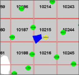
Figure 1 Location of Odder Bæk catchment in comparison to precipitation stations and the 10 km2-grids available with Danish Meteorological Institute.
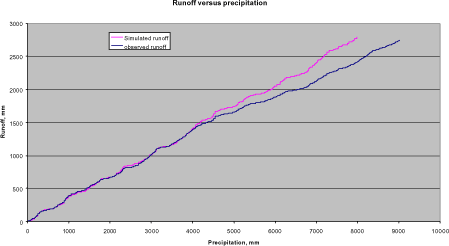
Figure 2 Runoff at the downstream station of Odder Bæk plotted against accumulated precipitation. Up to around Sept. 1994, the precipitation data stem from the local station. After this date, the precipitation file was generated as a mixture of averages of other stations. There is a clear discrepancy between the first and the last part of the curve.
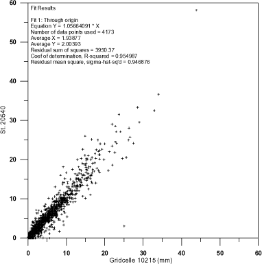
Figure 3 Precipitation station 20540 plotted against grid precipitation for grid cell 10215.
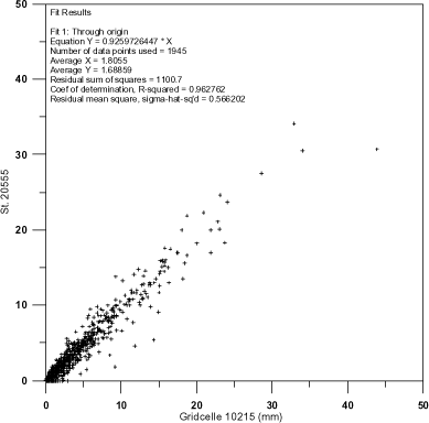
Figure 4 Precipitation station 20555 plotted against grid precipitation for grid cell 10215.
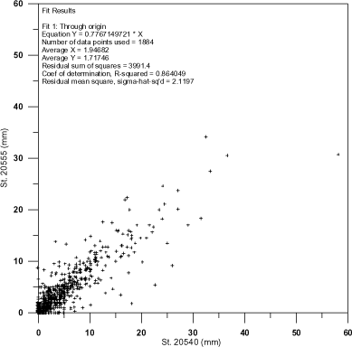
Figure 5 Precipitation station 20555 plotted against precipitation station 20540.
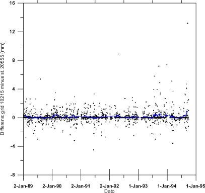
Figure 6 Daily differences between grid precipitation and station 20555.
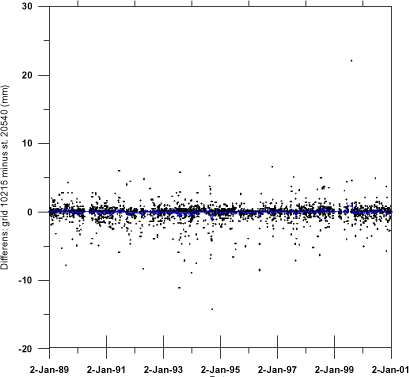
Figure 7 Daily differences between grid precipitation and station 205540.
Version 1.0 November 2004, © Danish Environmental Protection Agency