Calibration of Models Describing Pesticide Fate and Transport in Lillebæk and Odder Bæk Catchment
Appendix B
1 Derivation of Parameters for the Unsaturated Zone
1.1 Hydraulic parameters
Lillebæk
The starting point for the choice of retention curves was the measured curves from the six station fields (Nielsen, 1999), earlier measured retention curves (Jensen and Madsen, 1990) and experiences from earlier calculations in Lillebæk (Sørensen and Styczen, 1994).
The division of the profiles in horizons is shown in Figure 1.
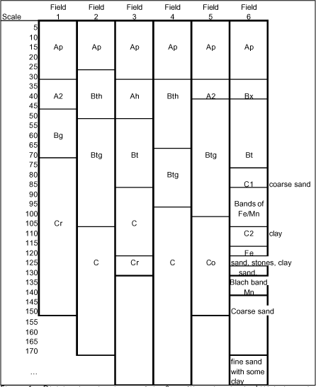
Figure 1 Division into horizons of the 6 profiles taken in the Lillebæk catchment.
The properties of the investigated profiles are shown in Table 2. All profiles have a ploughing layer of about 30 cm on top, and this is followed by Bt or Btg horizons at some depth, with higher clay content and sometimes glay features. Transformation to the clayey-material takes place between 25 and 45 cm depth.
In five out of 6 profiles, the B-horizon is limited downwards by a C-horizon with low permeability. The texture is variable; one contains significantly more silt than the others do. The last C-horizon starts in 75 cm's depth and consists of layered material, shifting between very sandy and more clayey material with a very high and very low conductivity respectively. In the 6th profile, at 1.7 m, a sandy layer with relatively high conductivity is found.
The measured retention curves for the A-horizons are difficult to use directly. shows bulk densities measured in the fields at three different occasions.
Table 1 Measurements of volume weight of the Ap-horizons of the station fields.
| Original measurements (Jensen and Madsen, 1990) |
Measurements carried out by the county of Funen, (Sørensen and Styczen, 1994) |
Recent measurements (Nielsen; 1999) |
|
| Field 1 | 1.83 | 1.45 | 1.65 |
| Field 2 | 1.69 | 1.40 | 1.75 |
| Field 3 | 1.77 | 1.46 | 1.70 |
| Field 4 | 1.64 | 1.43 | |
| Field 5 | 1.57 | 1.42 | |
| Field 6 | 1.61 | 1.38 |
It is obvious that the total porosity is very tillage dependent, and that some of the high densities recorded are unrealistic as average values of the plough layer (probably compacted by traffic). Field number 6 had fodder beets removed before the 1999-measurement, and that has influenced the density significantly.
The measured retention curves (Nielsen, 1999) of the Ap-horizons are shown in Figure 2. For modelling purposes, the curves of the Ap horizons of station 1, 2, 3, 5 and 6 have been aggregated, and saturated water content of 45 % has been assumed. This corresponds to a density of 1.4-1.45, which is a realistic value for these soils.
Curve number 4 is kept unchanged due to the fact that this soil contains more organic matter than the rest.
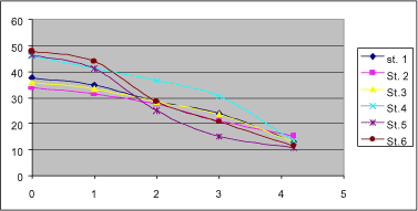
Figure 2 Retention curves of the Ap-horizons of the 6 station fields of Lillebæk.
The A2-horizon of profile 1 appears compacted, just as the Ap-horizon on the same field. Other properties are almost identical with the A2-horizon on field 5. The retention curve of St 5, A2 is therefore used to represent both horizons.
The Bh-horizon in field 2 has a volume weight of 1.74 g/cm3, which is almost inhibitive to roots, and probably not realistic as a general feature on an ordinary agricultural soil at 25 cm depth. The general properties are almost identical to Field 5, horizon Btg, and the retention properties of this soil are used to represent both horizons. On all other B-horizons, the retention data are used directly.
With respect to the C-horizons, the types have been divided into 4:
- a moraine type, which is characteristic of the C-horizon in field 1, 2 and 3, as well as the clay layer of field 6. It contains 19-23% clay and 20-25% silt.
- a silty type, which is the C-horizon in field 4. It contains more than 60% silt.
- a clayey type, which is the C-horizon of field 5. It contains about 30% clay and 20% silt.
- a sandy type, which is the lower horizon in field 6. It only contains 8% clay. The same curves are used in the sandy layer of the same field.
The hydraulic conductivities have been distributed independently of the retention curves. Generally this means that although two soils may have the same retention curve, they may differ with respect to hydraulic conductivity. As far as possible, the measured values were used as the basis for parameterisation. It was assumed that the lowest values measured represent the matrix conductivity. The geometrical average of the measured conductivity-values was then considered to be the sum of a macropore- and matrix conductivity.
Ksat (bulk) = Kmacropore + Kmatrix
Table 4-Table 8 show the estimation of conductivity values for Lillebæk. The grayed out values are the ones considered for matrix conductivity.
Table 2 Soil Texture and measured retention properties for Lillebæk.
Table 3 Soil Texture and measured retention properties for Odder Bæk.
Table 4 Measured and calculated hydraulic conductivity values for Lillebæk, Ap-horizons. Values are in mm/hr. The values for the first 3 horizons were averaged, and for the last two estimated together.
Table 5 Measured and calculated hydraulic conductivity values for Lillebæk, Second -horizons. Values are in mm/hr. Lowest values for horizon 2-4 were used to calculate matrix conductivity.
Table 6 Measured and calculated hydraulic conductivity values for Lillebæk, B/B2-horizons. Values are in mm/hr. Lowest values for horizon 2-4 were used to calculate matrix conductivity.
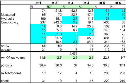
Table 7 Measured and calculated hydraulic conductivity values for Lillebæk, C-horizons. Values are in mm/hr. Lowest values for horizon 1-3 were used to calculate matrix conductivity. The corresponding conductivity of the macropores was set to 135 mm/hr.
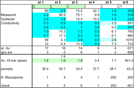
Table 8 Measured and calculated hydraulic conductivity values for Lillebæk, C2-horizons. Values are in mm/hr.
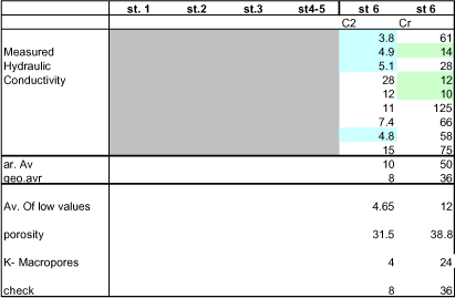
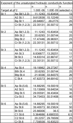
Table 9 Exponent of the unsaturated hydraulic conductivity function for the Lillebæk profiles and horizons.
Odder Bæk
For Odder Bæk, there are clearly distinguishable soil types in the catchment according to the soil map (see Figure 3.4 in the main report. The properties of the profiles investigated are shown in Table 3. However, as there was an unclear relationship between the map information, the profile descriptions and the geological information, it was not possible to use the data directly. A different approach had to be developed.
The area is divided into 6 soil groups. The distribution of horizons is shown in Table 10 and Figure 3.
Table 10 Soil types in Odder Bæk.
| Coarse sand 1 (JB 1+3) |
Fine Sand 2 | Sand on Clay 3 | Organics on clay 4, 5 | Organics on sand 7 | |
| A | St 1 (Ap) | St 1 (Ap) | St 3 Ap | Organic | Organic |
| B | St 2 B | St 1 B | |||
| C | St 2 C | St 1 C | St 4 C (modified) | St 4 C (modified) | Station 2C |
| St 2 C2 |
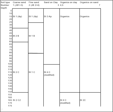
Figure 3 Depth of horizons in Odder Bæk profiles.
Originally measured retention curves were used. However, through the calibration it became clear that some of the curves were not appropriate as averages for the catchment. For the coarse sand, the measured retention curve for the C-horizon contained too much water between pF 1 and 2, meaning that the simulated groundwater variations were extremely small, and not in tune with observations. A curve was created from curve 5C and 2C (Both JB2's) that produced better correspondence with observed groundwater variations. For the same soil, the values for the B-horizon was compared to retention curves generated with the HYPRES (Wösten et al., 1998) pedotransfer-function for the same texture. The pedotransfer-values were used instead. No local measurements exist for the organic soils. The HYPRES default description was therefore used. The clay horizon (B/C) for "Sand on Clay" and "Organics on Clay" was created by comparing the curves from Station 3B and C and 4B2 and C. In the interval between saturation and pF2, it follows values of 3B, 3C and 4C, and below pF2, it follows the curve 4C. This also produced the best fit with groundwater variations. The values of the modified curves are shown in .
Table 12 Retention curves that differ from the original measurements for Odder Bæk.
| pF | Organics | 2B | 2C2 | St 4 C modified |
| 0 | 0,766 | 0,42 | 0.350 | 0,372 |
| 1 | 0,756 | 0,365 | 0.320 | 0,364 |
| 2 | 0,743 | 0,184 | 0,210 | 0,353 |
| 3 | 0,708 | 0,076 | 0,066 | 0,292 |
| 4.2 | 0,663 | 0,03 | 0,026 | 0,164 |
| 5 | 0,604 | 0,019 | 0,020 | 0,100 |
With respect to hydraulic conductivities for the unsaturated zone, the original values are shown in Table 13. The conductivities that were used for each of the horizons defined in Table 10 is shown in Table 14 together with the exponent of the hydraulic conductivity function.
Table 13 Hydraulic conductivity in Odder Bæk, average of 9 measured values, mm/hour.
| Aritmetric | Geometric | Ks | |||
| average | average | m/s | |||
| 1 | Ap | 94 | 49 | 1.36 E-5 | |
| A2 | 92 | 49 | 1,36E-5 | ||
| B | 115 | 102 | 2,83E-5 | ||
| C | 44 | 41 | 1,14E-5 | ||
| 2 | Ap | 51 | 46 | 1.27E-5 | |
| B | 222 | 196 | 5,44E-5 | ||
| B/C | 643 | 588 | 1,63E-4 | ||
| C | 824 | 767 | 2,13E-4 | ||
| 3 | Ap | 54 | 46 | 1.27E-5 | |
| B | 37 | 14 | 3.89E-6 | ||
| C | 1,9 | 1,6 | 4,44E-7 | ||
| 4 | Ap | 197 | 137 | 3.81E-5 | |
| B1 | 241 | 155 | 4,31E-5 | ||
| B2 | 6,5 | 3,8 | 1,05E-6 | ||
| C | 5,8 | 3,1 | 8,61E-7 | ||
| 5 | Ap | 102 | 78 | 2,17E-5 | |
| A/B | 76 | 72 | 2,00E-5 | ||
| B | 122 | 101 | 2,81E-5 | ||
| C | 76 | 72 | 2,00E-5 | ||
| 6 | Ap | 17 | 15 | 4,17E-6 | |
| E | 111 | 97 | 2,69E-5 | ||
| B | 24 | 20 | 5,56E-6 | ||
| C | 2,1 | 1,9 | 5,28E-7 | ||
Table 14 Calibrated values for Ks and n.
| Ks | n | |
| Station 1 (Ap) | 7.41E-06 | 11.3 |
| Station 1 (B) | 1.64E-05 | 8.28 |
| Station1(C) | 6.60E-06 | 9.55 |
| Station 2 (B) | 5.44E-05 | 12.0 |
| Station 2 (C) | 2.13E-04 | 16.0 |
| Station 2 (C2) | 2,00 E-3 | 16.5 |
| Station 3 (Ap) | 1.28E-05 | 17.0 |
| Station 4 (C) modified | 1,03 E-6 | 6 |
| Organics | 9,26E-7 | 25 |
1.2 Soil Parameters used for pesticide-relevant transformations
Pesticide simulations require specification of a number of soil parameters. The sorption values may depend on organic matter or clay content. For calculation of degradation rates, the moisture content at saturation, pF1 or pF2 are relevant. The bulk density is required for some calculations as well.
The actual values selected for these parameters are shown in Table 15 or the Lillebæk soils and in for the Odder Bæk soils.
Table 15 Carbon and clay content, bulk density and key moisture contents used to transform pesticide parameters appropriately for the different Lillebæk soils.
| Water content | ||||||||
| Soil | horizon | depth, cm | C, % | clay, % | θsat | θpF1 | θpF2 | Bulk density |
| Lillebæk, plot 1 | Ap | 0-30 | 0.99 | 16.5 | 46.4 | 41.2 | 25 | 1.42 |
| A2 | 30-40 | 1.16 | 15.9 | 36.6 | 33.6 | 27.5 | 1.68 | |
| 40-45 | 1.16 | 15.9 | 36.6 | 33.6 | 27.5 | 1.68 | ||
| Bg | 45-50 | 0.87 | 19.8 | 38.4 | 36.9 | 29.2 | 1.63 | |
| 50-70 | 0.87 | 19.8 | 38.4 | 36.9 | 29.2 | 1.63 | ||
| Cr | 70-80 | 0.12 | 19.7 | 35.4 | 34.6 | 29.8 | 1.71 | |
| -150 | 80-100 | 0.12 | 19.7 | 35.4 | 34.6 | 29.8 | 1.71 | |
| 100-105 | 0.12 | 19.7 | 35.4 | 34.6 | 29.8 | 1.71 | ||
| 105-120 | 0.12 | 19.7 | 35.4 | 34.6 | 29.8 | 1.71 | ||
| 120-170 | 0.12 | 19.7 | 35.4 | 34.6 | 29.8 | 1.71 | ||
| >170 | 0.12 | 19.7 | 35.4 | 34.6 | 29.8 | 1.71 | ||
| Lillebæk, plot 2 | Ap (25) | 0-30 | 0.99 | 18.6 | 46.4 | 41.2 | 25 | 1.42 |
| Bth (52) | 30-40 | 0.35 | 25.9 | 34.4 | 32.8 | 30.2 | 1.74 | |
| 40-45 | 0.35 | 25.9 | 34.4 | 32.8 | 30.2 | 1.74 | ||
| 45-50 | 0.35 | 25.9 | 34.4 | 32.8 | 30.2 | 1.74 | ||
| Btg | 50-70 | 0.17 | 21.7 | 36.3 | 31.8 | 28.7 | 1.69 | |
| 70-80 | 0.17 | 21.7 | 36.3 | 31.8 | 28.7 | 1.69 | ||
| 80-100 | 0.17 | 21.7 | 36.3 | 31.8 | 28.7 | 1.69 | ||
| 100-105 | 0.17 | 21.7 | 36.3 | 31.8 | 28.7 | 1.69 | ||
| C | 105-120 | 0.12 | 22.7 | 35.7 | 33.4 | 31 | 1.7 | |
| -170 | 120-170 | 0.12 | 22.7 | 35.7 | 33.4 | 31 | 1.7 | |
| >170 | 0.12 | 22.7 | 35.7 | 33.4 | 31 | 1.7 | ||
| Lillebæk. plot 3 | Ap (32) | 0-30 | 1.16 | 15.4 | 46.4 | 41.2 | 25 | 1.42 |
| Ah | 30-40 | 0.64 | 21.6 | 42.3 | 33.1 | 25.2 | 1.53 | |
| 40-45 | 0.64 | 21.6 | 42.3 | 33.1 | 25.2 | 1.53 | ||
| 45-50 | 0.64 | 21.6 | 42.3 | 33.1 | 25.2 | 1.53 | ||
| Bt (83) | 50-70 | 0.23 | 23.6 | 37 | 31.6 | 27.8 | 1.67 | |
| 70-80 | 0.23 | 23.6 | 37 | 31.6 | 27.8 | 1.67 | ||
| C | 80-100 | 0.12 | 19.4 | 34.4 | 30.4 | 27.5 | 1.74 | |
| 100-105 | 0.12 | 19.4 | 34.4 | 30.4 | 27.5 | 1.74 | ||
| 105-120 | 0.12 | 19.4 | 34.4 | 30.4 | 27.5 | 1.74 | ||
| Cr | 120-170 | 0.12 | 19.4 | 34.4 | 30.4 | 27.5 | 1.74 | |
| -200 | >170 | 0.12 | 19.4 | 34.4 | 30.4 | 27.5 | 1.74 | |
| Lillebæk. plot 4 | Ap | 0-30 | 1.8 | 17.7 | 45.9 | 41.3 | 36.6 | 1.43 |
| Bth (67) | 30-40 | 0.23 | 24.8 | 36.9 | 31.4 | 26.3 | 1.67 | |
| 40-45 | 0.23 | 24.8 | 36.9 | 31.4 | 26.3 | 1.67 | ||
| 45-50 | 0.23 | 24.8 | 36.9 | 31.4 | 26.3 | 1.67 | ||
| 50-70 | 0.23 | 24.8 | 36.9 | 31.4 | 26.3 | 1.67 | ||
| Btg (97) | 70-80 | 0.12 | 21.6 | 34.6 | 33.9 | 28.6 | 1.73 | |
| 80-100 | 0.12 | 21.6 | 34.6 | 33.9 | 28.6 | 1.73 | ||
| C | 100-105 | 0.06 | 14.4 | 37.7 | 37.6 | 35.9 | 1.65 | |
| 105-120 | 0.06 | 14.4 | 37.7 | 37.6 | 35.9 | 1.65 | ||
| 120-170 | 0.06 | 14.4 | 37.7 | 37.6 | 35.9 | 1.65 | ||
| >170 | 0.06 | 14.4 | 37.7 | 37.6 | 35.9 | 1.65 | ||
| Lillebæk. plot 5 | Ap | 0-30 | 1.22 | 14.8 | 46.4 | 41.2 | 25 | 1.42 |
| A2 (38) | 30-40 | 1.16 | 14.8 | 40.4 | 37 | 26.6 | 1.58 | |
| Btg | 40-45 | 0.29 | 24.8 | 39.3 | 39.2 | 31.4 | 1.61 | |
| 45-50 | 0.29 | 24.8 | 39.3 | 39.2 | 31.4 | 1.61 | ||
| 50-70 | 0.29 | 24.8 | 39.3 | 39.2 | 31.4 | 1.61 | ||
| 70-80 | 0.29 | 24.8 | 39.3 | 39.2 | 31.4 | 1.61 | ||
| 80-100 | 0.29 | 24.8 | 39.3 | 39.2 | 31.4 | 1.61 | ||
| Co | 100-105 | 0.17 | 30.5 | 38.1 | 37.6 | 34.1 | 1.64 | |
| -150 | 105-120 | 0.17 | 30.5 | 38.1 | 37.6 | 34.1 | 1.64 | |
| 120-170 | 0.17 | 30.5 | 38.1 | 37.6 | 34.1 | 1.64 | ||
| >170 | 0.17 | 30.5 | 38.1 | 37.6 | 34.1 | 1.64 | ||
| Lillebæk. plot 6 | Ap (28) | 0-30 | 1.22 | 17 | 46.4 | 41.2 | 25 | 1.42 |
| Bx | 30-40 | 0.46 | 21.7 | 32.4 | 31.6 | 29.1 | 1.79 | |
| Bt (75) | 40-45 | 0.17 | 20.5 | 37.1 | 36.5 | 29.8 | 1.67 | |
| 45-50 | 0.17 | 20.5 | 37.1 | 36.5 | 29.8 | 1.67 | ||
| 50-70 | 0.17 | 20.5 | 37.1 | 36.5 | 29.8 | 1.67 | ||
| Co | 70-80 | 0.06 | 4.9 | 42.5 | 36.1 | 7.5 | 1.52 | |
| 80-100 | 0.06 | 8.2 | 38.8 | 34.9 | 18.4 | 1.62 | ||
| clayey band | 100-105 | 0.06 | 14.4 | 31.5 | 30.1 | 24.6 | 1.82 | |
| 105-120 | 0.06 | 4.9 | 42.5 | 36.1 | 7.5 | 1.52 | ||
| 120-170 | 0.06 | 4.9 | 42.5 | 36.1 | 7.5 | 1.52 | ||
| Cr (250) | >170 | 0 | 8.2 | 38.8 | 34.9 | 18.4 | 1.62 | |
Table 16 Carbon and clay content, bulk density and key moisture contents used to transform pesticide parameters appropriately for the different Odder Bæk soils.
| Water content | ||||||||
| Soil | horizon | depth | C, % | clay, % | θsat | θpF1 | θpF2 | Bulk density |
| Odder Bæk | 1Ap | 0.25 | 2.32 | 6.4 | 46.7 | 39.7 | 30.8 | 1.41 |
| coarse sand on clay | 0.35 | 1.22 | 6.4 | 46.7 | 39.7 | 30.8 | 1.41 | |
| 2B | 0.6 | 0.87 | 5.7 | 42 | 36.5 | 18.4 | 1.38 | |
| 2C | 0.8 | 0.06 | 3.9 | 39.2 | 35.7 | 6.3 | 1.61 | |
| 2C | 1 | 0.06 | 3.9 | 39.2 | 35.7 | 6.3 | 1.61 | |
| 2C | 1.5 | 0.06 | 3.9 | 39.2 | 35.7 | 6.3 | 1.61 | |
| 2C2 | >1.5 | 0.09 | 4.25 | 35 | 32 | 21 | 1.655 | |
| Fine sand 2 | St1 (Ap) | 0.25 | 2.32 | 6.4 | 46.7 | 39.7 | 30.8 | 1.41 |
| St 1 B | 0.35 | 1.22 | 5.2 | 43.1 | 36.4 | 21.7 | 1.51 | |
| St 1 B | 0.6 | 0.41 | 5.2 | 43.1 | 36.4 | 21.7 | 1.51 | |
| St 1 B | 0.8 | 0.41 | 5.2 | 43.1 | 36.4 | 21.7 | 1.51 | |
| St 1. C | 1 | 0.12 | 5.1 | 39 | 33.8 | 20 | 1.62 | |
| 1.5 | 0.12 | 5.1 | 39 | 33.8 | 20 | 1.62 | ||
| >1.5 | 0.12 | 5.1 | 39 | 33.8 | 20 | 1.62 | ||
| Sand on clay | St 3 Ap | 0.25 | 2.55 | 4.7 | 49.7 | 41.8 | 30.6 | 1.33 |
| St 3 Ap | 0.35 | 1.22 | 4.7 | 49.7 | 41.8 | 30.6 | 1.33 | |
| St 3 Ap | 0.6 | 0.17 | 4.7 | 49.7 | 41.8 | 30.6 | 1.33 | |
| St 3 Ap | 0.8 | 0.17 | 4.7 | 49.7 | 41.8 | 30.6 | 1.33 | |
| St 3 Ap | 1 | 0.17 | 4.7 | 49.7 | 41.8 | 30.6 | 1.33 | |
| St 4C mod | 1.5 | 0.17 | 20.1 | 37.2 | 36.4 | 35.3 | 1.64 | |
| St 4C mod | >1.5 | 0.17 | 20.1 | 37.2 | 36.4 | 35.3 | 1.64 | |
| Soil | horizon | depth | C, % | clay, % | θsat | θpF1 | θpF2 | Bulk density |
| Organics on clay | Organic | 0.25 | 6.96 | 8 | 76.6 | 75.6 | 74.3 | 0.86 |
| Organic | 0.35 | 6.96 | 8 | 76.6 | 75.6 | 74.3 | 0.86 | |
| Organic | 0.6 | 6.96 | 8 | 76.6 | 75.6 | 74.3 | 0.86 | |
| Organic | 0.8 | 6.96 | 8 | 76.6 | 75.6 | 74.3 | 0.86 | |
| Organic | 1 | 6.96 | 8 | 76.6 | 75.6 | 74.3 | 0.86 | |
| Organic | 1.5 | 6.96 | 8 | 76.6 | 75.6 | 74.3 | 0.86 | |
| St 4C mod | >1.5 | 0.17 | 20.1 | 37.2 | 36.4 | 35.3 | 1.64 | |
| Organics on clay | Organic | 0.25 | 6.96 | 8 | 76.6 | 75.6 | 74.3 | 0.86 |
| Organic | 0.35 | 6.96 | 8 | 76.6 | 75.6 | 74.3 | 0.86 | |
| Organic | 0.6 | 6.96 | 8 | 76.6 | 75.6 | 74.3 | 0.86 | |
| Organic | 0.8 | 6.96 | 8 | 76.6 | 75.6 | 74.3 | 0.86 | |
| Organic | 1 | 6.96 | 8 | 76.6 | 75.6 | 74.3 | 0.86 | |
| Organic | 1.5 | 6.96 | 8 | 76.6 | 75.6 | 74.3 | 0.86 | |
| St. 2 C | >1.5 | 0.06 | 3.9 | 39.2 | 35.7 | 6.3 | 1.61 | |
1.3 References
Nielsen, O.H. (1999): Rapport om Jordfysiske Målinger i Landovervågningsoplandet på Fyn. November 1999. Danmarks JordbrugsForskning, Afdeling for Plantevækst og Jord.
Jensen, N.H. and Madsen, H.B. (1990): Jordprofilundersøgelse i vandmiljøovervågningsopland. Statens Planteavlsforsøg, Afdelingen for Arealdata og Krotlægning. pp 17. bilag.
Sørensen, H.R. and Styczen, M (1994): Simulation of Water and Nitrate Movements in the Lillebaek Catechment on Funen. Danish Hydraulic Institute, December, 1994. 77 pp.
Wösten, J.H.M, lilly, A., Nemes, A., and Le Bas, C. (1998): Using existing soil data to derive hydraulic parameters for simulation models in environmental studies and in land use planning.. Final Report on the European Union Funded Project. Report156. DLO-Staring Centre, Wageningen. 106 pp.
Version 1.0 November 2004, © Danish Environmental Protection Agency