|
| Front page | | Contents | | Previous | | Next |
Effects of Pesticides on Bombina bombina in Natural Pond Ecosystems
2 Localities
2.1 Criteria for selection of localities
In 1993, 8 ponds (P1-P8) in agricultural areas were selected for experiments and an additional pond (P9) was included in 1994-95. Two ponds in uncultivated areas were included for
the investigation in 1994-95 (P10-P11). Except for pond P8 on the east coast of Fyn Bombina bombina was found in all the ponds. B. bombina became extinct in P8 in the middle of
the 1970's.
Criteria
The 9 ponds (P1-P9) were chosen according to the following criteria:
- The ponds should be representative for Danish ponds with regard to size of buffer zone (1-10 m). At least 180° of the individual buffer zones had to be vegetated with only herbs
and grass and not trees and bushes.
- The ponds should be fully exposed to the sun and have a shallow zone.
- The ponds should be naturally eutrophic.
- To ensure a good and even water quality all ponds should have been dredged in the period 1983-90 and should be without an inlet.
- The surrounding fields should be cultivated conventionally with a typical Danish crop production and pesticide use.
2.2 Description of localities
On Avernakø, a small island with small family farms located south of Fyn, 8 of the ponds were chosen (P1-P7, P9) (figure 2.1). On a large manor, Juelsberg, on the east coast of Fyn
pond P8 was found (figure 2.2). The two ponds in uncultivated areas, P10 & P11, were chosen on the east coast of Fyn (figure 2.2). In all ponds except P8 the top layer of sediment
was removed once during the period 1983-90 (table 2.1). The ponds in the uncultivated area, P10 and P11, were dug in 1987 and 1990 respectively. Pond P5 received surface water
from P3 and drainage water from 2-3 hectares of farm land through an inlet. There were no inlets to the other ponds.
Table 2.1
Physical description of ponds.
Fysisk beskrivelse af vandhuller.
| Pond |
Area (m2) |
Dredged (year) |
Open water (%) |
| P1 |
750 |
1986 |
10 |
| P2 |
170 |
1983 |
0 |
| P3 |
940 |
1989 |
3-8 |
| P4, 1993 |
140 |
1989 |
51 |
| P4, 1994-95 |
1,050 |
1989 |
6-7 |
| P5 |
170 |
1989 |
0 |
| P6 |
640 |
1983 |
11-20 |
| P7 |
300 |
1989 |
8-16 |
| P8 |
50 |
- |
0 |
| P9 |
80 |
1989 |
0 |
| P10 |
40 |
1987 (newly dug) |
0 |
| P11 |
1,100 |
1990 (newly dug) |
11-12 |
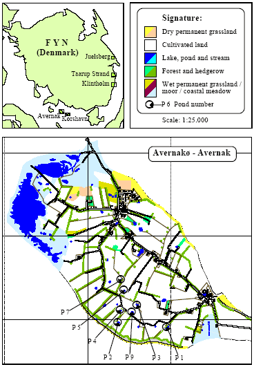
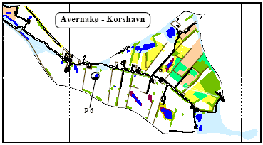
Figure 2.1
Overview of localities. Location of ponds on Avernakř (P1-P7, P9).
Oversigt over lokaliteter. Beliggenhed af vandhuller på Avernakø (P1-P7, P9).
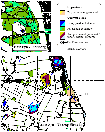
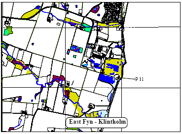
Figure 2.2
Location of ponds on the east coast of Fyn (P8, P10-P11).
Beliggenhed af vandhuller på Østfyn (P8, P10-P11).
| Front page | | Contents | | Previous | | Next | | Top |
Version 1.0 October 2004, © Danish Environmental Protection Agency
|