Model assessment of reductive dechlorination as a remediation technology for contaminant sources in fractured clay: Case studies
5 Gl. Kongevej
- 5.1 Characterization of the contaminant source
- 5.2 Geological characterization – Fractures distribution
- 5.3 Hydrogeological characterization
- 5.4 Enhanced reductive dechlorination
- 5.5 Model configuration and scenarios
- 5.6 Model results
5.1 Characterization of the contaminant source
The contamination at Gl. Kongevej consists in one hotspot, where most of the contaminant mass is located in the saturated zone. The contamination source is both in the clayey till and the upper aquifer. Nevertheless the flow in the upper aquifer is very low and most of the contaminant flux to the regional aquifer is believed to come from vertical flux through the clayey till. Therefore only the clay layer and the regional aquifer are taken into account in this study. Furthermore no reductive dechlorination has been observed at the site and the main pollutant is TCE.
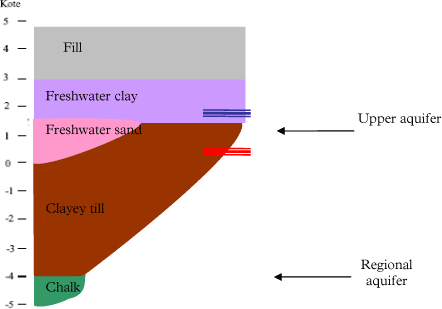
Figure 5.1 - Geological cross section at Gl. Kongevej. In blue the water table of the upper aquifer, in red of the regional aquifer.
Most of the contamination is located in the clayey till between 3 and 8 m below surface (mbs) over an area of 140 m². The total mass of contaminant in the source zone is estimated to be 30-40 kg (Miljøkontrollen 2006). Assuming a sorption coefficient Kd of 0.6 L/kg, a bulk density ρb of 1.96 kg/L and a porosity φ of 0.3, the average aqueous concentration in the source zone is 30-40 mg/L. Concentrations up to 3100 µg/L are found in the chalk aquifer due to leaching from the source zone.
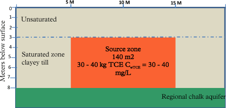
Figure 5.2 - Simplified geology and source zone at Gl. Kongevej
5.2 Geological characterization – Fractures distribution
As no field data is available regarding fractures in the clayey till, statistical data has to be used to assess the fracture frequency. At Vesterbro, the clayey till is a basal till and systematic fractures can be expected (Miljøstyrelsen 2008b). Based on linear extrapolation of data in Figure 4.3, a vertical fracture spacing of 2 meters (at 8 meters depth) is assumed at Gl. Kongevej.
5.3 Hydrogeological characterization
The vertical gradient iv through the clay layer varies between 0.4 and 1.7, with an average of 1 m/m (Miljøkontrollen 2004c), but there is no data available concerning the hydraulic conductivity of the clayey till at this site. However the net recharge rate at the site is assessed around 100 mm/year (Miljøkontrollen 2004c), which corresponds, together with the vertical gradient to a bulk hydraulic conductivity Kb of 3.2*10-9 m/s. The fracture aperture (2b) is estimated to 22µm using the same procedure as for Vadsbyvej.
Concerning the regional aquifer, the following parameters are available in (Miljøkontrollen 2004c):
- effective porosity φaq = 0.15
- hydraulic horizontal gradient iaq = 0.003
- hydraulic conductivity Kaq = 5*10-5 m/s
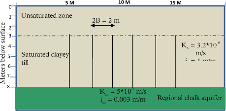
Figure 5.3 - Simplified geology and hydrogeology at Gl. Kongevej
5.4 Enhanced reductive dechlorination
Remediation based on ERD was started in 2006 in the source zone with the injection of molasses and specific degraders (including bacteria of the genus Dehalococcoides) every 0.25 m between 2 and 7 mbs (Miljøkontrollen 2006). The injection was performed using a direct push with Geoprobe and the injected material is assumed to spread in the naturally occurring heterogeneities in the till (fractures and/or sand stringers).
5.5 Model configuration and scenarios
As for Vadsbyvej, the model is used for a baseline scenario (no remediation) and different remediation scenarios corresponding to different possibilities for dechlorination locations.
- Baseline = no dechlorination occurs in the source zone.
- Remediation A = degradation in the clay at intervals of 0.25 m, corresponding to the location of injection of molasses and degraders (injection depths)
- Remediation B = degradation at the injection depths (every 0.25 m) and in a reaction zone, which is formed in the 10 cm of the matrix surrounding the injection depth.
- Remediation C = degradation in the entire matrix
If the interval between the injection depths is reduced to 10 cm, remediation B will be equivalent to C.
5.6 Model results
5.6.1 Model parameters
Table 4 - Model parameters for Gl. Kongevej
| Transport parameters | Value | Reference | |
| Fracture spacing 2B [m] | 2 | See Section 5.2 | |
| Fracture aperture 2b [µm] | 22 | See Section 5.3 | |
| Vertical hydraulic gradient Iv [m/m] | 1 | (Miljøkontrollen 2004c) | |
| Bulk hydraulic conductivity Kb [m/s] | 3.2*10-9 | See Section 5.3 | |
| Velocity in fracture vf [m/y] | 9174 | vf = KbI·2B/2b | |
| Matrix porosity φ | 0.3 | assumed | |
| Bulk density ρb [kg/L] | 1.96 | ||
| Tortuosity τ | 0.3 | τ = φ (Parker et al. 1994) | |
| Free diffusion coefficient D*i [m²/y] | (US EPA 2009) | ||
| PCE | 0.018 | ||
| TCE | 0.020 | ||
| DCE | 0.022 | ||
| VC | 0.026 | ||
| ETH | 0.033 | ||
| Sorption coefficient Kdi [L/kg] | See Section 4.1 | ||
| PCE | 1.4 | ||
| TCE | 0.6 | ||
| DCE | 0.12 | ||
| VC | 0.04 | ||
| ETH | 0 | ||
| Dispersivity in fracture [m] | 0.1 | assumed | |
| Biogeochemical parameters | |||
| Maximum growth rate µi [1/d] | |||
| TCE | 2 | (Miljøstyrelsen 2008a) | |
| DCE | 0.38 | ||
| VC | 0.14 | ||
| Specific yield Y [cell·µmol/L] | 5.2*108 | ||
| Biomass concentration X [cell/L] | 109 | Measured (Region Hovedstaden 2008a) |
|
5.6.2 Mass removal and contaminant flux in the source zone
The source depletion and contaminant flux as a function of time are compared for the different scenarios in Figure 5.4 and Figure 5.5. The scenario with degradation at injection depths only (A) does not differ much from the baseline scenario, in terms of both mass removal and flux reduction. Furthermore it is shown that the contaminant flux entering the regional aquifer Figure 5.5 is expected to decrease quickly in response to clean water flushing in the first 20 years.
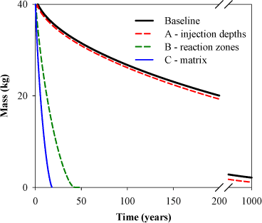
Figure 5.4 - Mass removal with time at Gl. Kongevej. Note the break on the x-axis
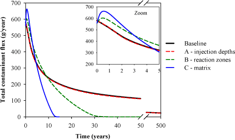
Figure 5.5 - Contaminant flux with time at Gl. Kongevej. Note the different axis scales.
In the presence of a reaction zone around the injection depths (B), the mass removal occurs significantly faster (31 years). This cleanup time reduces to 13 years when the dechlorination is assumed to occur in the whole system (C). Furthermore it can be seen in Figure 5.5, the total contaminant flux increases after injection when dechlorination occurs in the matrix (B and C) and this flux is higher than in the baseline scenario during the first 5 years. This is the same phenomenon as explained for Vadsbyvej, but the increase is much lower and shorter in this case, due to the lower water flow along the fracture.
As for Vadsbyvej, the remediation scenarios are also assessed for the case of 10 years of treatment (instead of assuming that dechlorination occurs in the system indefinitely), in order to evaluate the risk of rebound of contaminant. It is shown in Figure 5.6 that for remediation C, the contaminant flux remains below the baseline scenario after dechlorination stops, even if a rebound is observed. The difference with Vadsbyvej is mainly due to the fact that 50% of the source after 10 years is composed of ethene (compared to 14% for Vadsbyvej), which corresponds to a dechlorination degree of 78% (compared to 60% for Vadsbyvej).
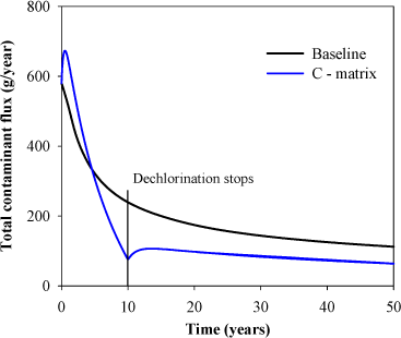
Figure 5.6 - Comparison of flux for baseline scenario and remediation C (where dechlorination stops after 10 years)
5.6.3 Concentration in the regional chalk aquifer
The underlying chalk aquifer is modeled with the simple 2D steady-state cross-section of the aquifer. The choice of a steady-state model in this case is motivated by the high velocity in the aquifer (25 m/year), relatively to the concentration change in the source zone. The contaminant source is defined by the resulting flux from the fracture model.
Table 5 - Parameters for the regional chalk aquifer
| Parameters | Symbol | Value | Unit | Reference |
| Aquifer thickness | Taquifer | 10 | m | (Miljøkontrollen 2004b) |
| Hydraulic conductivity | Kaq | 5*10-5 | m/s | |
| Horizontal hydraulic gradient | Iaq | 0.003 | - | |
| Effective porosity | φaq | 0.2 | - | |
| Recharge rate | R | 100 | mm/year | R = Kb*Iv |
| Flow factor | ff | 2.1 | % | ff = R/(Kaq*Iaq) (Miljøstyrelsen 2008a) |
| Longitudinal dispersvity | αL | Not sensitive | m | (Miljøstyrelsen 2008a) |
| Vertical transverse dispersvity | αT | 0.005 | m | (Hojberg et al. 2005) |
| Source width | W | 12 | m | See Figure 5.2 |
The resulting contaminant plume is shown in Figure 5.7. The average concentration (over 10 meters thickness) is 3% at 5 meters downstream the source and 2.4% at 100 meters downstream.
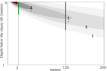
Figure 5.7 - Concentration in the underlying aquifer at steady state, given in percentage of concentration at the outlet of the source
It can be noticed that if instead of averaging the concentration over 10 meters, it is averaged over the thickness of the plume (green lines in Figure 5.7), the concentration becomes higher, with 15.3 % and 5.4% 5 and 100 meters downstream of the source respectively. And if instead of an average concentration, the maximum concentration is chosen, this corresponds to 43% and 10.5% at 5 and 100 meters downstream respectively. Therefore when defining the remediation criteria, regarding water quality in the aquifer, the thickness over which this criteria has to be fulfilled needs to be defined (see further discussion in Section 5.6.5)
5.6.4 Comparison with field data
Since the injection of molasses and specific degraders in 2006, three monitoring campaigns have been performed at the site 11, 14 and 26 months after initiation of the treatment. The concentration of chlorinated solvents is monitored both in the treatment zone (source) and the underlying chalk aquifer. Therefore a comparison can be made with the model results. The results are compared with three boreholes located in the source zone in the clayey till, B34, B35 and B37 and four boreholes located in the underlying aquifer, B103 and B104 are located in the source zone surrounding whereas B101 and B29 are located downstream (see Figure 5.8) (Region Hovedstaden 2008a).
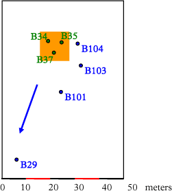
Figure 5.8 – Situation plan of monitoring wells. The contamination source is represented with the orange square and the groundwater flow with the blue arrow. The boreholes B34, B35 and B37 (in green) are located in the source zone, the boreholes B29, B101, B103 and B104 (in blue) are located in the chalk aquifer.
5.6.4.1 Treatment zone
In order to compare the data from the three boreholes with the model, the aqueous concentrations from the simulation are averaged over the whole area and plotted against the measured values (see Figure 5.10). However it has to be kept in mind that the measured concentrations from water sample do not correspond precisely to the simulated aqueous concentrations in the model. The boreholes screen indeed in some high permeability zones present in the clayey till, while the aqueous concentration from the model corresponds to the concentration in the water phase in equilibrium with the surrounding clay. This concept is illustrated in Figure 5.9.
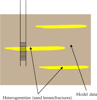
Figure 5.9 - Difference between measured and simulated aqueous concentrations
The results for molar fraction and degree of dechlorination (a and b) show the same trend and are of the same order of magnitude as the measured values, and it can further be seen that the model results from remediation C (degradation in matrix) are very close to the measured values. However this does not necessarily imply that the degradation actually occurs in the whole matrix, but more that degradation actually occurs in the high permeability zones were the boreholes are screened. The borehole screens are only in the high permeability zones, where degradation can occur at higher rates, whereas the model results are averaged over the whole area. Investigations at other field sites (Sortebrovej and Rugårdsvej) have shown that monitoring of aqueous concentrations can overestimate the degree of degradation occurring in the whole system. Therefore only core samples can allow determining the extent of the reaction zones between two injection points (Region Hovedstaden 2008a).
The heterogeneities could also explain the larger aqueous concentrations measured at B34, B35 and B37 in the source zone, compared to the initial average concentration used in the model (Figure 5.10c).
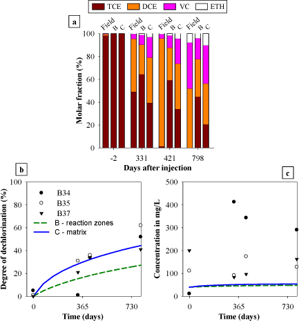
Figure 5.10 - Data at the field site at time -2, 331, 421 and 798 days where reductive dechlorination was enhanced by injection of molasses and specific degraders at day 0, compared with model results from scenarios B and C. a) Molar fraction measured in the source (average of the measurements at the three boreholes) and comparison with model results B and C. b) Degree of dechlorination in the source and comparison with model results B and C. c) Total aqueous concentration in the source compared with model results B and C.
5.6.4.2 Underlying aquifer
The concentrations monitored in the four boreholes in the regional chalk aquifer are compared with the steady-state concentrations resulting from the model for remediation C (Figure 5.11). The model results are of the same order of magnitude, but the trends show some discrepancies. The total aqueous concentrations measured at the field site show an increase with time, whereas the increase in the modeled concentrations is much smaller and shorter. These differences could be due to an underestimation of degradation rates in the source zone, resulting in a limited formation of daughter products compared to what is observed at the site. The variations in water flow (due to variations in gradient and direction) are expected at the field sites and can also explain the differences in the resulting concentrations. Furthermore the larger concentrations observed at the site could indicate that the initial TCE aqueous concentration (40 mg/L) was underestimated at the source zone.
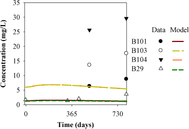
Figure 5.11 - Total aqueous concentration of chlorinated solvents in the underlying aquifer compared with model simulations of remediation C.
5.6.5 Comparison with remediation objectives
The remediation objectives defined for Gl. Kongevej have been presented in Section 2.2.3: the termination criterion was suggested to be the reduction of concentration levels in the treatment zone, and flux to the regional aquifer, by a factor of 50. However these two criteria (on the concentration in the source zone and the flux to the aquifer) are not equivalent, and this is due to the fact that the contaminant flux is depending on the concentration in the fracture outlet and not in the average source concentration.
This criteria means that the concentration (both in the source and at the outlet for the flux criterion) decreases from the assumed initial value of 40 mg/L to 0.8 mg/L (800 µg/L). This value is compared with the two concentrations from the model, the average source concentration (Figure 5.12) and the outlet concentration (Figure 5.13). The concentration at the outlet (and so the flux to the aquifer) decreases faster than the average concentration in the source, therefore the criteria in term of concentration and flux are not equivalent.
From the different simulations, it results that this criterion (for concentration in the source) will be reached after (see Figure 5.12):
- 1300 years for the baseline scenario
- 40 years for remediation B2
- 18 years for remediation C
In term of flux to the aquifer, this criterion will be reached after (Figure 5.13):
- 755 years for the baseline scenario
- 30 years for remediation B2
- 12 years for remediation C
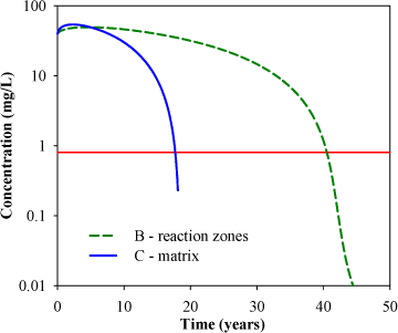
Figure 5.12 - Average aqueous concentration in source zone for remediation B and C. The red line represents the remediation criteria (0.8 mg/L).
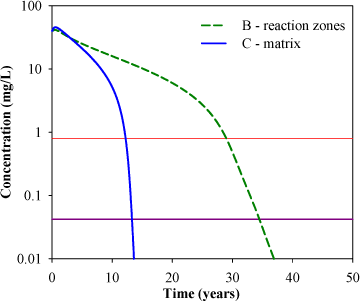
Figure 5.13 - Concentration in the outlet (TCE+DCE+VC) for remediation B and C. The red line represents the actual remediation criterion (0.8 mg/L) and the purple line represents the proposed criterion (0.033 mg/L)
This remediation criterion (in term of flux to the aquifer) would correspond to a concentration of 24 µg/L at the downstream boundary of the treatment zone in the drinking water aquifer (over a depth of 10 meters). This value is far above the drinking water quality standard of 1 µg/L, therefore the model is used to determine an accurate remediation criterion so that the quality standard is fulfilled in a control plan at the downstream boundary of the source (over 10 meters thickness). The quality standard will be reached if the concentration at the outlet equals 33 µg/L (see purple line in Figure 5.13).
For remediation C, this corresponds after 13.4 years of dechlorination to an average aqueous concentration of the chlorinated compounds in the source below 15 mg/L, which corresponds to an average total concentration of 3.3 mg/kg. The initial average total concentration in the source is 30 mg/kg, so this concentration has to be reduced by a factor of 10. The dechlorination degree in the source zone is then above 90%. It can be seen that the actual remediation criterion (an aqueous concentration of 0.8 mg/L in the source zone) is then more conservative than the proposed criterion, but it is not given together with a total concentration. The cleanup increases to 35 years for remediation B (in reaction zones).
If the control plan is not defined over 10 meters thickness but over the thickness of the plume (see Figure 5.7), the quality standard will be reached if the concentration at the outlet equals 6.5 µg/L (after 38 and 13.8 years for remediation B and C respectively). If the criterion is defined on the maximum concentration in the plume instead, the quality standard will be reached if the concentration at the outlet equals 2.3 µg/L (after 40 and 14 years for remediation B and C respectively). It can be seen that for this particular case, the definition of the remediation criterion in the aquifer (choice of the control plan) does not change much the expected cleanup time, because the concentration at the outlet is decreasing very fast from 1 mg/L, but it can be relevant for other cases.
Version 1.0 July 2009, © Danish Environmental Protection Agency