Ship emissions and air pollution in Denmark
4 Air pollution model calculations
- 4.1 Introduction
- 4.2 Interpreting PM2.5 results
- 4.3 Description of the model
- 4.4 Model runs and emission inventories
- 4.5 Results: Concentration levels
- 4.6 Contribution from ships
- 4.7 Comparison with measurements
- 4.8 Scenarios for 2011 and 2020
- 4.9 Concentration levels in Copenhagen
4.1 Introduction
This chapter describes the results from model calculations of the air pollution concentration levels in Denmark using the new and improved emission inventory for ships (AIS-2007). Chapter 2 explained how the ship emission inventory is constructed, and Chapter 3 how it is combined with other ship emission inventories to provide full hemispheric coverage for ship emissions.
The present chapter describes how the ship emissions are combined with emissions from land-based sources and aviation. However, the bulk of the chapter is devoted to a presentation and discussion of results for concentrations.
The model calculations include scenario calculations for the years 2011 and 2020. These scenario calculations are used to assess the effect that international regulations of ship emissions will have for the future air pollution in Denmark, while also taking into account the prospect for other emission sources. The international ship emission regulations were decided within the framework of the International Maritime Organisation (IMO), and are described in Chapter 2. It is important to note that the marine waters around Denmark are SECA areas, and that relatively strict requirements to the sulphur content in fuel apply (and have been assumed to apply for the entire year of 2007). Furthermore, it is assumed that these marine waters will be designated a NOX Emission Control Area (NECA), which will require an 80% reduction in NOX emissions for new ships after 2016.
The chapter contains the following parts:
- Section 4.2 is a brief introduction to interpretation of model results for PM2.5, as the reader should be aware of certain caveats.
- Section 4.3 describes the DEHM model which is used to estimate concentrations.
- Section 4.4 defines the emission inventories used. Previous chapters have discussed the inventories for ships near Denmark. This section sets them in a context where all other emissions sources are also considered.
- Section 4.5 discusses the results in terms of concentration levels for the current (2007) situation. It includes a discussion of the spatial distribution of concentrations, and also gives an overview of the concentration levels of the various pollutants for different regions in Denmark.
- Section 4.6 presents a very central set of results from the study: It quantifies the contribution from ships to the concentration levels in Denmark.
- Section 4.7 compares model results to measurements,
- Section 4.8 presents scenario calculations, demonstrating the combined effect on concentration levels of the IMO measures and the expected changes in land-based emissions.
- Section 4.9 discusses the influence of ship traffic on concentration levels in the Copenhagen area.
4.2 Interpreting PM2.5 results
The main focus during the evaluation of the influence of ship emissions on Danish air pollution has been on SO2, NO2 and primary PM2.5 (directly emitted fine particles). These are the major directly emitted pollutants from ship emissions. In addition to this there is focus on total PM2.5, since PM2.5 is considered to be strongly associated with negative human health effects.
When the results for PM2.5 are evaluated, it is important to bear in mind that PM2.5 consists of many different types of particles. In particular, it should be noted that PM2.5 calculated by the model consists only of primary PM2.5 and the secondary inorganic particles. These are the only parts of PM2.5 that are included in the model, and they account for only about half of PM2.5 in ambient air in Denmark. The remaining parts of the ambient PM2.5 including secondary organic particles are therefore not accounted for in the model calculations presented below. The reason for this is that there is not enough knowledge on the processes forming these secondary organic particles. This is also the case on international level (Yttri et al., 2009)
In order to clarify the distinction between total PM2.5 and the parts calculated by the model we will use the term mPM2.5 for the PM2.5 results from the model.
Measured values of PM2.5 in the ambient air will be higher than mPM2.5, because the measurements also include secondary organic particles. There is some further discussion on this issue later in the chapter, in particular in section 4.9.
4.3 Description of the model
The model calculations to assess air pollution concentration levels have been carried out with the Danish Eulerian Hemispheric Model (DEHM) which was developed at NERI. The model is used for the calculations in the Danish air quality monitoring programmes (Ellermann et al., 2009; Kemp et al; 2008) and has been used for almost a decade in connection with many research programmes carried out at NERI. The performance of the model has been tested in international model intercomparisons, where a high international standard has been confirmed.
DEHM is a Eulerian model that calculates emissions, transport, chemical and physical processes and deposition of air pollution in a three dimensional grid (Figure 4.1). The transport of the air pollution is determined on the basis of the meteorological conditions and takes place in and out of the individual grid cells in the horizontal as well as the vertical directions. Emissions are added to the model in the lowest layers of grid cells in the model. Low sources are added in the bottom layer while high stacks are added in the relevant layers of the model; typical at heights from 150 m to 600 m. The emissions from ships have been added to the bottom layers with an even distribution from the surface and up to 170 m height. This simple approach has been taken because of lack of more detailed information on the effective height of ship emissions.
Deposition of the air pollution is calculated from the concentrations in the lowest layers of the model. The deposited air pollutants are subsequently removed from these grid cells.
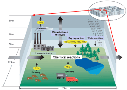
Figure 4.1 Illustration of the principles behind DEHM. For each grid cell the model calculates changes in the concentrations of the air pollutants due to emissions, transport with the wind, mixing between the layers, chemical and physical processes, and finally dry and wet deposition.
DEHM is designed with four different geographical domains with increasing spatial resolution:
- The first domain covers the entire northern hemisphere with a spatial resolution on 150 km x 150 km.
- The second domain covers Europe and some of the western Asiatic countries. This domain has a spatial resolution of 50 km x 50 km. The geographical area and the spatial resolution at this domain corresponds to area and resolution used in the model calculations carried out in connection to the European air monitoring programme EMEP.
- The third domain covers Denmark and the Danish marine areas plus some of the neighbouring countries. The spatial resolution is 17 km x 17 km.
- The fourth domain was recently introduced. It covers Denmark and parts of the Danish marine waters. This domain has a spatial resolution of approximately 6 km x 6 km. This high spatial resolution is needed in order to calculate properly the effects of ship emissions in the narrow Danish straits.
The four domains are shown in Figure 4.2. The four domains are linked in such a way that input data and results are dynamically exchanged between them. In this way the model can cover the entire northern hemisphere, and at the same time provide results for Denmark with a high spatial resolution. The ability to cover a large area and at the same time have high spatial resolution is especially important in this study. One of the reasons for this is that one of the major pollutants from ships is sulphur dioxide (SO2), which is chemically converted to particle bound sulphate (SO4²-) in the atmosphere. Sulphate is long range transported with typical travel distances of up to more than 1000 km. Hence the model needs to cover several thousand kilometres in all directions away from Denmark in order to capture all the sources that can have effect on the air pollution in Denmark. The fact that the Danish straits are typically 5-20 km wide illustrates the need for the high spatial resolution.
In the vertical direction the model covers the lowest 15 km of the atmosphere in 20 layers of grid cells. The lowest layers need the highest resolution and they have a thickness of about 60 m. The upper layers have a thickness of about 2000 m.
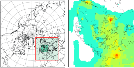
Figure 4.2 Left: The three first domains of DEHM. Right: Model calculated concentrations of sulphur dioxide in 2007 based on the fourth layer of the model. The small grid cells are 6 km x 6 km.
The meteorological input data needed for DEHM have been calculated using the meteorological model called MM5 (Grell et. al., 1995). It is part of the so-called THOR modelling system implemented at NERI (Thor.dmu.dk). All model calculations of air pollution in this project have been carried out using meteorological data for year 2007. In this way the only difference between the calculations for the reference year 2007 and the scenario calculations for 2011 and 2020 will be the changes in the emissions.
4.4 Model runs and emission inventories
Five different sets of model calculations have been carried out using different emission inventories in order to evaluate:
- the effect of the improvements in the emission inventories for ships;
- the contribution from ships to concentration levels;
- the effect of the international regulations aiming at a reduction of the ship emissions in the period up to 2020.
The emission inventories for SO2, NOX, VOC, CO and PM used for the five sets of model calculations are named as follows:
- EMEP-ref: Reference emission inventory based on the original ship emissions from EMEP[6] for 2006 with a spatial resolution of 50 km x 50 km (www.ceip.at). Refers to the situation before SECA requirements for sulphur became effective. Emissions from land-based sources and aviation for 2006 as described below.
- AIS-sp: Special version of the ship emissions based on AIS. This is a pre-SECA scenario. For the Danish marine waters AIS-based ship emissions are scaled up to the same total emission as those used in EMEP-ref. Other emissions are as described for EMEP-ref. The inventory is used to illustrate the effect of the improved spatial resolution of the ship emissions.
- AIS-2007: Ship emissions based on AIS. Emissions for ships in SECA areas outside of the AIS inventory area have been scaled down to reflect that introduction of SECA meant a reduction of sulphur content from 2.7 % to 1.5 %. It has been assumed that the SECA regulations have been effective throughout the entire year of 2007.
- AIS-2011: Ship emission as AIS-2007, but projected to year 2011 based on the IMO-regulations and expectations on the development in the amount of ship traffic from 2007 to 2011. All other emission sources are as for year 2007.
- AIS-2020: Ship emission as AIS-2007, but projected to year 2020 based on the IMO-regulations, the assumption that the area considered is appointed a NOX Emission Control Area, and expectations on the development in ship traffic from 2007 to 2020. All other emission sources have been projected to 2020 mainly based on EU’s thematic strategy on air pollution and projections from the International Institute for Applied Systems Analysis (see below).
Two model calculations have been carried out for each of the above mentioned emission inventories in order to determine the contribution from ships. One model calculation uses all the emissions, while the other is carried out with a 15 % reduction in all the ship emissions. The difference between these two model calculations enables us to determine the amount of air pollution originating from the ship emissions. This methodology has been preferred over another that might seem natural: To use a model run completely without ship emissions a as reference. Such an approach would, however, involve an unrealistic chemical regime, and its results could easily be misleading.
Details about the different inventories for the ship emissions have been described in Chapter 2 and 3. The emission inventories for the land-based emissions and aviation are briefly described in the following:
- Danish emissions for 2006 have been based on national emission inventories for NH3, NO2, SO2 and primary PM2.5 produced by NERI (Nielsen et al., 2008). For NH3 an inventory (by NERI) with a spatial resolution of 100 m x 100 m was used. This has subsequently been aggregated to a spatial resolution of 6 km x 6 km. For traffic emissions the spatial resolution is cells of 1 km x 1 km that are aggregated up to 6 km x 6 km. The remaining Danish sources have a spatial resolution of 17 km x 17 km. The inventory includes location and emissions for the most important Danish point sources (about 70).
- For the remaining part of Europe the emission inventories for 2006 have been based on national emissions inventories collected and distributed by EMEP (EMEP, 2008). These inventories for the total annual national emissions have subsequently been distributed to the 17 km x 17 km grid cells on the basis of a detailed international inventory from 1994 with high spatial resolution (Hertel et al., 2002).
- Emission data for the remaining part of the Northern hemisphere have been retrieved from the large international emission data base named EDGAR2000 Fast track, which is available with a spatial resolution of 1 x 1 degree.
For 2011 the emission scenario for land-based sources and aviation is based on the following:
- For Denmark and the rest of Europe it is assumed that the emissions are the same as in 2006. These emissions were assumed to be the best estimate of the emissions in 2011, that we had available at the time for the model calculations.
- For the remaining part of the northern hemisphere the projections of the emissions are based on the changes in the emissions due to current legislation and regulations of the emissions.
For 2020 the emission scenario for land-based sources and aviation is based on the following:
- For Denmark and the other 26 member states in EU the projections of the emissions are based on the emission scenario named “Thematic strategy on air pollution, central case” which has been defined by the International Institute for Applied Systems Analysis (Amann et al., 2008).
- For the remaining European countries and a number of the western Asiatic countries (corresponding to the countries covered by domain 2 in the model) the projections of the emissions are based on the projections made in the context of EU’s thematic strategy on air pollution (further described in Bach et al., 2006).
- For the remaining part of the northern hemisphere the projections for the emissions are based on current legislation and regulations of the emissions. These projections are based on the IIASA emission scenario for the year 2020 named “current legislation (CLR)” where the spatial resolution of 1 x 1 degree grid cells has been established by use of EDGAR emissions (Frank Dentener, JRC, personal communication, 2004).
Figure 4.3 shows a comparison of ship emissions according to three inventories. The emissions refer to Danish marine waters, as defined by the map on the right. These inventories were presented in Chapter 2 and the values are tabulated in Table 3.1, Table 3.2 and Table 3.5.
AIS-2007 represents the new NERI ship emission inventory. It comprises AIS-based ship emissions, while emissions outside of the AIS inventory area are downscaled (the scaling reflects SECA regulations). AIS-2007 is believed to be the most accurate inventory for the ship emissions in the Danish Marine Waters.
EMEP-ref is the original inventory from EMEP.
AIS-sp has deliberately been scaled in such a way that the total emissions are close to EMEP-ref. Hence the main difference between EMEP-ref and AIS-sp is the geographical resolution, which is 50 km x 50 km and 6 km x 6 km, respectively, and the spatial distribution of the ship traffic through the Danish marine waters.
It appears from Figure 4.3 that AIS-sp has higher emissions than AIS-2007. AIS-sp is 3.0, 1.7 and 3.5 times higher than AIS-2007 for SO2, NOX and PM2.5, respectively.
The differences between the inventories were further discussed in Chapter 3 and are mainly due to the following reasons:
- Only AIS-2007 assumes a sulphur content of 1.5%, corresponding to the conditions after the SECA requirements were introduced in 2006/7.
- AIS-2007 has more correct (and shorter) ship routes.
- AIS-2007 does not use the simplistic assumption that engine load is constant at 80%.
Figure 4.4 - Figure 4.6 illustrate the differences between emissions for the three scenarios 2007, 2011 and 2020, when considering emission from all sources. The figure is based on the inventories AIS-2007, AIS-2011 and AIS-2020. Each figure represents one pollutant (SO2, NO2 and PM2.5), while Table 4.1 lists results for all the emitted compounds. It appears that 2007 and 2011 differ only for the ship emissions in the North and Baltic Seas, while all other emissions are constant. On the other hand there are large differences between 2007 and 2020 for most of the areas and for the ship emissions in the North and Baltic Sea. It should be noted that for ship emissions of SO2 outside of SECA's, the computations do not take account of the reductions that will be introduced in 2020. The effect of these reductions will, however, not be large for concentrations in Denmark, because the seas around Denmark are SECA's, where stricter regulations apply. Further details on the emissions for all the air pollutants and the different scenarios for the ship emissions and the European countries are given in Appendix C.
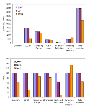
Figure 4.4 Emission of SO2 (top) and relative change of SO2 (bottom) for 2007, 2011 and 2020. Includes both land-based and marine emissions. The columns North and Baltic Sea represent the ship emissions for these two marine waters.
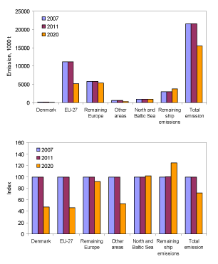
Figure 4.5 Emission of NOX (top) and relative change of NOX (bottom) for 2007, 2011 and 2020. The columns North and Baltic Sea represent the ship emissions for these two marine waters.
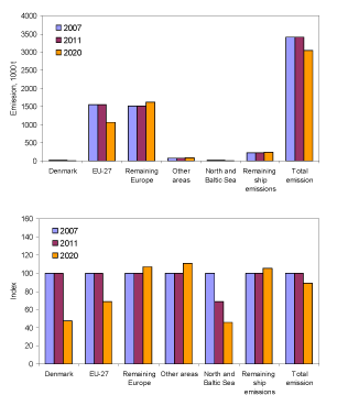
Figure 4.6 Emission of primary PM2.5 (top) and relative change of primary PM2.5 (bottom) for 2007, 2011 and 2020. The columns North and Baltic Sea represent the ship emissions for these two marine waters.
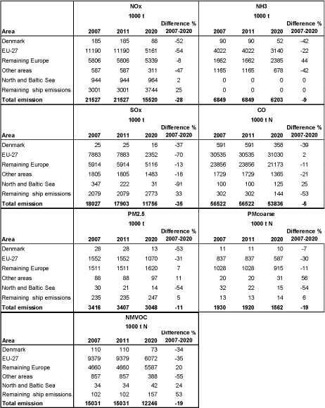
Table 4.1 Total emissions of NOX, NH3, SO2, CO, PM2.5, PMc0arse (PM10-PM2.5) and NMVOC (non methane volatile organic compounds). The columns North and Baltic Sea represent the ship emissions for these two marine waters
4.5 Results: Concentration levels
Figure 4.7 to Figure 4.10 show maps with results of the model calculations for concentration levels of SO2, NO2, primary PM2.5 and mPM2.5 (defined in section 4.2), using the three different ship emission inventories (EMEP-ref, AIS-sp and AIS-2007). It is clearly seen that there are major differences between the results using the three different inventories, both with respect to spatial distribution and the concentration levels.
In the following subsections, characteristics and differences between the three sets of results will be discussed. Readers who are mainly interested in the most accurate results should focus on results based on AIS-2007.
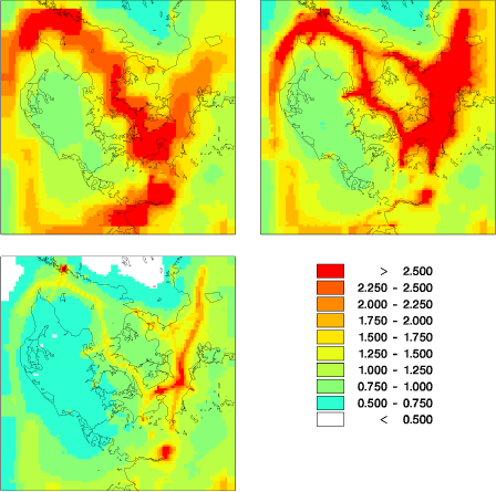
Figure 4.7 Model results for SO2 concentration levels using EMEP-ref (upper left), AIS-sp (upper right), and AIS-2007 (lower left) in units of µg/m³.
4.5.1 Spatial resolution
The major differences between the spatial distribution of the ship emissions are clearly reflected in the concentration maps for concentrations of SO2 and NO2 (Figure 4.7 and Figure 4.8). For primary PM2.5 and mPM2.5 the differences are less evident.
The reason for the large differences in the spatial distribution was described in depth in Chapter 3. Briefly, the original EMEP-ref emission inventory was based on information about which ports the ships were sailing from and to, while there was no information on the actual sailing routes. Erroneously a too large fraction of the ships was assumed to pass through the Great Belt compared to the Øresund. The AIS-sp and AIS-2007 inventory have been based on information on the actual sailing routes (Chapter 2 and Chapter 3). These two inventories give therefore a much more accurate representation of the spatial distribution of the emissions, and the results from use of these emission inventories are therefore also more accurate.
Another interesting result is the effect of the increase in spatial resolution from 50 km x 50 km (EMEP-ref) to 6 km x 6 km (AIS-sp and AIS-2007). In the results from the model calculations using EMEP-ref the large grid cells are clearly apparent (Figure 4.7 and Figure 4.8). Moreover, for SO2 concentrations it can be seen that the grid cells containing emissions from ships are actually covering land areas, leading to a significant overestimation of the air pollution with SO2 in these areas (Figure 4.7). In the results for SO2 concentrations based on AIS-sp and AIS-2007 the ship routes appear more distinct, in agreement with the fact that the majority of the ship traffic is confined to quite narrow ship routes through the Danish marine waters. Similar improvements also apply for NO2 and primary PM2.5.
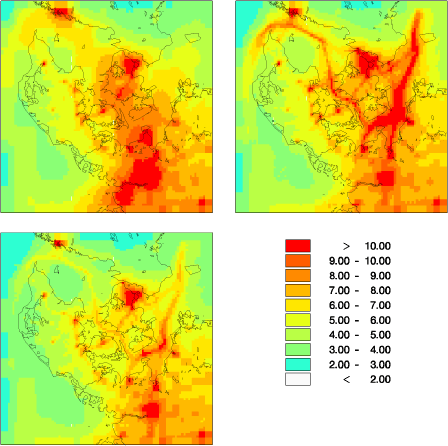
Figure 4.8 Model results for NO2 concentration levels using EMEP-ref (upper left), AIS-sp (upper right) and AIS-2007 (lower left) in units of µg/m³.
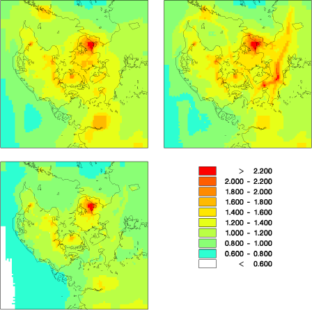
Figure 4.9 Model results for primary PM2.5 concentration levels using EMEP-ref (upper left), AIS-sp (upper right), and AIS-2007 (lower left) in units of µg/m³.
The spatial distribution for mPM2.5 (Figure 4.10) is completely different from SO2, NO2 and primary PM2.5 (Figure 4.7 to Figure 4.9). The reason for this is twofold. First, PM2.5 consists of particles with a long atmospheric lifetime. Hence, mPM2.5 is long range transported. Secondly, the ship emissions contribute only with less than 20% to mPM2.5 (cf. Section 4.6) while sources in the countries south of Denmark are responsible for the main part of mPM2.5 in Denmark. Altogether, this leads to a gradient with decreasing mPM2.5 going from South to North. This gradient dominates the spatial distribution of mPM2.5, and the sailing routes are only visible in Kattegat in AIS-sp.
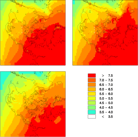
Figure 4.10 Model results for mPM2.5 concentration levels (only primary and secondary inorganic particles) using EMEP-ref (upper left), AIS-sp (upper right), and AIS-2007 (lower left) in units of µg/m³.
In general for all compounds, the concentration levels are more or less the same when comparing results where either EMEP-ref or AIS-sp is the underlying inventory, whereas concentrations are lower when AIS-2007 is used (Figure 4.7 - Figure 4.10). This is to be expected since the total emissions from ships in the Danish marine waters are set to the same values in EMEP-ref and AIS-sp, while the ship emissions are considerably lower in AIS-2007 (Figure 4.3).
As noted before, the lower emissions in AIS-2007 are caused by the fact that the inventory takes account of the SECA-regulations, combined with improvements in the inventory itself (e.g. more accurate sailing routes), and better assumptions behind calculations of the emissions (cf. Chapter 2).
4.5.2 SO2 concentration levels by region
Figure 4.11 and Table 4.2 give an overview of the average concentrations for SO2, NO2, primary PM2.5 and PM2.5 (only primary and secondary inorganic particles) for the Danish regions and for Denmark using the three different emission inventories. Thus, it summarises information from the maps of the previous section.
For SO2 there are large differences between the average concentrations for the different regions. This is because ship emissions are a major source of SO2 in Denmark (see section 4.6) and because of the uneven spatial distribution of the ship traffic. This leads to high emissions of SO2 in the waters around Zeeland and close to Copenhagen. In addition the land-based emissions of SO2 are largest in Copenhagen and Zeeland. This leads to the highest concentrations in Copenhagen and Zeeland and the lowest concentrations in the Middle Jutland. EMEP-ref and AIS-sp resemble each other in respect to region-wise concentration levels. The lower ship emissions in AIS-2007 result in a reduction in the average modelled SO2 concentrations, compared to the results based on the original ship emissions from EMEP (EMEP-ref) of 36-51%; for Denmark in average the reduction is 44%. The reductions in the concentrations are nearly as high as the 64% reduction of the ship emissions from EMEP-ref to AIS-2007.
4.5.3 NO2 concentration levels by region
For NO2 a very similar pattern to that of SO2 can be seen with the highest concentrations in Copenhagen and Zeeland and the lowest concentrations in North and Middle Jutland. This complies with the location of the main NO2 sources that are land-based combustion sources, while ship traffic contributes with about 1/5 to the concentrations of NO2 (cf. section 4.6). The change from EMEP-ref to AIS-2007 leads to a reduction in the modelled NO2 concentration in the different regions of 7-20%; for Denmark in average 13%. This is about a third of the 39% reduction in the ship emissions from EMEP-ref to AIS-2007 and agrees well with the fact that about 1/5 of the NO2 concentration originates from ship traffic.
4.5.4 PM2.5 concentration levels by region
For primary PM2.5 and mPM2.5 there are only minor differences between the regions. This is because of the long atmospheric lifetime of PM2.5 that leads to more evenly distributed concentrations of PM2.5 and mPM2.5, as compared to SO2 and NO2. Moreover, only a minor part (about 10-20%) of mPM2.5 originates from ship emissions (cf. section 4.6) and hence there is only a 9-16% change in concentrations of mPM2.5 for the various regions when EMEP-ref is compared with AIS-2007; for Denmark in average the reduction is 10%. This is despite the fact that the emissions of primary PM2.5 from ships are reduced by 72% going from EMEP-ref to AIS-2007.
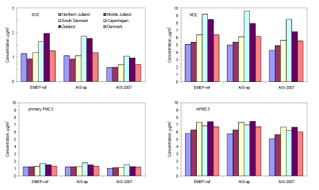
Figure 4.11 Model calculated average concentrations for SO2, NO2, primary PM2.5 and mPM2.5 (only primary and secondary inorganic particles) for the Danish regions and Denmark using EMEP-ref, AIS-sp, AIS-2007. Note that the values for Copenhagen refer for the entire Copenhagen region and therefore differ from the urban background in the centre of Copenhagen.
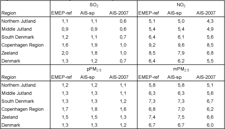
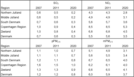
Table 4.2 Model calculated average concentrations in µg/m³ for SO2, NO2, primary PM2.5 and mPM2.5 (only primary and secondary inorganic particles) for the Danish regions and Denmark using EMEP-ref , AIS-sp, AIS-2007.
4.6 Contribution from ships
As explained in section 4.4 the contribution to air pollution from ships can be estimated by comparing results of two model calculations: one with ship emissions, and the other with reduced ship emissions. Figure 4.12 shows results for the relative contribution from ships according to the three inventories under discussion. Table 4.3 contains the corresponding values.
For all the compounds it can clearly be seen that the difference between EMEP-ref and AIS-sp is small, since the improved spatial distribution for the ship emissions does not lead to significant changes for the concentration levels in Denmark in average. However, there is a large difference between results based on EMEP-ref and on AIS-2007 due to the lower ship emissions in AIS-2007.
As explained before, AIS-2007 is considered as the most reliable inventory. Based on AIS-2007 it is seen that the largest contribution from ship emissions is for SO2, where 37% of the average concentration is due to ship emissions. For the other compounds the contribution to concentration levels from ship emissions lies in the range from 18-23% except for primary PM2.5 where the contribution is as small as 6%.
For mPM2.5 as an average over Denmark, the contribution from ships is estimated to be around 18% based on AIS-2007. This result can not be interpreted to say that ship pollution is responsible for 18% of the particle pollution in Danish ambient air, because mPM2.5 is only a part of the total PM2.5 found in the atmosphere. Some further considerations along this line can be found in section 4.9. It can be noted that based on the previous inventories the relative contribution from ships to mPM2.5 was 25%
The changes in the ship emissions also have an impact on ammonia (NH3) and particulate ammonium (NH4+) although they are not emitted from ships. When the level of SO2 is reduced NH3 increases and NH4+ decreases. This is due to the large changes in the ship emissions of SO2 and the chemical reactions between sulphur compounds and ammonia and ammonium:
SO2 –> –> –> H2SO4
H2SO4 + NH3 –> NH4HSO4
NH4HSO4 + NH3 –> (NH4)2SO4
The large decrease in the concentrations of SO2 leads to formation of less sulphuric acid (H2SO4) which again slows down the reaction between H2SO4 and NH3, leading to formation of particulate NH4+ in form of ammonium bisulphate (NH4HSO4) and ammonium sulphate ((NH4)2SO4). Hence the reductions in the relative contribution from ship traffic to SO2 due to change from EMEP-ref to AIS-2007 leads to a minor increase in NH3 and a decrease in NH4+.
Table 4.3 Corresponds to Figure 4.12. Relative contribution from ship emissions to the average concentrations of selected air pollutants in Denmark in 2007 with three different emission inventories.
| SO2 | SO4²- | NO2 | SNO3 | NH3 | NH4 | pPM2.5 | mPM2.5 | |
| EMEP-ref | 68% | 33% | 32% | 24% | -10% | 25% | 18% | 25% |
| AIS-sp | 66% | 36% | 30% | 26% | -9% | 25% | 16% | 25% |
| AIS-2007 | 37% | 21% | 21% | 23% | -6% | 18% | 6% | 18% |
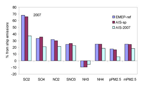
Figure 4.12 Relative contribution from ship emissions to the average concentrations of selected air pollutants in Denmark in 2007 with the three different emission inventories EMEP-ref, AIS-sp, and AIS-2007. SO4 is SO4²-. pPM2.5 is primary PM2.5. mPM2.5 is the model calculated PM2.5. SNO3 is the sum of nitric acid (HNO3) and particulate nitrate. The negative values for NH3 occur because reductions in SO2 from ships lead to an increase in NH3. This is a consequence of the way the contribution from ships is calculated
4.7 Comparison with measurements
A comparison between model calculations and measurements has been carried out in order to validate the results of the model calculations using the new ship emission inventories. The results from this comparison can be seen in Figure 4.13 for some of the main compound of interest in relation to ship emissions.
For SO2 the change to the AIS-2007 emission inventory for ships has lead to major reductions in concentration values modelled for the Danish monitoring stations, thereby causing a significant improvement of the model calculations. The improvement is most dramatic for the two coastal monitoring stations Anholt and Keldsnor where the change from EMEP-ref to AIS-2007 has resulted in a reduction in calculated SO2 concentration by a factor of 3 and 2, respectively. However, also for the inland monitoring station Tange there is a significant reduction by a factor of 1.5. The results from use of the new ship emission inventory (AIS-2007) are in very good agreement with the measurements, while use of the original inventory EMEP-ref resulted in significant overestimation of SO2.
For NO2, particulate SO4²- and secondary inorganic particles there are only minor changes between the results obtained from the use of the three different emission inventories. In general, use of AIS-2007 has resulted in a reduction of the concentrations of only about 10-36% compared to EMEP-ref.
For NO2, particulate SO4²- and secondary inorganic particles, EMEP-ref is in general in better agreement with the measurements than AIS-2007. However, despite this AIS-2007 is still in good agreement with the measurement results. For NO2 the differences between model calculations using AIS-2007 and measurements are 7-32%, for particulate SO4²- the differences are 24-34% and for secondary inorganic particles the differences are 23-31%.
The minor worsening for NO2, particulate SO4²- and secondary inorganic particles is believed to be secondary to the major improvements for SO2. It is therefore concluded that the newly developed emission inventory AIS-2007 is a significant improvement compared to the original emission inventory from EMEP (EMEP-ref). Use of the original ship emissions from EMEP (EMEP-ref) leads therefore to model results with too high concentrations of SO2 for Denmark.
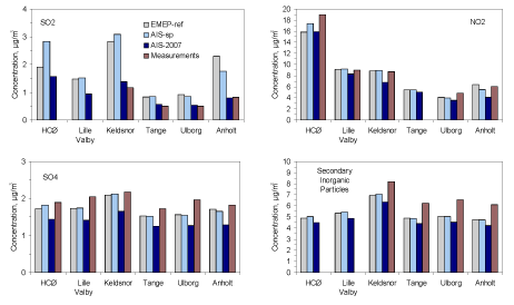
Figure 4.13 Comparison between results from model calculations and measurements for the concentrations of SO2, NO2, particulate SO4²- and secondary inorganic particles in 2007 at selected Danish monitoring stations. Model calculations are carried out using the three different emission inventories EMEP-ref, AIS-sp and AIS-2007. SO2 and secondary inorganic particles are not measured at HCØ and Lille Valby
4.8 Scenarios for 2011 and 2020
The results of the model calculations for 2007 and the scenario calculations for 2011 and 2020 are shown in Figure 4.13 to Figure 4.17 for SO2, NO2, primary PM2.5 and PM2.5, respectively. All three sets of model calculations are carried out using meteorology from year 2007, so that the only difference between the years is the difference in the emissions. The emission inventories for the ship emissions are all based on AIS-2007 that has been scaled to 2011 and 2020 based on the expected changes in ship traffic intensity and effect of the IMO regulations of the emissions from ships (see Chapter 3). The basis for the scenarios for the emissions from land-based sources and aviation in 2011 and 2020 is explained in Chapter 1.3.
4.8.1 SO2 concentration levels - future scenarios
For SO2 concentrations, the scenario calculations show that there will be a decrease of about 13% between 2007 and 2011. The SO2 concentration will continue to decrease up to 2020, so that the overall change from 2007 to 2020 is about 62% in terms of concentrations. The decrease is approximately the same for all the Danish regions (Figure 4.18). From 2007 to 2020 a 90 % reduction is expected for the ship emissions of SO2 in both the North Sea and Baltic Sea, and it is evident that this large reduction contributes substantially to the reduction in the SO2 level. This can also be seen directly from Figure 4.14, where the distinct SO2 signal from the sailing routes in 2007 disappears in 2020. However, from 2007 to 2020 a 70% emission reduction is expected for the land-based sources of SO2 in EU-27, and this reduction will also contribute substantially to the reduction in SO2. In 2020 the average Danish SO2 concentration is expected to be only 0.3 µg/m³, corresponding to only about 6% of the average concentration measured in 1990 at the Danish monitoring stations in the Danish background monitoring programme (Ellermann et. al., 2009). Moreover, the average concentration is as little as 1.5% of the EU limit value for protection of vegetation, and the concentrations will also be far below the limit values for protection of human health (EU directive 2008/50/EF).
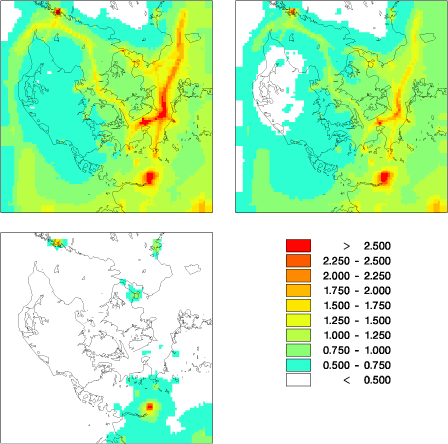
Figure 4.14 Model results for SO2 using AIS for 2007 (upper left), 2011 (upper right) and 2020 (lower left) in units of µg/m³.
4.8.2 NO2 concentration levels - future scenarios
The development for NO2 is somewhat different from SO2 since the average ship emissions for NOx in the North and Baltic Sea is expected to remain essentially unchanged from 2007 to 2020. The change in the average Danish NO2 concentrations is therefore smaller than for SO2. From 2007 to 2011 no change is calculated, but from 2007 to 2020 a reduction of 36% is expected for the average concentration of NO2 for all the Danish regions (Figure 4.18). This reduction is mainly driven by a 50% reduction in the land-based NO2 sources in Denmark and in the remaining EU-27. That it is the land-based sources that causes the reductions in NO2 and not the ship traffic, can also be seen from Figure 4.15. The Danish highways are clearly seen in 2007 but disappear in 2020, while the sailing routes are visible both in 2007 and 2020.
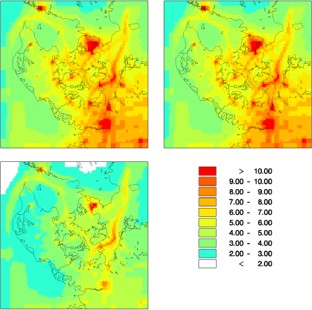
Figure 4.15 Model results for NO2 using AIS for 2007 (upper left), 2011 (upper right) and 2020 (lower left) in units of µg/m³.
4.8.3 PM2.5 concentration levels - future scenarios
For primary PM2.5 a 2% reduction in concentrations is expected from 2007 to 2011 solely due to a 30% reduction in ship emissions of primary PM2.5 in the North and Baltic Sea. During the period from 2007 to 2020 a 34% reduction of primary PM2.5 is expected for all the Danish regions (Figure 4.18). The reductions in primary PM2.5 are mainly caused by 50% reductions in the ship emissions from the North and Baltic Sea and from land-based sources in Denmark, as well as a 30% reduction in emissions from the remaining EU-27.
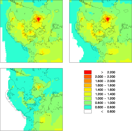
Figure 4.16 Model results for primary PM2.5 using AIS for 2007 (upper left), 2011 (upper right) and 2020 (lower left) in units of µg/m³.
For mPM2.5 (defined in section 4.2) only a 3% reduction in concentration level is expected from 2007 to 2011 (Figure 4.17 and Figure 4.18). This is due to reductions in ship emissions of primary PM2.5 and SO2 (Table 4.1). SO2 leads to formation of particulate sulphate that is one of the components of secondary inorganic particles. During the period from 2007 to 2020 a 39% reduction of mPM2.5 is expected for all the Danish regions (Figure 4.18). The reductions in mPM2.5 are mainly caused by reductions in the ship emissions from the North and Baltic Sea, land-based sources in Denmark and reductions in land-based emissions from the remaining EU-27.
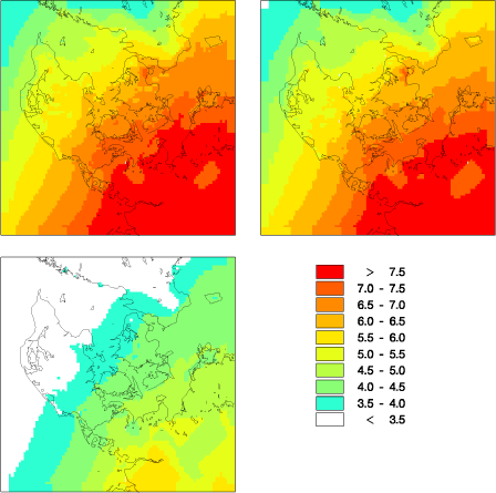
Figure 4.17 Model results for mPM2.5 (only primary and secondary inorganic particles) using AIS for 2007 (upper left), 2011 (upper right) and 2020 (lower left) in units of µg/m³
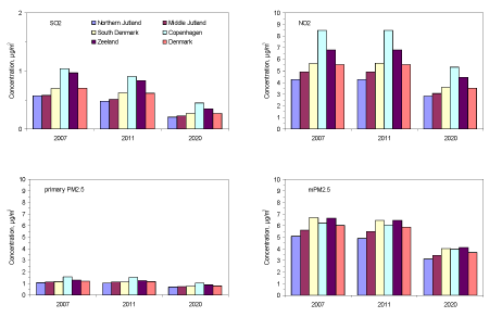
Figure 4.18 Average concentrations for the Danish regions for SO2, NO2, primary PM2.5 and mPM2.5 (only primary and secondary inorganic particles) using AIS for 2007, 2011 and 2020. Note that the values for Copenhagen refer to the entire Copenhagen region and therefore differ from the urban background in the centre of Copenhagen.
Table 4.4 Average concentrations for the Danish regions in µg/m³ for SO2, NO2, primary PM2.5 and mPM2.5 (only primary and secondary inorganic particles) using AIS for 2007, 2011 and 2020.
4.8.4 Contribution from ships according to the scenarios
As explained in section 4.4 the contribution to air pollution from ships can be estimated by comparing results of two model calculations: one with ship emissions, and the other with reduced ship emissions.
Figure 4.19 and Table 4.4 shows the average annual concentrations for Denmark calculated for 2007 and as expected for 2020. For the sulphur compounds the main change from 2007 to 2020 is a decrease due to the regulations of the ship emissions. For NO2 and the sum of particulate nitrate and nitric acid there are also large reductions. However, these reductions are due to expected regulations of the land based sources. Also for the particles (primary PM2.5 and mPM2.5) the reductions are mainly due to reductions of land-based sources. However, for the particles minor reductions are also seen for the ship emissions.
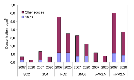
Figure 4.19 Average annual concentrations for Denmark for 2007 and 2020 divided in contribution from ships and other sources. SO4 is SO4²-. pPM2.5 is primary PM2.5 and SNO3 is the sum of nitric acid (HNO3) and particulate nitrate. Finally mPM2.5 is the part of PM2.5 included in the model.
Table 4.5 Average annual concentrations in µg/m³ for Denmark for 2007 and 2020 divided in contribution from ships and other sources. SO4 is SO4²-. pPM2.5 is primary PM2.5 and SNO3 is the sum of nitric acid (HNO3) and particulate nitrate. mPM2.5 is the part of PM2.5 included in the model.
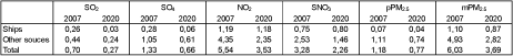
Figure 4.20 shows the development in the relative contribution to air pollution originating from ship emissions. Large reductions in concentration levels are expected for SO2 (37%?10%) and SO4²- (21%?9%), when going from 2007 to 2020. This is due to the 91% reduction of the emissions from ships in the North and Baltic Sea. This reduction is larger than the reductions in other sources (Table 4.1) and hence there is a decrease in the relative amount of SO2 and SO4²- originating from ship traffic.
For NO2 (21%?34%), HNO3+NO3 (23%?35%), and PM2.5(18%?23%) the relative amount originating from ship emissions is expected to increase in the period from 2007 to 2020 (Figure 4.20). This is because the land-based sources are reduced more than the ship emissions (Table 4.1). For primary PM2.5 (6%?5%), there is practically no change in the relative amount originating from ship emissions because land-based sources in Denmark and EU-27 and ship emissions are reduced with approximately the same fraction (Table 4.1).
Figure 4.20 Relative contribution from ship emissions to the average concentrations of selected air pollutants in Denmark in 2007, 2011 and 2020 based on AIS. SO4 is SO4²-. pPM2.5 is primary PM2.5 and SNO3 is the sum of nitric acid (HNO3) and particulate nitrate. mPM2.5 is the part of PM2.5 included in the model.
4.9 Concentration levels in Copenhagen
The influence of ship traffic to the general level of air pollution in the Copenhagen area has also been investigated within the current project. The reason for this is that there are problems with too high air pollution levels of NO2 and PM2.5 in the Copenhagen area and that the intensity in the ship traffic in Øresund is high. Figure 4.21 shows the model calculated concentrations for SO2, NO2 and mPM2.5 at the urban background station at the H.C. Ørsteds Institute in Copenhagen and at the rural background station Lille Valby about 30 km west of Copenhagen.
For SO2 concentration a significant reduction can be seen when going from 2007 to 2020 at both stations. It is also clearly seen that the amount of SO2 coming from ship traffic is significant in 2007 and that the IMO regulations of the emissions of SO2 from ships is expected to reduce the contribution from ships to a very low value.
For NO2 there is similarly a marked decrease in the NO2 concentration at both stations from 2007 to 2020. However, the absolute amount of NO2 coming from ships remains constant, whereas the reductions from the land-based sources are responsible for the reduction in the NO2 concentration. The contribution from ship traffic to the urban background concentration of NO2 is therefore expected to change from 12% in 2007 to 21% in 2020. In a longer time perspective the contribution from ships can be expected to decrease, at least in absolute terms, because of strict requirements to NOX emissions implemented for new ships from 2016.
It is interesting to note that for the urban background the NO2 concentration is expected to decrease from about 16 μg/m³ in 2007 to about 9 μg/m³in 2020. This reduction in urban background NO2 will reduce the problems with exceedances of the EU limit values for NO2 in Copenhagen.
For mPM2.5 the situation is much the same as for NO2. A considerable change in concentrations takes place from 2007 to 2020, but there is only a barely visible change in the amount of mPM2.5 coming from ship emissions. Both values are small: 0.9 μg/m³ in 2007 and 0.7 μg/m³ in 2020. It should be recalled that the concentration values represented in Figure 4.21 are for the model calculated PM2.5 - mPM2.5 - which only includes primary PM2.5 and secondary inorganic particles, but not secondary organic particles. It is therefore interesting to compare with measurements of ambient PM2.5.
In 2007 the only measurements of PM2.5 were carried out at the street station at H.C. Andersens Boulevard in Copenhagen. Here the annual average concentration of PM2.5 was measured to 23 µg/m³ (Kemp et al., 2008).
The amount of primary PM2.5 and secondary inorganic particles originating from ships will to a good approximation be the same in urban background (HCØ) and at street level (H.C. Andersens Boulevard). According to the model calculations the ship contribution to this sum is approximately 0.9 μg/m³. Thus, the relative contribution from ships to pollution with PM2.5 in a busy street in Copenhagen - H.C. Andersens Boulevard in 2007 - can be estimated to 4% of total PM2.5.
In the urban background the relative contribution from ships is larger. The concentration of PM2.5 in urban background in Copenhagen (HCØ) was not measured until 2008. Here the concentration was measured to 13 µg/m³ (Kemp et al., 2009). Based on this it can be estimated that the contribution from ships to the urban background concentration of (total) PM2.5 was around 7%. Comparison with other measurements indicates that the PM2.5 value measured in 2008 may have been low compared to 2007. Use of the measured value for 2008 may therefore lead to an overestimation of the contribution for ship traffic to PM2.5. However, this does not change the conclusion that the impact of ship traffic on PM2.5 levels in Copenhagen is low.
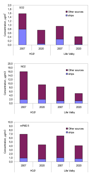
Figure 4.21 Development in the concentrations of SO2, NO2 and model calculated mPM2.5 at the urban background station at the H.C. Ørsteds Institute (HCØ) and at the rural background station Lille Valby.
[6] European Monitoring and Evaluation Programme. Full name: Co-operative Programme for Monitoring and Evaluation of the Long-Range Transmission of Air Pollutants in Europe.
Version 1.0 October 2009, © Danish Environmental Protection Agency