Ship emissions and air pollution in Denmark
3 Ship emission inventories for air pollution modelling
- 3.1 Introduction
- 3.2 "EMEP-ref" inventory
- 3.3 "AIS-2007" and "EMEP-2007" inventories
- 3.4 "AIS-sp" inventory
- 3.5 "AIS-2011" inventory
- 3.6 "AIS-2020" inventory
- 3.7 Summary of differences
3.1 Introduction
The previous chapter described how AIS-based inventories for ship emissions have been established. However, these data represent emissions for the AIS inventory area only (Figure 1.1). In order to apply the inventories in an air pollution model it is necessary to combine them with emission data covering a much larger geographical data.
The present chapter describes how the AIS-based data for ship emissions are combined with other ship emission data that cover a greater area. Some characteristics and differences between different inventories are also discussed. The chapter is entirely focussed on emissions from ships. Emissions from land-based sources are discussed in the subsequent chapter on air pollution modelling.
The following six emission inventories will be described and discussed:
EMEP-ref: Reference emission inventory based on the original ship emissions retrieved from the EMEP[5] database for 2006 with a spatial resolution of 50 km x 50 km (EMEP, 2008). Refers to the situation before SECA requirements for sulphur came into action. The EMEP inventory is based on an assumed sulphur content in residual oil of 2.7 % for several sea areas, including the North Sea and the Baltic Sea, following Cofala et al. (2007).
EMEP-2007: Emission inventory based on the above, but adjusted in order to represent conditions after the introduction of SECA. Emissions of sulphur and PM have been scaled down to reflect that introduction of SECA meant a reduction of sulphur content from 2.7 % to 1.5 %. No model runs have been performed for this inventory within the current project.
AIS-2007: Ship emissions based on AIS. Emissions for ships in SECA areas outside of the AIS inventory area have been scaled down to reflect that introduction of SECA meant a reduction of sulphur content from 2.7 % to 1.5 %. It has been assumed that the SECA regulations have been effective throughout the entire year of 2007.
AISsp-2007: Special version of the ship emissions based on AIS. This is a pre-SECA scenario. For the Danish marine waters AIS-based ship emissions are scaled up to the same total emission as those used in "EMEP-ref". The inventory is used to illustrate the effect of the improved spatial resolution of the ship emissions.
AIS-2011: Ship emission as AIS-2007, but projected to year 2011 based on the IMO-regulations and expectations on the development in the amount of ship traffic from 2007 to 2011. (All other emission sources are as for year 2007).
AIS-2020: Ship emission as AIS-2007, but projected to year 2020 based on the IMO-regulations, the assumption that the area considered is appointed a NOx Emission Control Area, and expectations on the development in ship traffic from 2007 to 2020. (All other emission sources have been projected to 2020 mainly based on the proposal for a new EU-directive for national emission ceilings in year 2020 - see Chapter 4).
The subsequent sections describe the inventories in more detail. They are used as basis for calculations of concentration levels, as described later in Chapter 4. Section 3.7 summarises differences between the inventories.
3.2 "EMEP-ref" inventory
In recent years, regional air pollution modelling work at NERI has been based on emission inventories where the information concerning ship emissions was based on a combination of two inventories: For a global coverage, the global ships emissions inventories of SO2, NOx, VOC, CO and PM by Corbett (see Wang et all, 2007) on a 0.1ox0.1ogrid was used. For the area around Europe the global ship emissions were replaced by emissions as estimated by EMEP for the year 2006 (latest reporting year; Cofala et al, 2007).
Figure 3.1 shows the emissions from ships based on these previous emissions inventories for the year 2006 for SO2, NOx, CO and PM2.5. The gridded EMEP emissions for the ships traffic (see Cofala et al., 2007) are based on an inventory of the emissions of marine activities that has been developed by ENTEC. This inventory is based on earlier estimates of emissions from ship movements between ports of the European Community that were compiled by Entec in 2002 and 2005 (see Whall et al, 2002, Entec 2005a-d). Emissions were estimated on the basis of vessel movement data and the underlying vessel emission factors as specified in Entec (2005a-d). The basis for this was four months of statistics obtained from Lloyds Marine Intelligence Unit (LMIU), which contains information about movements world-wide of ships, e.g. ships id, vessel type, engine type, Arrival/Departure Port/Place, Arrival/Departure Dates, etc. Based on the information on departure/arrival ports it is assumed that a vessel takes the shortest straight line route between two ports. When land prohibits this, the vessel takes the shortest route around the land towards the destination port. This procedure is used to establish the spatial distribution of emissions. Furthermore it is assumed that in open sea the engine load percentage is 80% of the maximum continuous rating (MCR), while in ports and during manoeuvring it is 20%. Concerning sulphur emissions, it is assumed that sulphur contents in residual oil is 2.7 percent (Cofala et al., 2007), and in marine distillates 0.2 percent.
The resolution of the air pollution transport model (DEHM) for the area around Denmark is 5.6 km. However, as seen on Figure 3.1 the resolution of the EMEP ship emissions is much cruder: 50 km. This means that over land close to the water there are ships emissions, which may result in an unrealistic contribution from ships emissions in these areas, as e.g. in Copenhagen and Aarhus. As also seen on the figure, the resulting ship emissions for the old emissions inventory assumes that most of the international ships traffic between the Baltic Sea and the North Sea passes through the Great Belt, probably because of the assumptions that are used to estimate the route for traffic between ports in the Baltic Sea and outside of it. The inventories shown in Figure 3.1 and the model runs based on these are called EMEP-ref.
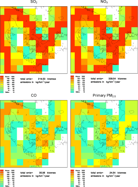
Figure 3.1 The original EMEP ship emissions for the year 2006 (called EMEP-ref). These are pre-SECA data. Upper left SO2 emissions, upper right NOx emissions, lower left CO emissions and lower right pm2.5 emissions. Note that although the labels say 2007 the inventory year is 2006 (pre-SECA).
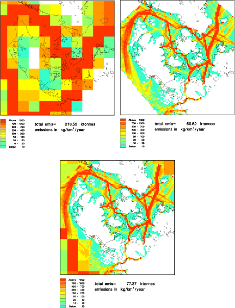
Figure 3.2 The EMEP-ref ship emissions of S02 (pre-SECA) are shown on the upper left, and the new AIS-based emissions of SO2 on the upper right. The lower figure shows how they are merged to form the post-SECA emission inventory called AIS-2007 as described in the text. The indicated totals represent the total for the area seen. They are not directly comparable to the totals given in the previous chapter.
3.3 "AIS-2007" and "EMEP-2007" inventories
Figure 3.2 illustrates how the emission inventories based on AIS data and the EMEP ship emissions are combined. The upper part of the figure shows the old SO2 EMEP ship emissions (the same as in Figure 3.1) and the new AIS-based emission inventory of SO2 based on the AIS data (corresponding to Figure 2.11), aggregated to 5.6 x 5.6 km resolution. These two inventories are merged to one single inventory. However, before merging them it should be taken into account that the EMEP-ref inventory represents data from before the SECA area became effective. EMEP-ref ship emissions are calculated with the assumption of a sulphur content of 2.7% in the residual oil. On the other hand, AIS emission data represent post-SECA conditions, where a sulphur content of 1.5% has been assumed.
The EMEP inventory can be adjusted for this by correcting the EMEP emissions of SO2 by a factor 0.563 and PM emissions by a factor 0.429. The corrected EMEP ship emissions are called EMEP-2007. Table 3.1 - Table 3.5 in section 3.7 summarise key values for the various emission inventories.
These two inventories - EMEP-2007 and the AIS-based - are merged to one single inventory by replacing the EMEP ship emissions with AIS emissions, where the AIS emissions cover an entire 50x50 km emissions grid or cover all ocean water. At the borders of the AIS area, where AIS emissions do not cover an entire grid cell, the AIS values and a residual value from EMEP are added. The residual is determined by an intelligent interpolation technique, which takes account of the EMEP emissions, the AIS emissions and the emissions in the neighbour grid cells of both EMEP and AIS emissions. The final result of this merging for the SO2 emissions is shown at bottom of Figure 3.2.
There are several interesting features about the new inventory. First, it has a much higher spatial resolution than EMEP-ref. There is not so much ship emission over land except in cities with large harbours. In the new inventory there is larger ship emissions in the Øresund compared to the EMEP inventories. Presumably this is because in the AIS data there are more ships passing through the Øresund as compared to the ENTEC data. This will be discussed further in section 3.7.
Another very important difference between the inventories is that total emissions are considerably lower according to the new inventory. Also this issue will be discussed in section 3.7.
Figure 3.3 shows the combined EMEP-2007 and AIS emission inventory for SO2, NOx, CO and PM2.5. This inventory is believed to be the most correct ship emission inventory for the year 2007 around Denmark. The inventory and the model runs based on it are called AIS-2007.
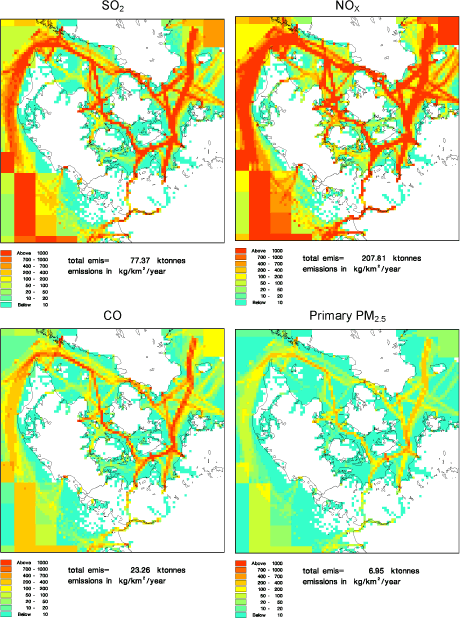
Figure 3.3 AIS-2007 inventory, representing post-SECA conditions. Formed by combing the AIS-based inventory with EMEP-2007 (a version of EMEP-ref where SO2 and pm2.5 emissions are scaled to reflect post-SECA conditions). Upper left SO2 emissions, upper right NOx emissions, lower left CO emissions and lower right pm2.5 emissions.
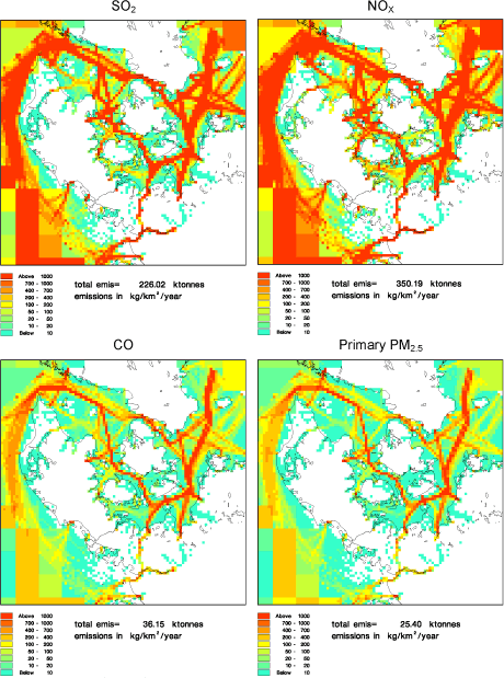
Figure 3.4 AIS-sp (special) inventory. The original EMEP ship emissions combined with AIS based emissions, which are scaled in order to have the total emissions as for the original EMEP ships emissions. The emission inventory is called AIS. Upper left SO2 emissions, upper right NOx emissions, lower left CO emissions and lower right pm2.5 emissions.
3.4 "AIS-sp" inventory
In order to investigate the differences caused by the finer resolution of the new emission inventories, as compared to the coarse EMEP inventory, a special inventory was established. The AIS emissions were scaled up in order to obtain the same total emission as the EMEP-ref ship emissions in Figure 3.1 (pre-SECA). This special inventory is shown in Figure 3.4 for four pollutants. The inventories and the model runs based on these are called AIS-sp (for special).
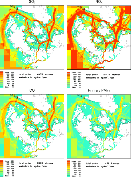
Figure 3.5 AIS-2011. The original EMEP ship emissions, where SO2 and pm2.5 emissions are scaled to the year 2011, combined with AIS based emissions for 2011. . Upper left SO2 emissions, upper right NOx emissions, lower left CO emissions and lower right pm2.5 emissions.
3.5 "AIS-2011" inventory
Figure 3.5 shows inventories for the year 2011. They are a combination of the AIS 2011 emission inventories and the EMEP-2007 inventories, where the EMEP SO2 emissions and PM emissions are multiplied with the ratio between emissions for 2011 and 2007 in the AIS inventories. For SO2 the ratio is 0.64 and for PM it is 0.69. In 2011 it is expected that emissions of SO2 and PM from ships will be about 30-35 % lower compared to the emissions in 2007. These inventories and the model runs based on these are called AIS-2011.
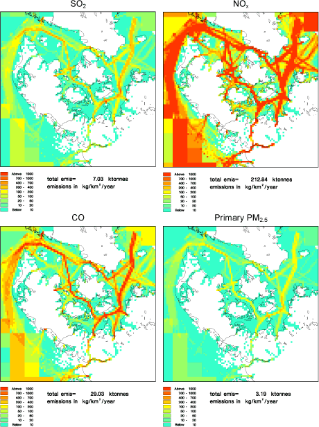
Figure 3.6 AIS-2020. The original EMEP ship emissions, where the emissions are scaled to the year 2020, combined with AIS based emissions for 2020. Upper left SO2 emissions, upper right NOx emissions, lower left CO emissions and lower right pm2.5 emissions.
3.6 "AIS-2020" inventory
Figure 3.6 shows inventories for the year 2020. They are a combination of the AIS 2020 emission inventories and the EMEP-2007 inventories, where all the EMEP emissions are multiplied with the ratio between 2020 and 2007 emissions in the AIS inventories. For SO2 the ratio is 0.09, for PM it is 0.46, for CO it is 1.25, for NOx it is 1.02, and for VOC 1.24. In 2020 it is expected that the SO2 emissions from ships will decrease by 91% compared to emissions in 2007, and PM emissions will decrease by more than 50%. The CO and VOC emissions will increase by 25% due to the expected increase in ship traffic, while the NOx will be nearly the same. These inventories and the model runs based on them are called AIS-2020.
3.7 Summary of differences
In Table 3.1 - Table 3.5 the emissions for the different marine waters around Denmark (the Baltic Sea West of Bornholm, Great Belt, Øresund and Kattegat) are summarized for the different emissions inventories used in the model calculations. Again the tables confirm that for the Øresund the new AIS emissions are higher than even the pre-SECA EMEP-ref inventory (with high sulphur content). If one compares the AIS-2007 emissions with the EMEP-2007 (both have the same sulphur content) one can see that the emissions for the Western Baltic Sea are nearly the same, whereas for the Great Belt and Kattegat the EMEP-2007 emissions are more than a factor of 2 higher; for the Øresund it is opposite. For the EMEP-ref inventory the total emissions in Great Belt are a factor of 11-12 higher than the total emissions in the Øresund, but for the AIS emissions it is only a factor of 2 higher, again indicating that the AIS data have more ship traffic through the Øresund relative to the Great Belt, compared to the data underlying the EMEP emissions.
When looking at the ENTEC report (Whall et al, 2002), which is the basis for the EMEP inventories, it seems that ENTEC has no ship movements through the Kiel Canal; instead, it assumes that these ships are taking a long route around Jutland to the North Sea through the Great Belt. In the AIS emission inventories there are emissions in the Kiel Canal (see Figure 3.3). This observed ship traffic through the Kiel-Canal will change the spatial distribution, so ship traffic is moved from the Great Belt and Kattegat to the Western Baltic Sea. This will also reduce the travel distance a lot, and therefore reduce fuel consumption and emissions in these areas. According to the official traffic statistic for Kiel-Canal, the total gross tonnage of the ships that passed through the Kiel-Canal from 2000 to 2007 has increased by 77% in the period (see http://www.kiel-canal.org/english.htm).
AIS-based emissions are generally lower than their EMEP counterpart, however with exceptions for some waters. One of the reasons for this difference is that EMEP always assumes that the engine load for the ships is 80% of the maximum in open sea, whereas for AIS-based emission inventories the engine load is estimated by using the actual speed of the ship.
The overall conclusion of the discussion above is that emissions based on the AIS data are expected to be better than the old EMEP inventory, because the AIS data have much more precise information of the different ships' location and speed compared to the crude assumptions made in the EMEP emission inventory. Furthermore, in Kattegat and Great Belt the AIS emissions are a factor of 2 smaller than the EMEP-2007 emissions, for the Western Baltic Sea they are very similar, and for the Øresund the AIS emissions are a factor 2 higher.
Table 3.1 SO2 emissions in kT SO2 for the different ocean waters and different inventories
| EMEP- ref |
EMEP- 2007 |
AIS- sp |
AIS- 2007 |
AIS- 2011 |
AIS- 2020 |
|
| Western Baltic Sea | 42.4 | 23.9 | 78.8 | 24.4 | 15.7 | 2.1 |
| Great Belt | 24.9 | 14.0 | 20.7 | 6.4 | 4.1 | 0.6 |
| Øresund | 2.3 | 1.3 | 9.0 | 2.8 | 1.8 | 0.3 |
| Kattegat | 41.0 | 23.0 | 35.5 | 11.2 | 7.2 | 1.0 |
| Area shown in Figure 3.2 etc. | 218 | 123 | 226 | 78 | 50 | 7 |
Table 3.2 NOx emissions in kT NO2 for the different ocean waters and different inventories
| EMEP- ref |
EMEP- 2007 |
AIS- sp |
AIS- 2007 |
AIS- 2011 |
AIS- 2020 |
|
| Western Baltic Sea | 67.2 | 67.2 | 110.3 | 58.5 | 58.7 | 59.2 |
| Great Belt | 39.1 | 39.1 | 34.3 | 18.2 | 18.1 | 18.2 |
| Øresund | 3.1 | 3.1 | 14.6 | 7.8 | 7.8 | 7.9 |
| Kattegat | 64.0 | 64.0 | 58.3 | 31.5 | 31.4 | 32.3 |
| Area shown in Figure 3.2 etc. | 340 | 340 | 350 | 208 | 208 | 213 |
Table 3.3 CO emissions in kT for the different ocean waters and different inventories CO
| EMEP- ref |
EMEP- 2007 |
AIS- sp |
AIS- 2007 |
AIS- 2011 |
AIS- 2020 |
|
| Western Baltic Sea | 6.8 | 6.8 | 12.3 | 7.3 | 7.3 | 8.8 |
| Great Belt | 4.0 | 4.0 | 3.3 | 1.9 | 1.9 | 2.4 |
| Øresund | 0.4 | 0.4 | 1.6 | 0.9 | 1.0 | 1.2 |
| Kattegat | 6.6 | 6.5 | 5.8 | 3.5 | 3.5 | 4.4 |
| Area shown in Figure 3.2 etc. | 35 | 35 | 36 | 23 | 23 | 29 |
Table 3.4 VOC emissions in kT for the different ocean waters and different inventories
| EMEP- ref |
EMEP- 2007 |
AIS- sp |
AIS- 2007 |
AIS- 2011 |
AIS- 2020 |
|
| Western Baltic Sea | 2.3 | 2.3 | 4.1 | 2.3 | 2.3 | 2.8 |
| Great Belt | 1.3 | 1.3 | 1.2 | 0.7 | 0.7 | 0.8 |
| Øresund | 0.1 | 0.1 | 0.5 | 0.3 | 0.3 | 0.4 |
| Kattegat | 2.2 | 2.2 | 2.0 | 1.1 | 1.1 | 1.4 |
Table 3.5 PM2.5 emissions in kT for the different ocean waters and different inventories
| EMEP- ref |
EMEP- 2007 |
AIS- sp |
AIS- 2007 |
AIS- 2011 |
AIS- 2020 |
|
| Western Baltic Sea | 4.8 | 2.0 | 8.8 | 2.2 | 1.5 | 1.0 |
| Great Belt | 2.8 | 1.2 | 2.4 | 0.6 | 0.4 | 0.3 |
| Øresund | 0.2 | 0.1 | 1.0 | 0.3 | 0.2 | 0.1 |
| Kattegat | 4.6 | 2.0 | 4.0 | 1.0 | 0.7 | 0.5 |
| Area shown in Figure 3.2 etc. | 24.5 | 10.5 | 25.4 | 6.9 | 4.8 | 3.2 |
[5] European Monitoring and Evaluation Programme. Full name: Co-operative Programme for Monitoring and Evaluation of the Long-Range Transmission of Air Pollutants in Europe.
Version 1.0 October 2009, © Danish Environmental Protection Agency