Establishment of a basis for administrative use of PestSurf
Annex 12
12 Comparison of risk assessment data produced by spray drift assessments, FOCUS SW and PestSurf
12.1 Chemical characteristics of the compound
| Compound: | Tribenuron methyl |
| Dose: | 15 g ai/ha |
| Spraying time: | 1. April |
| Crop: | Winter wheat |
Table 12.1. Overview of chemical properties of tribenuron-methyl and the parameters used in the simulations.
Tabel 12.1. Oversigt over tribenuron-methyl s kemiske egenskaber og parametrene brugt i simuleringerne.
| Chemical property | Condition | Recalculated values | |||
| Cas-no. | 101200-48-0 | ||||
| Molecular weight | 395.4 | ||||
| Form (acid, basic, neutral) | acid | ||||
| pKa | 4.7 | ||||
| Water solubility | 2.04 g/l | pH 7 | at 20°C | ||
| log Kow | 2.6 | at pH | 5 | KowA- | 0.0094 |
| log Kow | 0.78 | at pH | 7 | KowAH | 3.08 |
| log Kow | 0.3 | at pH | 9 | KowAH+ | |
| Vapor pressure, Pa | 5.3x10⁻⁸ | 25°C | 175 (Decomposition) | vapor pressure, Pa, 20°C | 1.25 × 10⁻⁸ |
| Henry’s law constant | 1.0 × 10⁻⁸ Pa m³ mol-1 | pH7 | Recalculated value, dimensionless | 4.11 × 10⁻¹² | |
| Sorption properties in soil | |||||
| Freundlich exp | 0.95 | ||||
| Koc, l/kg | 22.2 | ||||
| DT50 in soil, days | 9.01 | ||||
| DT50water | 23.5 days | PestSurf input | |||
| DT50sedment | None mentioned | ||||
| DT50water/sediment | 25.5 days | DT50, days | 25.5 | ||
| Sediment konc., mg/l | 80 (default in PestSurf) | ||||
| Hydrolysis | Very fast | at pH 5 | (acid) | 5.25 × 10⁻⁶ | |
| <1 day | at pH 7 | (neutral) | 19.9 | ||
| >200 | at pH 9 | (basic) | indef | ||
| Photolysis | |||||
| quantum yield | n.a. | ||||
| Spectrum | 201 nm (log ε = 4.57) 256 nm (log ε = 4.26) no maxima beyond 290 nm |
||||
| Other | stable | ||||
12.2 Concentration generated by spray
| Direct spray | FOCUS buffer zones | |||
| Ditch | Stream | Pond | ||
| µg l-1 | µg l-1 | µg l-1 | µg l-1 | |
| Tribenuron methyl | 5.0 | 0.138 | 0.093 | 0.041 |
12.3 Concentrations generated by FOCUS SW
12.3.1 D3- Ditch
| Tribenuron methyl | Ditch, D3 | |||||||
| Water | Sediment | |||||||
| Date | PEC | Date | TWAEC | Date | PEC | Date | TWAEC | |
| µg l-1 | µg l-1 | µg kg-1 | µg kg-1 | |||||
| Global max | 04-apr-92 | 0.095 | 05-apr-92 | 0.011 | ||||
| 1 d | 05-apr-92 | 0.042 | 05-apr-92 | 0.073 | 06-apr-92 | 0.007 | 05-apr-92 | 0.01 |
| 2 d | 06-apr-92 | 0.004 | 06-apr-92 | 0.046 | 07-apr-92 | 0.005 | 06-apr-92 | 0.009 |
| 4 d | 08-apr-92 | 0 | 08-apr-92 | 0.024 | 09-apr-92 | 0.004 | 08-apr-92 | 0.007 |
| 7 d | 11-apr-92 | 0 | 11-apr-92 | 0.013 | 12-apr-92 | 0.003 | 11-apr-92 | 0.005 |
12.3.2 D4 – Stream
| Tribenuron methyl | Stream, D4 | |||||||
| Water | Sediment | |||||||
| Date | PEC | Date | TWAEC | Date | PEC | Date | TWAEC | |
| µg l-1 | µg l-1 | µg kg-1 | µg kg-1 | |||||
| Global max | 18-apr-85 | 0.076 | 18-apr-85 | 0.002 | ||||
| 1 d | 19-apr-85 | 0 | 19-apr-85 | 0.005 | 19-apr-85 | 0 | 19-apr-85 | 0.001 |
| 2 d | 20-apr-85 | 0 | 19-apr-85 | 0.003 | 20-apr-85 | 0 | 20-apr-85 | 0.001 |
| 4 d | 22-apr-85 | 0 | 18-apr-85 | 0.001 | 22-apr-85 | 0 | 22-apr-85 | 0 |
| 7 d | 25-apr-85 | 0 | 18-apr-85 | 0.001 | 25-apr-85 | 0 | 25-apr-85 | 0 |
12.3.3 D4 - Pond
| Tribenuron methyl | Pond, D4 | |||||||
| Water | Sediment | |||||||
| Date | PEC | Date | TWAEC | Date | PEC | Date | TWAEC | |
| µg l-1 | µg l-1 | µg kg-1 | µg kg-1 | |||||
| Global max | 18-apr-85 | 0.003 | 16-maj-85 | 0.002 | ||||
| 1 d | 19-apr-85 | 0.003 | 19-apr-85 | 0.003 | 17-maj-85 | 0.002 | 17-maj-85 | 0.002 |
| 2 d | 20-apr-85 | 0.003 | 20-apr-85 | 0.003 | 18-maj-85 | 0.002 | 17-maj-85 | 0.002 |
| 4 d | 22-apr-85 | 0.003 | 22-apr-85 | 0.003 | 20-maj-85 | 0.002 | 18-maj-85 | 0.002 |
| 7 d | 25-apr-85 | 0.003 | 25-apr-85 | 0.003 | 23-maj-85 | 0.002 | 20-maj-85 | 0.002 |
12.3.4 Conclusion – FOCUS SW
The highest concentration is generated in the ditch (D3). It is caused by wind drift and the concentration becomes 0.095 µg/l. The same scenario shows the highest concentration in the sediment, 0.011 µg/l. For all scenarios, the concentrations are lower than what is generated by the simpler assessments, but for the ditch and stream-scenarios the difference between the simple drift calculation and the FOCUS SW-simulation is rather small.
12.4 PestSurf
12.4.1 Sandy Catchment, stream
The distribution of concentrations was assessed in several steps. First, the maximum concentrations at each calculation point were listed, and the dates for the occurrence of the maximum were assessed. The points, for which the maximum value also represents a local maximum were selected for further analysis. The relevant values are listed in Table 12.2.
Table 12.2. Maximum concentrations (ng/l) of tribenuron methyl simulated for each calculation point in the sandy catchment.
Tabel 12.2. Maximumkoncentrationer (ng/l) af tribenuron-methyl simuleret for hvert beregningspunkt i det sandede opland.
| TRIBENURON | Maximum | Max.Time | Local maxima |
| ODDERBAEK 0.00 | 7 | 01-04-2001 08:41 | |
| ODDERBAEK 56.00 | 8 | 01-04-2001 08:41 | |
| ODDERBAEK 112.00 | 10 | 01-04-2001 08:33 | |
| ODDERBAEK 192.00 | 33 | 01-04-2001 08:33 | |
| ODDERBAEK 272.00 | 63 | 01-04-2001 08:33 | |
| ODDERBAEK 278.00 | 66 | 01-04-2001 08:33 | |
| ODDERBAEK 282.00 | 68 | 01-04-2001 08:33 | |
| ODDERBAEK 298.50 | 75 | 01-04-2001 08:33 | |
| ODDERBAEK 315.00 | 85 | 01-04-2001 08:24 | |
| ODDERBAEK 317.50 | 87 | 01-04-2001 08:24 | |
| ODDERBAEK 320.00 | 89 | 01-04-2001 08:24 | |
| ODDERBAEK 410.00 | 125 | 01-04-2001 08:33 | |
| ODDERBAEK 500.00 | 132 | 01-04-2001 08:33 | |
| ODDERBAEK 513.00 | 137 | 01-04-2001 08:33 | |
| ODDERBAEK 521.00 | 141 | 01-04-2001 08:33 | |
| ODDERBAEK 622.00 | 177 | 01-04-2001 08:33 | |
| ODDERBAEK 723.00 | 198 | 01-04-2001 08:33 | |
| ODDERBAEK 733.00 | 204 | 01-04-2001 08:33 | |
| ODDERBAEK 742.00 | 209 | 01-04-2001 08:33 | |
| ODDERBAEK 789.50 | 228 | 01-04-2001 08:33 | |
| ODDERBAEK 837.00 | 243 | 01-04-2001 08:33 | |
| ODDERBAEK 848.00 | 249 | 01-04-2001 08:33 | |
| ODDERBAEK 863.00 | 259 | 01-04-2001 08:33 | |
| ODDERBAEK 956.00 | 297 | 01-04-2001 08:33 | |
| ODDERBAEK 1049.00 | 318 | 01-04-2001 08:33 | x |
| ODDERBAEK 1111.50 | 321 | 01-04-2001 08:33 | |
| ODDERBAEK 1174.00 | 300 | 01-04-2001 08:33 | |
| ODDERBAEK 1226.00 | 287 | 01-04-2001 08:33 | |
| ODDERBAEK 1278.00 | 275 | 01-04-2001 08:33 | |
| ODDERBAEK 1293.50 | 270 | 01-04-2001 08:33 | |
| ODDERBAEK 1310.00 | 261 | 01-04-2001 08:41 | |
| ODDERBAEK 1421.00 | 263 | 01-04-2001 08:33 | |
| ODDERBAEK 1532.00 | 237 | 01-04-2001 08:33 | |
| ODDERBAEK 1558.06 | 208 | 01-04-2001 08:33 | |
| ODDERBAEK 1584.12 | 189 | 01-04-2001 08:33 | |
| ODDERBAEK 1584.12 | 189 | 01-04-2001 08:33 | |
| ODDERBAEK 1621.06 | 187 | 01-04-2001 08:33 | |
| ODDERBAEK 1658.00 | 187 | 01-04-2001 08:33 | |
| ODDERBAEK 1698.50 | 191 | 01-04-2001 08:33 | |
| ODDERBAEK 1739.00 | 195 | 01-04-2001 08:33 | |
| ODDERBAEK 1801.50 | 197 | 01-04-2001 08:33 | x |
| ODDERBAEK 1864.00 | 173 | 01-04-2001 08:33 | |
| ODDERBAEK 1977.00 | 143 | 01-04-2000 09:18 | |
| ODDERBAEK 2090.00 | 138 | 01-04-2000 09:26 | |
| ODDERBAEK 2098.00 | 138 | 01-04-2000 09:26 | |
| ODDERBAEK 2105.00 | 138 | 01-04-2000 09:26 | |
| ODDERBAEK 2131.00 | 136 | 01-04-2000 09:26 | |
| ODDERBAEK 2157.00 | 133 | 01-04-2000 09:26 | |
| ODDERBAEK 2168.00 | 132 | 01-04-2000 09:35 | |
| ODDERBAEK 2179.00 | 132 | 01-04-2000 09:35 | |
| ODDERBAEK 2268.50 | 130 | 01-04-2000 09:35 | |
| ODDERBAEK 2358.00 | 125 | 01-04-2001 09:45 | |
| ODDERBAEK 2363.50 | 124 | 01-04-2001 09:45 | |
| ODDERBAEK 2372.00 | 124 | 01-04-2001 09:45 | |
| ODDERBAEK 2427.00 | 123 | 01-04-2001 09:45 | |
| ODDERBAEK 2482.00 | 120 | 01-04-2001 09:54 | |
| ODDERBAEK 2609.00 | 119 | 01-04-2001 09:54 | |
| ODDERBAEK 2736.00 | 114 | 01-04-2001 10:00 | |
| ODDERBAEK 2831.00 | 113 | 01-04-2001 10:00 | |
| ODDERBAEK 2926.00 | 107 | 01-04-2001 10:00 | |
| ODDERBAEK 2958.50 | 106 | 01-04-2001 10:00 | |
| ODDERBAEK 2991.00 | 105 | 07-04-1998 09:53 | |
| ODDERBAEK 3029.50 | 104 | 07-04-1998 10:00 | |
| ODDERBAEK 3068.00 | 101 | 07-04-1998 10:00 | |
| ODDERBAEK 3131.00 | 95 | 07-04-1998 10:00 | |
| ODDERBAEK 3194.00 | 87 | 01-04-2001 11:00 | |
| ODDERBAEK 3250.50 | 88 | 01-04-2001 11:00 | |
| ODDERBAEK 3307.00 | 87 | 01-04-2001 11:00 | |
| ODDERBAEK 3315.00 | 87 | 01-04-2001 11:00 | |
| ODDERBAEK 3323.00 | 87 | 01-04-2001 11:00 | |
| ODDERBAEK 3355.50 | 87 | 01-04-2001 11:00 | |
| ODDERBAEK 3388.00 | 86 | 01-04-2001 11:00 | |
| ODDERBAEK 3438.50 | 86 | 01-04-2001 11:00 | |
| ODDERBAEK 3489.00 | 90 | 01-04-2001 08:33 | |
| ODDERBAEK 3499.50 | 91 | 01-04-2001 08:33 | |
| ODDERBAEK 3510.00 | 92 | 01-04-2001 08:33 | |
| ODDERBAEK 3581.00 | 94 | 01-04-2001 08:33 | x |
| ODDERBAEK 3652.00 | 89 | 01-04-2001 08:33 | |
| ODDERBAEK 3707.00 | 85 | 01-04-2001 08:33 | |
| ODDERBAEK 3762.00 | 78 | 01-04-2001 08:33 | |
| ODDERBAEK 3790.00 | 71 | 01-04-2001 08:41 | |
| ODDERBAEK 3818.00 | 59 | 07-04-1998 08:41 | |
| ODDERBAEK 3818.00 | 59 | 07-04-1998 08:41 | |
| ODDERBAEK 3884.00 | 60 | 07-04-1998 08:41 | |
| ODDERBAEK 3950.00 | 58 | 07-04-1998 11:00 | |
| ODDERBAEK 3998.00 | 58 | 07-04-1998 11:00 | |
| ODDERBAEK 4046.00 | 57 | 07-04-1998 11:00 | |
| ODDERBAEK 4047.50 | 57 | 07-04-1998 11:00 | |
| ODDERBAEK 4049.00 | 57 | 07-04-1998 11:00 | |
| ODDERBAEK 4052.50 | 57 | 07-04-1998 11:00 | |
| ODDERBAEK 4056.00 | 57 | 07-04-1998 11:00 | |
| ODDERBAEK 4058.00 | 57 | 07-04-1998 11:00 | |
| ODDERBAEK 4060.00 | 57 | 07-04-1998 11:00 | |
| ODDERBAEK 4080.00 | 57 | 07-04-1998 11:00 | |
| ODDERBAEK 4100.00 | 56 | 07-04-1998 11:00 | |
| ODDERBAEK 4134.00 | 56 | 07-04-1998 11:00 | |
| ODDERBAEK 4168.00 | 56 | 07-04-1998 11:00 | |
| GISLUM_ENGE_AFLOEB 0.00 | 0 | 13-02-2000 00:00 | |
| GISLUM_ENGE_AFLOEB 50.00 | 0 | 12-02-2000 00:00 | |
| GISLUM_ENGE_AFLOEB 100.00 | 0 | 13-02-2000 00:00 | |
| GISLUM_ENGE_AFLOEB 150.00 | 0 | 12-02-2000 00:00 | |
| GISLUM_ENGE_AFLOEB 200.00 | 0 | 12-02-2000 00:00 | |
| GISLUM_ENGE_AFLOEB 250.00 | 0 | 12-02-2000 00:00 | |
| GISLUM_ENGE_AFLOEB 300.00 | 0 | 12-02-2000 00:00 | |
| GISLUM_ENGE_AFLOEB 340.00 | 0 | 12-02-2000 00:00 | |
| GISLUM_ENGE_AFLOEB 380.00 | 0 | 12-02-2000 00:00 | |
| GISLUM_ENGE_AFLOEB 430.00 | 0 | 12-02-2000 00:00 | |
| GISLUM_ENGE_AFLOEB 480.00 | 0 | 13-02-2000 00:00 | |
| GISLUM_ENGE_AFLOEB 530.00 | 0 | 13-02-2000 00:00 | |
| GISLUM_ENGE_AFLOEB 580.00 | 0 | 13-02-2000 00:00 | |
| GISLUM_ENGE_AFLOEB 630.00 | 0 | 13-02-2000 00:00 | |
| GISLUM_ENGE_AFLOEB 680.00 | 0 | 13-02-2000 00:00 | |
| GISLUM_ENGE_AFLOEB 730.00 | 0 | 13-02-2000 00:00 | |
| GISLUM_ENGE_AFLOEB 780.00 | 0 | 13-02-2000 00:00 | |
| GISLUM_ENGE_AFLOEB 830.00 | 0 | 13-02-2000 00:00 | |
| GISLUM_ENGE_AFLOEB 880.00 | 0 | 13-02-2000 00:00 | |
| GISLUM_ENGE_AFLOEB 915.00 | 0 | 12-02-2000 00:00 | |
| GISLUM_ENGE_AFLOEB 950.00 | 0 | 12-02-2000 00:00 | |
| GISLUM_ENGE_AFLOEB 985.00 | 0 | 12-02-2000 00:00 | |
| GISLUM_ENGE_AFLOEB 1020.00 | 0 | 12-02-2000 00:00 | |
| GISLUM_ENGE_AFLOEB 1045.00 | 0 | 12-02-2000 00:00 | |
| GISLUM_ENGE_AFLOEB 1070.00 | 0 | 12-02-2000 00:00 | |
| GISLUM_ENGE_AFLOEB 1110.00 | 0 | 12-02-2000 00:00 | |
| GISLUM_ENGE_AFLOEB 1150.00 | 0 | 12-02-2000 00:00 | |
| GISLUM_ENGE_AFLOEB 1190.00 | 0 | 12-02-2000 00:00 | |
| GISLUM_ENGE_AFLOEB 1230.00 | 0 | 02-04-2003 08:41 | |
| GISLUM_ENGE_AFLOEB 1271.00 | 0 | 02-04-2003 08:41 | |
| GISLUM_ENGE_AFLOEB 1312.00 | 0 | 02-04-2003 08:41 | |
| GISLUM_ENGE_AFLOEB 1422.00 | 2 | 07-04-1998 08:41 | |
| GISLUM_ENGE_AFLOEB 1532.00 | 59 | 07-04-1998 08:41 | |
| TILLOEB 0.00 | 178 | 01-04-2001 08:33 | |
| TILLOEB 20.16 | 184 | 01-04-2001 08:33 | |
| TILLOEB 40.31 | 189 | 01-04-2001 08:33 | x |
| global max | 321 |
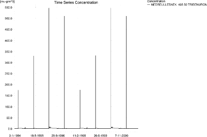
The pattern over time was the same for all calculation points. The peak values are generated by wind drift, see Figure 12.1.
Each of the events generated an almost identical pattern along the stream. Figure 12.2 to Figure 12.5 show the peak concentrations of tribenuron methyl moving through the sandy catchment after spraying.
The thin black line represents the concentration, while the thick black line shows the maximum concentrations obtained during the simulations. In addition, the outline of the stream is shown. In the middle of the catchment, the stream is protected by unsprayed areas.The maximum values at the center of the catchment are obtained when the peak from upstream move through the catchment during the hours following spraying.
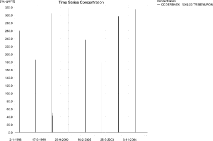
Figure 12.1. Concentration pattern over time for tribenuron methyl in the sandy Catchment.
Figur 12.1. Koncentrationsmønster som funktion af tid for tribenuron-methyl i det sandede opland.
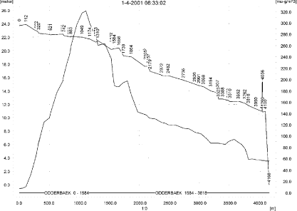
Figure 12.2. Concentrations of tribenuron methyl in the sandy catchment on 1. April 2001, 8.33.
Figur 12.2. Koncentrationer tribenuron-methyl i det sandede opland den 1. april 2001, 8.33.
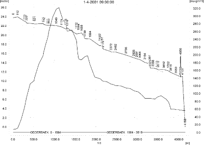
Figure 12.3. Concentrations of tribenuron methyl in the sandy catchment on 1. April 2001, 9.00.
Figur 12.3. Koncentrationer tribenuron-methyl i det sandede opland den 1. april 2001, 9.00.
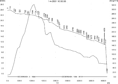
Figure 12.4. Concentrations of tribenuron methyl in the sandy catchment on 1. April 2001, 10.00.
Figur 12.4. Koncentrationer tribenuron-methyl i det sandede opland den 1. april 2001, 10.00.

Figure 12.5. Concentrations of tribenuron methyl in the sandy catchment on 1. April 2001, 12.00.
Figur 12.5. Koncentrationer tribenuron-methyl i det sandede opland den 1. april 2001, 12.00.
In order to present the data in a similar fashion to the FOCUS SW-results, data were extracted and recalculated for the time series marked in Table 12.2. The global maxima and time weighted concentrations (up to 7 days) were extracted and are reported in Table 12.3. Note that the unit is ng/l.
Table 12.3. Concentration (ng/l) of tribenuron methyl at selected points in the sandy stream.
Tabel 12.3. koncentration af tribenuron-methyl, ng/l, på udvalgte lokaliteter i det sandede vandløb.
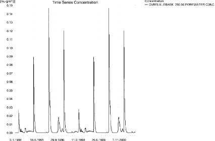
An example of the amount of pesticide sorbed to macrophytes is shown in Figure 12.6. The maximum value of 1.7 ng/l is reached 1421 m from the upstream end. The concentration does not significantly influence the concentration in the water phase- The porewater concentrations are shown in Figure 12.7. The sorption to sediment is <0.01 ng/kg.
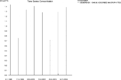
Figure 12.6. Typical concentration pattern for tribenuron methyl sorbed on macrophytes in the sandy catchment. The maximum value (1.71 ng/l) is reached 1421 m from the upstream end.
Figur 12.6. Typisk koncentrationsmønster af tribenuron-methyl sorberet på makrofytter i det sandede opland. Den maximalt opnåede værdi, ( 1.71 ng/l) is reached 1421 m fra den opstrøms ende.
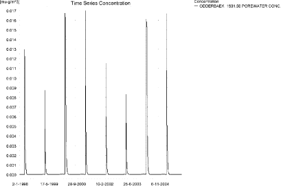
Figure 12.7. Pore water concentration of tribenuron methyl in the sandy catchment. The maximum concentration reached is 0.019 ng/l 1421 m from the upstream end.
Figur 12.7. Porevandskoncentrationer af tribenuron-methyl i det sandede opland. Den maximale koncentration (0.019 ng/l) er fundet 1421 m fra den opstrøms ende.
The global maximum value calculated by PestSurf for the sandy catchment in the water phase is 321 ng/l. This is considerably more than what is found in the D3-ditch scenario (95 ng/l). However, 112 m from the upstream end, the concentration only reaches 10 ng/l, which is considerably less than what is found in the D3-ditch.
Sediment concentrations are 11 ng/kg in the D3-ditch scenaro and below 0.01 ng/kg in the PestSurf sandy catchment.
Figure 12.8 shows the output of the Pestsurf Excel template. The template works with pre-defined data extraction points. The plot requires specification of a “lowest detection value” (ldc), which defines when a pesticide occurrence is defined as an event. The time series plot is identical to the time series shown earlier, and the graph in the upper right corner resembles the plot in Figure 12.2, but takes into account a longer period of time. A curve is generated when a downstream point reaches a concentration higher than the ldc. The programme then tracks the highest concentration for each calculation point in the stream within the last 24 hours. The plot in the lower right corner shows how many events have concentrations higher than a given value (ldc) for the selected monitoring points.
Table 12.4 shows part of the result sheet generated by the PestSurf Excel sheet. The selected table shows the point along the stream (of the pre-defined points) with the highest concentration. This value was, however, only 187 ng/l. Thus, the pre-defined points have not caught the highest concentration of the simulation, which was 321 ng/l.
Click here to see Figure 12.8.
Figure 12.8. Overview for tribenuron methyl in the sandy catchment generated by the PestSurf excel template. The max concentrations generated over the 24 hours are similar to the overviews in Figure 12.2 and Figure 12.3. The graph to the lower right shows how many events have concentrations higher than a given value for the selected monitoring points. Detection value was set to 0.05 ng/l.
Figur 12.8. Oversigt for tribenuron-methyl i det sandede opland genereret med PestSurf-excel-skabelonen. Den maximale koncentration genereret over 24 timer svarer til oversigten i Figur 12.2 og Figur 12.3. Grafen nederst til højre viser hvorm mange hændelser, der har koncentrationern højere end en given værdi for de prædefinerede lokaliteter. Detektionsgrænsen var sat til 0.05 ng/l.
Table 12.4. Part of the result sheet generated by the PestSurf Excel sheet. The selected table shows the point along the stream with the highest concentration recorded. The lowest detection value is 0.05 ng/l, toxicity to fish, daphnies and algae are set to 2, 10 and 20 ng/, respectively. The recorded peaks are shown in Figure 12.8.
Tabel 12.4. Uddrag af resultatpresentationen genereret af PestSurf-Excel-arket. Den udvalgte tabel viser det fordefinerede punkt langs med åen med højest koncentration. Detektionsgrænsen er sat til 0.05 ng/l mens toxicitetsværdierne for fisk, dafnier og alger er henholdsvis 2, 10 og 20 ng/l. De tabellerede hændelser er vist i Figur 12.8.
12.4.2 Sandy Catchment, pond
The concentration pattern is evaluated in the middle of the pond only, see Figure 12.9. The pond receives drift but the contribution through groundwater dominates the picture during the wet years 1998-1999, repeated in 2002-2003. The maximum concentration is 289 ng/l. Between the time of spraying and the max concentration occurring in the pond is 27 mm of rainfall in 1998 (2002) and 50 mm in 1999 (2003). The general water level in the catchment must be high during these periods to cause such a quick response.
Figure 12.9. Concentrations of tribenuron methyl in the sandy pond.
Figur 12.9. Koncentration af tribenuron-methyl i det sandede vandhul.
In Table 12.5, global maxima and time-weighted concentrations (up to 7 days) were extracted.
Table 12.5. Maximum concentrations (ng/l) of tribenuron methyl generated in the sandy pond.
Tabel 12.5. maximumkoncentrationer af tribenuron-methyl (ng/l) genereret for det sandede vandhul.
| Year | ODDER_POND 20.00, | |||
| Conc. | TWC | Date | ||
| 1998 | 1998 (global max) | 278 | 19-04-1998 | |
| 1 hour (after max) | ||||
| 1 day after sp.in. | 273 | 276 | ||
| 2 days | 269 | 273 | ||
| 4 days | 264 | 271 | ||
| 7 days | 266 | 267 | ||
| 1999 | 1999 (global max) | 289 | 19-04-1999 | |
| 1 hour (after max) | 288 | 288 | ||
| 1 day after sp.in. | 284 | 287 | ||
| 2 days | 267 | 279 | ||
| 4 days | 261 | 275 | ||
| 7 days | 269 | 271 | ||
| 2000 | 2000 (global max) | 14 | 01-01-2000 | |
| 1 hour (after max) | ||||
| 1 day after sp.in. | 13 | 14 | ||
| 2 days | 12 | 13 | ||
| 4 days | 12 | 13 | ||
| 7 days | 11 | 12 | ||
| 2001 | 2001 (global max) | 3 | 27-12-2001 | |
| 1 hour (after max) | ||||
| 1 day after sp.in. | 3 | 3 | ||
| 2 days | 3 | 3 | ||
| 4 days | 2 | 3 | ||
| 7 days | 3 | 3 | ||
| 2002 | 2002 (global max) | 278 | 19-04-2002 | |
| 1 hour (after max) | ||||
| 1 day after sp.in. | 273 | 276 | ||
| 2 days | 269 | 273 | ||
| 4 days | 264 | 271 | ||
| 7 days | 266 | 268 | ||
| 2003 | 2003 (global max) | 289 | 19-04-2003 | |
| 1 hour (after max) | 289 | 289 | ||
| 1 day after sp.in. | 284 | 287 | ||
| 2 days | 267 | 279 | ||
| 4 days | 261 | 276 | ||
| 7 days | 269 | 271 | ||
| 2004 | 2004 (global max) | 15 | 01-01-2004 | |
| 1 hour (after max) | ||||
| 1 day after sp.in. | 14 | 15 | ||
| 2 days | 13 | 14 | ||
| 4 days | 12 | 14 | ||
| 7 days | 11 | 13 | ||
| 2005 | 2005 (global max) | 3 | 27-12-2005 | |
| 1 hour (after max) | ||||
| 1 day after sp.in. | 3 | 3 | ||
| 2 days | 3 | 3 | ||
| 4 days | 3 | 3 | ||
| 7 days | ||||
| Global max | 289 | |||
| 1 hour (after max) | 289 | 289 | ||
| 1 day after sp.in. | 284 | 287 | ||
| 2 days | 269 | 279 | ||
| 4 days | 264 | 276 | ||
| 7 days | 269 | 271 | ||
The sorption to macrophytes is shown in Figure 12.10. The pattern follows closely the concentration in the water. The water concentration is marginally influenced by the presence of macrophytes. Time series of porewater concentration and tribenuron methyl sorbed to sediment is shown in Figure 12.11 and Figure 12.12. The maximum concentration reached in sediment is 3.1 ng/kg.
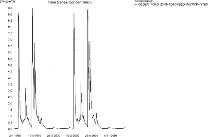
Figure 12.10. Sorption of tribenuron methyl to macrophytes in the sandy pond.
Figur 12.10. Sorption af tribenuron-methyl til makrofytter i det sandede vandhul.
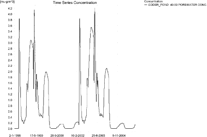
Figure 12.11. Tribenuron methyl concentration in the pore water in the sandy pond.
Figur 12.11. Porevandskoncentration af tribenuron-methyl i det sandede vandhul.
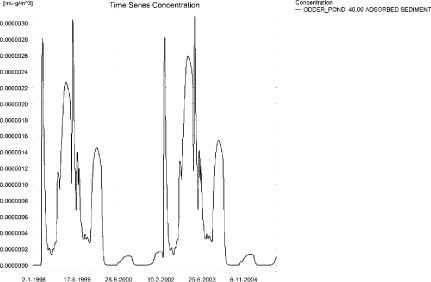
Figure 12.12. Sorption of tribenuron methyl to sediment in the sandy pond. The concentration is in µg/g sediment and not µg/m³ as stated.
Figur 12.12. Sorption af tribenuron-methyl til sediment i det sandede vandhul. Koncentrationen er i µg/g og ikke i µg/m³ som angivet.
Compared to the FOCUS D3-ditch, the concentration in the PestSurf sandy pond is considerably higher, 0.289 µg/l compared to 0.095 µg/l. The ditch-concentration is caused by wind drift, while the concentration in the sandy pond is caused by groundwater contribution.
With respect to sediment concentrations, it is opposite. The concentration in the D3-ditch reaches 11 ng/kg while PestSurf only reaches 3.1 ng/kg.
In the pond-case, there is no difference between the results of PestSurf and the results extracted by the templates. Figure 12.13 shows the output of the PestSurf Excel template. The template works with one pre-defined data extraction point for the pond (center of the pond). The plot requires specification of a “lowest detection value” (ldc) which defines when a pesticide occurrence is defined as an event. The time series plot is identical to the time series shown earlier. The plot to the right shows how many events have concentrations higher than a given toxicity value for the selected monitoring points.
Table 12.6 shows part of the result sheet generated by the PestSurf Excel sheet based on the ldc-value.
Click here to see Figure 12.13.
Figure 12.13. Overview for tribenuron methyl in the sandy pond generated by the PestSurf excel template. The time series shown is identical to the one in Figure 12.9. The detection value is set to 25 ng/l.
Figur 12.13. Oversigt for tribenuron-methyl i det sandede vandhul genereret med PestSurf-excel-skabelonen. Den viste tidsserie er mage til den i Figur 12.9. Detektionsgrænsen er sat til 25 ng/l.
Table 12.6. Part of the result sheet generated by the PestSurf Excel sheet, applied to Tribenuron methyl. The limiting value used for generation of the table is 25 ng/l. The toxicity values were set to 50,100 and 1000 ng/l, respectively. The recorded peaks are shown in Figure 12.13.
Tabel 12.6. Uddrag af resultatpresentationen genereret af PestSurf-Excel-arket. Grænseværdien anvendt til tabelgenerering er sat til 25 ng/l mens toxicitetsværdierne for fisk, dafnier og alger er henholdsvis 50, 100 og 1000 ng/l. De tabellerede hændelser er vist i Figur 12.13.
12.4.3 Sandy Loam catchment, Stream
The distribution of concentrations was assessed in several steps. First, the maximum concentrations at each calculation point were listed, and the dates for the occurrence of the maximum were assessed (Table 12.7). The points, for which the maximum value also represents a local maximum were selected for further analysis.
All points show the same type of time series pattern. The six points with highest maximum values were analysed further.
Table 12.7. Maximum concentrations (ng/l) of tribenuron methyl simulated for each calculation point in the sandy loam catchment.
Tabel 12.7. Maximumskoncentrationer (ng/l) af tribenuron-methyl simuleret for hvert beregningspunkt i morænelersoplandet.
| TRIBENURON METHYL | Maximum | Max.Time | Local Maxima |
| ALBJERGBAEK 0.00 | 11 | 02-04-1996 20:00 | |
| ALBJERGBAEK 150.00 | 33 | 05-04-1996 20:00 | |
| ALBJERGBAEK 300.00 | 56 | 05-04-1996 20:00 | |
| ALBJERGBAEK 450.00 | 62 | 04-04-2000 21:00 | |
| ALBJERGBAEK 600.00 | 255 | 31-03-2000 09:00 | |
| ELHOLTBAEK 0.00 | 6 | 02-04-1996 17:00 | |
| ELHOLTBAEK 165.00 | 7 | 02-04-1996 18:00 | |
| ELHOLTBAEK 330.00 | 205 | 31-03-2001 08:40 | |
| FREDLIGBAEK 0.00 | 13 | 29-04-1996 12:00 | |
| FREDLIGBAEK 100.00 | 20 | 29-04-1996 12:00 | |
| FREDLIGBAEK 200.00 | 22 | 28-04-2000 12:00 | |
| FREDLIGBAEK 300.00 | 22 | 28-04-2000 12:00 | |
| FREDLIGBAEK 400.00 | 22 | 28-04-2000 12:00 | |
| FREDLIGBAEK 500.00 | 21 | 28-04-2000 13:00 | |
| FREDLIGBAEK 600.00 | 22 | 28-04-2000 12:00 | |
| FREDLIGBAEK 667.50 | 22 | 28-04-2000 14:00 | |
| FREDLIGBAEK 735.00 | 426 | 31-03-2000 08:40 | x |
| GROFTEBAEK 0.00 | 5 | 02-04-1996 17:00 | |
| GROFTEBAEK 155.00 | 8 | 02-04-1996 18:00 | |
| GROFTEBAEK 310.00 | 9 | 02-04-1996 17:00 | |
| GROFTEBAEK 465.00 | 6 | 02-04-1996 18:00 | |
| GROFTEBAEK 620.00 | 353 | 31-03-2000 08:40 | x |
| STENSBAEK 0.00 | 29 | 02-04-1996 17:00 | |
| STENSBAEK 125.00 | 40 | 03-04-1996 05:00 | |
| STENSBAEK 250.00 | 12 | 02-04-1996 18:00 | |
| STENSBAEK 412.50 | 16 | 18-09-1998 00:00 | |
| STENSBAEK 575.00 | 85 | 31-03-2000 09:19 | |
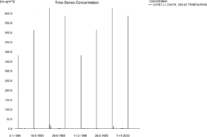
| OVRELILLEBAEK 0.00 | 14 | 02-04-1996 22:00 | |
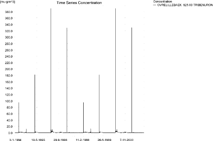
| OVRELILLEBAEK 125.00 | 553 | 31-03-2000 08:30 | x |
| OVRELILLEBAEK 250.00 | 434 | 31-03-2000 08:30 | |
| OVRELILLEBAEK 290.00 | 627 | 31-03-2000 08:30 | x |
| OVRELILLEBAEK 330.00 | 255 | 31-03-2000 09:00 | |
| OVRELILLEBAEK 330.00 | 255 | 31-03-2000 09:00 | |
| OVRELILLEBAEK 352.50 | 322 | 31-03-2000 09:10 | |
| OVRELILLEBAEK 375.00 | 85 | 31-03-2000 09:19 | |
| OVRELILLEBAEK 375.00 | 85 | 31-03-2000 09:19 | |
| OVRELILLEBAEK 437.50 | 95 | 31-03-2001 09:10 | |
| OVRELILLEBAEK 500.00 | 198 | 31-03-2000 08:30 | |
| OVRELILLEBAEK 625.00 | 390 | 31-03-2000 08:30 | x |
| OVRELILLEBAEK 750.00 | 255 | 31-03-2000 08:30 | |
| OVRELILLEBAEK 855.00 | 339 | 31-03-2000 08:30 | |
| OVRELILLEBAEK 960.00 | 205 | 31-03-2001 08:40 | |
| OVRELILLEBAEK 960.00 | 205 | 31-03-2001 08:40 | |
| OVRELILLEBAEK 980.00 | 217 | 31-03-2000 08:40 | |
| OVRELILLEBAEK 1000.00 | 181 | 31-03-2001 08:40 | |
| OVRELILLEBAEK 1062.50 | 183 | 31-03-2001 08:49 | |
| OVRELILLEBAEK 1125.00 | 170 | 31-03-2001 08:49 | |
| OVRELILLEBAEK 1187.50 | 197 | 31-03-2000 08:30 | |
| OVRELILLEBAEK 1250.00 | 190 | 31-03-2000 08:30 | |
| OVRELILLEBAEK 1425.00 | 275 | 31-03-2000 08:30 | x |
| OVRELILLEBAEK 1600.00 | 237 | 31-03-2000 08:30 | |
| OVRELILLEBAEK 1650.00 | 288 | 31-03-2000 08:30 | |
| OVRELILLEBAEK 1700.00 | 227 | 31-03-2000 08:40 | |
| NEDRELILLEBAEK 0.00 | 227 | 31-03-2000 08:40 | |
| NEDRELILLEBAEK 135.00 | 247 | 31-03-2000 08:30 | |
| NEDRELILLEBAEK 270.00 | 322 | 31-03-2000 08:30 | |
| NEDRELILLEBAEK 330.00 | 390 | 31-03-2000 08:30 | |
| NEDRELILLEBAEK 390.00 | 393 | 31-03-2000 08:30 | |
| NEDRELILLEBAEK 495.50 | 546 | 31-03-2000 08:30 | x |
| NEDRELILLEBAEK 601.00 | 426 | 31-03-2000 08:40 | |
| NEDRELILLEBAEK 601.00 | 426 | 31-03-2000 08:40 | |
| NEDRELILLEBAEK 693.00 | 427 | 31-03-2000 08:49 | |
| NEDRELILLEBAEK 785.00 | 404 | 31-03-2000 09:00 | |
| NEDRELILLEBAEK 847.00 | 513 | 31-03-2000 08:30 | x |
| NEDRELILLEBAEK 909.00 | 353 | 31-03-2000 08:40 | |
| NEDRELILLEBAEK 909.00 | 353 | 31-03-2000 08:40 | |
| NEDRELILLEBAEK 984.50 | 343 | 31-03-2000 09:19 | |
| NEDRELILLEBAEK 1060.00 | 425 | 31-03-2000 08:30 | |
| NEDRELILLEBAEK 1169.50 | 525 | 31-03-2000 08:30 | |
| NEDRELILLEBAEK 1279.00 | 747 | 31-03-2000 08:30 | x |
| NEDRELILLEBAEK 1409.50 | 614 | 31-03-2000 08:40 | |
| NEDRELILLEBAEK 1540.00 | 432 | 31-03-2000 09:19 | |
| global max | 747 |
All maximum concentrations are caused by drift events. Small drainage events are visible, particularly in the upstream part of the catchment. Figure 12.14 shows the concentration pattern for the upstream part of the catchment and Figure 12.15 for the lower part.
At the top end, two drainage events stand out in the simulations, 2-28 April 1996 and 2002, and the extreme event in September 1998. The April event is caused by 33 mm of rainfall on 2. April, the day after spraying and rain during the following period, see Table 12.8. This causes a drainage event on the 2. April, and the pesticide peak appears at its tail. The event on the 28 April causes another drainage event with pesticide occurrence.
Table 12.8. Rainfall in connection with tribenuron methyl peak in April 1996 and 2000.
Tabel 12.8. Nedbør i forbindelse med tribenuron-methyl-forekomst i april 1996 og 2000.
| April 1996 and 2002 | mm rainfall |
| 2 April | 33 |
| 5 April | 2.4 |
| 13 April l | 0.9 |
| 14 April | 0.6 |
| 15 April | 9.3 |
| 18 April | 4.8 |
| 25 April | 10.8 |
| 26 April | 6.6 |
| 27 April | 1.8 |
| 28 April | 13.5 |
| 29 April | 3.9 |
a)
b)
Figure 12.14. Concentration pattern for tribenuron methyl in Ovrelillebaek, 290 and 625 n m from the upstream end of the main stream in the upstream part of the sandy loam catchment.
Figur 12.14. Koncentrationsmønster for tribenuron-methyl i Øvre Lillebæk, 290 og 625 m frden øvre del af morænelersoplandet.
a)
b)
Figure 12.15. Concentration pattern for tribenuron methyl in the lower end of the sandy loam catchment.
Figur 12.15. Koncentrationsmønster for tribenuron-methyl i den nedre del af morænelersoplandet.
Three longitudinal profiles from a drift event are shown in Figure 12.16-Figure 12.18 depicts the concentrations on 31st March 2000. The thin black line represents the concentration, while the thick black line shows the maximum concentrations obtained during the simulations. In addition, the outline of the stream is shown.
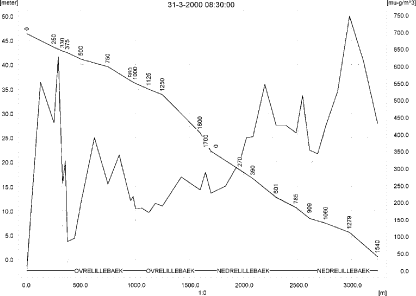
Figure 12.16. Concentrations in the the main stream of the sandy loam catchment on 31. March 2000, 8.30. The concentrations are generated by drift.
Figur 12.16. Koncentrationer i morænelersoplandet den 31. marts-2000, 8.30. Koncentrationerne skyldes drift.
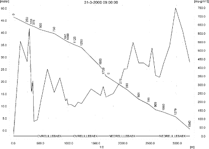
Figure 12.17 .Concentrations in the the main stream of the sandy loam catchment on 31. March 2000, 9.00.
Figur 12.17. Koncentrationer i morænelersoplandet den 31. marts-2000, kl. 9.00.
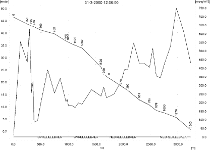
Figure 12.18. Concentrations in the the main stream of the sandy loam catchment on 31. March 2000, 12.00. The concentrations are negligible in most of the catchment.
Figur 12.18. Koncentrationer i morænelersoplandet den 31. marts-2000, kl. 12.00. Koncentrationerne er ubetydelige i det meste af oplandet.
To be able to extract comparable values to FOCUS SW, the global maxima and time weighted concentrations (up to 7 days) were extracted when these were meaningful (Table 12.9).
Figure 12.19 and b)
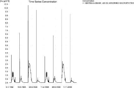
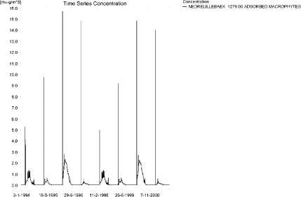
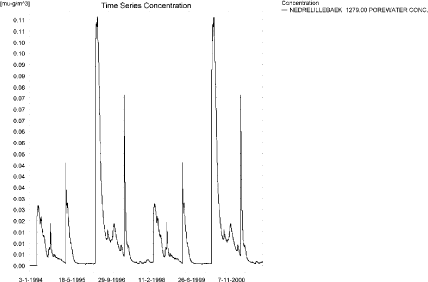
Figure 12.20 show the concentrations sorbed to macrophytes in the upper and lower part of the catchment. The highest value reached is 28 ng/l 125 m from the upstream end of the main stream. Figure 12.21 shows the concentration of pesticide in porewater. The highest concentration reached is 0.279 ng/l 125 m from the upstream end of the main stream.
Due to low sorption, the amount of tribenuron methyl adsorbed to sediment is <0.01 ng/kg in most of the catchment. The maximum concentration in sediment (0.18 ng/kg) is shown in Figure 12.22.
The pattern of sorption to macrophytes follows the pattern of the water concentrations. The concentration influences the concentration in the water phase significantly, particularly outside the periods of drift contributions.
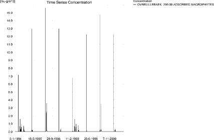
Figure 12.19. Concentration on macrophytes in OvreLillebaek. The pattern follows the pattern of concentrations in the stream.
Figur 12.19. Koncentration af tribenuron-methyl på makrofytter i Øvre Lillebæk. Mønsteret følger samme mønster som vandkoncentrationerne.
a)
b)
Figure 12.20. Concentration on macrophytes in ng/l in two points in NedreLillebaek. The pattern follows the pattern of concentrations in the stream.
Figur 12.20. Koncentration af tribenuron-methyl på makrofytter i to punkter i Nedre Lillebæk. Mønsteret følger samme mønster som vandkoncentrationerne.
a)
b)
Figure 12.21. Concentration of tribenuron methyl in porewater in the upstream and downstream ends of the sandy loam catchment. The maximum concentration reached in the catchment is 0.28 ng/l.
Figur 12.21. Koncentration af tribenuron-methyl i porevand i den opstrøms og nedstrøms ende af morænelersoplandet. Den maximale koncentration fundet i oplandet er 0.28 ng/l.
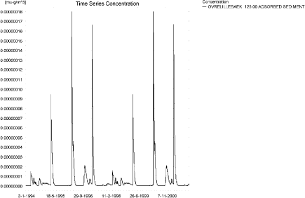
Figure 12.22. Maximum sediment concentration of tribenuron methyl in the sandy loam catchment. Note that the concentration is in µg/g and not µg/m³ as indicated.
Figur 12.22. Maximal sedimentkoncentration af tribenuron-methyl i morænelersoplandet. Bemærk at koncentrationen er i µg/g sediment og ikke µg/m³ som angivet.
FOCUS SW D4-stream reaches 76 ng/l while PestSurf generates 747 ng/l. Both models generate the maximum concentrations through wind drift. However, some drainage contribution does take place in the sandy loam stream. 125 m from the upstream end, the concentration reaches 553 ng/l. The water depth at the time of maximum concentration is around 4.8 cm. This, and the fact that the PestSurf stream is not rectangular, accounts for the difference between the two models.
For the sediment, the D4-simulations reach 2 ng/kg while PestSurf predicts a maximum of 0.18 ng/kg.
Figure 12.23, Figure 12.24, Table 12.10 and Table 12.11 show the results as generated by the PestSurf templates. The maximum value generated by the templates for the upper part of the stream is 288 ng/l, and for the lower part 747 ng/l. The maximum value generated in the (upstream part of the) catchment is 627 ng/l and for the lower part, 747 ng/l. Thus, the templates did catch the maximum concentration of the PestSurf simulation.
Table 12.9. Maximum concentrations (ng/l) of tribenuron methyl simulated for selected calculation point in the sandy loam catchment.
Tabel 12.9. Maximums koncentrationer (ng/l) af tribenuron-methyl for udvalgte lokaliteter i morænelersoplandet.
Click here to see Figure 12.23.
Figure 12.23. Overview for tribenuron methyl in the sandy loam catchment generated by the PestSurf excel template for the upstream part of the catchment. The detection value was set to 1 ng/l.
Figur 12.23. Oversigt for tribenuron-methyl genereret med PestSurf-excel-skabelonen for den opstrøms del af morænelers-oplandet. Detektionsgrænsen var sat til 1 ng/l.
Click here to see Figure 12.24.
Figure 12.24. Overview for tribenuron methyl in the sandy loam catchment generated by the PestSurf excel template for the downstream part of the catchment. The detection value was set to 1 ng/l.
Figur 12.24. Oversigt for tribenuron-methyl genereret med PestSurf-excel-skabelonen for den nedstrøms del af morænelers-oplandet. Detektionsgrænsen var sat til 1 ng/l.
Table 12.10. Part of the result sheet generated by the PestSurf Excel sheet for the upstream part of the sandy loam catchment. The lowest detection value is for generation of the table is 1 ng/l, toxicity to fish, daphnies and algae are set to 5, 10 and 100 ng/, respectively. The recorded peaks are shown in Figure 12.23.
Tabel 12.10. Uddrag af resultatpresentationen genereret af PestSurf-Excel-arket for den opstrøms del af morænelersoplandet. Detektionsgrænsen for tabelgenerering er 1 ng/l. Toxicitetsværdierne for fisk, dafnier og alger er henholdsvis 5, 10 og 100 ng/l. Hændelserne er vist i Figur 12.23.
Click here to see Table 12.10.
Table 12.11. Part of the result sheet generated by the PestSurf Excel sheet for the downstream part of the sandy loam catchment. The lowest detection value for generation of the table is 1 ng/l, toxicity to fish, daphnies and algae are set to 5, 10 and 100 ng/, respectively. The recorded peaks are shown in Figure 12.24.
Tabel 12.11. Uddrag af resultatpresentationen genereret af PestSurf-Excel-arket for den nedstrøms del af morænelersoplandet. Detektionsgrænsen for tabelgenerering er sat til 1 ng/l. Toxicitetsværdierne for fisk, dafnier og alger er henholdsvis5, 10 og 100 ng/l. Hændelserne er vist i Figur 12.24.
Click here to see Table 12.11.
12.4.4 Sandy loam catchment, pond
The concentration pattern is evaluated in the middle of the pond only, see Figure 12.25. The pond receives contributions mainly through drift, in good correspondence with the fact that it is situated in the upper part of the sandy loam catchment. However, some drainage contributions are visible in the wet periods. The maximum concentration is quite low, 10.3 ng/l.
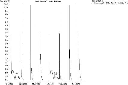
Figure 12.25. Concentrations of tribenuron methyl for the sandy loam pond.
Figur 12.25. Koncentration af tribenuron-methyl i morænelersvandhullet.
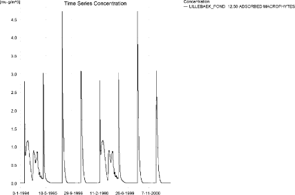
Figure 12.26. Tribenuron methyl sorbed to the macrophytes in the sandy loam pond.
Figur 12.26. Tribenuron-methyl sorberet til makrofytter i morænelers-vandhullet.
Figure 12.26 shows that the macrophytes participate in the regulation of the concentrations in the pond. The concentrations on macrophytes and in the water phase are comparable. The concentration in the porewater is shown in Figure 12.27. The adsorption to sediment is <0.01 ng/kg.
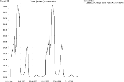
Figure 12.27. Tribenuron methyl in porewater in the sandy loam pond.
Figur 12.27. Tribenuron-methyl i porevand i morænelersvandhullet.
In Table 12.12, global maxima and time weighted concentrations (up to 7 days) were extracted.
Table 12.12. Actual and time weighted concentrations (ng/l) of tribenuron methyl in the sandy loam pond.
Tabel 12.12. Beregnede og tidsvægtede koncentrationer (ng/l) af tribenuron-methyl i morænelersvandhullet.
| Year | Tribenuron methyl | ActualConc. | Time-weightedConc. | Date |
| 1994 | global max | 6 | 02-04-1994 | |
| 1 hour(after max) | 5 | 5 | ||
| 1 day after sp.in. | 3 | 3 | ||
| 3 days | 2 | 3 | ||
| 4 days | 2 | 3 | ||
| 7 days | 1 | 2 | ||
| 1995 | Global max | 6 | 01-04-1995 | |
| 1 hour | 5 | 6 | ||
| 1 day | 3 | 4 | ||
| 2 days | 3 | 3 | ||
| 4 days | 3 | 3 | ||
| 7 days | 2 | 3 | ||
| 1996 | global max | 10 | 01-04-1996 | |
| 1 hour | 8 | 9 | ||
| 1 day | 5 | 6 | ||
| 2 days | 5 | 5 | ||
| 4 days | 4 | 5 | ||
| 7 days | 4 | 5 | ||
| 1997 | global max | 7 | 01-04-1997 | |
| 1 hour | 5 | 6 | ||
| 1 day | 3 | 4 | ||
| 2 days | 3 | 3 | ||
| 4 days | 3 | 3 | ||
| 7 days | 3 | 3 | ||
| 1998 | global max | 6 | 01-04-1998 | |
| 1 hour | 5 | 5 | ||
| 1 day | 3 | 3 | ||
| 2 days | 2 | 3 | ||
| 4 days | 2 | 3 | ||
| 7 days | 1 | 2 | ||
| 1999 | global max | 6 | 31-03-1999 | |
| 1 hour | 5 | 6 | ||
| 1 day | 3 | 4 | ||
| 2 days | 3 | 3 | ||
| 4 days | 3 | 3 | ||
| 7 days | 2 | 3 | ||
| 2000 | global max | 10 | 31-03-2000 | |
| 1 hour | 8 | 9 | ||
| 1 day | 5 | 6 | ||
| 2 days | 5 | 5 | ||
| 4 days | 4 | 5 | ||
| 7 days | 4 | 5 | ||
| 2001 | global max | 7 | 31-03-2001 | |
| 1 hour | 5 | 6 | ||
| 1 day | 3 | 4 | ||
| 2 days | 3 | 3 | ||
| 4 days | 3 | 3 | ||
| 7 days | 3 | 3 | ||
| max values | ||||
| global max | 10 | |||
| 1 hour | 8 | 9 | ||
| 1 day | 5 | 6 | ||
| 2 days | 5 | 5 | ||
| 4 days | 4 | 5 | ||
| 7 days | 4 | 5 |
The FOCUS SW-scenario D4-pond generates a concentration of 3 ng/l, which is in the same order of magnitude as the PestSurf sandy loam pond-concentration of 10 ng/l. Both maximum concentrations are generated through drift. The difference between the results of the two models is partly due to the higher exposure of the the PestSurf sandy loam pond and the fact that the water depth at the time of spraying is 0.75 cm.
With respect to sediment, the D4-scenario reaches 2 ng/kg while PestSurf predicts values < 0.01 ng/kg.
Figure 12.28 and Table 12.13 show output from the PestSurf template, with a time series identical to Figure 12.25.
Click here to see Figure 12.28.
Figure 12.28. Overview for Tribenuron in the sandy loam pond generated by the PestSurf excel template. The time series shown is identical to the one in Figure 12.25. The detection value used is 1 ng/l.
Figur 12.28. Oversigt for tribenuron-methyl i morænelersvandhullet genereret med PestSurf-excel-skabelonen. Den viste tidsserie er mage til den i Figur 12.25. Detektionsgrænsen er sat til 1 ng/l.
Table 12.13. Part of the result sheet generated by the PestSurf Excel sheet. The limiting value is set to 1 ng/l. The toxicity values for fish, daphnies and algae were set to 2, 10 and 100 ng/l, respectively. The recorded peaks are shown in Figure 12.28.
Tabel 12.13. Uddrag af resultatpresentationen genereret af PestSurf-Excel-arket. Detektionsgrænsen er sat til 1 ng/l. Toxicitetsværdierne for fisk, dafnier og alger er henholdsvis 2, 10 og 100 ng/l. De tabellerede hændelser er vist i Figur 12.28.
Click here to see Table 12.13.
Table 12.14. Summary of simulation results for tribenuron methyl.
Tabel 12.14. Opsummerede resultater for tribenuron-methyl.
Click here to see Table 12.14.
12.5 Summary of simulations
The maximum actual concentrations for all simulations are recorded in Table 12.14.
The concentrations generated for the sandy pond and stream are about a factor 3 higher than the concentrations generated for the FOCUS SW D3-ditch. The pond is influenced by groundwater, while the D3-ditch and the sandy stream are influenced by wind drift. The high concentration generated in the stream is caused by the fact that the total agricultural area is sprayed within 30 minutes. However, 112 m from the upstream end, the concentration only reaches 10 ng/l, which is considerably less than what is found in the D3-ditch (95 ng/l). The low concentration in PestSurf, however, is due to a combination of a 20 m wide buffer zone and a water depth at the time of maximum concentration of 13-14 cm.
The FOCUS SW D4-pond and the PestSurf sandy loam pond differ by a factor of 3. The diffence is caused by the higher exposure of the sandy loam pond and a lower water level during the dry year of the simulation.
With respect to the D4-stream and the sandy loam stream, FOCUS SW generates 76 ng/l while PestSurf generates 747 ng/l. Both models generate the maximum concentrations through wind drift. However, some drainage contribution does take place in the sandy loam stream. The high concentrations in PestSurf are generated due to accumulation of drift contributions along the stream. 125 m from the upstream end, the concentration reaches 553 ng/l. The water depth at the time of maximum concentration is around 4.8 cm. This, and the fact that the PestSurf stream is triangular, accounts for the difference between the two models.
The maximum value obtained between 500 and 1700 m from the upstream end is 390 ng/l.
Macrophytes influence the concentrations, particularly in the sandy loam pond, but to some extent also in the sandy loam stream.
With respect to sediment concentrations, the maximum value generated by FOCUS is 11 ng/kg and the maximum value generated by PestSurf 3.1 ng/kg. PestSurf values are consistently lower than the FOCUS-SW-values but both models results in low sorption values.
Version 1.0 December 2006, © Danish Environmental Protection Agency