MTBE. Undersøgelse af grundvandet nedstrømsidriftværende og tidligere benzinstationer
Summary and conclusions
Background
MTBE (Methyl-tertiær-butyl-ether) has been added to unleaded petrol since 1985. MTBE is characterized by high solubility, high mobility and a low degradability. Thus, contamination from petrol stations can be a considerable threat to the groundwater. A series of initiatives concerning the phasing out of MTBE has been started.
Experience from earlier investigations and research programme
Experience from earlier investigations in the county of Funen shows that MTBE was detected in the secondary groundwater at 62 out of 72 exami-ned petrol stations. In 65 % of the cases, the content of MTBE was higher than the quality criteria for ground water of 5 µg/l. The Danish EPA started a number of technological programmes on MTBE. One of these program-mes is the “Research programme on ground water pollution originating from petrol stations”, which forms the basis for the current project.
Observed lengths and widths of contaminated plumes from the research in the county of Funen have been combined with model simulations in the “Research programme on ground water pollution originating from petrol stations”. From this, plumes between 25 m and more than 100 m in length and between 10 and 35 in width have been estimated. From the estimated lengths and widths of the plumes, a research programme has been drawn up. The programme aims at detecting possible groundwater contamination with a certainty of 95% in borings done within the area of the petrol station.
First step in the research programme is the establishment of three to four borings situated as close to the bounds of the property as possible. The borings are screened in the shallow aquifer, water level is located, water samples for chemical analyses are sampled and hydraulic parameters are estimated. As well, it is estimated whether the aquifer is continuous and where a possible contaminated plume might be located. To detect the contaminated plume outside the property, two borings are placed at the boundary of the property, and two borings are placed in a distance from the source corresponding to half the estimated length of the plume, cf. diagram below.
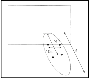
The length of the plume is determined from the soil type and hydraulic gradient found in the preliminary investigation. The water table of the new borings are logged and water is sampled for analyses.
Aims
The aims of the current project are:
- To carry out empirical investigations at five operating petrol stations, which have not previously been investigated, and at six closed down petrol stations, where contamination with petrol has previously been detected by OM.
- To focus on possible contamination with MTBE, but also to search for total hydrocarbons, C9-C10 aromatics and benzene, toluene, ethylbenzene, xylenes and naphthalene.
- To gather the experience and results obtained through the empirical investigations, in order to suggest possible adjustments to the report “Research programme on ground water pollution originating from petrol stations” before final publication.
- To upscale the results of the investigations to national scale.
Investigations
The fieldwork is divided into two phases: a preliminary investigation and a main investigation. For each of the eleven sites, it is assessed in the preliminary phase, whether the described and applied principles and methods have resulted in the expected knowledge on the plumes. Three borings are made at all sites. At three sites one or two extra borings are made in the preliminary investigations, in order to do a further examination of the hydro geological conditions. At one site, only a preliminary investigation is made, since it was not possible to locate a continuous aquifer within the top 20 m, which was maximum drilling depth.
In connection with the preliminary investigation it is assessed whether the research programme should be adjusted according to the “Research programme on ground water pollution originating from petrol stations”. With reference to achieving the optimum location for the borings in the main investigation, a preliminary assessment of the geological and hydro geological conditions is made at each site. If possible, it is assessed whether a possible contamination originates from a short-lived larger spill or a prolonged smaller spill. In the assessment of the spread of the contaminated plume the following four methods have been applied:
- Risk of type of spill
- Short-lived larger spill
- Prolonged smaller spill
- The rate of groundwater flow and the flow direction
- JAGG-calculations (at six sites)
- Flow path simulations (at five sites)
At three sites out of eleven, borings are not established in the plume in the main investigation. This is because of difficulties in the determination of the positions of the contamination plumes or because of very varying direction of the groundwater flow. At the remaining eight site two to four borings are made at the boundaries of the properties. At six of the sites a further two to four borings are made at half the estimated length of the plume, while no borings are made in the plume at two of the sites due to varying or presumed varying directions of groundwater flow.
It is crucial for the concept of the investigation, that a continuous aquifer can be located underneath the site. On the basis of the preliminary investigation it was assessed, that a continuous aquifer is present at eight of the eleven sites. After the supplementary information from the main investigations it was assessed, that a continuous aquifer is only present at five sites.
The possibilities to apply the concept at the individual sites are summarized in the table below.
| Site | Conclusion | |
| Closed down petrol stations, where pollution with petrol previously has been detected | Svendborg. Odensevej 135-137 |
The concept is not usable at the specific site, due to a very varying flow direction. A boring close to the source has been found to be heavily polluted with MTBE, but in borings close to the western boundaries of the property, only very low concentrations were found. This indicates, that the plume is not located, either because is has a different direction or because the length of the plume is shorter at the time of investigation |
| Svendborg. Bjerrebyvej 100 |
The concept is usable at the actual site from a hydro geological point of view, since the reservoir is continuous and only a small variation in flow direction and gradient has been seen. Pollution has earlier been detected in low concentrations in soil and groundwater at the source, but this could not be verified in the current investigation. Whether this is due to determination of the source (the concept does not allow for a migrating plume) or if the pollution has been diluted/decomposed is not known. | |
| Odense. Vollmose Allé 2 |
The concept is usable at the actual site, since the reservoir is continuous and only a small variation in flow direction and gradient has been seen. In addition to this at contaminated plume from a known contamination at the site has been located. | |
| Odense. Dalumvej 50 |
The concept is usable at the actual site, since the reservoir apparently is continuous, despite an inhomogeneous geology. Largely the same direction of flow has been registered in the various groundwater soundings. | |
| Kerteminde. Fynshovedvej 290 |
The concept is not usable at the actual site, since a continuous aquifer has not been found. The upper ground water is located in clayey till, where the ground water is expected to flow through cracks. | |
| Bogense. Vestergade 25A |
The concept is usable at the actual site, since the reservoir is continuous, despite inhomogeneity. In the first measuring round, at differing flow direction was registered. This was due to a screen with a slow response. A contaminated plume from a known contamination at the site has been located. | |
| Operation petrol stations | Svendborg. Odensevej 94 |
The concept is not usable at the actual site, since a continuous aquifer has not been found. In addition to this, a very small hydraulic gradient to the west of the site makes the estimation of flow direction and rate very uncertain. |
| Odense Hjallelsevej |
The concept is not usable at the actual site, since a continuous aquifer apparently has not been found. In addition to this, the water table below and southeast of the site is almost horizontal (very small gradient). A low content of MTBE has been found in the borings located in the plume. However, due to presumed varying directions of flow, the presence of a heavier MTBE pollution further west and northwest of the site can not be excluded. | |
| Vissenbjerg Kildebjerg Syd |
The concept is not usable at the actual site, since no continuous aquifer nor a uniform flow direction in the ground water has been found. | |
| Vissenbjerg Kildebjerg Nord |
The concept is not usable at the actual site, since no continuous aquifer nor a uniform flow direction in the ground water has been found. | |
| Vissenbjerg Østergade 11 |
The concept is not usable at the actual site. Only an isolated sandy pocket has been found directly below the petrol station. With no continuous aquifer under the whole site, no uniform direction of flow could be estimated. |
Rate of findings of MTBE
The MTBE rate of findings from the current investigation are compared with the findings of other investigations. It should be noticed, that the premises for the different investigations are not necessarily identical, cf. passage 5.1 and 5.2.
Despite of different premises, the compared investigation data from petrol stations no longer in use shows, that the probability to find MTBE-concentrations one level higher than the ground water quality criterion of 5 µg/l is 50 % or higher. The investigation data also shows a very high probability for the detection of low levels of MTBE in the ground water underneath this group of petrol stations. These low levels correspond to the MTBE concentrations between the level of detection and the ground water quality criterion. Summed up, the investigations show a very large probability to detect MTBE in the ground water at previous petrol stations, which have handled petrol added MTBE. The data from operating petrol stations are very sparse, and general conclusions can therefore hardly be made.
Adjustment to research programme
It is important to concentrate the efforts on the verification of the presence of a continuous aquifer with a uniform direction of flow. This will prevent unnecessary spending of resources on analyses etc. A targeted strategy for the investigations will be:
- Locating sources
- Assessment of flow direction from the topographical slope
- Establishment of three filter borings in the upper groundwater in sandy aquifers
- Carrying out ground water soundings three times
- Estimation of variations in flow direction and comparing to the expected
Provided that saturated sand is not found in all three borings or if there is a substantial difference between expected and found flow direction, the “conceptual investigations” are stopped. In stead, individual advanced investigations are planned at the site. At the rest of the sites the “conceptual investigations” are continued:
- Establishment of three additional filter borings (two in the direction of flow and one at the site, to support the geological model)
- Estimation of flow direction, gradient, hydraulic conductivity, reservoir parameters and flow rate
- Estimation of the contaminated plume from the empirical data and flow rate
Provided that the advanced preliminary investigation confirms the presence of a continuous sandy aquifer with a uniform flow direction, the main investigation including water analyses etc. are carried out. Four borings located in the plume in all are aimed for in the main investigation.
Version 1.0 Marts 2007, © Miljøstyrelsen.