|
Denmark's Third National Communication on Climate Change 2 National circumstances relevant to greenhouse gas emissions and removalsThe Kingdom of Denmark comprises Denmark, Greenland, and the Faroe Islands. The UN Framework Convention on Climate Change has been ratified on behalf of all three parts of the Kingdom, and this report therefore contains information on all three. However, at the present time, more information is available on Denmark than on the other parts of the Kingdom. Where tables, figures, and other information in this report also cover Greenland and/or the Faroe Islands, this is stated. 2.1. Denmark2.1.1 Form of government and structure of administrationDenmark is a constitutional monarchy, and the power of the state is divided between the legislative branch, the executive branch, and the judicial branch. According to the Kingdom’s Constitution, legislative power lies with the Folketing (the Danish Parliament), which consists of 179 members, two of whom are elected on the Faroe Islands and two in Greenland. The members are elected by the population for a period of normally four years. The executive branch – the government – cannot have a majority of the Folketing against it, and the government is often a majority government. The number of ministers in the government varies. Since 1973 Denmark has had a Minister for the Environment and a Ministry of the Environment. They conduct the international negotiations in the climate area on behalf of Denmark and also have the primary responsibility for coordination of legislation, plans, etc. with respect to climate. For the last ten years or so, other ministries have also worked with environmental and climate issues. In 1988 the government decided to follow up on the UN report on sustainable development – the Brundtland Report in which one of the main messages of which was the necessity of integrating the environmental issue into the administration within such sectors as transport, agriculture and energy. For this reason, a number of sector ministries have drawn up action plans in which the environment is an integral element. Examples are sector plans for energy, transport, agriculture, and development assistance. In the climate area, further to the previous government’s status report Climate 2012 from 2000, the government presented a overall status in connection with the presentation of its proposal for ratification of the Kyoto Protocol in April 2002. This status report was followed in February 2003 by a government proposal for a national climate strategy for Denmark, including analyses from the sector ministries, which was adopted by the Folketing on 13 March 2003. One of the main cornerstones of Danish democracy is autonomous local government, and specific environmental action takes place not only at national level but also at county and municipal level. The state sets the national rules and framework for environmental administration, while the counties and municipalities, working within this framework, plan and decide initiatives that implement and support the national legislation. The importance of local involvement is stressed in "Agenda 21 – a global agenda for sustainable development in the 21st century", which was adopted at the Rio Conference in 1992. The government supports the popular interest and participation in climate and environmental issues in different ways – including through implementation of the Pan-European Århus Convention and support for the local Agenda 21 work initiated by most of the Danish municipalities. 2.1.2 PopulationToday, Denmark has a population of slightly more than 5.3 million. As will be seen from table 2.1, population growth has been relatively small in the last 20 years. Table 2.1:
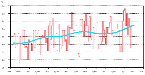
Source: Statistics Denmark The latest forecasts show that population growth will continue to be moderate in the years ahead. For example, the population is expected to reach 5.5 million in 2010, rising to 5.7 million in 2020. The low birth rate in the 1980s means that young people between the ages of 15 and 24 years make up only 11% of the population, while the elderly, between 50 and 64 years of age, account for 19%. Today, the population density is slightly more than 120 per km2. Two-thirds of Danish wage earners are employed in service trades, while 20% are employed in manufacturing. 2.1.3 GeographyDenmark consists of the Jutland peninsula and more than 400 islands. It has a total area of 43,075 km2 and lies at about 55º N and 11º E. The whole of the country is lowland. The surface was formed by Ice Age glaciers and glacial streams. The highest hill is approximately 170 metres above sea level. The coastline has a length of more than 7,400 km. To protect low-lying land against flooding and storm surge, it has been necessary to build dikes or other permanent installations along about 1,800 km of coastline. In addition, sandbags, breakwaters and similar protect other parts of the coastline, which would otherwise erode because they consist of soft materials deposited during the last Ice Age. A rise in the water level due to climate change would obviously affect the protection of the coasts and create a greater risk of flooding and erosion. The Danish landscape is indelibly stamped by the high population density. More than 60% of the land is used for agriculture or horticulture. Woodlands take up 11%, while towns, roads and scattered habitation take up 13%. The rest is nature, for example, lakes, bogs, heaths, and dunes. In relation to its size, Denmark is home to a wide variety of flora and fauna – in all, about 30,000 species. 2.1.4 ClimateDenmark has a temperate climate, with rainfall evenly distributed over the year. The country lies in the zone of prevailing westerly winds, which is characterised by fronts, low pressure, and changeable weather. Compared with other regions on the same latitude as Denmark, the climate is relatively warm due to the warm North Atlantic current that originates in the tropical sea off the east coast of the USA. As mentioned, Denmark has a distinctly coastal climate, with mild, damp winters and cool, unsettled summers. Average temperatures vary from about half a degree in winter to about 15 degrees in summer. However, the weather in Denmark is greatly affected by the proximity of both the sea and the continent. This means that the weather can change, depending on the prevailing wind direction. The west wind from the sea brings relatively uniform weather in summer and winter: mild in winter and cool in summer. When the wind comes from south or east, the weather in Denmark is more similar to that of the continent: warm and sunny in summer and cold in winter. The weather in Denmark thus depends very much on the wind direction and the season. Atmospheric pressure Average atmospheric pressure in Denmark shows seasonal variation, reaching a minimum in November and a maximum in May. Denmark’s highest-ever atmospheric pressure, 1062.5 hPA, was recorded in Skagen on 23 January 1907, while just one month later, on 20 February, the lowest atmospheric pressure in the history of Denmark was also recorded in Skagen, at 943.9 hPa. Temperature The annual mean temperature varies from year to year, from below 6ºC to more than 9ºC, with an average of 7.7ºC. The coldest year so far was 1879, with a mean temperature of 5.9ºC, while the hottest recorded year was 1990, with 9.3ºC. Since 1988, almost every year has been hotter than normal, and the temperature showed a sharply rising trend in the 1990s. Taken over the last 100 years, the temperature in Denmark has risen by about 0.5ºC, but the ten hottest years occurred from the 1930s to the 1990s.
Figure 2.1:
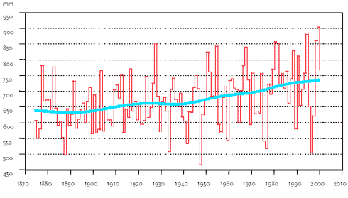
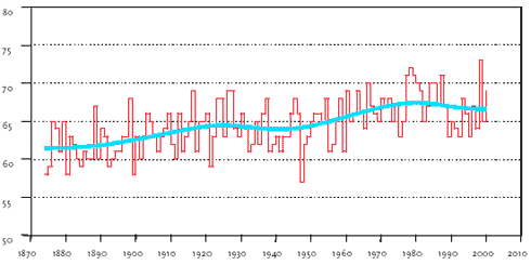
Figure 2.2:
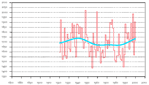
Figure 2.3:
Figure 2.4: The temperature in January and February averages around 0ºC but can vary greatly from 12ºC to below -31ºC. The average temperature in July and August is around 15ºC, but again can vary from below -3ºC to more than 36ºC. Precipitation Average annual precipitation varies greatly from year to year and from place to place. The lowest annual precipitation for the country as a whole was 464 mm in 1947, and the highest was 905 mm in 1999, while the average annual precipitation is 712 mm. The wettest months are normally September, October, and November, while the driest are February to May. In the winter months, the precipitation is sometimes in the form of snow. Annual precipitation in Denmark has on average increased by about 80 mm since 1940. Hours of sunshine and cloud cover On average, Denmark as a whole has about 1,701 hours of sunshine annually, but as in the case of the precipitation, this figure varies greatly from year to year. The sunniest year was 1947, with 2,022 hours, and the least sunny was 1954, with 1,437 hours. December is the least sunny month, with less than 40 hours of sunshine in most places, while June is the sunniest, with an average of 250 hours. Average annual cloud cover is 67%. 146 days are cloudy, i.e. with cloud cover at >80% and only 31 days are clear, with cloud cover at <20%. Since 1980, the trend has been towards more hours of sunshine and less cloud cover. Wind Countrywide, annual mean wind velocity is 5.8 m/s, and the wind is most frequently from westerly directions, from which about 25% of all winds come. The number of days with severe wind (>10.8 m/s) varies from about 30 in some places inland to almost 170 days at Skagen. On average, storm-force (> 24.5 m/s) occurs along the Danish coasts every three to four years. In December 1999 large parts of Denmark were hit by the worst-ever measured hurricane, and in some places mean wind velocities (average over 10 minutes) of more than 40 m/s were recorded, with gusts of up to 50 m/s. 2.1.5 EconomySince 1993 Denmark has benefited from considerable economic growth, with GNP (Gross National Product) rising at an average of 2.7% per year. In 2000 GNP was more than DKK 1,300 billion, corresponding to DKK 245,000 per capita. (1 Euro equals approximately DKK 7.4). In 2000 the public debt stood at 47% of GNP, compared with 78% in 1993. In the same period, foreign debt was reduced from 32% of GNP to 17%. From table 2.2, which shows key figures for the Danish economy, it will be seen that Denmark has a very open – and thus sensitive economy, in which exports account for a substantial part of total demand. In addition, public expenditure accounts for a large part of GNP. Tabel 2.3 shows the business sector’s contribution to GNP Table 2.2:
|
|||||||||||||||||||||||||||||||||||||||||||||||||||||||||||||||||||||||||||||||||||||||||||||||||||||||||||||||||||||||||||||||||||||||||||||||||||||||||||||||||||||||||||||||||||||||||||||||||||||||||||||||||||||||||||||||||||||||||||||||||||||||||||||||||||||||||||||||||||||||||||||||||||||||||||||||||||||||||||||||||||||||||||||||||||||||||||||||||||||||||||||||||||||||||||||||||||||||||||||||||||||||||||||||||||||||||||||||||||||||||||||||||||||||||||||||||||||||||||||||||||||||||||||||||||||||||||||||||||||||||||||||||||||||||||||||||||||||||||||||||||||||||||||||||||||||||||||||||||||||||||||||||||||||||||||||||||||||||||||||||||||||||||||||||||||||||||||||||||||||||||||||||||||||||||||||||||||||||||||||||||||||||||||||||||||||||||||||||||||||||||
Sector |
Gross increase in value |
% |
Agriculture etc. |
29,875 |
2.3 |
Mining etc. |
24,773 |
1.9 |
Industry |
195,395 |
14.9 |
Utilities |
23,088 |
1.8 |
Building and construction |
52,637 |
4.0 |
Distribution, hotels, restaurants, etc. |
169,405 |
12.9 |
Transport, postal services and telecommunication |
102,751 |
7.8 |
Finance and insurance |
62,229 |
4.7 |
Housing |
95,342 |
7.2 |
Leasing and estate agency services and business services |
122,290 |
9.3 |
Public and personal services |
294,044 |
22.4 |
Indirectly measured financial services |
-39,749 |
-3.0 |
(Product taxes minus product subsidies) |
183,445 |
13.9 |
Gross National Product |
1,315,526 |
100 |
Source: Statistics Denmark
Today, more than 10% of the demand for energy is supplied by renewable energy. The renewable energy resources are mainly wind energy and biomass, which are used to produce electricity, combined heat and power, or district heating. Internationally, Denmark is among the leading nations in wind energy.
Table 2.4:
Degree of self-sufficiency in %
|
1980 |
1988 |
1990 |
1994 |
1998 |
2000 |
2001 |
Energy, total |
5 |
42 |
52 |
76 |
102 |
139 |
137 |
Oil |
2 |
53 |
72 |
111 |
130 |
203 |
197 |
Oil and natural gas |
3 |
67 |
85 |
123 |
139 |
189 |
186 |
Source: Danish Energy Authority
Energy consumption
Despite the economic growth, total energy consumption has remained largely unchanged at approximately 800 PJ in the last ten-year period, cf. tables 2.6 and 2.7.
Denmark’s dependence on oil and coal has fallen. Particularly in the production of electricity and heat, oil and coal have been substituted with other fuels. Thus, natural gas, waste and biomass are increasingly being used in small-scale and industrial CHP plants, natural gas and renewable energy is increasingly being used in large scale electricity production, and natural gas is increasingly being used for individual heating of buildings.
Figure 2.5 shows adjusted energy consumption, sector by sector. In the last 20 years relative consumption by the transport sector has risen, whereas relative domestic sector consumption has fallen.
Structure of the market
The structure of the market in the energy sector is characterised by a division between electricity, gas, and district heating supply.
Table 2.5:
Energy production in PJ
|
1980 |
1988 |
1990 |
1994 |
1998 |
2000 |
2001 |
Production, total |
40 |
349 |
425 |
635 |
857 |
1163 |
1138 |
Crude oil |
13 |
202 |
256 |
389 |
492 |
765 |
726 |
Natural gas |
0 |
97 |
116 |
182 |
295 |
308 |
318 |
Renewable energy etc. |
28 |
49 |
53 |
64 |
74 |
88 |
94 |
Source: Danish Energy Authority
Table 2.6:
Actual energy consumption in PJ
|
1980 |
1988 |
1990 |
1994 |
1998 |
2000 |
2001 |
Energy consumption, total |
830 |
789 |
752 |
844 |
855 |
812 |
829 |
Oil |
555 |
375 |
343 |
358 |
376 |
367 |
366 |
Natural gas |
0 |
67 |
76 |
115 |
179 |
187 |
194 |
Coal |
252 |
282 |
255 |
325 |
236 |
166 |
175 |
Renewable energy etc. |
27 |
49 |
53 |
64 |
80 |
90 |
96 |
Net import of electricity |
-4 |
15 |
25 |
-17 |
-16 |
2 |
-2 |
Source: Danish Energy Authority
Table 2.7:
Gross energy consumption, breakdown by fuels, adjusted for inter-annual temperature
variations and net export in PJ
|
1980 |
1988 |
1990 |
1994 |
1998 |
2000 |
2001 |
Gross energy consumption, total |
816 |
818 |
820 |
829 |
839 |
837 |
831 |
Oil |
548 |
379 |
356 |
346 |
379 |
375 |
369 |
Natural gas |
0 |
69 |
83 |
117 |
182 |
193 |
193 |
Coal |
241 |
320 |
326 |
301 |
198 |
177 |
173 |
Renewable energy etc. |
27 |
50 |
55 |
65 |
81 |
92 |
96 |
Source: Danish Energy Authority
More than two-thirds of Denmark’s electricity supply comes from large primary power stations and CHP plants. Just under one-third is supplied by small-scale and industrial CHP plants and wind turbines. The large primary power stations are organised in two companies, which are owned by around 80 regional grid companies whose owners are municipalities, limited liability cooperatives, independent institutions, etc. The small-scale plants are primarily organised in municipally owned and consumer-owned district heating companies. The wind turbines are primarily privately owned or owned by the electricity companies.
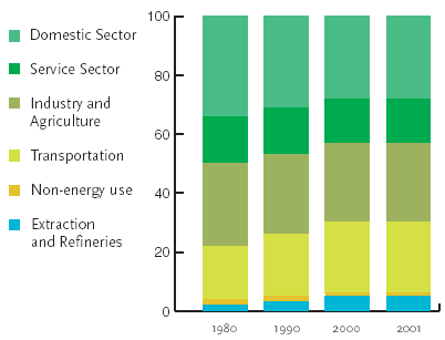
Figure 2.5:
Adjusted energy consumption, breakdown by sector
Source: Danish Energy Authority
In connection with the implementation of the EU Directive on liberalisation of the electricity sector, a reform of the sector has been carried out. As part of the reform, the market was fully opened on 1 January 2003, which means that all electricity customers can now use the electricity supplier of their choice.
Figure 2.6:
Energy prices for domestic users in current prices in DKK
Source: Danish Energy Authority
Most production of natural gas and oil is taken care of by a private company, DUC (Dansk Undergrunds Consortium), while the state-owned company DONG (Dansk Olie og Naturgas) takes care of the transportation of natural gas to the shore. DONG also owns and operates the national transmission grid for natural gas and part of the distribution grid. In addition, three regional gas companies under municipal ownership, own and operate regional natural gas grids, with distribution to the end users.
In the gas sector, too, a law reform has been passed to implement the EU Directive on liberalisation of the gas market, and the government’s aim is for the gas market to be open for all gas customers from 1 January 2004.
Approximately half of the demandfor heating is supplied by district heating. The heat is supplied from primary and small-scale CHP plants, waste incineration plants and biomass-fired district heating stations. Apart from the primary plants, the plants are owned either by municipalities or by local cooperatives that are owned by the consumers. Initially, district heating will not be covered by the liberalisation process, but the government will investigate whether it is possible in the longer term to have a more free choice of supplier in areas with large, interconnected district heating grids.
Prices and taxes
Energy prices are one of the key factors governing energy consumption. In 2000 total spending on energy, including taxes and VAT, amounted to DKK 118.1 billion. Of this figure, domestic users paid DKK 56.2 billion, manufacturing industries DKK 27.7 billion, and the commercial sector and the service industries, including public services, DKK 24.5 billion. As a general rule, enterprises subsequently receive a full refund of energy taxes and VAT, but not of CO2 taxes.
Figures 2.6 and 2.7 show the energy prices paid by domestic users. Figure 2.6 shows the current consumer prices, including taxes and VAT. Figure 2.7 shows the development in fixed 2001 prices. The fixed prices have been adjusted for the change in general prices according to the consumer price index.
The prices of heating oil and natural gas follow each other because this is laid down by law. The tax on petrol has varied considerably over time, which has affected the price of petrol.
Measured in fixed prices, the prices of petrol, heating oil and natural gas fell from 1980 until the early 1990s, cf. figure 2.7. The price of electricity remained relatively constant for the whole of the period, although with a rising trend in the later years, primarily because of higher taxes.
As an added incentive to enterprises to improve their energy efficiency, a green tax package with gradually increasing CO2 and energy taxes was introduced in 1996. Enterprises with a particularly high energy consumption can contract with the Danish Energy Authority on energy-efficiency improvements in return for a discount in the CO2 taxes.
In 2000 the revenue from energy taxes amounted to DKK 33.0 billion, up from DKK 31.9 billion in 1999. The largest contribution, DKK 10 billion, comes from petrol. Total revenue has increased by 140% in relation to 1990, when there were no CO2 and sulphur taxes. In 2000 energy taxes accounted for more than 5% of total tax revenue.
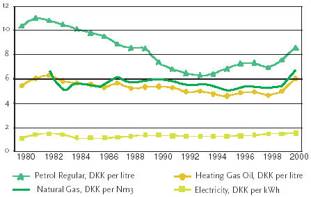
Figure 2.7:
Energy prices for domestic users. Fixed 2001 prices in DKK
Source: Danish Energy Authority
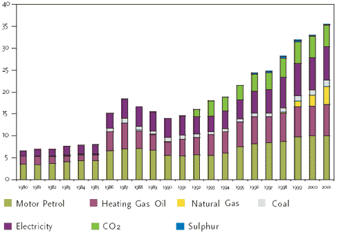
Figure 2.8:
Revenues from energy, CO2, and sulphur taxes. Current prices in billion DKK
Source: Danish Energy Authority
Trade
In 2000 net foreign exchange earnings from energy products amounted to DKK 13.1 billion. There was a profit on the trade in oil, natural gas, and electricity, but a loss on the trade in coal.
2.1.7 Transport
Efficient and flexible transportation of goods and persons is a vital element of the foundation of the modern welfare society. At the same time, transport is in itself an important economic sector that contributes to economic growth, employment, and foreign exchange earnings.
The positive effects of the transport sector must be seen against the fact that the sector burdens society in different areas – traffic accidents, air pollution, noise, congestion, and CO2 emissions. In Denmark, this burden has been reduced in some important areas – primarily in the form of better traffic safety and less air pollution – at the same time as traffic has increased.
Table 2.8:
Import and export of energy
However, there has not been a corresponding development with respect to CO2, and the transport sector has not yet succeeded in decoupling economic growth and greenhouse gas emissions, as has been done in the energy sector. Transport activity, energy consumption and CO2 emissions within the transport sector have developed largely in step with economic growth. One reason for this is that a number of measures that have been used in other sectors, e.g. the energy sector, including efficiency improvement and substitution of energy sources, have not been directly available or have been associated with heavy costs in the transport sector.
The developments in passager and goods transport activities are shown in table 2.9 and 2.10 respectively In 2001 the transport sector’s CO2 emissions were approximately 18% higher than the level in 1990. In 2001 the transport sector accounted for about 22% of Denmark’s total CO2 emissions. Its contribution to Denmark’s total greenhouse gas emissions are calculated as a share of the total emissions of greenhouse gases, which include industrial gases, methane, and nitrous oxide. Calculated in this way, the sector is responsible for about 18% of total emissions. The trend in CO2 emissions in the transport sector is therefore of considerable importance to the total trend in the greenhouse gas emissions.
Table 2.9:
Trend in passenger transport activity, in bill. person km
|
1970 |
1975 |
1980 |
1985 |
1990 |
1995 |
2000 |
2001 |
Aircraft |
0.2 |
0.3 |
0.4 |
0.4 |
0.5 |
0.5 |
0.4 |
0.4 |
Trains |
2.8 |
3.1 |
4.4 |
4.8 |
4.7 |
4.7 |
5.4 |
5.4 |
Ferries |
0.5 |
0.5 |
0.5 |
0.5 |
0.6 |
0.6 |
0.2 |
0.2 |
Cars |
33.4 |
37.8 |
38.6 |
43.2 |
50.3 |
54.0 |
59.8 |
59.3 |
Buses |
4.6 |
5.7 |
7.3 |
8.8 |
7.6 |
9.1 |
9.1 |
9.1 |
Total |
41.5 |
47.4 |
51.2 |
57.7 |
63.7 |
68.9 |
74.9 |
74.4 |
Bicycles |
|
|
|
4.5 |
5.4 |
5.2 |
|
|
Source: Ministry of Transport
Table 2.10:
Trend in goods transport activity, bill. tonne km
|
1970 |
1975 |
1980 |
1985 |
1990 |
1995 |
2000 |
2001 |
Freight trains |
1.3 |
1.2 |
1.2 |
1.2 |
0.6 |
0.6 |
0.5 |
0.5 |
Freighters |
1.8 |
1.7 |
1.9 |
1.8 |
1.9 |
2.2 |
1.8 |
1.8 |
Lorries |
7.8 |
9.5 |
8.8 |
9.4 |
9.4 |
9.4 |
11.1 |
11,0 |
Vans |
|
|
|
|
0.4 |
0.5 |
0.6 |
0,7 |
Pipelines1 |
|
|
|
0.9 |
1.9 |
2.9 |
|
|
Total |
10.9 |
12.4 |
111.9 |
12.4 |
14.2 |
15.6 |
14,0 |
14,0 |
Note: 1 Pipelines not included
Goods transport by air accounts for only a small proportion of total goods transport.
Source: Ministry of Transport
2.1.8 Business sector
In Denmark the production value of industry is approximately 30% of total national production. Table 2.11 shows that the largest industries in Denmark are the food, drink and tobacco, engineering, electronics, and the chemical industry.
The business sector as a whole (industry, building and construction, and public and private services) accounts for around 13% of Denmark’s total emissions of greenhouse gases. CO2 from energy consumption accounts for by far the largest part of these emissions, but the sector is also a direct source of emissions of industrial greenhouse gases.
In Denmark, the industrial sector’s energy consumption accounts for about 20% of total energy consumption. This 20% does not include energy consumption for transport and space heating.
The sector’s energy consumption has varied greatly over the last 20 years. Up to 1983, consumption fell considerably due to increases in the price of oil. When oil prices fell in 1986, energy consumption began rising again. In the period 1990-2001 energy consumption in the industrial sector rose by just under 9%, while electricity consumption in the same period increased by almost 22%.From 2000 to 2001 energy consumption rose by just under 2% owing to a considerably higher level of activity. Since 1994 energy consumption per produced unit has fallen,see figure 2.9.
Table 2.11:
Turnover by industry in 2002, DKK mill.
All industry |
517,551 |
Mining etc. |
2,437 |
Food, drink and tobacco |
131,628 |
Textiles, clothing and leather |
12,687 |
Timber/wood-working |
11,949 |
Paper and graphic industry |
36,849 |
Mineral oil etc. |
14550 |
Chemical industry |
60,543 |
Rubber and plastics |
20,626 |
Stone, clay and glass |
16,529 |
Metal production and metal-working |
40,450 |
Engineering |
62,500 |
Electronics |
61,914 |
Means of transport |
17235 |
Furniture industry and other industry |
27,655 |
Source: Statistics Denmark
The main action against the industrial sector’s energy consumption has hitherto been based on the green tax package for businesses passed by the Folketing in 1995. The package contained a combination of taxes and rebates to enterprises through, among other measures, government grants to promote energy savings by enterprises.
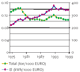
Figure 2.9:
Energy and electricity intensity in the industrial sector, based on energy data
adjusted for inter-annual temperature variations
Source: Danish Energy Authority and Odyssee
The development in the last few years since the introduction of the green tax package shows that it is possible to increase industrial growth without a corresponding increase in energy consumption and CO2 emissions. On the contrary, during increased growth it has proven possible to keep energy consumption constant and reduce CO2 emissions from energy consumption by the industrial sector.
For industrial greenhouse gases (HFCs, PFCs and SF6), regulation through taxes, and rules on phasing out the use of these substances have been implemented. With certain exceptions, the phasing-out process is expected to take place in the period 2003-2006.
2.1.9 Waste
The waste sector’s contribution to the emissions of greenhouse gases consists only of methane. Methane emissions come from the decomposition of organic waste at landfill sites. Emissions of the industrial gases HFC and SF6 from disposal of, for example, refrigerators and certain thermal glazing, which contain these substances, are included under the business sector.
There are also CO2 emissions in connection with disposal of oil-based products, e.g. packaging, plastic bags, etc. Since waste incineration in Denmark is included in energy production, these CO2 emissions must be included under the energy sector in accordance with the inventory rules from the IPCC.
Methane emissions from the waste sector are expected to fall in the future because the municipalities are now obliged to assign all waste suitable for incineration to incineration plants. This means that only a small quantity of organic waste will be deposited at landfills compared with the quantity deposited before the introduction of this obligation in 1997.
In addition, gas from a number of landfills is being used in energy production, which contributes to reducing both CO2 and methane emissions.
Table 2.12:
Key figures for building stock in the year 2001, in mill. m2
Total built-up area |
Buildings for all-year habitation |
Factories and workshops |
Commerce, trade and administration |
Institutions and buildings for cultural purposes |
Farm buildings |
653.6 |
329.4 |
52.9 |
58.9 |
39.3 |
130.8 |
Source: Statistics Denmark
Finally, in connection with incineration, some of the waste is used as an energy source. As many of the incineration plants as possible have been converted to CHP production. In other words, the heat is used to supply district heating, and the electricity is sold to electricity suppliers. In 2001, 32 incineration plants in Denmark converted 25% of the entire waste production and contributed 3% of the entire Danish energy production.
2.1.10 Buildings and urban structure
One-twentieth of the area of Denmark is urbanised. 85% of Danes are town-dwellers, and most enterprises, institutions, etc., are situated in owns. Many pollution problems are therefore concentrated in the towns.
Today, the total built-up area is 654 mill. m2. Table 2.12 shows the distribution of the area between housing, factories, offices, etc.
Today, about 16,000 homes are built per year, which is one-third of the number built in the first half of the 1970s. House building is expected to remain at this level. In recent years, house building has accounted for slightly more than half of all investment in building activities, and about half of the investment in the housing sector has gone on alterations and extensions. Building for industry and commerce now accounts for around half of all building in towns.
Table 2.13:
Development in the main forms of heating in buildings, in % of total heated space
Year |
1981 |
1991 |
2001 |
Heated space, total |
100 |
100 |
100 |
District heating |
29.4 |
38.6 |
47.5 |
Central heating with oil |
57.2 |
37.4 |
23.7 |
Central heating with natural gas |
|
9.0 |
15.9 |
Furnaces fired by oil and similar |
2.2 |
1.5 |
0.9 |
Other heating |
5.8 |
5.6 |
4.5 |
Source: Statistics Denmark
Towns and cities are generally characterised by separation of residential and industrial areas, industrial buildings being situated in specially designated zones on the outskirts of the towns. The growth in the service industries and the growth in manufacturing with a small environmental impact imply new possibilities for integrating industry and housing, thereby reducing the need for transport between home and work.
Table 2.14:
Use of agricultural land, livestock, and nitrogenous fertiliser
|
1970 |
1980 |
1990 |
1999 |
2001 |
Grain (%) |
59 |
62 |
56 |
55 |
57 |
Pulses and industrial seed (%) |
2 |
4 |
14 |
8 |
4 |
Root crops (%) |
10 |
8 |
8 |
5 |
4 |
Grass and greenfeed in rotation (%) |
17 |
14 |
12 |
16 |
16 |
Permanent grass (%) |
10 |
9 |
8 |
13 |
14 |
Other crops (%) |
2 |
3 |
2 |
3 |
5 |
Cattle (1000) |
2842 |
2961 |
2239 |
1887 |
1906 |
Pigs (1000) |
8361 |
9957 |
9497 |
11626 |
12608 |
Sheep (1000) |
70 |
56 |
159 |
143 |
152 |
Poultry (1000) |
19169 |
15507 |
16249 |
21010 |
21236 |
Nitrogen in fertilisers (1000 tonnes N) |
271 |
394 |
400 |
263 |
234 |
Nitrogen in manure (1000 tonnes N) |
- |
- |
251 |
237 |
264* |
Source: Danish Institute of Agricultural Sciences, Danish Research
Institute of Food Economics, Statistics Denmark.
* Data for the year 2000
Approximately two-thirds of the total building space is heated. The main forms of heating are district heating and central heating based on oil and natural gas. Half of the heated space is heated by district heating and, as seen from table 2.13, the use of both district heating and natural gas has increased at the expense of oil.
2.1.11 Agriculture
In the last 40 years the area used for agriculture has fallen from 72% (30,900 km2) of the total area in 1960 to 62% (26,756 km2) in 2000. Table 2.14 shows the breakdown by type of crop over the last 30 years. The proportion of agricultural land under grass and greenfeed in rotation and permanent grass fell considerably from 1970 to 1990, but rose considerably during the 1990s, due partly to increasing use of grass fields for dairy farming, and partly to the change in EU subsidy schemes, which means that grass or industrial seed must be grown on set-aside land.
From 1980 to 2001 the number of farms fell from 119,155 to 53,489. In the same period the average size of farms increased from 24 ha to 50 ha. This development has reduced the importance of agriculture to employment and the national economy. However, agricultural production has grown, both in quantity and value, and agricultural exports still make up a large proportion - 11% - of Denmark’s total exports.
During the 1990s interest in organic farming increased considerably. In 2001 organic farms accounted for approximately 5% of land under cultivation.
In the last 30 years use of nitrogen by agriculture has varied greatly, cf. table 2.14. Up to 1990 there was a big increase in the use of nitrogenous fertiliser, but during the 1990s use of this type of fertiliser fell considerably, and in 2001 nitrogen consumption was below the 1970 level. The nitrogen content of manure has probably remained approximately unchanged in the entire period in question. Consumption of phosphorus and potassium in fertilisers fell throughout the period.
The cattle population fell by 33% from 1970 to 2001, cf. table 2.14. Most of the cattle are dairy cows. Since milk production remained approximately unchanged throughout the period, the fall in cattle population is due to higher productivity per animal. In the same period, the pig population increased by 51%. The sheep population has doubled in relation to 1970, while after falling during the 1980s, the poultry population is now higher than it was in 1970.
Agriculture was responsible for 20% of Denmark’s total emissions of greenhouse gases in 2001. The proportion is expected to be down at 16% in 2010. The gases are mainly methane and nitrous oxides. CO2 from fuel consumption in the agricultural sector accounts for 3.6% of total Danish emissions.
2.1.12 Forestry
Approximately 11% of Denmark is forested. Originally focus was mainly on the potential of conifers, but in recent years focus has changed towards indigenous, deciduous tree species as offering greater long-term production and nature potential. Denmark’s forests are managed as closed canopy forests. The main objective is to ensure sustainable and multiple-use management of the forests and to manage them in line with the overall management of the countryside. Instead of clear-cut systems, forest owners are to a higher degree applying near-to-nature forest management regimes. Unlike our Scandinavian neighbours, Denmark is not a country in which forestry plays an important role in the national economy.
The Danish Forest Act protects a very large part of the existing forests against conversion to other landuses. Afforestation, for which public subsidies are made available, is as standard protected as forest reserve. In principle, this means that most of the forested land in Denmark will remain as forest.
A target has been set of 20-25% of Denmark being forest landscapes by the end of the 21st century. A considerable increase in the forest area is therefore to be achieved.
Denmark is the only part of the Kingdom in which forestry is practised. Greenland and the Faroe Islands have almost no forest.
2.2 Greenland
2.2.1 Form of government and administrative structure
Greenland has had home rule since 1979. The Home Rule Government consists of a directly elected parliament (the Landsting), comprising 31 members. A general election is held every four years. The Landsting elects a government (the Landsstyre), which is responsible for the central administration under the Prime Minister (the Landsstyreformand). The members of the government head the various ministries.
However, since Greenland is part of the Kingdom of Denmark, some fields of responsibility remain under the state, including the Constitution, the right to vote, eligibility for election to the Folketing, the administration of justice, the concept of citizenship, foreign policy and the National Bank.
The Home Rule Government is responsible for other areas, including transport and communication, and the environment and nature. Greenland is not a member of the EU, but has an OCT scheme (Overseas Countries and Territories scheme) that ensures the country open access to the European market for its fish products.
International agreements entered into by the Danish government also cover Greenland and apply to Greenland to the same extent unless the Home Rule Government specifically requests exemption or deviation from them. Denmark’s ratification of the Climate Convention and the Kyoto Protocol both cover Greenland.
2.2.2 Population
Greenland has a population of slightly more than 56,000, 88% of which were born in Greenland. Most of the remainder of the population comes from Denmark.
Fishing is the main industry, and it is estimated that about 2,500 people are directly employed by it. In addition, around 3,000 people work in the fisheries industry and derivative occupations.
2.2.3 Geography
With an area of 2.2 mill. km2, Greenland is the world’s largest island. It extends over almost 24 latitudes. Nordpynten lies only 700 km from the North Pole, and Kap Farvel, 2,600 km further south, is level with Oslo. Towards the south, the height of the sun and thus the length of day and night are almost as in Denmark. Towards the north there is the midnight sun and winter darkness, both lasting for two thirds of the year.
85% of Greenland is covered by a continuous, slightly convex ice cap, which reaches a height of more than 3,000 m above sea level. In a borehole drilled in the central part of the ice cap, the drill reached a depth of 3,030 m in the bedrock.
The remaining 15% of the island is home to Greenland’s flora and fauna, and here, on the edge of the ice cap, the people live – mainly in the coastal areas, from which there is access to open water.
2.2.4 Climate
Greenland’s northern location and the cold and more or less ice-filled seas that surround it are the main reasons for its cold climate.
Greenland has a mostly arctic climate, and forests cannot grow there. Particularly the northern part of the country is close to the North American continent, separated from it by only a relatively narrow and ice-filled sea. The position of south Greenland, on the other hand, means that the climate here is influenced by the North American continent to the west, and the ocean to the east.
Atmospheric pressure
Atmospheric pressure is generally highest in April/May. The weather in Greenland is most stable at this time of year. After this, in the summer months, the variation in atmospheric pressure is small, but in winter it is much greater, with a generally higher atmospheric pressure towards the north than towards the south, leading to a higher frequency of cold winds from northerly directions and higher wind velocities.
The biggest pressure extremes in Greenland occur in the winter period because of the great temperature contrasts in the atmosphere. The highest atmospheric pressure measured in Greenland was 1059.6 hPa, which was recorded in January 1958. The lowest was 936.2 hPa, recorded in 1986 and 1988.
Wind
Storms typically occur in connection with the passage of low-pressure systems. Between these systems, there are undisturbed periods of varying duration throughout the year, when the wind is governed by local conditions.
An example is the ice cap’s katabatic wind system, the extent of which is enormous. A katabatic wind is a wind that blows down an incline, moving from the central part out towards the edge. The wind velocity accelerates with increasing incline of the surface, and the topography can cause channelling, resulting in an extremely high velocity at the edge of the ice.
Greenland has many days with little or no wind. In some places on the east coast this is the case for 60% of the time.
Gusts can be very strong. Gusts of up to 75.1 m/s were measured in Danmarkshavn in 1975, but even stronger gusts undoubtedly occur in connection with the so-called piteraqs. These fall winds, which are katabatic, locally channelled winds from the ice cap, occur in several locations in Greenland, and are characterised by a very abrupt change from light wind to storm. In Greenlandic, piteraq means "that which assaults one".
Figure 2.10 :
Annual mean temperature 1873-2000 in ºC, stations in Denmark, the Faroe Islands and
west Greenland
Figure 2.11 :
Annual mean temperature 1873-2000 in ºC, stations in Denmark, the Faroe Islands and
east Greenland
Temperature
The summer temperatures on both the west and the east coast differ by only a few degrees from south to north, despite a distance of more than 2,600 km. The reason for this is the summer midnight sun in north Greenland. Conversely, winter darkness and the absence of warm sea currents mean that the temperature during the winter period differs considerably from north to south.
There is also a big difference in the temperature conditions at the outer coast and inside the fjords. In summer, drift ice and the cold water along the coast can mean that it is warmer inside the fjords, while in winter, on the other hand, the presence of the sea makes it warmer in the coastal areas than inside the fjords.
Foehn winds can disturb this picture in the wintertime. Foehn winds are very common in Greenland, and in winter the hot, dry winds can cause the temperature to rise by 30ºC within a relatively short space of time, resulting in melting of snow and ice. The temperature record of 13.9ºC from 23 November 1987 in Nuuk is an example of the effect of a Foehn wind.
The highest temperature recorded in Greenland since 1958 is 25.5ºC. It was recorded at the "ice cap" station in Kangerlussuaq in July 1990.
In Greenland, frost can occur in all the months of the year except deep inside the fjords at Narsarsuaq Airport and Kangerlussuaq for a couple of the summer months. The "frostfree" period in southern Greenland varies from 60 to 115 days per year.
The coldest place in Greenland is naturally on the ice cap, where the temperature can fall to below -70ºC. Temperatures in Greenland have shown a slightly rising trend for the last 125 years, although, on a shorter time scale, temperatures have generally fallen since the 1940s. This has been most marked on the west coast, where a rising trend has only been seen over the last few years. On the east coast, however, there has been a rising trend since the 1970s.
Precipitation
Recorded precipitation in Greenland decreases with rising latitude and from the coast to the inland area. Particularly for southern stations there is considerable seasonal variation.
Right down in the south and particularly in the south-eastern region, precipitation is significant, average annual precipitation ranging from 800 to 2,500 mm along the coasts. Further inland, towards the ice cap, considerably less precipitation is recorded. In the northern regions of Greenland there is very little precipitation, from around 250 mm down to 125 mm per year. In a few places there are "arctic deserts", i.e. areas that are almost free of snow in winter, and where evaporation in summertime can exceed precipitation.
Not surprisingly, snow is very common in Greenland. In fact, at most stations in the coastal region it can snow all year round without snow cover necessarily forming. There are thus many days with snow during the year, mostly in the southern part of the country. The snow depth is greatest in southern Greenland, averaging from one to more than two metres in all the winter months and sometimes reaching up to six metres. In southern Greenland the snow cover can disappear altogether during the winter in connection with warm Foehn winds.
Towards the north, snow cover has already formed in most places by September and normally disappears again in June/July.
Hours of sunshine
The part of Greenland north of the Polar Circle, 66,5ºN, has midnight sun and polar night of varying length depending on the latitude. Midnight sun means that the sun is in the sky 24 hours a day, while polar night means that the sun does not rise above the horizon at all.
Despite the polar night, the northern stations have more hours of sunshine than the southern stations. This is due to the "long" day, of course, but also to generally less cloud cover. However, although the surface of the soil receives more solar heat than in the tropics at around the summer solstice because of the long day, a considerable part of the energy is reflected because of the oblique angle of incidence and the snow- and icecovered surfaces.
2.2.5 Economy
Principal income for the Home Rule Government comes from transfers from the Danish state – the so-called block grant. In addition, the Landsstyre and the municipalities have revenue from personal and corporate taxes, indirect taxes, and licences. There is no VAT. In addition, Greenland receives payment from the EU for access by EU fishermen to Greenland’s fishing waters.
Greenland uses the Danish currency, and Danish currency laws apply in connection with the transfer of funds between Greenland and other countries. This means that, in several areas, Greenland is affected by factors, e.g. interest and exchange rates that are determined by external factors.
Exports
87% of Greenland’s exports of DKK 2,251 million in 2001 consisted of fish products, 60% of which were prawns. The export value of fish products is heavily dependent on the prices on the world market. Although there was a considerably greater production of prawns in 2001, falling prices on the world market considerably reduced the export value.
Imports
Apart from fishery and hunting products, only a few goods are made in Greenland. Imports therefore include primarily all goods used in households, businesses and institutions, and for investment. In 2001 imports amounted to DKK 2,466 million.
2.2.6 Energy
As in other modern societies, a large part of Greenland’s CO2 emissions come from energy production and supply. Approximately 55% of all energy consumption is used for heating and electricity. Because of the big distances between towns in Greenland it is neither financially nor technically viable to establish a supply grid connecting them. This means that each town has its own power plant or CHP plant, and each village has its own power plant – so-called island operation. At the same time, the climatic conditions mean that the towns cannot tolerate lengthy interruptions in their electricity supply. It is therefore also necessary to have reserve and emergency plants.
Renewable energy
Up to 1993 all energy production for electricity and district heating was based on diesel-driven power, heating and CHP plants. From 1993, when the hydropower station at Buksefjord went into operation, the capital Nuuk, where around 25% of the Greenland’s population live, has been supplied with hydroelectricity for electric heating, lighting, and power. A small hydropower plant is now under construction in east Greenland, and a hydropower plant is planned in South Greenland.
Together with heat utilisation from waste incineration plants, this means that in 2001 about 8% of Greenland’s energy consumption (incl. transport, industry, etc.) came from renewable energy sources.
Regular studies have been carried out with a view to utilising other renewable energy sources, but for various reasons, including the high requirements concerning security of supply, the forms of energy utilisation in question have not been of interest so far in Greenland.
Heating
Since 1993 all buildings built with public subsidies in Nuuk have been supplied with electric heating, and electric boilers with interruptible electric heating have been installed in existing district heating stations. The electric boilers operate as long as surplus electricity is available. When it is not, the oil boilers take over. The electricity for this is supplied at a competitive price. In the year 2001, 35% of all electricity produced in Greenland went to permanent and interruptible electric heat in Nuuk.
In 10 towns the residual heat from electricity production is used for district heating. In addition, blocks of flats have their own individual heating plant, while most single-family houses have oil-fired central heating.
In the villages, most of the houses have a central heating furnace or oil stoves.
Electricity
Nuuk’s electricity comes from the hydropower station. The electricity in the other towns and villages is produced at diesel-driven power plants. Work is going on to optimise the utilisation of the power plants.
2.2.7 Transport
Passenger transport
All passenger transport to and from Greenland is by air, via either Copenhagen-Kangerlussuaq or Copenhagen-Narsarsuaq. From Nuuk and Kangerlussuaq there is a connection via east Greenland to Iceland.
Between towns and villages in Greenland, passenger transport is by passenger ship, aeroplane, or helicopter. Up through the 1990s both sea and air passenger traffic increased, and the increase in air traffic has resulted in a big rise in consumption of aviation fuel.
There are bus services in the larger towns, while in the smaller ones, passenger transport is by taxi. To get out into the surroundings people usually use sailing boats and dinghies. There are around 5,000 dinghies in Greenland. The use of private cars, which is not deemed to have much effect on Greenland’s CO2 emission, is increasing. In 1990, 1,410 ordinary cars were registered by private owners, while in 2001, the figure rose to 2,097 – a 50% increase.
Goods transport
Almost all goods transport, both to and within Greenland, is by sea. A small proportion, mainly mail and perishable goods, is transported by air.
2.2.8 Business sector
The principal industry in Greenland is fishing/fisheries. In 1996, 25% of the workforce was employed by this industry. In 2001 the fishing fleet and the land-based production facilities for fish, crabs and prawns accounted for about 30% of Greenland’s entire energy consumption. The consumption is based mainly on fossil fuels. The industry is very sensitive to market fluctuations and it is therefore difficult to predict how it will develop.
A large part of the rest of trade and industry consists of service enterprises. Except for electricity and district heating, energy consumption and CO2 emissions are not calculated separately for this part.
Exploration for oil and minerals is under way. If large-scale extraction and production are started up at some time in the future, this could have a big effect on Greenland’s CO2 emissions.
There do not appear to be any enterprises using industrial gases in their production.
2.2.9 Waste
Approximately 30,000 tonnes of waste are produced in Greenland each year. Three incineration plants in towns incinerate about 40% of the waste, while 47 small incineration plants in villages together incinerate 13%. Less than half of the waste is sent to landfills or burnt. Three new incineration plants are expected to go into operation in 2003, which will reduce the amount of waste sent to landfills/burnt to less than 25%.
In the three existing incineration plants in towns, the heat from waste incineration is used for district heating. The heat from the three coming plants will be used in the same way, which means that the energy from more than 60% of Greenland’s waste is expected to be utilised in 2003.
The possibilities for reducing the quantity of waste sent to landfills/ burnt are being investigated.
2.2.10 Buildings and infrastructure
The government plays a very important role in the housing sector. Most housing is government housing or built with a government grant. Most private housing is built by the owners themselves, and the government offers grants for this purpose. The cooperative housing system was introduced in 1990 with government support.
A large proportion of the houses are more than 15 years old, and a refurbishment programme has been initiated. This modernisation includes reducing the energy consumption of individual houses.
2.2.11 Agriculture
Geographically, Greenland’s agriculture is placed in the south and has a very limited impact on CO2 emissions. It consists mainly of sheep farming, and 25,000-30,000 lambs are produced each year. There are also two farms with domesticated reindeer. The number of sheep has remained relatively constant since 1990, whereas the number of domesticated reindeer has more than halved. The area farmed has increased by 85% since 1990 due to cultivation of a large quantity of coarse fodder.
2.2.12 Forestry
There is no forestry in Greenland apart from four experimental plantations with conifers, with a total area of 100 ha.
2.3 The Faroe Islands
2.3.1 Form of government and administrative structure
The Faroe Islands have home rule status, and their internal affairs are governed by the Faroese parliament (the Lagting). The Faroe Islands are not a member of the EU.
International agreements entered into by the Danish government cover the Faroe Islands and apply to them to the same extent unless the Faroese government specifically requests exemption or deviation from them.
Denmark’s ratification of the Climate Convention covers the Faroe Islands as well, but at the request of the Faroese government, geographical exemption was taken for the Faroe Islands in connection with Denmark’s ratification of the Kyoto Protocol.
2.3.2 Population
In 2001 the Faroe Islands had a population of slightly less than 47,000 – an increase of 5,000 since 1977. Net immigration was relatively small up to the beginning of the 1980s but increased relatively sharply in the years 1984-89 as a consequence of a high level of economic and employment activity.
Table 2.15
Agriculture in Greenland
|
1990 |
2001 |
Agricultural land (ha) |
460 |
852 |
Sheep (number) |
19,929 |
20,394 |
Domesticated reindeer (number) |
6,000 |
2,480 |
Source: Grønlands Statistik and the Home Rule’s Department for Trade and Industry
In the years 1990-1995 this picture changed to extensive emigration due to a serious deterioration in the economic and employment situation. In 1993 and 1994 alone, net emigration corresponded to 8% of the total population. Since 1996, the population has been growing. In 2001 the capital, Thorshavn, had a population of 18,000, corresponding to slightly less than 40% of the entire population.
2.3.3 Geography
The Faroe Islands consist of 18 small, mountainous islands situated in the North Atlantic at about 62oN and 7oW. The islands extend over 113 km from north to south and 75 km from east to west, and the total area is 1,399 square kilometres. The highest points, almost 890 metres above sea level, are on the northern islands. 17 of the islands are inhabited.
2.3.4 Climate
The climate on the Faroe Islands is strongly affected by the warm North Atlantic current and frequent passage of cyclones, which, depending on the location of the polar front, mainly come from southwest and west. The climate is characterised by mild winters and cool summers and is sometimes very damp and rainy.
The high pressure over the Azores sometimes shifts towards the Faroe Islands. This can result in stable summer weather lasting several weeks, with quite high temperatures. In winter, on the other hand, the low pressure systems can move more southerly around the islands than normal, bringing in cold air from the north and a lengthy period of sunny winter weather.
The maritime climate is also a result of the cold east Iceland current (polar current), which splits into two currents from eastern Iceland towards the Faroe Islands. The mixing of the water masses from this and the warm Gulf Stream causes a relatively big difference in the sea temperatures around the islands, and this in turn causes local variations in the climate.
Atmospheric pressure
The normal atmospheric pressure at sea level in Thorshavn is 1008 hPa on an annual basis, lowest from October to January (1004-1005 hPa) and highest in May (1014 hPa). The lowest atmospheric pressure recorded was 948.6 hPa on 11 January 1986, and the highest was 1046 hPa recorded on 20 February 1965. The islands have long periods with both low pressure and high pressure.
The Faroe Islands lie close to the normal cyclone paths over the North Atlantic, and big and frequent changes in atmospheric pressure, with rises and falls of 20 hPa within 24 hours are common throughout the year. Sometimes, however, such violent cyclones develop that pressure falls of more than 24 hPA/24 hours occur.
Temperature
The annual mean temperature in Thorshavn is 6.5°C. The temperature in January and February is around 3.5°C, and in July and August, around 10.5°C. The annual mean temperature varies from place to place and is lowest at Vága Floghavn, 6.0°C, and highest in Sandur on the island of Sandoy, 7.0°C.
In the 1990s the temperatures in Thorshavn exhibited a slightly rising trend.
Precipitation
Annual precipitation in Thorshavn is 1284 mm, most in autumn and least in summer. There are big geographical variations in precipitation, mainly due to the topography of the islands.
It rains a lot on the Faroe Islands. Indeed, the Hvalvík has as much as 300 days with precipitation, and Thorshavn, 273 days. In the winter, precipitation is often in the form of snow. On average,Thorshavn has 44 days of snowfall per year, mostly in December and January. There is no snow at all in June, July, and August, but there can be snow in September.
Precipitation in Thorshavn has exhibited a distinctly rising trend since the mid-1970s.
Hours of sunshine, cloud cover and relative humidity
Thorshavn has 840 hours of sunshine per year, most in May and June, the average being around 125 hours. In some Decembers there are no hours of sunshine at all. The highest number of hours of sunshine in a calendar month was 232 hours, observed in May 1948 and in May 2000.
The location in the North Atlantic, combined with frequent low-pressure fronts, results in a large number of cloudy days (>80% cloud cover) – 221 days in Thorshavn. The number of hours of sunshine in Thorshavn has remained stable for the last 20 years.
The Faroe Islands have a moist climate, and the relative humidity is very high, 88% on an annual basis in Thorshavn. It is highest around August, and this is also when most fog occurs.
Wind
The mean wind is generally high on the Faroe Islands, particularly in autumn and winter (6-10 m/s). The wind is normally lightest in summer (4.5-6 m/s). There are normally no storms from April to August, while autumn and winter are windy, with many storms, some of which can reach hurricane force.
The highest 10-minute mean winds are about 50 m/s, recorded at Mykines Lighthouse in March 1997 and January 1999. In 1997, gusts of almost 67 m/s were recorded at Mykines Lighthouse.
Although the weather is generally windy, there are also still periods, mostly in summer and mostly of short duration.
2.3.5 Economy
Since 1995 the Faroese economy has grown rapidly, due particularly to strong growth in fisheries. In 2001 exports increased by 12%, while imports fell by just under 4%, resulting in a surplus of DKK 160 million on the balance of trade. About 80% of exports from the Faroe Islands go to EU countries. Of this, Denmark accounts for 25% and the UK for 18%. In 2001 the Faroe Islands’ GNP was DKK 9.36 million.
In the last few years, the Faroe Islands have turned a net foreign debt into a net credit balance, although with a big difference between the private and the public sector. At the end of 2001 the private sector had a net credit balance of more than DKK 5 billion, while the public sector’s net foreign debt stood at almost DKK 3 billion. Unemployment has fallen sharply in the last few years and is now around 3%. Table 2.16 shows the development and breakdown by trade and industry, measured in gross national product at factor cost.
In 2001 the surplus on the balance of payments, which, besides the balance of trade, includes services, wages, interest, transfers from the Danish state (approx. DKK 1.2 billion) and Danmarks Nationalbank, amounted to approximately DKK 900 million
The Faroe Islands use the Danish currency and are part of the Danish currency area, although they have their own notes.
2.3.6 Energy
The joint municipal company SEV is responsible for the production and sale of electricity on the Faroe Islands. In 2001, production amounted to about 230 mill. kWh. Of this, more than 30% was based on hydroelectricity, while the remainder was produced at diesel-driven plants. There is not much electricity production based on wind power – only 0.3% or 0.5 mill. KWh in 2001. The reason for this is partly the very harsh wind conditions on the Faroe Islands, which make special demands on the wind turbines and thus the investment, and partly the fact that it is deemed difficult to adapt the great alternative production of this type to the relatively weak supply grid. Calculations show that there would be room for approximately 4.5 MW wind power in the grid in the area around Thorshavn.
Table 2.16
Gross national product at factor cost, 1997 - 2001, breakdown by sector
|
1997 |
1998 |
1999 |
2000 |
2001 |
|
DKK mill. |
||||
Fisheries etc. |
|||||
Agriculture |
41 |
47 |
53 |
56 |
57 |
Fishing |
968 |
1,106 |
1,017 |
1,117 |
1,446 |
Fish farming |
164 |
180 |
249 |
291 |
302 |
Whale hunting |
10 |
10 |
10 |
10 |
10 |
Fishing industry |
279 |
345 |
394 |
464 |
497 |
Total |
1,462 |
1,688 |
1,723 |
1,938 |
2,312 |
|
|||||
Industry, excluding fisheries |
|||||
Raw material extraction |
12 |
15 |
18 |
21 |
107 |
Construction |
193 |
271 |
321 |
388 |
471 |
Energy and water supply |
144 |
147 |
150 |
161 |
186 |
Other industrial production |
162 |
173 |
205 |
248 |
290 |
Total |
511 |
606 |
694 |
818 |
1.054 |
|
|||||
Private and public services |
|||||
Shipyards, workshops etc |
109 |
138 |
146 |
170 |
198 |
Trade and hotels |
595 |
692 |
768 |
835 |
959 |
Shipping |
174 |
184 |
200 |
229 |
267 |
Other transport |
102 |
129 |
143 |
163 |
193 |
Post and telecommunications |
177 |
193 |
201 |
219 |
251 |
Household services |
36 |
43 |
47 |
52 |
55 |
Financing |
364 |
392 |
392 |
422 |
434 |
Business services |
167 |
171 |
187 |
216 |
250 |
Sundry private services |
25 |
39 |
33 |
45 |
52 |
Public services |
1,360 |
1,436 |
1,556 |
1,651 |
1,800 |
Housing |
709 |
727 |
742 |
756 |
771 |
Imported financial services |
-327 |
-363 |
-373 |
-401 |
-413 |
Total |
3,491 |
3,781 |
4,042 |
4,357 |
4,817 |
|
|||||
Total GFI |
5,464 |
6,075 |
6,459 |
7,113 |
8,183 |
Source: Færøernes Landsbank
Table 2.17
Electricity production 1998-2001, in GWh
|
1998 |
1999 |
2000 |
2001 |
Hydropower |
77.3 |
70.2 |
76.0 |
76.0 |
Diesel power |
113.1 |
130.6 |
136.4 |
154.8 |
Wind power |
0.6 |
0.6 |
0.5 |
0.5 |
|
191 |
201 |
213 |
231 |
Source: The Faroe Islands Ministry of Oil
Of the electricity sold in 2001, 33% went to domestic users, 35% to industry, agriculture, and fisheries, 14% to the service sector, and the remainder to street lighting etc.
Since a number of oil finds in British territorial waters close to the Faroese border in the 1990s, there has been a reasonable presumption that there is oil in Faroese territory, and the first licensing round was held in the spring of 2000. The first licences for exploration and production of hydrocarbons in the subsoil off the Faroe Islands were granted in August 2000. The first three exploration wells were drilled in the summer and autumn of 2001. In one of these, oil and gas were found. An evaluation programme is now being carried out to determine whether this find is commercially viable.
2.3.7 Transport
Goods transport between the Faroe Islands and the rest of the world is mainly by sea. Two Faroese shipping companies operate freighter services all year round. Since 1998, the Smyril Line has carried freight in connection with their passenger winter sailings to Denmark. The Icelandic company EMISKIP also operates freight services throughout the year and has an office on the Faroe Islands.
Besides Vagar Airport, the Faroe Islands have 12 helicopter pads. Air services are provided by MAERSK AIR, ICELAND AIR and the Faroese company ATLANTIC AIRWAYS. The number of air travellers to and from the Faroe Islands has risen sharply in the last few years.
Passenger transport by sea takes place mainly in the summer period. There are both regular services (Smyril Line) and cruise liners. The number of foreign passenger ships calling at the Faroe Islands has been increasing in recent years.
For 20-30 years up to the beginning of the 1990s and again over the last few years, major investments have been made in enlarging and modernising the transport infrastructure on the islands and the communication links with the outside world. Constructing roads, tunnels, and harbours is costly because of the difficult topographical conditions. Since an economic downturn at the beginning of the 1990s, the number of motor vehicles has increased by almost 1,000 and now stands at 21,000 motor vehicles, of which 16,000 are cars and 3,500 lorries and vans.
2.3.8 Business sector
Excluding exports of ships, which vary considerably over the years, 98% of the Faroe Islands’ export earnings comes from fish and fish products. The fishing industry is therefore of vital importance to earnings and employment on the Faroe Islands. The limited opportunities in other sectors of industry reinforce still further the totally dominant role of the fishing industry. Small villages in particular are almost entirely dependent on fisheries. In 2001 more than 27% of total wages on the Faroe Islands came from the fishing industry. Today, the number of man-years in the fishing fleet itself is estimated to be about 2,000.
Besides the actual fish industry, a number of workshops and industrial enterprises have been built up to make equipment etc. for fishing vessels and the fisheries industry. This group includes shipyards and firms making fishing tackle, and machines and equipment for filleting factories. The last few years have seen the establishment of companies exporting fishing-system solutions to countries in the third world and elsewhere. The absence of a large domestic market, high transport costs for raw materials and finished goods, and – in an international context - a relatively high level of overall costs have hitherto prevented the Faroe Islands from establishing export-oriented industries apart from the fishing industry and the firms supplying it. The Faroese government supports the development of small industry and manual trades based on sales to the domestic market.
2.3.9 Buildings and urban structure
For many years, the Faroese authorities have made every effort to counteract migration from the small or isolated villages and islands, in particular through a major road-building programme and other transport measures. However, population development is generally poorer in these outlying areas than in other parts of the country.
Housing is predominantly singlefamily houses, most of which are relatively large and of high standard.
2.3.10 Agriculture
Until the end of the nineteenth century, farming was the Faroe Islands’ main industry, but with the economic and industrial development since then, particularly within fisheries, farming today accounts for only 0.7% of the Faroe Islands’ gross national income at factor cost.
With a view to increasing the selfsufficiency of the Faroe Islands, the government is providing grants for investments in farming.
With about 5% of the land under cultivation, the Faroe Islands can supply just over half of its total demand for lamb and mutton, most of its demand of milk, a fraction of its demand for beef and eggs, and half of the demand for potatoes. In 2001 the Faroe Islands had 1,170 dairy cows and about 70,000 sheep.
2.3.11 Forestry
There is no commercial forestry on the Faroe Islands, but there are a number of plantations on the islands, which are maintained by the Faroese forestry authority.