Denmark's Fourth National Communication on Climate Change
Annex H Denmark's report on systematic climate observations for the global climate observing system (GCOS)
Denmark's Report On Systematic Observations For The Global Climate Observing System (Gcos) In Connection With The Fourth National Communication Under The United Nations Framework Convention On Climate Change (UNFCCC)
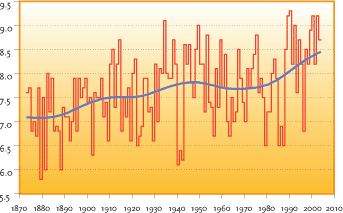
Source: The Meteorological Institute and The National Environmental Research Institute
The annual mean temperature, Denmark, 1873-2004
1 INTRODUCTION
1.1 Systematicobservations
1.2 Data availability
2 METEOROLOGICAL AND ATMOSPHERIC OBSERVATIONS
2.1 Contributing to GCOS
2.2 GCOS Surface Network / GSN Stations
2.3 GCOS Upper Air Network / GUAN Stations
2.4 GCOS Global Atmospheric Watch / GAW Stations
2.5 Other national meteorological and atmospheric observations:
2.5.1 Climatological/meteorological surface stations
2.5.2 Precipitation observation networks (stations and radar)
2.5.3 Surface radiation and sunshine observation network
2.5.4 Solar ultraviolet (UV) radiation and stratospheric ozone stations
2.5.5 Upper air strata measurements - Radio sounding observations
2.5.6 Ice observations
2.5.7 Climatological data sets
2.5.8 Air quality monitoring
3 OCEANOGRAPHIC OBSERVATIONS9
3.1 Contributing to GCOS
3.2 Voluntary observing ships/VOS
3.3 Tide gauge/GLOSS
3.4 Automatic shipboard aerological programme (ASAP)
3.5 Other national oceanographic and maritime observations
3.5.1 Sea temperatures
3.5.2 National tide gauge network
3.5.3 Hydrographic and marine surveys
5 SPACE-BASED OBSERVATIONS
5.1 ESA and EUMETSAT satellites and programmes
5.2 GPS data from the Ørsted, SAC-C and CHAMP satellites
6 ACTIVITIES IN DEVELOPING COUNTRIES RELATING TO OBSERVATIONS
1 Introduction
This report has been prepared to give a status on the Danish contribution to the systematic climate observations in the Global Climate Observing System (GCOS). The report is part of the Fourth National Communication to the Conference of the Parties under the United Nations Framework Convention on Climate Change (UNFCCC).
Climate research and the generation of climate-related observations are carried out by various government departments in order for them to meet their responsibilities. Currently, no national plan exists for the whole area of climate research and observations.
1.1 SYSTEMATIC OBSERVATIONS
A number of agencies in Denmark engage in the systematic observation of elements of the climate system. Invariably the capture, quality control and archiving of such data are designed to meet the integrated needs of these agencies, deriving from their overall missions.
Typically the drivers for long-term systematic observation of environmental or ecological characteristics arise from an operational, regulatory or research need. Examples of the former are to be found in the capture of meteorological data for predictive and statistical services by the Danish Meteorological Institute (DMI). The resulting observation programmes tend to be long term, but the resulting individual data may be seen as perishable and focus might not always be on maintaining stability and reliability in the records.
The general need for systematic and reliable time series is increasingly being understood in the scientific community and incorporated in the collection and data processing procedures.
1.2 DATA AVAILABILITY
In this report relevant climate observations for Denmark, Greenland and the Faroe Islands will be described. In general the data are available from the institutions operating the observing station / collecting the data, but many can also be found on the web, for instance www.dmi.dk. Where data such as contributions to GCOS are submitted to the appropriate data centres, they are also available from these centres.
Additionally, all meteorological data and products that are produced by WMO Members (national meteorological services) to the WMO programmes such as the WWW are available under the terms of WMO Resolution 40 (WMO policy and practice for the exchange of meteorological and related data and products including guidelines on relationships in commercial meteorological activities). Such data are freely available without charge (i.e. at no other cost than the cost of reproduction and delivery, without charge for the data and products themselves and with no condition on their use)
Similarly hydrological data and products are covered under WMO Resolution 25. Further the IOC are expected to adopt a data policy which provides for free and open access to data that are collected, produced or exchanged as part of oceanographic programmes conducted in association with the IOC.
2 Meteorological and atmospheric observations
2.1 CONTRIBUTING TO GCOS
Denmark participates fully in the GCOS Surface Network (GSN) and the GCOS Upper Air Network (GUAN), and in the Global Ozone Observing System (GO3OS) as part of the Global Atmospheric Watch (GAW).
TABLE H-1. DANISH PARTICIPATION IN THE GLOBAL ATMOSPHERIC OBSERVING SYSTEM
| GSN | GUAN | GAW¹ | |
| How many stations are the responsibility of the Party? | 7 | 1 | 4 |
| How many of these are operating now? | 7 | 1 | 4 |
| How many are currently in operation in accordance with the GCOS standard? | 7 | 1 | 4 |
| How many are expected to be in operation in 2005? | 7 | 1 | 4 |
| How many currently provide data to international data centres? | 7 | 1 | 4 |
1 Denmark participates in GAW's GO3OS
2.2 GCOS SURFACE NETWORK / GSN STATIONS
The seven designated GSN stations in Denmark, Greenland and on the Faroe Islands are all run by DMI and include:
- Greenland: Upernarvik, Nuuk, Danmarkshavn, Tasiilaq, Prins Christian Sund;
- The Faroe Islands; Tórshavn
- Denmark: Copenhagen.
All of these stations currently meet the GCOS standard for surface observation.
2.3 GCOS UPPER AIR NETWORK / GUAN STATIONS
Only one GUAN station is designated for Denmark, Greenland and the Faroe Islands and it is situated in Narsarsuaq, Greenland. The station is run by DMI and is operated in accordance with the GCOS standard. A survey of the station's 2004 results shows that 88% of the soundings reached a pressure of 30 hPa.
2.4 GCOS GLOBAL ATMOSPHERIC WATCH / GAW STATIONS
As part of the GAW programme, Denmark contributes to the Global Ozone Observing System (GO3OS) with three stations in Greenland and one in Denmark. The stations in Kangerlussuaq (Greenland) and Copenhagen (Denmark) are equipped with Brewer spectrometers, the station in Pituffik (Greenland) is equipped with a Dobson and a SAOZ spectrometer, and the station in Illoqqortoormiut (Greenland) is equipped with a SAOZ spectrometer. The spectrometer in Illoqqortoormiut is operated by Service d'Aeronomie (France) in cooperation with DMI while all other spectrometers are operated by DMI. All data are available from DMI. The stations in Greenland are primary and secondary stations in the Network for the Detection of Stratospheric Change (NDSC) that is supported by the International Ozone Commission, the UNEP and the WMO.
2.5 OTHER NATIONAL METEOROLOGICAL AND ATMOSPHERIC OBSERVATIONS:
2.5.1 Climatological/meteorological surface stations
DMI operates and receives data from a network of approximately 100 automatic meteorological stations in Denmark, Greenland and on the Faroe Islands. Measurements are made in accordance with the WMO recommendations.
FIGURE H-1: DMI'S NETWORK OF WEATHER STATIONS IN DENMARK
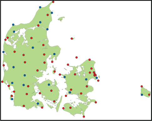
As of 2001 a special dedicated network of (manual) stations for climatological observations has been discontinued, due to the convergence between the different network technologies. The objectives behind this decision are to eliminate human errors, to benefit from potential savings due to this rationalisation, and to reach a higher observation frequency. Climatological data are now obtained from the automatic network described above.
FIGURE H-2: DMI'S NETWORK OF WEATHER STATIONS IN GREENLAND
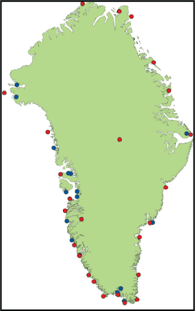
Climatological data are collected to define the climate in Denmark, Greenland and on the Faroe Islands and to create a national database for a wide range of enquiries and research activities. Climatological work mostly consists of preparing annual and monthly statistics, including calculation of averages, percentiles and standard deviations.
FIGURE H-3: DMI’S NETWORK OF WEATHER STATIONS ON THE FAROE ISLANDS
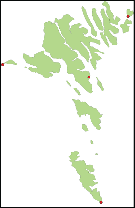
Substantial recorded data are needed to establish reliable averages and trends. In 2004 the daily inflow of data from Denmark, Greenland and the Faroe Islands was 100,000 observations, and the central database at DMI currently contains more than 300,000,000 observations. Some of the recorded data are from as early as 1872.
A monthly summary is prepared for the three stations in Denmark, one on the Faroe Islands and eight in Greenland using the CLIMAT format. These data are routinely submitted via the GTS.
2.5.2 Precipitation observation networks (stations and radar)
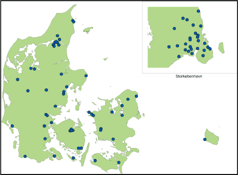
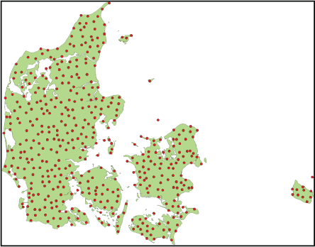
For national purposes, more data concerning precipitation is needed than can be provided from the overall surface climatological and meteorological network described above. In Denmark the precipitation observation network consists of approximately 575 stations. Roughly 100 of these provide data on precipitation intensity on an ongoing basis. They are jointly operated by DMI and The Water Pollution Committee of the Society of Danish Engineers (Spildevandskomitéen - SVK). The remaining 500 stations collect daily values of precipitation, and data from approximately 100 of these are electronically transmitted to DMI on a daily basis.
FIGRUE H-4: DMI’S NETWORK OF AUTOMATIC PRECIPITATION INTENSITY STATIONS (DETAILED FOR COPENHAGEN)
On the Faroe Islands a network of 22 precipitation station observe daily precipitation.
FIGURE H-5: DMI’S NETWORK OF MANUAL PRECIPITATION STATIONS
Information on precipitation can also be obtained from weather radar data. In Denmark, DMI runs a network of three weather radars which provides 100% coverage of Danish land areas and coastal marine areas. The network's geographical coverage is unsurpassed, and hence provides detailed information about precipitation on national and local scales. By calibrating radar data against point measurements of precipitation the latest scientific results show a high absolute accuracy. The present radar network has a data frequency of 6 pictures per hour, and a spatial resolution of 2 km x 2 km.
2.5.3 Surface radiation and sunshine observation network
DMI runs a network of 23 sunshine observation stations in Denmark, six in Greenland, and one on the Faroe Islands.
Radiation is measured as 10- minute mean values of global radiation at the DMI operated stations and the number of hours of sunshine is then calculated based on the global radiation.
2.5.4 Solar ultraviolet (UV) radiation and stratospheric ozone stations
Solar Ultraviolet (UV) radiation at different wavelengths is measured by DMI at two stations in Greenland, namely Pittuffik and Kangerlussuaq. In addition to the GO3OS described above, DMI performs weekly ozone soundings at Illoqqortoormiut as well as sporadic ozone soundings at Pituffik during the winter months.
2.5.5 Upper air strata measurements - Radio sounding observations
DMI runs radio sounding stations at the following seven locations: Copenhagen (Denmark), Tórshavn (the Faroe Islands), Danmarkshavn, Illoqqortoormiit, Tasiilaq, Narsarsuaq and Aasiaat (Greenland). Two soundings are made every day at these stations.
A monthly summary (CLIMAT TEMP) from all seven radio sounding stations is prepared and transmitted routinely on the GTS.
2.5.6 Ice observations
DMI is responsible for the systematic surveillance of sea ice conditions in the Greenland waters. Observations concerning ice conditions have been collected for approximately 125 years and an extensive volume of data is available in a graphic format as monthly summaries, ice maps etc.
Since 1959 special emphasis has been on the waters south of Cape Farewell (the southern tip of Greenland) in order to improve navigation safety in what is an important navigation area. Ice maps containing detailed information on the relevant ice conditions are prepared several times a week. The most recent maps are available in vector graphic format.
Since 2000 weekly summaries of the ice conditions for all Greenland waters have been prepared. These summaries, which are based on satellite data, are generated semi-automatically and are primarily intended for climatological analyses as the energy radiation from the sea is highly dependent on whether it is covered with ice or not.
2.5.7 Climatological data sets
Over the years, DMI has established a number of very long climatological series with differing periods of information representing Denmark, Greenland and the Faroe Islands.
The long daily time series include: precipitation, temperature, atmospheric pressure and cloud cover for a number of Danish locations, 1874-2004 as well as precipitation and temperatures for two Greenland Stations 1874-2004 (DMI Technical Report no. 05-04).
The long monthly time series include: temperatures, precipitation, atmospheric pressure, cloud cover and snow for stations in Denmark, Greenland and on the Faroe Islands (DMI Technical Report 05-05).
The long annual time series include: temperature for a number of stations in Denmark, Greenland and on the Faroe Islands (1873-2004), as well as temperatures, precipitation, hours of sunshine and cloud cover given as national averages for Denmark (DMI Technical Report 05-06).
2.5.8 Air quality monitoring
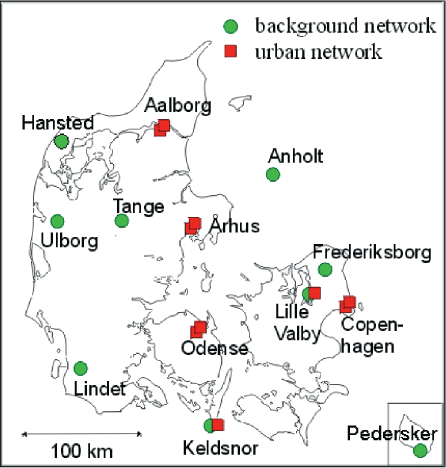
Air pollution is automatically monitored in both urban and rural areas across Denmark. This monitoring network is operated by NERI and measures a wide range of pollutants:
- Nitrogen monoxide (NO)
- Nitrogen dioxides (NO2)
- Ozone (O3)
- Sulphur dioxide (SO2)
- Total Suspended Particulate matter, TSP (PM10)
- The chemical composition of particles (sulphate, sea salt, heavy metals etc.)
- Nitrogen compounds (ammonia (gas), particulate ammonium, sum of nitric acid and particulate nitrate)
- Benzene, toluene and xylene (BTX)
- Carbon monoxide (CO)
Furthermore, at a number of NERI stations deposition of air pollution via precipitation is monitored. Figure 6 shows the types and distribution of air quality monitoring stations across Denmark, and in Table 2 the measurements taken at the different stations are listed. Current monitoring data from air monitoring stations, reports from previous quarters as well as development trends for the air quality in Denmark can be found on NERI's website (www.dmu.dk).
Prognoses of air pollution in Denmark for the next three days as well as detailed prognoses for Copenhagen and Ålborg can also be found here.
In addition to the ozone measurements mentioned above, DMI operates an ozone monitoring station at Jægersborg in a suburban environment near Copenhagen as well as a station in Store Jyndevad in a rural area in the south of Jutland. Real-time hourly data are presented on DMI's website (http://www.dmi.dk). Data with a time resolution of 10 minutes are also available from DMI.
FIGURE H-6: AIR QUALITY MONITORING STATIONS IN DENMARK
3 Oceanographic observations
3.1 CONTRIBUTING TO GCOS
Oceanographic observations for GCOS are based on the GOOS climate module for the open ocean, which comprises the following programmes: drifting and moored buoy programmes managed by the DBCP (Data Buoy Co-operation Panel), the Ship of Opportunity Programme (SOOP), the Argo array of profiling floats, the Global Sea Level Observing System (GLOSS), the Voluntary Observing Ships Programme (VOS) and the Automated Shipboard Aerological Programme (ASAP).
Denmark participates in the VOS, GLOSS and ASAP programmes as summarised in table 3 below.
3.2 VOLUNTARY OBSERVING SHIPS/VOS
VOS is an international scheme developed approximately 150 years ago by which special ocean-going ships are recruited to collect and report meteorological observations. Contributions made by VOS ships to the Global Observing System (GOS) of the World Weather Watch (WWW) are extremely important. Moreover, these observations increasingly contribute to global climate studies through the VOS Climate Project VOSClim. VOS observations are disseminated via GTS and are archived by many national meteorological services.
TABLE H-2: MEASUREMENTS TAKEN AT THE DIFFERENT STATIONS
TABLE H-3: PARTICIPATION IN THE GLOBAL OCEANOGRAPHIC OBSERVATION SYSTEMS
Click here to see Table H-2 and Table H-3
At the end of 2004, the Danish fleet of voluntary observing ships consisted of 47 ships. DMI has the operational and technical responsibility for the observations, which are reported from the ships every third hour.
3.3 TIDE GAUGE/GLOSS
GLOSS is an international programme coordinated by IOC for the establishment of global and regional advanced sea level networks to be used in climate research, oceanographic research as well as research concerning the sea level in coastal areas. The main component of GLOSS is the Global Core Network (GCN) of 287 sea level stations around the world that monitor long-term climate change and oceanographic sea level variations. There is a GLOSS station in Tórshavn (Faroe Islands), which is operated by DMI. The relevant mean values from the stations are transmitted to the Permanent Service for Mean Sea Level (PSMSL) hosted by the Proudman Oceanographic Laboratory in the UK.
The PSMSL, established in 1933, is a global database containing information on long-term sea level variations based on tide gauges. Information on monthly and annual mean sea levels is reported to PMSLS from 15 stations in Denmark and one on the Faroe Islands.
3.4 AUTOMATIC SHIPBOARD AEROLOGICAL PROGRAMME (ASAP)
The ASAP in its present form began in the mid1980s. The programme's objective is to record profile data from the upper air strata in ocean areas using automated sounding systems carried on board merchant ships plying regular ocean routes. Several national meteorological services operate ASAP units and the collected data are made available in real time via GTS. ASAP data are archived alongside other radio sounding data by many national meteorological services. ASAP is an important contribution to both the WWW and GCOS. Today most of the soundings are from the North Atlantic and north-west Pacific, but the programme is expanding to other ocean basins through a new, co-operative World-wide Recurring ASAP Project (WRAP).
Denmark operates two ASAP units mounted on ships plying fixed routes from Denmark to Greenland.
The European meteorological cooperation EUMETNET started a special E-ASAP programme in December 2000. The programme aims at joint operation of the ASAP programmes under the European meteorological institutes.
3.5 OTHER NATIONAL OCEANOGRAPHIC AND MARITIME OBSERVATIONS
3.5.1 Sea temperatures
Denmark has a network for the collection of sea temperatures at 13 coastal stations around Denmark. The stations are operated by DMI, the Royal Danish Administration for Navigation and Hydrography, the Danish Coastal Authority, and local authorities respectively. Data are available from each of the responsible bodies. Furthermore, sea surface temperatures are monitored using satellites, and DMI prepares daily maps for the North Sea and Baltic Sea areas.
3.5.2 National tide gauge network
In Denmark an extensive national network of tide gauges are operated jointly by DMI, the Royal Danish Administration for Navigation and Hydrography, local authorities and the Danish Coastal Authority. The network consists of 81 automatic stations.
In Greenland a tide gauge station is operated by National Survey and Cadastre (KMS). On the Faroe Islands one station is operated in Tórshavn by DMI. Data are available from the responsible bodies.
3.5.3 Hydrographic and marine surveys
The National Environmental Research Institute has the overall responsibility for surveillance of the Danish waters. Surveillance of fjords and coastal waters is carried our by the regional authorities approximately 24-47 times a year, while NERI is responsible for mapping the open waters on five expeditions per year where the objective is to:
- determine the current situation in open Danish waters
- trace the impact of land-based discharges of pollutants
- establish reference data for local monitoring in coastal areas
- secure continued time series for trend monitoring
All of the surveys are part of the Danish nationwide monitoring programme NOVANA, and many of the surveys are part of the HELCOM monitoring programme for the Baltic Sea area as well as the OSPARCOM monitoring programme for Kattegat, Skagerrak and the North Sea. All marine NOVANA data (regional and state) are collected annually in the national marine database, MADS, by NERI, and can be downloaded from the internet at: http://mads.dmu.dk.
The Danish Institute for Fisheries Research carries out yearly surveys in Danish waters, primarily in the North Sea and the Baltic Sea. Relevant oceanographic parameters are measured and recorded for these areas.
Furthermore, DMI is involved in the following projects:
- Measurements of water transports across the Greenland-Scotland Ridge
During the Nordic WOCE proprogramme (1993-97) observations of the water transport across the Greenland-Scotland Ridge were initiated and the measurements have been continued after the closing of the Nordic WOCE programme. The goal of the observation campaign was to put reliable numbers on the volume transports of the various current components flowing in and out of the Nordic Seas, and especially to investigate possible seasonal and inter-annual variability, which might reflect changes in the global thermohaline circulation.
- Monitoring of the oceanographic conditions along West Greenland
As a member to the North Atlantic Fisheries Organisation (NAFO), Denmark/Greenland has the responsibility for monitoring the physical oceanographic conditions along the west coast of Greenland. The formal responsibility for performing these measurements is placed at the Greenland Nature Institute, Nuuk. Since 1998 the Institute has allocated the work by contract to the Danish Meteorological Institute. The temperature and salinity is measured at standard stations along the Greenland west coast so as to obtain knowledge about the marine climate in the area. The marine climate has a great impact on the reproduction and survival of the fish species living in the area – some of which are close to extinction. These data are therefore of great importance when assessing conditions concerning the fisheries.
- Monitoring of the oceanographic conditions around the Faroe Islands
Four times a year the Fisheries Laboratory in Tórshavn monitors the oceanographic conditions around the Faroe Islands in four standard sections so as to study the water mass composition and its variability in the area.
4 Terrestrial observations
Monitoring snow cover, sea ice and surface radiation is a natural part of DMI's activities. DMI does not carry out any additional terrestrial observations that can be related to climate change. However, some climate-related research includes monitoring the effect of climate terrestrial conditions.
5 Space-based observations
Denmark contributes to space-based observations through its membership of the European Space Agency ESA (a partnership of 15 European Member States, with Canada affiliated), EUMETSAT (the European Organisation for the Exploitation of Meteorological Satellites, a partnership of 18 European Member States and eight cooperating States), and by the use of small national satellites. This report, that focuses on Denmark's specific needs and efforts, does not as such include detailed information on platforms and sensors. The Danish strategy for earth observations (EO) is largely delivered through participation in international programmes and to some extent through national programmes such as the Ørsted satellite.
The Danish space activities are not coordinated by one central institution. The Ministry of Science, Technology and Innovation represents Denmark in ESA, whereas the responsibility for the meteorological observation aspects (EUMETSAT) lies with the Ministry of Transport and Energy.
The actual activities are carried out by several organisations, such as DMI, the Technical University of Denmark, the Danish Space Research Institute and of course private industry.
5.1 ESA AND EUMETSAT SATELLITES AND PROGRAMMES
The ESA platforms that are either currently in operation or are due for launch before the end of 2005, and the projects in which Denmark participates, include:
- ERS-2. Launched in 1995. Follow up to ERS-1 by examining the Earth by radar, microwaves and infrared radiation. Carries an additional instrument to observe the ozone hole.
- ENVISAT. Launched in 2002. European environmental satellite to succeed ERS satellites with advanced versions of the instruments used in ERS-2 and several important new instruments.
- MSG-1 (ESA and EUMETSAT) launched in 2002. MSG2 launch planned for June 2005. The Meteosat Second Generation geostationary satellites will provide far more precise weather information than the current Meteosat, which has operated over the Equator since 1977.
- METOP-1 (ESA and EUMETSAT) with advanced instruments for measuring atmospheric conditions etc. is expected to be launched in the course of 2006. While Meteosat and MSG observe the weather conditions in Europe and Africa from a geostationary position above the Equator, METOP will have a significantly lower polar orbit and will therefore cover the Artic and Antarctic areas.
DMI represents Denmark in EUMETSAT, which currently has the following programmes:
- MTP (Meteosat Transition Programme). Operation of Meteosat-7, -6 (standby), -5 (Indian Ocean) in geostationary orbit.
- MSG (Meteosat Second Generation). Future operation of MSG-1, -2, and –3 in geostationary orbit.
- EPS (European Polar System). Future operation of METOP-1 (launch planned for 2006), -2 and –3 in polar orbit.
As part of its distributed application ground segment EUMETSAT has a network of Satellite Application Facilities (SAFs) that are specialised development and processing centres (see http://www.eumetsat.de for details). These centres utilise the specific expertise available at the national meteorological institutes in EUMETSAT's Member States, and complement EUMETSAT's own production of standard meteorological products derived from satellite data. Seven SAF projects are undergoing development, focusing on the following applications:
- SAF for support for nowcasting and very short range forecasting
- Ocean and sea ice SAF -Ozone monitoring SAF
- Numerical Weather Prediction SAF
- Climate monitoring SAF
- GRAS meteorology SAF
- Land surface analysis SAF
A number of these are relevant regarding of GCOS monitoring. DMI hosts the GRAS meteorology SAF and also contributes to the ocean and sea ice SAF as well as the ozone monitoring SAF.
5.2 GPS DATA FROM THE ØRSTED, SAC-C AND CHAMP SATELLITES
Measurement of the GPS radio occultations is a new and very promising technique for both numerical weather prediction and for monitoring and identifying climate change processes. This was first demonstrated by the American GPS/MET mission. The research satellites Ørsted, SAC-C and CHAMP are all equipped with high precision GPS receivers that are required to perform this kind of profile measurements in the atmosphere. GPS data from the Danish Ørsted satellite, launched in 1999, has been used in the EU project CLIMAP (CLImate and environment Monitoring with GPS based Atmospheric Profiling) to study the impact on numerical weather prediction. As these data need no calibration, they may prove very valuable for climate monitoring purposes, as several data sets and model forecasts can be combined.
The primary objective of the CLIMAP project was to demonstrate the value of the GPS technique in relation to Numerical Weather Predictions (NWP). The project includes data from GPS reception at ground level as well as from Low Earth Orbiting (LEO) satellites. An end-to-end chain for processing satellite-based GPS radio occultation data was developed: From GPS signal reception to assimilation into the NWP models. The chain included operational reception of tracking data from the Ørsted satellite with associated level-0 processing and archiving (has been developed and is operated by the Danish company TERMA A/ S and DMI). This concept will also be used by DMI in connection with the new GPS data received from the German CHAMP and the Argentine SACC satellite.
6 Activities in developing countries relating to observations
From 1997 to 2004 DMI participated in a project in cooperation with the Meteorological Services Department of Ghana (MSD). The objective of the project was primarily to re-establish a meteorological observation network in Ghana and thereby ensure the collection of data. At the same time, the project aimed at improving communication and utilisation of the collected data. At the time of finalisation of the project, MSD had a successful observation network of approximately 300 stations that record the basic meteorological parameters.
The DMI/Danish Climate Centre coordinated the project Application of seasonal climate forecasts for improved management of crops in western Africa. The objective was to explore the possibilities of adjusting crop management practice for a selected agricultural crop (groundnuts) in Ghana, western Africa, using the best available seasonal climate forecasts. The project was funded by the Danish Council for Development Research (Rådet for Ulandsforskning -RUF).
7 List of acronyms
| ASAP | Automated Shipboard Aerological Programme |
| CHAMP | Challenging Mini-satellite Payload |
| CLIMAT | Climate message encoded for the WMO network |
| CLIMAT-TEMP | CLIMAT from upper air soundings |
| CLIMAP | Climate and environment Monitoring with GPS based Atmospheric Sounding |
| DIAS | Danish Institute of Agricultural Science |
| DMI | Danish Meteorological Institute |
| DBCP | Data Buoy Cooperation Panel |
| EO | Earth Observations |
| ERS | European Research Satellite |
| ESA | European Space Agency |
| EUMETSAT | European Organization for the Exploitation of Meteorological Satellites |
| GAW | Global Atmospheric Watch of WMO |
| GCN | Global Core Network (of GLOSS) |
| GCOS | Global Climate Observing System |
| GLOSS | Global Sea Level Observing System |
| GNSS | Global Navigation Satellite System |
| GO3OS | Global Ozone Observing System |
| GOOS | Global Ocean Observing System |
| GPS | Global Positioning System |
| GPS/MET | GPS Meteorology |
| GRAS | GNNS Receiver for Atmospheric sounding |
| GSN | GCOS Surface Network |
| GTS | Global Telecommunications System |
| GUAN | GCOS Upper Air Network |
| HELCOM | Helsinki Commission - Baltic Marine Environment Protection Commission |
| IOC | Intergovernmental Oceanographic Commission (of UNESCO) |
| LEO | Low Earth Orbiting |
| MSD | Meteorological Services Department (Ghana) |
| NDSC | Network for the Detection of Stratospheric Change |
| NERI | National Environmental Research Institute |
| NOVA2003 | Danish Aquatic Environment monitoring and Assessment Programme |
| OSPARCOM | Oslo and Paris Commissions on the North East Atlantic Sea |
| SAC-C | Satélite de Aplicaciones Científicas-C |
| SAF | Satelite application facility |
| SFC | Surface (Drifters) |
| SOOP | Ship of Opportunity Programme |
| SVK | The Water Pollution Committee of the Society of Danish Engineers |
| UV | Ultraviolet VOS Voluntary Observing Ships |
| WMO | World Meteorological Organization |
| WRAP | World-wide Recurring ASAP Project |
| WWW | World Weather Watch (of WMO) |
Version 1.0 December 2005, © Danish Environmental Protection Agency