|
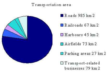
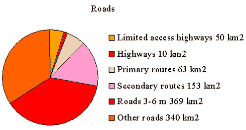
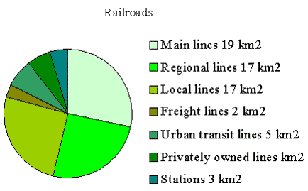
Arealanvendelse til transportformål i Danmark Summary and conclusionsA calculation of transportation-related land areas quickly becomes a task of making limitations. Even though the term "areas used for transportation" sounds immediately easily understandable and well delimited, it still leaves us with the possibility for various nuances of interpretation. In this study, we have examined six categories: roads, railroads, ports, airfields, parking areas and areas for transport-related businesses. This selection of categories is already a delimitation. In general, the entire area of roads, harbours, airfields, etc. are included in the calculation of transport-related area. More emphasis is placed on an area being reserved for transport purposes and thereby not available for other uses, than on whether or not the area is asphalted. As an example, the entire boundary of an airfield is considered part of the area used for air transport, even though most of the air field is open field. In general, we have calculated transportation-related areas on the basis of publicly accessible areas. Privately owned areas are also included if they are publicly accessible. We thus calculated private roads and railroads as well as parking areas near shops and businesses, as long as they are publicly accessible. Excluded on the same grounds, however, are all military zones as well as privately closed areas such as private marinas. The real challenge consists in separating the aforementioned areas of the six categories from the surrounding terrain, and from each other. By way of introduction, we will attempt to delimit each of the six categories. RoadsRoads are usually divided by either administrative classes (limited access highways, highways, etc.) or according to type of ownership (state roads, municipal roads, etc.). The sum of each group ought to be equivalent to Denmark’s total road network. This study applies a broad interpretation of the concept "roads", whereby all publicly accessible roads are included, regardless of size. The criteria applied are those used in the "Danish Address and Road Database" (Danish abbreviation: DAV) which includes all roads, regardless of size, on which there can be found two or more addresses. The road area extends all the way to the property. This entails that roads which are normally calculated as field- forestry- or access roads are also included, as long as they have at least two addresses. The breadth of the road includes bicycle paths, pavements, road edges and ditches. Where neighbour areas are found, this is calculated as a difference in land registry RailroadsRailroad lines in Denmark are well-defined. The rail lines are categorized as main lines, regional lines, local lines, freight lines, etc. In area terms, the problem is to select from among them, and the tourist and preserved old-time railway lines must also be included. The next task is to convert the aforementioned categories into track width. Besides the tracks themselves, the calculation must include stations, freight terminals, garages and depots and shunting yards. HarboursDenmark has many harbours if one includes all the small docking areas. This study has included the public and private transport and commercial harbours. Not included are harbours exclusively used for recreational sailing or exclusively for military purposes. Included, however, are publicly accessibly private harbours, and harbours at refineries and power stations. Air fieldsIn this study, air fields are defined as publicly accessible traffic air fields. In determining the size of air fields, we apply the Danish Ministry of Environment’s specifications for environmental certification. Excluded, however, are airfields on water areas (BL3-36)2. Purely military air fields are also excluded, as are airfields devoted exclusively to recreational purposes such as glider facilities. Parking areasThis category is defined as marked, publicly accessible, parking stalls. Also included are marked parking stalls in connection with for example, shops, businesses and public institutions, even though these areas may be restricted to the employees or customers. Where it is possible to differentiate, publicly accessible covered parking lots are also included as long as this is the only utilization of the area, and that it is simultaneously restricted from other usage. That is, areas used as parking garages are included with their land area (without multiplying by the number of storeys), while underground parking is not included, as it does not prevent alternative utilization of the surface area. Transportation-related businessesThis category includes private businesses whose main land usage is transport-related. These businesses include primarily the purchase, sale, maintenance and rental of automobiles and other means of transport, as well as moving, delivery and freight forwarding companies. Also included are workshops and service stations. The firms occupied within the transport sector but without essential transport character at the address, e.g., travel bureaus or the accounting offices of car leasing firms on the pedestrian street, are as much as possible not included, as they do not distinguish themselves from the other office areas. Overlap between categoriesA problem in calculating different categories of traffic area with the help of different methods is the obvious risk of including the same area in two or more categories. An example here are the parking spaces placed along streets and roads. As long the road area is calculated by multiplying length times breadth, these parking areas will normally be included. At the same time, if the parking area is calculated, by multiplying the municipalities’ information as to the number of available parking places by an average area, the same areas will become included twice. It is difficult, however, to eliminate this problem. It would require that every type of area be identified and measured such that the sum of the categories was equal to the total area surveyed, and that the all areas mutually excluded each other. The Orthophoto solutionAir photo analysis has been considered as a method in this context. It makes it possible to ensure that the requirements for total coverage and mutual exclusion of categories are fulfilled simultaneously. The method has two problems, however. It can only include categories, which physically manifest themselves on the surface and are therefore visible in photos. This excludes, for example, a distinction between different commercial categories. Further it would be very resource demanding. An estimated 500 working hours would be required to analyse the air photos for the entire area of Denmark General tendencies in the development of transport-related land area over timeA total historical calculation of the transport-related land area is difficult. In the best case it is very imprecise and in the worse cases can be misleading. However, there exist certain related parameters which can be calculated objectively, e.g., the area of the urban zone according to the zoning regulations, the number of houses or vehicles, or quite simply the number of inhabitants. It is extremely speculative whether such parameters are directly proportional to the traffic area, and such comparisons have not been attempted in this study. It is possible, however, to elucidate the development in land usage for certain of the categories. It seems that the railroads in Denmark have a well documented history as concerns area. It is a general assumption that Denmark’s total transport-related land use area has been continually increasing. An exception, however, are, e.g. the parking areas in central Copenhagen, where there has been a policy to reduce the number of parking spaces. It must be assumed that the total transport-related land area in Denmark will continue to grow, though with a stagnating tendency. An initial estimate of Denmark’s transportation areaIn this section, a total estimate of transport-related land use is provided on the basis of all the estimates and assumptions carried out in connection with this study. It should not be considered as the result of the study. The individual figures thus stem from each of the following chapters. It should be noted that some figures are considered more uncertain than the others. The figures for the railroads and airfields are reasonably certain, the figures for roads and harbours somewhat uncertain, while the estimates for parking area and transport-related businesses are extremely uncertain. The main result of the present study is, in accordance with the assignment, to scan the possibilities of estimating the area used for transportation-related purposes in Denmark. The conclusion is that it is possible, though not with the desirable accuracy, given today’s data-availability. Suggestions for further studies are to try sharpening the definitions of the individual categories of areas used for transportation-related purposes. Preferably these should be defined based on quantitative parameters that can be easily monitored. Total land area used for transportation purposes in Denmark:
Sub-Categories:
2 "Vejledning fra Miljøstyrelsen" Nr. 5 1994 - Støj fra flyvepladser (Danish EPA guidelines, noise from air fields [Tilbage]
|