Ship emissions and air pollution in Denmark
Summary and conclusions
Background and objectives
Ship traffic in the Danish marine waters is considered to be important for air quality in Danish cities and in Denmark in general. Previously, the Danish National Environmental Research Institute at Aarhus University (NERI, in Danish Danmarks Miljøundersøgelser) has provided certain estimates for the significance of shipping to air pollution (e.g. Olesen et al., 2008). However, these previous estimates were subject to a high degree of uncertainty. They were based on emission inventories with a low geographical resolution (50 km x 50 km). Furthermore, they were based on simplifying assumptions, which do not necessarily reflect the actual patterns of ship traffic.
However, since 2006 the so-called Automatic Identification System (AIS) has registered ship activities in Danish marine waters. All ships larger than 300 GT (Gross Tonnage) are required to carry a transponder, which transmits information on the ship’s identity and position to land-based receiving stations. This information makes it possible to map ship emissions in much greater detail than previously feasible. This opportunity has now been utilised to create a new emission inventory for ships in the Danish marine waters.
The new AIS-based inventory of ship emissions has been combined with other necessary data and used as basis for new model calculations of air quality in Denmark. A main objective of this work is to assess the contribution from ships to concentration levels of various pollutants. For the modelling of concentrations, a new version of the air pollution model DEHM (Danish Eulerian Hemispheric Model) has been applied - a version with a higher geographical resolution than the previous version.
The International Maritime Organisation (IMO) has adopted new regulations in order to reduce pollution from ships with sulphur dioxide (SO2) and nitrogen oxides (NOX) in the period until 2020. It is also the objective of this work to investigate the effect of this regulation on air quality in Denmark. This is done through scenario calculations for air quality for 2020 based on expected emission reductions.
Also for land-based sources of SO2, NOx and particles, emission reductions are envisaged before 2020. The scenario calculation for 2020 takes account of these reductions.
A minor component of the current study concerns the contribution from ships at port to local air pollution in the ports of Copenhagen and Aarhus.
The study
The study has been carried out by NERI at Aarhus University. As one of the main parts of the study a new, improved inventory of ship emissions in the Danish marine waters has been established. Both new (NERI) and old (EMEP, 2008) emission inventories have been applied for model calculations of air quality in Denmark, thus allowing an assessment of the effect of the revised inventory.
Furthermore, scenario calculations for 2011 and 2020 have been carried out, in order to evaluate the effect of the IMO regulations. The scenario calculations have been based on expected reductions in ship emissions and an estimate for land-based emissions in 2020.
Finally, the contribution to local air pollution from ships at ports has been assessed in various ways, based on updates of previous studies.
Main conclusions
Concerning emissions:
- One of the main results of the project is that a new, improved emission inventory for national and international ship emissions in Danish marine waters has been established. The inventory has a spatial resolution of 1 x 1 km. Previous inventories from the European Monitoring programme EMEP applied a grid size of 50 x 50 km. A comparison between the measured concentrations and model results based on the old (EMEP) inventory and the new (NERI) inventory shows that the new inventory is a considerable improvement.
- Between 2007 and 2020 an emission reduction as large as 91% is envisaged in the marine waters around Denmark, in respect to sulphur dioxide from ship traffic - despite an increase of traffic. This is due to the IMO regulations.
- Within the same period a marginal increase is expected in total emissions of nitrogen oxides (NOX) from ship traffic, namely by 2% from 2007 to 2020. Without stricter emission standards the increase would have corresponded to the increase in fuel consumption, i.e. 15%. The IMO requirements imply large NOX reductions for new ships from 2016. As a consequence, the ship fleet will gradually experience a reduction in its average NOX emission factor from 2016 onwards; this development will continue after 2020.
Concerning concentrations:
- Since 1990, SO2 emissions from land-based sources have been substantially reduced, and in the years to come a continued large reduction from ship traffic is expected, along with an expected reduction for land-based sources. Based on scenario calculations the SO2 concentration level as an average for Denmark will decrease considerably in the period up to 2020, so in 2020 it will reach a level of 0.3 μg/m³, which is only 6% of what it was in 1990, and corresponds to 1.5% of the EU limit values. In 2007 around 33% of the SO2 concentration level in Denmark was due to ship emissions, this number will be reduced to about 11% in 2020.
- The concentration of nitrogen dioxide (NO2) in urban background air in Copenhagen is expected to be reduced from 16 to 9 μg/m³ in the period up to 2020. The reduction is due to expected reductions in NOX emissions from land-based sources. For ship traffic, however, the contribution is essentially unchanged, because increase in ship traffic and stricter emission requirements balance each other. For Denmark as a whole the NO2 concentration level is considerably lower than in Copenhagen, and it will decrease from 5.5 to around 3.5 μg/m³ from 2007 up to 2020. Presently, as an average for Denmark, 21% of NO2 can be attributed to ship traffic, but the relative share from ships will increase in the years up to 2020 due to reductions for the land-based sources.
- A considerable amount of fine particles (PM2.5) is of unknown origin. Internationally, this is recognised as being state-of-the-art. The fraction that can be explained and modelled is here designated mPM2.5 (modelled PM2.5, see the section Concentrations of particles here in the summary for further explanation). Around 1 μg/m³ of the mPM2.5 level can be attributed to ships, both in Copenhagen and generally in Denmark. Calculations point to a slight decrease by approximately 0.2 μg/m³ during the period to 2020. If one wishes to express the ship contribution in terms of percent, the fraction attributable to ships will depend on the location considered, as well as whether the mPM2.5 contribution is compared to the value for mPM2.5 or for total PM2.5. Compared to total PM2.5, the percent wise contribution in urban background air in Copenhagen will be on the order of 7%.
- A comparison between concentration results based on the previous (EMEP) and the new (NERI) inventories show that the new inventory results in concentrations that are lower by, respectively, 46% for SO2, 14% for NO2 and 10% for mPM2.5 (average concentrations over Denmark).
- According to the new inventory the amount of ship traffic through the Øresund is larger than according to the previous (EMEP). As a consequence, emissions in the Øresund are larger than previously assessed. On the other hand, in the Storebælt and Kattegat ship emissions are substantially smaller than previously estimated. In the case of sulphur dioxide, the emission in Storebælt was previously assessed to be 11 times larger than that of Øresund; now, the emission in Storebælt is assessed to be only 2.3 times larger. Altogether, the emissions around Zealand are smaller than previously assessed, and the resulting level of sulphur dioxide in ambient air is smaller than previously assessed. For the Copenhagen region the average SO2 concentration is estimated at 1 μg/m³, to be contrasted with the previous estimate of 1.6 μg/m³.
Concerning ships at port:
- In the port of Copenhagen cruise ships are responsible for 55% of the total NOX emission from ships at port. Anyhow, this does not lead to problems related to NO2 limit values around the docks, and neither does it create problems with respect to limit values for PM2.5 and SO2.
- When considering conditions at high rise buildings close to berths with very heavy ship traffic, there may potentially be problems with NO2 exceedances very close to the berth (within the nearest hundred or few hundred meters). In such cases it can be wise to conduct detailed studies.
- Section 5.10 of the report indicates some further conclusions concerning local air pollution from ships at port.
Project results
The AIS-based emission inventory
The project has resulted in a new, AIS-based emission inventory for ship traffic in the Danish marine waters. It is based on detailed information, both in respect to geographical resolution, and to the underlying information on the pollution from the individual ships. As an example Fig. 1 shows the detailed emission inventory for SO2 with a resolution of 1 x 1 km. For the modelling purposes, however, a spatial resolution of 6 x 6 km is used, corresponding to the resolution of the air pollution model.
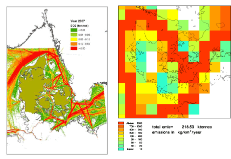
Fig. 1 Ship emissions of SO2 pr km2. The left panel displays values from the new, AIS-based emission inventory with a resolution of 1 x 1 km. The right panel illustrates the previously used inventory, where the emission is assigned to grid cells of size 50 x 50 km (EMEP, 2008).
For comparison, Fig. 1 also shows SO2 emissions according to the previous inventory from EMEP (2008), which has been the base for model calculations until now, and which has a crude resolution of 50 x 50 km. The previous inventory has been used for calculations in the framework of the Danish monitoring programme NOVANA (Ellermann et al., 2009; Kemp et al., 2008) - which, however, did not have particular focus on ship traffic. The previous inventory is referred to as EMEP-ref (se Chapters 3 and 4).
It appears from Fig. 1 that the new AIS-based inventory in detail shows how the ship routes appear as well-defined 'roads' at sea, as opposed to the old method, which has grid cells extending over both sea and land, and thus places some emissions from ships over land.
Other differences are less visible, but have consequences for the emissions: The previous inventory assumed that the engine load for ships was constant, whereas the new method takes account of differences in emissions, depending on the speed of the ship. The old method applied assumptions concerning the ship routes, whereas the AIS method is based on actual routes, based on a sample of 24 days in 2007.
The new method is regarded as a considerable improvement compared to the previous; however, there is still room for improvement – e.g., extension of the area with AIS signals, and use of a larger amount of AIS data than the 24 days which form the basis for the present calculations.
Assumptions for scenarios
The main assumptions underlying the scenario calculations are as follows.
- The IMO regulations for sulphur and NOX are implemented as planned. In particular, it is assumed that the marine waters around Denmark will be designated a NOX Emission Control Area (NECA) as defined by IMO. The countries around the Baltic Sea are preparing an application with this purpose. The status as NECA implies additional NOX emission restrictions for new ships from 2016.
- Concerning the amount of ship traffic, an annual increase of 3.5 percent has been assumed for transport of goods from 2011 and onwards, while passenger traffic is assumed unchanged.
- Concerning land-based emissions, a specific set of assumptions have been used. It is expected that in near future a new EU directive on national emission ceilings for 2020 (NEC directive) will be negotiated. However, there is not yet an official proposal for the directive. Therefore a scenario for emissions from land-based sources in Europe in 2020 has been set up, which is based on emission scenarios prepared in connection with EU's thematic strategy for clean air in Europe (see e.g. Bach et al., 2006), and scenarios for EU-27, prepared by the International Institute for Applied Systems Analysis (Amann et al., 2008) as part of the preparatory work for a new NEC directive. Further details are found in Section 4.4.
Emissions according to the scenarios
Fig. 2 displays the fuel consumption and emissions from ship traffic for the three scenarios: 2007, 2011 and 2020. The values refer to the area which is colored in Fig. 1(left).
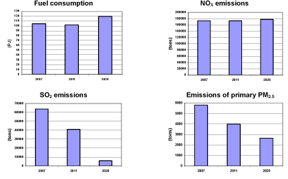
Fig. 2 Fuel consumption (Petajoule) and emissions from ship traffic in the waters around Denmark (cf. Fig. 1) for the three scenario years 2007, 2011 and 2020.
The calculations predict a 15% increase in fuel consumption from 2007 to 2020 as a result of increased traffic (36% increase for freight ships and unchanged passenger traffic), combined with increased efficiency for ship engines.
For emissions of nitrogen oxides (NOX) there is an expected growth of 2% between 2007 and 2020. Without stricter emission requirements the increase would have corresponded to the increase in fuel consumption (15%). Accordingly, the result of the IMO reductions is an average reduction in NOX emisssions of 11% per kg of fuel. Such relative reductions are expected to continue after 2020.
For sulphur dioxide (SO2) a reduction of 91% is envisaged between 2007 and 2020, while for primary PM2.5 the reduction is 54%. Primary particles account for only a minor fraction of the total amount of particles found in ambient air (see the section Concentrations of particles in this summary).
The most pronounced reductions in ship emissions take place for SO2. These reductions are illustrated in Fig. 3. The maps yield an overview of sea traffic around Denmark. Clearly visible are the main shipping lanes from the inner Baltic Sea (Bothnian Bay) to the North Sea, the major Danish domestic ferry routes, and the ferry routes connecting Denmark, Sweden, Germany and Poland.
Concentrations of sulphur dioxide
Ship emissions are a major source to pollution with SO2. Since 2007 it has been a requirement for ships in the Baltic Sea and the North Sea that the sulphur content in fuel should not exceed 1.5%, whereas previously it typically was 2.7% (Section 3.1). Nevertheless, ships are still an important source in comparison with land-based sources. Fig. 4 shows calculated concentrations of SO2, referring to, respectively, 2007 (with 1.5% sulphur in fuel) and 2020. The requirement to sulphur content in 2020 is considerably more restrictive than now (max. 0.1% sulphur), and this is clearly reflected in computed concentrations for 2020.
Since 1990, SO2 emissions from land-based sources have been substantially reduced, and in the years to come the reduction is expected to continue. Scenario calculations show that the SO2 concentration level for Denmark will decrease considerably over the period up to 2020, so in 2020 it will reach a level of 0.3 μg/m³, which is only 6% of what it was in 1990.
Fig. 5 shows the relative contribution from ship traffic, compared to the total from all sources, for SO2 as well as for several other pollutants. The values refer to an average over Denmark. The figure shows results from two sets of calculations: Calculations based on the new, more precise emission inventory (denoted AIS-2007), and calculations based on the older inventory from EMEP (denoted EMEP-ref).
The new inventory differs from the old in several respects: it assumes that sulphur content in fuel is 1.5 %, while the old refers to the situation before 2007 and uses 2.7 %; the new has a higher geographical resolution; it is based on more correct ship routes than the old; it uses more realistic data for the load of ship engines. The combined effect of all of these factors is that the new inventory has lower emissions. The reduction is most pronounced for SO2 and primary PM2.5, but also applies to other compounds. Whereas the calculations based on the previous inventory from EMEP ascribed 68% of the SO2 concentration level in Denmark to ship emissions, calculations based on the new inventory ascribe only 37% to ships.
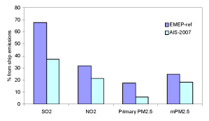
Fig. 5 Relative contribution from ships to the average concentrations of various pollutants in Denmark. The colour indicates which emission inventory the calculations are based on. The light blue columns use the new, more precise inventory ("AIS-2007"). The dark blue use the old emission inventory from EMEP ("EMEP-ref").
Concentrations of nitrogen dioxide (NO2)
IMO has adopted regulations of NOX emissions. In the present study it is assumed that the marine waters around Denmark will become designated a so-called NOX Emission Control Area as defined by IMO. This implies several restrictions on NOX emissions, in particular for new ships from 2016, where an 80 percent reduction in NOX emission is required. There are other, less demanding requirements to older ships.
However, at the same time an increase in ship traffic is foreseen. The reduction in emissions is not able to completely outbalance the foreseen increase in ship traffic, so the NOX emission from ships will be slightly higher in 2020 than in 2007. It is likely that the IMO requirements will result in lower ship emissions after 2020, but this is not the case for 2020. On the other hand, there are marked changes for land-based sources according to the scenario for 2020.
The result in terms of concentrations is seen in Fig. 6. NOX leads to formation of NO2, for which health-related limit values exist. Fig. 6 shows model calculated concentrations of NO2 for 2007 and 2020, respectively. respectively. The large shipping routes remain clearly visible, but inland concentrations decrease. The share from ships to the NO2 concentration level is 21% in 2007, but increases to 34 % in 2020 - because the absolute contribution from other sources is reduced.
It is an interesting result of the calculations that the concentration of NO2 in urban background in Copenhagen is expected to be reduced by 7 μg/m³ (from 16 to 9 μg/m³) in the period up to 2020. In several highly trafficked streets in Copenhagen the EU limit value of 40 μg/m³ is exceeded; this fact makes a large drop in background levels very interesting.
Concentrations of particles
Fine particles with a diameter less than 2.5 micrometer are referred to as PM2.5. One can distinguish between primary particles and secondary particles. Primary particles exist as particles immediately after they have left the source. Secondary particles were not 'born' as particles, but are created from gases, which undergo chemical transformation during transport – a process that continues for several hours or days after the pollution has left the source. Secondary particles can be further characterised as secondary inorganic particles or as secondary organic particles.
Emissions of SO2 and NOX from ships contribute to the formation of secondary inorganic particles. The DEHM model which is used for calculations of concentrations takes account of the processes involved. However, there is insufficient knowledge to describe the formation of secondary organic particles, and DEHM does not account for these. Internationally, this is recognised as being state-of-the-art for current models (see Yttri et al., 2009). Accordingly, the DEHM model accounts only for a certain fraction of the particles found in the atmosphere, namely the primary and the secondary inorganic. This part is here designated mPM2.5 (modelled PM2.5).
Fig. 7 shows calculated concentration levels of mPM2.5. PM2.5 can be transported over large distances, whereas SO2 and NO2 have a shorter atmospheric lifetime. This is the reason why the geographical pattern in Fig. 7 is very dissimilar to the previous figures. The pollution from ships is not visible, while it is a dominant feature that pollution from central Europe gradually declines over Denmark. The share of mPM2.5 attributable to ship traffic is 18%, while in terms of total PM2.5 the share from ships is considerably smaller. Relative to total PM2.5 in Copenhagen, the share from ship traffic can be estimated to around 4-7%, depending on whether one considers the air in a highly trafficked street or in urban background (e.g. a park).
In the time up to 2020 a reduction of the general level of mPM2.5 will take place, amounting to slightly more than 2 μg/m³. This is mainly due to emission reductions for land-based sources.
Version 1.0 October 2009, © Danish Environmental Protection Agency