Ship emissions and air pollution in Denmark
1 Introduction
- 1.1 Background
- 1.2 AIS data
- 1.3 New regulations and projections
- 1.4 Relation to previous studies
- 1.5 Structure of the report
The work described in the present report covers several aspects of the contribution from ships to air pollution in Denmark. The main focus of the report is to describe a newly developed and more accurate emission inventory for air pollution related to ship traffic in the Danish marine waters, and to use this inventory to determine the contribution from ships to concentration levels within Denmark. Further, the study includes scenario calculations for years 2011 and 2020. These scenario calculations are used to assess the effect that international regulations of ship emissions and other regulations will have for the future air pollution in Denmark. A minor component of the work concerns the contribution from ships at port to local air pollution in the ports of Copenhagen and Aarhus.
1.1 Background
Emissions from ship engines contribute to air pollution with sulphur dioxide (SO2), nitrogen oxides (NOX), particulate matter (PM) and Volatile Organic Compounds (VOC). Furthermore, ship engines emit the greenhouse gas CO2. Focus of the present report is, however, on traditional pollutants, not on CO2.
Previous investigations have made clear that the contribution from ships to emission of SO2 and NOX is considerable, compared to land-based sources, and that there is a substantial effect on inland concentrations. It is important to note that even though NOX and SO2 are gases, they will contribute to the formation of particles. Some of the particles present in ambient air have been emitted as particles (primary particles), while others (secondary particles) have been formed through chemical and physical reactions in the atmosphere. Thus, although SO2 and NOX are emitted as gases, they will affect inland concentration levels for both these gases themselves, as well as for reaction products, including particles.
Pollution with particles is of considerable interest, because particles are associated with negative health effects. A commonly used measure for particle pollution is concentration in terms of PM2.5, i.e. particles smaller than 2.5 micrometer. This is referred to as the fine fraction of particle pollution.
As mentioned above, one can distinguish between primary particles and secondary particles. Secondary particles can be further characterised as secondary inorganic particles or as secondary organic particles. All types of particles are present in ambient air. Note, however, that emission inventories take account only of primary particles, because only these are actually emitted from the sources. The DEHM model - which is applied to compute concentration levels in ambient air in Chapter 4 - also takes account of the formation of secondary inorganic particles. Some of these originate from ship emissions of SO2 and NOX. However, DEHM does not account for secondary organic particles. This question is elaborated in Chapter 4, in particular sections 4.2 and 4.9.
The present study represents no attempt at evaluation of health effects; it considers only concentration levels of various compounds.
1.2 AIS data
Since 2006 the so-called AIS system - Automatic Identification System - has been implemented in the marine waters around Denmark. It is required that all ships greater than 300 GT carry an AIS transponder. With very short time intervals the transponder transfers signals to land-based stations, providing information on ship identity, position, destination etc. This type of information provides the basis for estimates of the ship emissions and their spatial distribution in the present study. The methodology is described in detail in Chapter 2. The spatial distribution of emissions becomes much more precise with use of AIS data than with previously available data.
In the present study, AIS data were requested from DaMSA (Danish Maritime Safety Administration). Since AIS signals represent a huge amount of data, only data from a limited area around Denmark were requested from DaMSA as illustrated in Figure 1.1. Furthermore, in order to represent the year 2007, not all data for the entire year was considered. The present project uses 12 two-days periods, one period for each month, representing both weekend days and normal working days. From DaMSA data the following information was used: Vessel IMO and MMSI codes, call sign, time of AIS signal, and latitude-longitude coordinates. For each ship, the sailing speed between two AIS signals was calculated from the time between the signals, and the corresponding latitude-longitude registrations.
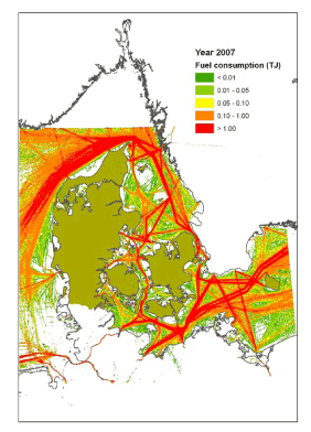
Figure 1.1 Fuel consumption according to AIS data with application of the methodology described in chapter 2. The unit is TJ/km². The coloured area on the map illustrates where the AIS data are applied in the present study. In the following, it will be referred to as the AIS inventory area.
79 % of the ships were identified as entries in Lloyd’s Registers technical database. A reasonable assumption was that the ships not included in the latter database were merely small vessels. Further assessment of the number of ships and fuel consumption estimates, also made it reasonable to assume that emission results the 12 periods could be extrapolated to cover a full year emission estimate.
1.3 New regulations and projections
The present study considers the current situation, as well as two projections. In 2008, the International Maritime Organisation (IMO) agreed on new, stricter rules for the emissions of SO2 and NOX, to be implemented stepwise in the period towards 2020.
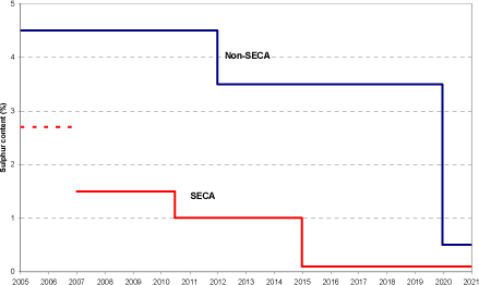
Figure 1.2 Limit to sulphur content in heavy fuel oil, according to IMO regulations. The SECA regulations were implemented in the Baltic Sea in 2006 and in the North Sea in August 2007. For calculations in the present report, SECA regulations have been assumed in effect during the entire year of 2007. The broken line indicates 2.7% which was the assumed level prior to 2007.
Figure 1.2 illustrates the requirements for sulphur content in heavy fuel oil, which is the most common marine fuel. SECA stands for SOx Emission Control Area. The curve labelled Non-SECA represents the general requirements, applicable everywhere. In SECA's requirements are stricter. The Baltic Sea and the North Sea[¹] have been appointed SECA areas, with the stricter requirements implemented in 2006 and August 2007, respectively (see chapter 2 for details). Prior to 2006, the sulphur content in fuel used by ships in these areas has assumed to be 2.7%, in accordance with Cofala et al. (2007) - see Section 3.1 for more details.
The basic scenario that is taken to represent the current situation is the year 2007. In computations for this scenario it has been assumed that the Baltic Sea and North Sea were SECA areas during all of 2007.
NOx emissions are regulated by IMO (Marpol 73/78 Annex VI, and further, amendments) in a three tiered emission regulation approach, as follows:
- Tier I: Diesel engines (> 130 kW) installed on a ship constructed on or after 1 January 2000 and prior to 1 January 2011.
- Tier II: Diesel engines (> 130 kW) installed on a ship constructed on or after 1 January 2011.
- Tier III: Diesel engines (> 130 kW) installed on a ship constructed on or after 1 January 2016.
Tier III applies only in areas, which have been designated NOX Emission Control Area (NECA). The countries around the Baltic Sea are preparing an application to obtain this status for the Baltic Sea. It is assumed for the 2020 scenario that the marine waters around Denmark are a NECA.
As it appears from Figure 1.2 there will be substantial reductions in sulphur content in SECA areas in 2010 and 2015. Furthermore, the NOx emissions from new engines become significantly lower in the period considered. The effect of these measures has been studied, based on projected emission scenarios for the years 2011 and 2020, in addition to the baseline scenario for 2007.
The scenarios take account of a general increase in ship traffic during the period up to 2020. In accordance with expectations from the Danish Ship-owners' Association (see chapter 2) it has been assumed that, due to the financial crisis, ship traffic has dropped since 2007, but will again in 2011 reach the level of 2007. From 2011 and onwards, an annual increase of 3.5 percent has been assumed for transport of goods, while passenger traffic is assumed unchanged.
1.4 Relation to previous studies
Many previous studies from NERI have included emissions from ships as one of the sources to air pollution, whereas they have not addressed the contribution from ships separately. Among such studies are annual reports on the Danish monitoring programmes (e.g. Kemp et al., 2008; Ellermann et al., 2009).
The present study is the first to make use of AIS data for air pollution studies in a Danish context. In other countries the use of AIS data for construction of emission inventories has recently started.
A related study is the report by Winther (2008) on fuel consumption and emissions from navigation in Denmark, which is, however, focussed on national Danish ship traffic.
In 2001, emission inventories for 1995/1996 and 1999/2000 were compiled by Wismann (2001), estimating the fuel consumption and emissions for all sea transport in Danish waters.
Other Danish projects were the assessment of the fuel consumption and emissions for ships in Danish ports (hotelling, manoeuvring, landing/loading) by Oxbøl and Wismann (2003), and the examination of air quality effects from cruise ship activities in the Port of Copenhagen by Olesen and Berkowicz (2005). Other studies concerning pollution in ports are also relevant and will be discussed in Chapter 5.
1.5 Structure of the report
The report has the following structure.
Chapter 2 provides a comprehensive description of the methodology applied for constructing the detailed AIS-based emission inventories, which form the basis for the further calculations. The inventories are for the years 2007, 2011 and 2020. It is described how AIS data obtained from DaMSA are processed in order to determine time, position and speed for each ship in the AIS inventory area. Further, the chapter explains how speed based engine load functions are used to estimate the instantaneous ship engine load. The emission factors are described, as well as relevant ship technical data obtained from e.g. Lloyd’s Register. The emissions are calculated as a product of emission factors, engine size, engine load and time between AIS signals. Emission results are shown for 2007, 2011 and 2020 in details per engine type, fuel type and ship category. Results are also listed per flag state, and GIS maps show the geographical distribution of emissions in the AIS inventory area.
Chapter 3 goes one step further from the AIS-based inventories. In order to apply these inventories in an air pollution model, it is necessary to combine them with emission data covering a much larger geographical data. Chapter 3 presents the inventories for ship emissions that are used for model runs with the air pollution model DEHM (Danish Eulerian Hemispheric Model). It is described how the AIS-based inventories from Chapter 2 are combined with emission data provided by EMEP (Co-operative Programme for Monitoring and Evaluation of the Long-Range Transmission of Air Pollutants in Europe). The EMEP estimates are characterised by a cruder geographical resolution, and there are interesting differences between the two sets of inventories which are discussed.
Chapter 4 describes how the ship emissions are combined with emissions from land-based sources and aviation. However, the bulk of the chapter is devoted to a presentation and discussion of results for concentrations, obtained with the air pollution model DEHM (Danish Eulerian Hemispheric Model). The chapter includes a quantification of the contribution from ships to concentration levels in Denmark. Further, it presents scenario calculations, demonstrating the combined effect on concentration levels of the IMO measures and the expected changes in land-based emissions. Finally, it considers the influence of ship traffic on general concentration levels in the Copenhagen area.
Chapter 5 presents results of studies of local pollution from ships at port in Copenhagen and Aarhus.
Conclusions are found in the section Summary and conclusions in front of the report.
[1] In the context of SECA's the Baltic Sea and the North Sea are larger than their normal delimitation; the two SECA's are adjacent and include the inner Danish waters.
Version 1.0 October 2009, © Danish Environmental Protection Agency