Guidelines on remediation of contaminated sites
5. Risk assessment
5.1 Definitions, procedures and data requirements
A risk assessment is an evaluation of environmental and health-related effects of contamination. The purpose is to assess the need for protective measures, since a specific risk assessment is a precondition for any such protective measures.
Risk assessments appraise specific circumstances and are based on information about actual contaminants, transport and exposure pathways as well as target groups at risk in each given situation. The risk assessment must be based on:
| The results of the investigations, including the nature and extent of contamination as well as prevailing geological, hydrogeological and hydrological conditions. | |
| A hazard assessment pertaining to the contaminants of interest. | |
| A survey of possible ways of transport and exposure pathways (vulnerability assessment). | |
| Knowledge of the target groups exposed. |
A specific risk assessment will highlight interconnected ways and effects that may constitute a hazard to the target group. Further principles for carrying out a risk assessment may be found in Environmental Project 123/12/. In these guidelines, the main focus is on human exposure. On rare occasions, it may also prove necessary to take ecotoxicological aspects into consideration.
A hazard assessment is an review of the inherent characteristics of a potential contaminant. Qualitatively, a hazard may be described as carcinogenic, corrosive, toxic, etc. and effects may characterised as acute and more long term (chronic effects). Whenever possible, the hazard is quantified by determining the concentration level at which harmful effects arise.
Determining the inherent hazard of a given contamination incident entails a comprehensive assessment of toxicity, biodegradability, bioavailability, and mobility.
For a number of relevant substances, hazard assessments have already been carried out in connection with the setting of quality criteria and B-values. Data sheets and brief profiles of pertinent substances, their effects and the basis for each calculation have been prepared (9, 10, 11).
Vulnerability is assessed by considering the possible transport and exposure pathways as illustrated in Figure 5.1.
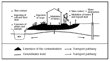
Figure 5.1
Transport and exposure pathways
Frequently, the vulnerability of the environment can be assessed by evaluating the three most important considerations; health considerations in connection with land use, groundwater protection considerations and considerations regarding surface-water recipients and soil.
The section dealing with investigations (section 4) mentions overall requirements regarding the parameters to be measured. It is therefore important that the risk assessment is planned as an integral part of the investigation work.
Soil contamination cannot be clearly distinguished from soil gas or groundwater contamination. In the saturated zone, the space between soil particles is filled with groundwater. The contaminants are in a state of dynamic equilibrium between soil particles and groundwater. Similarly, there is air and water between the soil particles in the unsaturated zone and the volatile substances will reach a dynamic equilibrium between soil, soil gas, and water.
Thus, while distinction between the contamination of soil, groundwater and soil gas may be difficult in a purely physical sense, it may still be useful to carry out separate risk assessments in connection with land use, groundwater and evaporation.
5.2 Land use
5.2.1 Definitions
When remediating a contaminated site, various soil types may be encountered: undisturbed soil that is contaminated, excavated soil that is either contaminated or non-contaminated, and soil conveyed from an external source. The situation is illustrated in figure 5.2.
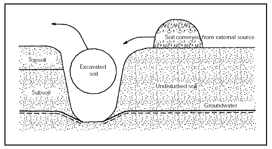
Figure 5.2
Outline of soil types which may be encountered in remediation of a contaminated site.
Much topsoil in urban areas is typically composed of fill.
These guidelines distinguish between:
| Soil which is used in excavations at the site, be it from other parts of the site, or soil conveyed from an external source or treated soil. | |
| Topsoil. This is the uppermost and thus the most sensitive soil with regard to surface-related activities. Topsoil thickness typically varies from 0.25 m to 1 m, depending on what the site is used for. | |
| Subsoil. This is the stratum between the underside of topsoil and the groundwater level. |
When conducting risk assessment of contaminated sites, one must discriminate between the concepts of quality criteria, acceptance criteria and cut-off criteria. These concepts are defined in Figure 5.3.
In these guidelines, prime attention is given to human exposure. For ecotoxicological aspects, please refer to the Project on Soil and Groundwater from the Danish EPA, about ecotoxicological soil quality criteria /10/.
It should be noted that compliance with soil quality criteria does not automatically ensure compliance with criteria pertaining to groundwater or air. The quality criteria are described further in Chapter 6.
|
Figure 5.3
Soil criteria definitions.
5.2.2 Exposure
Soil contamination may pose a threat to humans, animals or plants in cases of land use at ground-level. This problem will primarily involve topsoil.
For humans, the following exposure pathways exist:
| Ingestion soil. | |
| Eating crops grown on the soil. | |
| Skin contact with soil. | |
| Inhalation of soil particles. | |
| Inhalation of fumes from soil. |
In addition to the effects on humans, exposure of plants and animals may take place..
Crucial exposure pathways will typically depend upon site use, since different land uses of a given site will lead to distinct patterns of activities. The following factors will be of significance in
| Accessibility of contamination | |
| Duration of exposure | |
| Exposure pathways | |
| Sensitivity of the user group |
Sensitivity of various site uses is subdivided into three levels: highly sensitive, sensitive and non-sensitive (see Figure 5.4). The most sensitive land uses of contaminated sites involve an evident likelihood of children ingesting soil and/or the possibility of human exposure to unacceptable, health-impairing exposures through inhalation of fumes from volatile contaminants.
The depth of land use is the depth to which the soil is regularly used at a given site. Construction work deeper than the depth of land use may entail the need for appropriate measures.
Generally, the minimum depth of land use should be:
| 1 m. Where land use is highly sensitive, i.e. in the gardens of private homes and in day-care facilities, since soil may be frequently worked, etc., and edible crops may be grown. | |
| 0.5 m. In park areas and other publicly accessible spaces with varying, albeit primarily permanent planted areas. | |
| 0.25 m. Where an area is permanently consolidated or covered with grass, thus excluding any further earth works etc. |
Circumstances may arise where the depth of land use exceeds the above or where, occasionally, the need to work at deeper layers arises. Such circumstances may occur when planting or digging up trees, or when carrying out excavation work in connection with construction activity.
The Environmental Project number 123 from the Danish EPA /12/ contains an overview of the patterns of exposure encountered in connection with many normal land uses This figure is reproduced, in a somewhat modified form, as Figure 5.4. Working from the above guidelines, a specific assessment is decided upon in each instance; i.e. an acceptance criterion is established.
In connection with soil remediation, specific clean-up depths may be proposed, based on the land use depth of the individual site. As a consequence, this can result in remediation at depths with are less than the depth of land use or depths that are greater than the depth of land use due to removal of vegetation, thawing, subsidence or evaporation to the surface from lower, contaminated soil strata (refer also to Section 5.2.3.).
Typically, this means that no general, differentiated acceptance criteria with respect to the duration of exposure for a specified land use can be determined for a planned remediation, Instead, the chosen parameter is the land use depth at which the soil quality criteria must be met.
Land use |
Sensitivity |
User |
Site |
Daily duration |
Ways of |
||
Inh. |
SkC. |
Ing. |
|||||
Roads, |
Non- |
Healthy |
Paved |
Minutes |
(+) |
- |
- |
Industrial |
Non- |
Healthy |
Buildings |
8 hours |
++ |
- |
- |
Office |
Non- |
Healthy |
Buildings |
8 hours |
++ |
- |
- |
Shops: foodstuffs other |
Non-sensitive/ |
Healthy |
Buildings |
Employee/- |
|
|
|
Blocks of |
Sensitive |
Healthy |
Buildings |
24 hours |
+++ |
- |
- |
Private |
Highly |
Healthy |
Buildings |
24 hours |
+++ |
- |
- |
Allotment |
Sensitive |
Healthy |
Buildings |
4-8 hours |
+++ |
- |
- |
Re- |
Sensitive |
Healthy the sick |
Grass |
3-5 hours |
(+) |
+ |
+ |
Schools |
Sensitive |
Healthy |
Buildings |
4-8 hours |
++ |
- |
- |
Kinder- |
Highly |
Healthy adults, children, pregnant women |
Buildings |
8 hours |
++ |
- |
- |
Nursing homes |
Sensitive |
Elderly, sick, healthy adults, pregnant women |
Buildings |
24 hours |
+++ |
- |
- |
| - | : no likelihood of exposure | Inh. Inhalation |
| (+) | : slight likelihood of exposure | SkC. Skin contact |
| + | : some likelihood of exposure | Ing. Ingestion |
| ++ | : greater likelihood of exposure | |
| +++ | : great likelihood of exposure |
Figure 5.4
Exposure patterns for various site uses
An important element of risk assessment is to establish acceptance criteria for the contaminant with respect to the sensitivity of the specific land use.
For quite a number of substances, the Danish EPA has determined toxicological quality criteria for soil involving highly sensitive land use. These quality criteria are listed in Figure 6.1.
In the case of ten selected substances, soil contaminant cut-off criteria have been specified for highly sensitive land uses regarding the upper soil strata. The cut-off criteria indicate at which point compliance with basic advisory precautions will no longer reduce exposure to the same level that compliance with the soil quality criteria ensures.
The cut-off criteria are explained in Figure 6.2.
The soil quality criteria and cut-off criteria apply to the depth of land use. Compliance with the EPA's soil quality criteria does not preclude that near-surface contamination may pose a risk for recipients/groundwater or emit unacceptable evaporation to outdoor or indoor air (see Sections 5.3 and 5.4).
If remediation without subsequent regulation with a view to future land use is desired (equivalent to unconditional closure under the Waste Deposit Act), the soil quality criteria should be met down to roughly 3 m below ground level, unless the groundwater level is closer to the surface and therefore a limiting factor. There can, however, be some situations where it is necessary to remove or remediate deeper contamination due to the risk for contamination of groundwater or where there is a limited extra expense involved in removal of all of the contamination.
If land use and therefore the risk of exposure is regulated administratively, there will not be a need for physical remediation such as excavation, placement of geotextile, etc. The reason is that administrative regulation can ensure that no exposure to the contaminants occur.
I land use is regulated so restrictively that contact to contamination cannot and will not take place (working the soil such as construction, landscaping, etc.) or if the area is paved or has a permanent grass cover, then the depth of land use may be considered nil.
Possible deterioration or drying out of an area with permanent grass cover can lead to the formation of areas with bare soil and will require that entry to the area is forbidden until the grass cover is re-established. The administrative regulation will therefore demand continuing responsibilities and maintenance.
Reducing the depth of land use via administrative regulation, should take place after weighing the possible inconveniences with the cost of obtaining a greater depth of land use.
In practice, some areas will exist where a administrative regulation is not appropriate or where nil depth of land use cannot be ensured. For volatile substances, additional administrative regulation of an area forbidden entrance or residence may be required even in cases with a nil depth of land use. This is due true for instances where evaporation of the contaminant to the outdoor air presents a risk.
A risk assessment must identify all present and/or potential land use conflicts.
Based on the risk assessment, a decision is made as to the appropriate course of action, clean-up/replacement or advisory measures. Steps taken must eliminate the present conflict of land use.
In the practical performance of a remediation task, compliance with the acceptance criteria to the prescribed land use depth must be ensured.
It is acceptable to let residual contaminants remain at depths below the normal land use depth. In all cases, "Hot spots" containing high levels of contamination (e.g., gas purification residue, buried chemical depositions, drums and tanks formerly used for petrol or tar) should be removed or dealt with. There may be circumstances where it is not immediately practical or economically feasible to undertake a clean-up according to the acceptance criteria. Moderate conflicts of land use may be obviated by use of advisory precautions which ensure an acceptable reduction of exposure (see section 6.3).
It is also possible to replace the top 30 cm or use administrative regulation which reduces or prevents exposure with contaminants.
In cases of highly sensitive land use where conflicts of land use are resolved by replacing the top 30 cm with clean soil, defined as soil meeting soil quality criteria, the contaminated soil lying below must be separated from the clean soil using geotextile and/or an identification net.
The purpose of the geotextile is partly to prevent any contact with contaminated soil and partly to prevent any mixing of clean and contaminated soil. Information regarding the contamination deeper than the geotextile must be available to the public. Such information must be contained in an administrative system, such as the "Bygnings- og Boligregistret, BBR", and will thus be imparted to the owner in notifications of changes. Furthermore, any activities deeper than the geotextile will require compliance with special precautions.
Whenever investigations show that soil quality criteria at depths exceeding 30 cm are exceeded while criteria from ground level to 30 cm have been met, highly sensitive land use will require the removal of the upper 30 cm and the use of geotextile before the land is reinstated for use.
I areas with sensitive land use, including parks and park-like areas, it is not always necessary to remove contaminated soil if administrative regulation can limit exposure to an acceptable level or prevent exposure altogether.
Familiarity with background levels of naturally occurring substances as well as xenobiotic substances are important elements in any health assessment.
Thus, soil quality criteria are not to be uncritically employed in instances where the natural background level of a given substance exceeds the soil quality criterion. This may be the case for certain metals.
5.2.4 Assessment of soil contamination
In the following, principles regarding the assessment of soil contamination in the uppermost metre as it relates to land use conflict are described for the case of highly sensitive land use.
The starting point is that any small, yet consistent, transgression of the soil quality criteria in an area necessitates remediation (advisory precautions, cut-off, excavation, or the like).
If the soil quality criteria is exceeded at a potentially contaminated site, the contamination is mapped and remediation takes place.
If there is a tendency towards falling concentrations as a function of distance from the highest concentrations, a hot spot likely exists, even if historical records do not indicate a potential contamination source at the location. The area must be mapped, and the contamination remediated.
A single value which exceeds the criteria does not constitute grounds for declaring a hot spot, and can therefore not prompt a mapping investigation. A hot spot must be verified by several analyses.
In some cases, it may be possible to identify a characteristic fill layer with concentrations that exceed soil quality criteria. Fill layers may be visually recognised in soil profiles by the presence of slag, certain types of construction waste, soil type, colour and so forth. The extent of the fill layer not in compliance with soil quality criteria must be mapped, and remediation initiated.
If transgressions of criteria occur randomly over the entire area - thus precluding the existence of a hot spot or specific contaminated layer - the above procedure cannot be followed.
In the event of such diffuse contamination, assessment is carried out according to two different procedures, depending on whether the contamination involves a substance where a chronic or sub-chronic effect has been the determining factor in setting soil quality criteria, or whether it involves a substance where an acute effect has prompted the quality criteria set.
Substances in which a chronic, harmful effect is the determining factor in setting the quality criteria (e.g. lead, cadmium, benz(a)pyrene and total PAH), the area may be used for highly sensitive land use only if the average of all tests conducted lies below the soil quality criteria that have been set.
Substances in which an acute harmful effect is decisive in setting the quality criteria (like arsenic, or nickel), the area may be used for highly sensitive land use, provided both of the following criteria are met:
| The average of all samples lies below the quality criteria set. | |
| A maximum of 10 per cent of all samples show results exceeding the established soil quality criteria; while none of these exceed soil quality criteria by more than 50 per cent. |
Table 6.1 identifies whether an acute or a chronic effect has prompted the establishment of the quality criteria for the individual substances.
The above principles assume that a contaminated area that is relevant to the land use is investigated. In other words, samples from areas known to be uncontaminated may not be included.
As an absolute minimum, analyses comparable to level 1 in the Guidelines on sampling and analysis of soil should be performed /3/.
5.3 Evaporation, including landfill gas
In buildings or outdoor areas above contaminated ground, there is a risk of an unacceptable influence on the indoor or outdoor air from contaminants in the soil or groundwater. This may be caused by volatile substances. Among the substances present at contaminated sites, the risks are greatest when contamination involves highly volatile organic solvents, including chlorinated solvents. Furthermore, methane rising from landfills may constitute a risk of explosion.
Below, different methods of risk assessment with respect to outdoor air, indoor air and landfill gasses, are dealt with separately.
All methods involve different procedural steps. Several of these steps implement different theoretical methods of computation for the interrelationship between the soil contaminant content and the evaporation which may be expected from this source and its conveyance to the outdoor or indoor air. The models are described in Appendix 5.2-5.4. These models provide a conservative estimate of the contamination contributed to the outdoor or indoor air. The models have been included in these guidelines because they are fairly simple; they may only be used under the circumstances and provisos outlined in the Appendices.
More advanced models which allow for degradation and water infiltration have been described in a project concerning the dynamics of chemical substances in soil and groundwater /13/ and will not be dealt with further here.
In addition to factors like the nature and concentration of the contaminants in question, many other factors determine how contaminants evaporate into the air, be it inside or outside a building. These factors include:
| Depth of contamination | |
| Porosity and water content of soil layers | |
| Building design and the materials used for its construction | |
| Temperature and pressure gradients surrounding the building | |
| Building ventilation |
Interpretation of measurements and calculation results may be made difficult by the presence of other types of indoor or outdoor contamination, e.g., degassing from building materials, furniture, carpeting etc, smoking, traffic, nearby industrial plants, etc.
5.3.1 Outdoor air
Volatile contamination poses a risk of unacceptable evaporation to free areas (vacant or unpaved areas).
Figure 5.5 displays a flowchart delineating a model for handling risk assessment with regard to the outdoor air at contaminated sites designated for a highly sensitive land use.
Figure 5.5
Flowchart for outdoor-air risk assessment
This model is based on analysis results obtained through soil and/or water samples and involves four different steps:
- Calculation of soil gas and outdoor air concentrations
- Measurements of soil gas concentration
- Calculation of outdoor air concentration
- Conducting measurements of the outdoor air
As is evident from Figure 5.5, each step in the assessment will either lead to the contamination being deemed non-problematic; or it will lead to the next step in the flowchart. Below are guidelines for each step:
The soil gas concentration, Cp, is determined under the assumption that the phase distribution (i.e. the distribution of individual contaminants between soil gas, pore water, a phase absorbed in the soil matrix, and, occasionally, a separate contamination phase) may be calculated using the fugacity principle.
Formulae for calculating contamination distribution in the soil may be found in Section 3.1 of Appendix 5.3.
Parameters included in the calculation of phase distribution are:
| Soil type, soil porosity, water content, grain density, total density, calculated temperature and organic content. | |
| Molecular weight, soil-to-water ratio, vapour pressure and solubility |
An example showing the calculation of evaporation of volatile substances from soil can be found in Appendix 5.4.
Chemical data for selected substances are given in Appendix 5.5. Standard data pertaining to soil types is listed in Appendix 5.3 (table 1, section 4).
Risk assessment is based on the principle that evaporation from soil to the air above must not exceed the evaporation criteria, Ca. Evaporation criteria for several substances may be found in Section 6.6; this section also demonstrates how evaporation criteria for substances other than those listed may be obtained.
Based on Danish EPA experience, the above criteria are considered to be met, provided soil gas concentrations remain less than 10 times the evaporation criteria.
For volatile substances, calculations of the soil gas concentrations in actual soil contamination cases tend to show that soil gas concentration exceed the evaporation criteria by at least 10 times.
Consequently, it is necessary to calculate how much the contamination contributes to the outdoor air.
Formulae for calculating the diffusive contribution to the outdoor air may be found in Section 3.3 of Appendix 5.3. Parameters included in the calculation are:
| Total porosity, water content, soil type, and thickness of each diffusion-inhibiting soil layer. | |
| Diffusion coefficient for the substance. | |
| Vertical mixing height. | |
| Wind velocity. |
As a minimum requirement, the type of soil and the thickness of the diffusion-inhibiting layers of soil must be determined. Total porosity and water content may be estimated, based on the type of soil in question. Standard data may be used for vertical mixing height and wind velocity.
If the calculated, outdoor-air contribution exceeds the evaporation criteria, Ca, soil gas or outdoor-air measurements will have to be carried out.
In this model, estimates of soil gas concentration are very conservatively. Therefore, if the calculated outdoor air concentration exceeds the evaporation criteria, the soil gas concentration should be measured.
Soil gas measurements of organic gasses must be carried out according to guidelines laid down in Section 4.3.1 and Appendix 4.4.
If measurements show that the soil gas concentration, Cp, exceeds the evaporation criteria by more than ten times, it cannot be ruled out that the contamination is problematic as regards the outdoor climate. Calculations that determine outdoor-air effects are then carried out as described above.
Should measurements indicate that outdoor air concentrations, Cu, exceed the evaporation criteria, it cannot be ruled out that the underlying contamination constitutes a problem and demands remediation. As mentioned previously, heavily-trafficked urban areas or industrial zones may have very high background levels.
Before the final decision to remediate a specific site is made, it must be determined if it is probable that the increased outdoor air concentration is in fact due to soil or groundwater contamination. This may be done by comparing concentrations with outdoor air measurements carried out at (uncontaminated) neighbouring sites.
5.3.2 Indoor air
As with outdoor air (Section 5.3.1), risk assessment of indoor air in buildings located on plots allocated for residential, institutional or office purposes is based on the proviso that the evaporation emanating from the underlying contaminants into the indoor air must not exceed the evaporation criteria, Ca (see Section 6.6). The evaporation criteria Ca are not indoor air limits, but limit values applying solely to the maximum contribution to indoor air permissible from underlying contaminants.
In the case of non-sensitive land use, e.g. production facilities, other criteria for permissible evaporation levels are established for substances involved in production processes.
Figure 5.6 displays in a flowchart how to manage risk assessment of indoor air.
Figure 5.6
Flowchart for risk assessment of indoor air
This model is based on the results of analyses of soil and/or water samples and operates with four different steps:
- Calculating the soil gas concentration and evaporation into the indoor air
- Measuring the soil gas concentration
- Calculating the concentration contribution to indoor air
- Conducting measurements of indoor air
As can be seen from Figure 5.6, each step in the assessment will either lead to the contamination being deemed non-problematic; or lead to the next step in the model.
Below are guidelines for each step in the flowchart:
Calculation of the soil gas concentration, CL, is identical to the first step of the model for outdoor risk assessment. For details, please refer to section 5.3.1.
The majority of Danish residential and institutional buildings are constructed using flooring that contains a layer of concrete and passive ventilation of approximately 0.3 times an hour for residential buildings and approximately 2.0 times an hour for institutions.
Therefore, a dilution factor of 100 is considered a conservative estimate of the reduction in the contribution of soil gas concentration to the indoor air concentration.
If the calculated soil gas concentration, CL, is less than 100 times the evaporation criteria, the underlying contamination is thus considered non-problematic. The conservative reduction factor of 100 is based on the building practices outlined above. Therefore, this reduction factor cannot be applied to buildings with wooden flooring, or concrete floors with large, visible cracks.
As mentioned previously, the calculation of soil gas concentration chosen in this model is very much on the safe side. When applied, a calculation of volatile substances will tend to be at least 100 times larger than the evaporation criteria, meaning that the contribution to the indoor air will have to be calculated.
Since the calculation of the soil gas concentration has been set on the safe side, the most expedient procedure will often be to start by measuring the concentration in the soil gas (refer to the guidelines in Section 4.3.1 and Appendix 4.4). The indoor air contribution may be calculated or the indoor air concentration may be measured.
If the measured soil gas concentration under the floor, Cp’, is higher than 100 times the evaporation criteria, it cannot be ruled out that the contamination is in excess of the evaporation criteria.
If the concentration in soil gas is calculated, the contribution to the indoor air must be calculated; likewise, this contribution is calculated if measurements of soil gas concentration prove to exceed evaporation criteria by a factor of 100 or more.
In order to undertake a practical calculation of the concentration contributing to the indoor air, technical construction details must be collected.
Concrete can be divided into four environmental classes:
| aggressive environmental class | |
| moderate environmental class | |
| passive environmental class | |
| non-reinforced concrete with no environmental class |
The diffusion contribution through concrete is primarily dependent on the environmental class of the concrete and the aggregates porosity /54/. The contribution to convection is primarily dependent on the reinforcement.
In these calculations, a distinction is made between reinforced concrete flooring laid in accordance with the Radon guidelines /14/ and non-reinforced concrete flooring.
Technical construction details may be procured from original construction plans and descriptions as well as from on-site measurements. Methods for conducting air exchange measurements as well as crack and fissure measurements may be found in publications from the National Housing and Building Agency (Bygge- og Boligstyrelsen) /7, 16/.
Where reinforced concrete flooring is concerned, numerous parameters are included in the following calculations. Since collecting all this information will probably not be possible, and since it is not all of equal importance, the relative "importance" of the various parameters is listed in Figure 5.7.
Great importance |
Thickness of the concrete |
Lesser importance |
Pressure variances across concrete cover |
Slight importance |
Reinforcement used in concrete |
Figure 5.7
Overview of input parameters for reinforced concrete flooring
The minimum requirement is for concrete thickness to be measured. For concrete age, 20 years is used in the risk assessment; however, the actual age may be used if measured and calculated concentrations are to be compared. Concrete air humidity at the time of pouring and hardening will rarely have been ascertained in the case of existing concrete coverings, but may be managed for new concrete coverings.
In the case of non-reinforced concrete coverings, information may be collected on the thickness of the concrete, ceiling height, air exchange, floor area as well as the lengths and widths of cracks.
When calculating a contaminant’s contribution to the indoor air, one must calibrate the diffusive as well as the convective contribution. Formulae for calculating the diffusive concentration contribution to the indoor air are found in Section 3.4 of Appendix 5.3.
Parameters for these calculations include:
| Material constant and thickness for each of the diffusion-inhibiting layers of flooring. | |
| Ceiling height and air exchange for each ventilated room, as well as porosity in the case of ventilated drainage. | |
| Year of construction of the building/age of the flooring. |
A set of formulae for calculating the convective concentration contribution to the indoor air through reinforced concrete flooring can be found in Section 3.5 of Appendix 5.3.
For an overview of calculation parameters, please refer to Figure 5.7. Standard data for concrete coverings and buildings may be found in Tables 2 and 3 of Appendix 5.1, section 4.
Appendix 5.4 provides an example of calculation of the diffusive and convective contributions.
If the calculated contribution to the indoor air, Ci, (the sum of the diffusive and the convective contributions) exceeds the evaporation criteria, indoor air measurements may be undertaken, or the basis of calculation may be enhanced by measuring the soil gas concentration.
Measurements of the indoor air should be carried out in accordance with the guidelines issued by the Housing and Building Agency /7/.
A considerable number of volatile organic substances may be expected to contribute to the background level in Danish buildings. A list of background levels can be found in G.M. Nielsen et al. /18/ and addition information is found in a report from the Housing and Building Agency /15/.
Thus, on the sole basis of measuring the indoor air concentration, Ci’, it remains difficult to assess whether the concentration contribution from the residual contaminants exceed to the evaporation criteria.
Before a final decision is made to initiate remediation, it must therefore be determined whether it is likely that indoor concentrations exceed limits due to soil or groundwater contamination.
A comparison of the measured indoor air concentration must be made with the median value of the background levels, combined with a thorough investigation of plausible "additional" contributions to indoor levels stemming from building materials, furniture and fixtures, leisure activities or smoking.
5.3.3 Landfill gas
Sites formerly used for landfills may have problems with:
| Rising methane gas which may pose an explosion hazard for buildings and "hollow" installations at the landfill or in its immediate vicinity. | |
| Contaminants (typically heavy metals) in topsoil layers, due to inadequate covering of the former landfill. | |
| Leaching of percolate containing many different contaminants which may contaminate groundwater and/or surface water. |
While the last two situations can be assessed as described in Sections 5.2 and 5.4, the assessment of explosion risk is dealt with separately in this section.
On sites where biodegradable waste has been landfilled, there is a potential risk of the production of landfill gas. Types of waste belonging to this category include household waste, garden waste, commercial and industrial waste, slaughterhouse waste, and lumber waste.
Disposal of soil, concrete, demolition rubble, chunks of asphalt and similar waste do not give rise to gas production.
An important step in the risk assessment is to identify the area at the landfill site where gas is produced. A figure outlining this principle is shown in Figure 5.8.
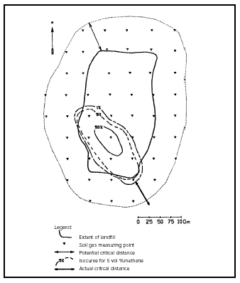
Figure 5.8
Illustration showing a method for identifying the gas-producing area at a
landfill.
Figure 5.8 illustrates an assessment based on the results of soil gas measurements for landfill gas. For a description of the survey method, please refer to Figure 4.1 with its explanatory notes in the subsection "Landfill gas" in Section 4.3.2.
Based on measurement results, Figure 5.8 displays isocurves for concentrations of 50, 5 and 1 per cent methane gas (by vol.). The gas-producing area is defined as the demarcated section where methane concentration in soil gas exceeds 1 per cent (by vol.) The actual risk distance for critical gas emission must be measured from the 1 per cent (by vol.) limit.
Gas production at a former landfill site will subside over time. Besides the amount of time elapsed since the specific disposal, source terms will depend on a number of factors. The most important factors are the composition of waste and the amount of waste. Appendix 5.1 provides an empirical calculation model for attaining estimations of the gas production rate and potential residual gas emissions (source term).
Assessments of the risk of explosion due to gas penetrating into buildings within the critical area are based on the source term and technical construction information regarding the building.
A distinction is made between buildings situated within and outside the gas-producing area.
In the case of buildings situated on top of the gas-producing area, the diffusive and convective contributions to indoor air may be calculated using the same sets of formulae described under Section 5.3.2.
Here, one must decide what "worst-case over pressure" is envisioned in the soil gas below the building. Intervals for measured values of over pressure at landfills are described in Table 1 of Appendix 5.2. In this table there are also empirical figures relating to air permeability and air porosity for various types of soil. Furthermore, there are values for the dynamic viscosity of air, methane and carbon dioxide.
In the case of buildings situated outside the gas-producing area, the risk assessment may be based on a worst-case scenario, which would entail containment of the surface, due to a prolonged period of freezing weather or precipitation for example.
For a building located at a given distance from the gas-producing area, the attenuation factor, i.e. the relationship between the indoor air concentration in the building and the soil gas concentration at the landfill in a state of equilibrium (dilution factors) may be calculated using the convection model described in Appendix 5.2.
Furthermore, calculations are made to establish the time needed to attain the pressure gradient and equilibrium concentration.
The indoor air concentration of methane, once established, should not exceed 1 per cent (by vol.), this being the typical alarm level for gas monitoring equipment. Besides providing an assessment as to whether the alarm level might theoretically be exceeded, the assessment must also address whether the worst-case scenario does in fact represent a realistic risk. This latter question may be assessed on the basis of the residual gas potential, cf. Appendix 5.1., and the time required for establishing equilibrium (equation 3 in Appendix 5.2).
5.4 Groundwater
5.4.1 General remarks on groundwater risk assessment
The purpose of a risk assessment is to evaluate whether a given instance of contamination of soil or of secondary groundwater contributes contamination to the primary groundwater to such a degree that the groundwater criterion for the contaminant in question is exceeded.
Performing a risk assessment and subsequently remediating if necessary, shall ensure that groundwater resources remain pure; i.e. that groundwater criteria are met. Thus, the ultimate goal is that water supply wells may be placed without restrictions and abstract pure groundwater. This will also ensure that the flow of groundwater to recipients remains pure.
Groundwater criteria have been set at levels ensuring that groundwater may be utilised as potable water after ordinary, traditional water treatment.
Before a risk assessment can be undertaken, it is necessary to collect various field data from soil and groundwater. These data are collated in the survey phase which forms the basis of the actual risk assessment. Several of the parameters that are to be determined may vary, even within very small distances, while others are more difficult to determine. Thus, use of regional data or text book data may be required.
Any risk assessment should be based on the precautionary principle. In other words, one should select conservative data and values - data which are on the safe side. In effect, this means that one should calculate more conservatively when the parameters used are estimates, when parameters are regional rather than local, or when, for other reasons, parameters are disputable. The more data available for the site in question, the less conservative the estimates need be. The precautionary principle entails that the result of a risk assessment will amount to an overestimation of the contamination risk, erring to the side which benefits the groundwater.
In conclusion, the characteristics of the soil and secondary groundwater contamination must be determined in order to determine the contribution to the primary groundwater.
Risk assessment is based on the principle that the groundwater zone containing the highest concentration must comply with groundwater criteria.
If the contaminants are also naturally occurring substances, as is the case with many metals, the natural background level must be included in the risk assessment. This means that the contamination contribution which stems from the soil contamination must be even less in order to ensure compliance with groundwater criteria.
If a second site is the source of xenobiotic contamination stemming from human activity, this concentration should not be included in the risk assessment. Contamination with xenobiotic substance from other sources than the site currently undergoing risk assessment is thus not to be considered.
A risk assessment must not be more lenient simply because the aquifer is already contaminated. Even where an aquifer is already heavily contaminated, and thus unsuitable for groundwater abstraction, it is unacceptable that contamination deriving from a new contamination incident does not adhere to groundwater quality criteria.
The objective of a risk assessment is to assess whether a given instance of soil contamination (or of secondary groundwater contamination) contaminates groundwater resources, or may be expected to contaminate such resources in the short or long term.
In this context, it should be noted that the groundwater quality criteria are independent of soil quality criteria, since adherence to soil quality criteria will not automatically ensure adherence to groundwater criteria (and vice versa); see also Section 6.6.
The background for carrying out a risk assessment will typically be investigations that have established a case of soil contamination, but have not established any contamination of primary groundwater.
The reason that no contamination of primary groundwater is ascertained may be that the investigations did not extend to the groundwater, thus making it undetermined whether it is in fact contaminated. In other cases, the reason may be that there have been no drillings to the groundwater in the most highly contaminated area; perhaps because of the inherent danger of further contaminating the groundwater during that process.
Also, wells drilled downgradient of the contamination may show non-contaminated groundwater or very low levels of contamination. On this basis, it cannot be ruled out that the contamination in question poses a risk. There is the possibility that the maximum source term has not yet been reached, or the well may not be situated in the contamination plume, since it is very difficult in practice to locate a contamination plume downgradient.
The result of a risk assessment of soil contamination may be supplementary investigations which can forming the basis for a subsequent, more extensive risk assessment before deciding whether remediation is needed.
Instances of contamination in secondary aquifers may be dealt with in a similar manner.
Leaching of contaminants from the contamination source, measured as flux (for example in kg of substance/year) is defined as the source term. The source term varies over time and place.
The source term concentration is the maximum concentration of contaminants (over time and place) released to the pore water from the contamination source.
The source term concentration is determined as follows:
| Measuring the concentration in pore water in the unsaturated zone immediately under the contaminated soil; e.g. in a conduit or tank pit. | |
| Utilising the contaminant’s maximum solubility. | |
| This requires, that the mass of contamination is of a certain size. In any case, the use of maximum solubility generally gives a gross over estimation of the source term concentration. | |
| In many situations, only the concentration of contaminants in the soil (or possibly in the soil gas) will be known. In these cases, the source term concentration is calculated based on an assumption regarding equilibrium between phase distribution in soil, water, and air (the fugacity principle), as described in Appendix 5.3. |
An example of such a calculation of the source term concentration can be found in Appendix 5.9.
A sudden release refers to a contamination pulse with a short duration, which is then brought to an end. In the unsaturated zone, an example of a sudden release might be a barrel that ruptures.
A continuous release refers to a contamination of large mass (in theory, of infinite mass) which therefore produces an continual stream of contamination. Examples of this could be a landfill, a major instance of soil contamination, or a leaking tank that is regularly refilled.
It should be noted that sudden releases in the unsaturated zone must often be considered a source of continuous release to the saturated groundwater zone. An example: a ruptured oil tank may result in a sudden release to the unsaturated zone; but the depth to the groundwater level will often require considerable time before the contamination front leaches to the saturated zone. As oil contaminants in leaching pore water also dissolve slowly, oil from such a ruptured tank will typically leach to the saturated groundwater zone over decades. Consequently, leaching of oil contaminants from a ruptured oil tank to the saturated groundwater zone must be regarded as a continuous release.
Primary aquifers are larger, interconnected aquifers of regional significance from which groundwater is or can be abstracted. In major parts of Zealand, the primary aquifers are limestone aquifers, which are often confined, while in Jutland, a considerable number of aquifers are in unconfined meltwater sand.
Secondary aquifers are secondary from the point of view of groundwater abstraction. Secondary aquifers are more shallow than primary aquifers, and are often unconfined.
In the context of the spreading of contamination and risk assessment, a secondary aquifer is given equal priority to a primary aquifer if significant spreading of contamination from the secondary to the primary aquifers and/or recipients is possible; or if the secondary aquifer is or can be used for water supply purposes.
If the concentration of a contaminant exceeds its maximum solubility, NAPL a separate phase known as a non-aqueous phase liquid (NAPL) will be present.
If contaminant concentrations which indicate presence of NAPL are found, there will, as a starting point, always be a risk. As a minimum, the NAPL should be removed. Risk assessment thus evaluate only dissolved contaminants.
When contaminants reach very large concentrations, the large differences in the density between the contamination plume and the surrounding, pure groundwater that the flow is directed by these density differences. The term used is for this is density flow. Density flow has been observed, for example, in the flow of NAPLs and the flow of landfill leachate.
The method that follows for stepwise risk assessment is not applicable to contaminants which spread by density flow.
A contamination risk is deemed to exist for groundwater if the final calculated resultant concentrations from the stepwise risk assessment exceed the groundwater criteria for the contaminant in question.
The contribution of contamination to a primary aquifer which results from a given soil contamination or from contamination in a secondary aquifer (and thus the calculated resultant concentration in primary aquifer), will depend on a number of factors which vary from site to site. The most significant factors are as follows:
| The contamination scenario, i.e. type of substance (mobility/degradability and other substance characteristics) as well as the contaminant concentration and area. | |
| Geology and hydrogeology, i.e. types of sediment (clay/sand/lime, organic content, hydraulic conductivity, effective porosity), net precipitation/groundwater recharge, groundwater gradient, pressure gradient between the secondary and the primary aquifer, as well as redox conditions. |
The following processes take place in the unsaturated as well as in the saturated zone and will lead to a reduction of the contaminant concentration in groundwater in the primary aquifer:
| Sorption: This effect is of particular relevance for sudden releases. In the case of larger-scale, continuous contamination release, the soil sorption capacity will gradually deplete around the waste site. |
In the risk assessment that is described in the following, sorption is taken into consideration only in the saturated zone (risk assessment step 3).
| Dispersion: As a direct process, this effect is of greatest significance for the saturated zone, since the flow velocity in the unsaturated zone is relatively low, approximately 0,25-2 m/year, while typical pore water flow velocity is on the order of 10-1000 m/year in the saturated zone. |
In the risk assessment that is described in the following, dispersion is taken into consideration only in the saturated zone.
As an indirect process, dispersion has significance for the transport time through the unsaturated zone. Because a major mechanism for contaminant removal can be biological degradation, where time is a crucial factor, dispersion will indirectly have a crucial influence on the removal of contamination.
| Natural degradation: is significant in the unsaturated as well as in the saturated zones, but is included in the risk assessment only in the saturated zone. |
Appendix 5.8 lists first-order degradation constants, which are considered to represent degradation under natural condition in Denmark.
In practice, locating a groundwater contamination plume is often difficult (even just tens of metres downgradient of the contamination source), which makes monitoring of the expected degradation very difficult in the saturated zone.
First-order degradation constants for the unsaturated zone are not yet publicised and well-documented methods for monitoring possible degradation are lacking.
5.4.2 Stepwise risk assessment method
Outlined below is a stepwise risk assessment of soil contamination, carried out with respect to an aquifer. The stepwise method of conducting a risk assessment has been designed to achieve a balance between the amount of data required from the contaminated site, and the complexity of the model. With small amounts of data, a simple model is applied, and with larger amounts of data, a more advanced model can be utilised.
A Step 1 risk analyses will produce a more conservative result than the other steps, even if the same basic data is used.
The stepwise risk analysis is illustrated in Figure 5.9. Steps 1 and 2 are conservative and simple methods which can be utilised even if only limited site-specific data from the contaminated site are available. Step 1 is a near-source mixing model, where calculations are based on the mixing of contaminant leaching from the unsaturated zone into the upper 0.25 m of the water table. Steps 2 and 3 assess the resultant contaminant concentration at greater distances from the contaminant source. Step 2 is a mixing model where the thickness of the mixing layer (dm) is calculated on the basis of dispersivity, pore water velocity, and mixing time. Step 3 is a mixing model like Step 2, but calculations take into account a reduction in the concentration of contaminants as a consequence of sorption, dispersion, and degradation in the saturated zone.
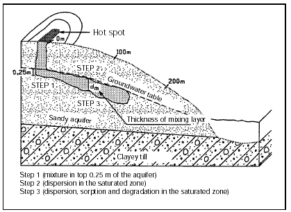
Figure 5.9
Illustration of risk analysis steps 1-3
In Step 3 of the risk assessment, sorption and degradation may be included in the calculations. It is not possible, however, to identify a degradation constant or a sorption coefficients for substance mixtures, such as engine oil or petrol. In these cases, it is necessary to make calculations without sorption and degradation for the substance mixture. Sorption and degradation may then be included in the calculations for a specific environmentally harmful substance, i.e. a substance with the slowest degradation rate, lowest groundwater quality criteria, and lowest sorption constant in relation to the actual concentration. Since the concentration of specific substances in a mixture is a significant factor for the selection of the most environmentally harmful substance, general guidelines can not be formulated.
Examples of specific use of the stepwise risk assessment can be found in Appendix 5.7.
5.4.2.1 Step 1. Near-source mixing model:
In near-source risk assessment, the resultant contaminant concentration in groundwater is calculated immediately under the area of contamination.
The conservative calculation which is used, assumes that the pore water at the bottom of the unsaturated zone has a concentration of contaminants which is equal to the concentration at source. After this, the calculation assumes that the contamination is mixed in the upper 0.25 m of the aquifer (if the aquifer thickness is less than 0.25 m’s, the actual thickness is used).
Step 1 of the risk assessment does not account for sorption, dispersion and degradation. It is assumed that the aquifer is homogenous and isotropic.
Calculation of the content of contaminants in groundwater is performed as a mass balance for the upper part of the aquifer. The concentration of contaminants C1 in the upper part of the aquifer is (cf. Appendix 5.6):
| A.N.C0 + B.0.25[m].k.i.Cg | |
| C1 = | |
| A.N + B.0.25[m].k.i | |
where:
C0 is the concentration at the source [ML-3],
Cg is the natural background content of contaminants in the groundwater [ML-3],
A is the size of the contaminated area [L2],
N is the net infiltration [LT-1],
B is the breadth of the contaminated area (calculated in relation to the direction of groundwater flow) [L],
k is the aquifer’s hydraulic conductivity [LT-1], and
i is the hydraulic gradient [unitless].
Specific examples of performing risk assessments can be found in Appendix 5.7. Examples of standard data, including typical values for hydraulic conductivity k, can be found in Appendix 5.8.
The resulting contaminant concentration in the upper 0.25 m of the saturated zone can also be determined directly through analysis of groundwater collected from a screen (with a length of 0.25 m) placed at the top of the aquifer. In connection with the risk assessment, the highest of the measured concentrations should be used.
When using measured concentrations, it is important to make a judgement as to whether the case involves a sudden release to the groundwater (which has been discontinued) or a continuous release (or a release which takes place over an extended time period) which gives a contribution to contamination of the groundwater aquifer. If groundwater is to be measured, it is a prerequisite that the maximum concentration has already reached the groundwater and that the front of contamination is not on its way through the unsaturated zone, resulting in higher concentrations at a later date.
The local geology must be known well enough to place the monitoring well in an optimal location. The placement of the well should avoid problems such as sloping layers or impermeable layers which may result in a significant part of the contaminants being transported away from the monitor well.
One should be aware that construction of a well with a 0.25 m screen requires precise knowledge of the location of the groundwater table, since the screen otherwise will not be placed correctly. In practice, this means that the groundwater table must be measured in existing wells. A well with a screen length of only 0.25 m will be very vulnerable with respect to variations in the water table. Such a well can therefore only be counted to be useful for the calculation of the source term at the time of construction, and will most often not be useful for subsequent monitoring.
Screens with an interval greater than 0.25 m can be used to measure the resulting contaminant concentration in the top of the aquifer if sampling takes place with a very low yield so that no significant cone of depression is formed.
If a screen with an interval of greater than 0.25 m is used, the resulting contaminant concentration C1 in the aquifers upper 0.25 m shall be calculated by:
C1 = C1, meas � l/0.25 m
where C1, meas is the measured contamination concentration [ML-3] and l is the effective screened interval (measured in metres).
In the formula for calculating the resultant contaminant concentration C1, a constant concentration ,C0, at the source of contamination is assumed for the entire contaminated area.
If it is justified by the investigation phase, the contaminated area can be divided into areas which each have a different area-weighted source term concentration.
For contamination over large areas, calculations can concentrate on contamination in a central area, cf. the principle that the zone with the highest concentration in the groundwater must comply with the groundwater quality criteria.
All parameters in the calculation participate linearly, i.e. uncertainties in the value of one parameter has the same impact as uncertainties in another parameter.
The greatest uncertainty will often be in determining the hydraulic conductivity and the source term concentration.
There will be some uncertainty in defining net infiltration (cf. Appendix 5.8, regional values for net precipitation are often used), and the hydraulic gradient (which can be read on regional potentiometric surface maps, or which can be determined during the investigation phase, in which case the interpolation method between points (linear interpolation, etc.) affects the result).
The least uncertainty is often connected with determination of the area and breadth of the contaminated area.
5.4.2.2 Step 2. Downgradient mixing model:
Description
The conservative calculation which is used, assumes that the pore water at the bottom of the unsaturated zone has a concentration of contaminants which is equal to the concentration at source. After this, the calculation assumes that the contamination is mixed in the upper part of the aquifer.
The resultant concentration of contaminants is calculated for a point at a distance from the pollution source which corresponds to one year of groundwater flow (calculated with the pore-water velocity of the groundwater); though maximum 100 m. At this theoretical calculation point, the groundwater quality criteria must be met.
In the saturated zone, a thickness of the mixing layer, dm, is used (cf. Appendix 5.6):
dm = ( 72/900 . aL . vp . t) -0.5
where
aL is the longitudinal dispersivity [L],
vp is the pore water velocity [LT-1], and
t is the groundwater flow time; t has a maximum of 1 year as the theoretical calculation point is located at a distance which corresponds to 1 year’s flow distance.
If the actual thickness of the aquifer is less than 0.25 m, the actual thickness is used.
Calculations are carried out in a manner analogous to calculations in Step 1 of the risk assessment. The concentration of contaminants, C2, in the upper part of the aquifer will be (cf. Appendix 5.6):
| A.N.C0 + B.dm.i.Cg | |
| C2 = | |
| A.N + B.dm.k.i | |
C0 is the concentration at the source [ML-3],
Cg is the natural background content of contaminants in the groundwater [ML-3],
A is the size of the contaminated area [L2],
N is the net infiltration [LT-1],
B is the breadth of the contaminated area (calculated in relation to the flow direction)
[L],
dm is the mixture depth in the aquifer at a given distance [L],
k is the aquifer’s hydraulic conductivity [LT-1], and
i is the hydraulic gradient (unitless).
If the contaminant concentration C1 in the upper 0.25 m of the groundwater aquifer in the near-source model (step 1) is measured, and subsequently corrected for screen length (if necessary), this can be used for a simple calculation of the downgradient contaminant concentration, C2.
In the actual point of calculation, the resulting contaminant concentration C2 can be expressed by:
C2 = C1 � (0.25 m/dm)
where
C1 is the resulting contamination concentration [ML-3] in the upper 0.25 m of the saturated zone at the contamination source,
dm is the thickness of the mixing layer after 1 year’s groundwater transport, though maximum 100 m downgradient of the contamination. If the thickness is less than 0.25 m, then dm = 0.25 m is used.
5.4.2.3 Step 3. Downgradient risk assessment with dispersion, sorption, and degradation
In the third step of the risk assessment, the resultant concentration of contaminants in the groundwater is calculated taking dispersion, sorption and degradation into account. Step 3 is a continuation of step 2, since the starting point for step 3 is the resulting contaminant concentration, C2, which was calculated in step 2.
The resultant concentration of contaminants is calculated as in Step 2 of the risk assessment, at a point located at a distance from the contamination source, which corresponds to the groundwater flow distance in one year (calculated with the pore water velocity of the groundwater); but up to a maximum of 100 m. At this theoretical calculation point, the groundwater quality criteria must be met.
As previously mentioned, the step 1 and 2 risk assessments are conservative. The step 3 risk assessment cannot be carried out strictly conservatively. Where degradation is used in the calculations, monitoring should be carried out.
It is assumed that the saturated zone is homogenous and isotropic with constant groundwater velocity. In the saturated zone, degradation and vertical dispersion are taken into account. Degradation is assumed to be described by first-order degradation. Calculations are carried out based on typical first-order degradation constants, which are not necessarily conservative.
In order to use a step 3 risk assessment, the local geology and hydrogeology must be so well-known that sampling and monitoring screens can be placed in optimal locations (vertically as well as horizontally) in the contaminant plume and on a flow path downgradient of the contamination source. In addition, it is assumed that the contamination investigation has shown that the redox conditions give a possibility for the degradation of the contaminants of interest. It is thus assumed that the contamination does not contain recalcitrant contaminants in concentrations above groundwater quality criteria (for example, MTBE in a petrol contamination) and that in the theoretical calculation point, concentrations of potential degradation products also meet groundwater quality criteria.
When the above assumptions are met, the risk assessment should be carried out using first order degradation constants, which are typical for the relevant redox zone. The starting point for the calculation is the resulting contaminant concentration which was calculated in step 2. If the risk assessment shows that the groundwater quality criterion is not met even though natural attenuation is taken into account, the contamination then presents a risk. A new risk assessment may be performed, if new site-specific data is obtained from supplemental investigations.
On the other hand, if the risk assessment shows that the groundwater quality criterion is met, monitoring shall be carried out in order to ensure that degradation and redox conditions are as expected. In addition, monitoring shall provide data which can be used as a basis for calculating a site-specific degradation constant.
On the basis of first-order degradation, the resulting contaminant concentration after degradation, C3, can be expressed by the following formula /56/:
C3 = C2 � exp(-k1 � t)
where
C2 is the resulting contaminant concentration calculated in the downgradient mixing model (step 2) [ML-3],
k1 is the first-order degradation constant in the saturated zone [T-1],
t is the time period within which degradation takes place [T].
Sorption can be taken into account in order to assess the length of the time period during which contaminants are liable to be degraded. This is done by assuming that contaminants are transported to the theoretical calculation point with a velocity Vs which is given by
Vs = Vp / R, R > 1
The effect of sorption is that the contaminants require more time (more than one year) to reach the theoretical calculation point, and that more time is therefore available for degradation to take place in.
The so-called retardation coefficient R is defined in appendix 5.6 Retardation coefficients are dependent on the soil’s bulk density, the soil’s content of organic matter and the octanol-water distribution coefficient.
An overview of the parameters used for the calculations in the various steps of a risk assessment are shown in figure 5.10.
Where degradation is taken into account, the first-order degradation constant and the degradation time are the most sensitive parameters in calculating the resulting contaminant concentration. These parameters participate exponentially in the calculation of the resulting contaminant concentration while precipitation and the measured contaminant concentration in the top 0.25 m of the aquifer, for example, are participate only linearly in the calculation. A small change in the first-order degradation constant (or degradation time) can therefore result in a large change in contaminant concentration.
Calculation parameter |
Step where calculation parameter is used |
|||||||||
Measured contaminant concentration in pore water |
|
|||||||||
Relative volume of air, Vl |
|
|||||||||
Relative volume of water, VV (= water-saturated porosity eW) |
|
|||||||||
Relative volume of soil, Vj |
|
|||||||||
Soil temperature, T |
|
|||||||||
Particle density of soil, d |
|
|||||||||
Concentration of contaminant in soil, CT |
|
|||||||||
Soil density, r |
|
|||||||||
Soil content of organic matter, fOC |
|
|||||||||
Partial pressure of contaminant, P |
|
|||||||||
Molecular weight of contaminant, m |
|
|||||||||
Gas constant, R |
|
|||||||||
Solubility of contaminant in water, S |
|
|||||||||
Octanol-water distribution coefficient, KOW |
|
|||||||||
Longitudinal dispersivity, a L |
|
|||||||||
Net precipitation, N |
|
|||||||||
Hydraulic conductivity, k |
|
|||||||||
Hydraulic gradient, i |
|
|||||||||
Area of contamination, A |
|
|||||||||
Breadth of contaminated area, B |
|
|||||||||
Effective porosity, eeff |
|
|||||||||
1st order degradation constant in the saturated zone, k1 |
|
|||||||||
Natural background content of contaminant in groundwater, Cg |
|
|||||||||
Measured concentration of contaminant at the top of the aquifer, C1, meas |
|
|||||||||
Effective screen length, l |
|
Figure 5.10
Calculation parameters involved in Step 1-3 of the risk assessment. The letters a-d
refer to the different methods through which the contaminant concentration at the top of
the aquifer is determined.
- Determination of the source term concentration using measured concentrations in pore water.
- Source term concentration determined by the fugacity principle in porewater.
- Source term concentration is set equal to the solubility.
- Measurement of contaminant concentration at the top of the aquifer.
Redox processes are decisive for whether a substance degrades and how it degrades /13, 56/. The amount of energy obtained from various redox processes are vary different. Therefore, a thermodynamic order of processes can be set up reaching from aerobe processes which have the greatest energy output, through a variety of anaerobe processes, and ending with methanogene processes which have the smallest energy output.
In the saturated zone, development of redox sequences is often observed downgradient of a severe contamination. The most reducing conditions (for example, methanogene conditions) are found closest to the source of contamination where the concentration of organic matter is the greatest, whereas oxidising conditions (aerobe or nitrate-reducing conditions) are found at the edge of the contaminant plume, where the concentration of organic matter is low.
In order to chose the relevant degradation constant, it is therefore important to be aware of the redox conditions.
Aerobe conditions are present if the O2 concentration in the groundwater is greater than 1 mg/l. Definitions of the various anaerobe redox zones, however, is more ambiguous. The anaerobe redox zones are in general characterised by the following:
| there is an increase in the hydrogen content (H2) throughout the entire anaerobe zone | |
| in the nitrate-reducing zone, the concentration of nitrate (NO3-) decreases | |
| in the iron-reducing zone, the concentration of Fe(III) decreases and the content of Fe(II) increases | |
| in the sulfate-reducing zone, the sulfate content (SO42-) decreases | |
| in the methanogene zone, methane (CH4) is produced. |
In a technology project, the Danish EPA has tabled first-order degradation constants, which are judged to be representative for Danish conditions /56/.
Often, few or no degradation constants can be found for specific redox conditions. Where publicised constants are found, these tend to vary greatly in value.
BTEXs, some chlorinated solvents and phenol are the only contaminants where there is a useful set of data making it possible to identify typical first-order degradation constants. The order of magnitude of degradation constants for these contaminants is found in appendix 5.8.
As mentioned earlier, step 3 of the risk assessment is not strictly conservative. Where the risk assessment shows that natural attenuation of the contaminants in groundwater can cause the groundwater quality criterion can be met, monitoring shall take place to ensure that the calculated concentrations in the monitoring wells is not exceeded. In addition, the actual redox conditions at the site shall be determined and data which can be used as a basis for calculating a site-specific degradation constant shall be obtained.
In connection with this monitoring, it is of greatest importance that the extent of the contamination and the groundwater flow is thoroughly mapped since monitoring will take place in wells which are located downgradient of the contamination along a flow line.
The exact placement of a monitoring point, the number of monitoring points analytical parameters and monitoring period depend on the contaminants composition and the hydrological conditions and must therefore be assessed in each specific case. Investigation wells may in some cases be used for monitoring purposes.
Methods for documenting that degradation actually takes place is given in the literature /56, 57, 58/. To carry out these methods, a number of chemical analyses are need as a supplement to the typical data which is used in cases where the risk assessment is simply based on mixing. Content of the contaminants and possibly of degradation products must be analysed for. In addition, analyses and field measurements which describe the redox conditions must be carried out.
An example of how degradation of benzene can be determined is given in appendix 5.7.
As a minimum, three wells along a flow line (in addition to wells which are used to map the flow direction and the extent of contamination) are required, see figure 5.11. As a minimum, monitoring will typically be carried out twice a year for three years.
It should be noted that the monitoring wells should be placed relatively close to the source of contamination (at a distance of less than one year’s groundwater transport), where there is the greatest possibility of an optimal placement in relation to the contaminant plume.
If concentrations exceeding the groundwater criterion are observed outside the calculated contaminant plume (upgradient or sideways) or at a greater downgradient distance than one year’s groundwater transport, a new risk analysis based on additional data must be carried out, or one must conclude that the contamination presents a risk for the groundwater resource.
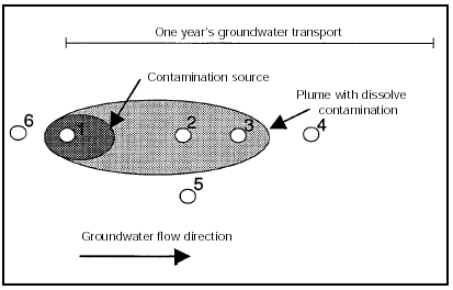
Figure 5.11
Example of the placement of investigations/monitoring wells in relation to a
contamination /56/.
If degradation takes place more slowly than expected, a new risk assessment with the actual site-specific degradation constant shall be carried out.
When the actual site-specific degradation rate is to be determined from the monitoring data, measured contaminant concentrations must be corrected for the effects of sorption, dispersion and dilution. This can be done by comparing the concentration of the contaminant of interest with the concentration of a conservative compound (tracer) or by comparing a slowly-degradable compound in the contaminant with the easily-degradable contaminant of interest.
One easy method is to use a non-degradable compound in the contaminant as a tracer. If a slowly-degradable compound is used as a tracer rather than a non-degradable compound, a more conservative degradation constant results.
A description of how a non-degradable organic compound can be used as a tracer is found in appendix 5.6. An example of the use of an slowly-degradable organic compound as a tracer is found in appendix 5.7.
5.4.2.4 Numeric computer models:
There are numerous computer models available with varying calculation possibilities and bases for calculations. It is important to know the model’s basis for calculation (the equations on which calculations are based) as this can determine which assumptions must be used for the calculations.
One advantage of computer models is that they do not require that estimates be made, but are capable of performing numerical calculations. Also, such models can handle large volumes of data.
Numeric computer models can therefore perform calculations using many horizontal layers, and with horizontal variations in the properties of the material.
However, in order to benefit from the numeric models, large amounts of data are required. It is therefore often expensive and time-consuming to conduct risk assessments using computer models.
5.5 Surface-water recipients
Groundwater discharge and - in special circumstances - surface run-off of contaminated water can affect surface water recipients such as streams, lakes, and coastal areas.
Calculation of the adverse effect of contaminants on a recipient is based on the same principles mentioned in connection with groundwater contamination.
General guidelines for the quality of water in recipients are laid down in the Recipient Quality Plans, drawn up by county councils.
Based on the objectives for the recipients, county councils lay down specific limit values for discharges. County councils must ensure that, as a minimum, discharges comply with the relevant requirements in statutory orders and guidelines /47, 48, 49, 50, 51, 52/.
Variations in mobility and physical/chemical/biological conditions imply that, as a rule, the parameters which are critical for an aquifer are different from the parameters which are critical for a recipient.
For example, a small hydrocarbon spill may have no impact on a well-protected aquifer. On the other hand, a direct surface run-off of even small amounts of oil to a nearby pond will be unacceptable.
Surface-water run-off to a recipient can occur if:
| The recipient is located in the immediate proximity of the site. | |
| The topography and run-off conditions in the area make surface-water run-off possible |
For contamination via normal surface-water run-off (during a rain storm or a sudden thaw), contamination will primarily comprise contaminant bound in the upper soil layer. Therefore, to assess this effect, results of analyses of topsoil samples are used.
With respect to surface water run-off, it is rarely possible to judge the size of the effect on the recipient.
The recipient can only be contaminated through groundwater discharge if groundwater flows from the site to the recipient. Recipients located at a higher level than the site are therefore without risk.