Establishment of a basis for administrative use of PestSurf
4 Results and discussion
- 4.1 Data interpretation in PestSurf
- 4.2 Main conclusions for each pesticide
- 4.3 Summary of concentrations generated by the three models
- 4.4 Patterns observed in PestSurf
- 4.5 Distribution of the contribution to groundwater
The section includes a description of the general data interpretation in PestSurf, followed by a presentation of results from the scenario simulations. The results are presented in three ways in the following chapters. First, the summaries from the annexes concerning each pesticide are included. Secondly, the general trends from the comparisons between FOCUS SW and PestSurf simulations are described and thirdly, the patterns observed for each PestSurf scenario are outlined.
4.1 Data interpretation in PestSurf
The PestSurf result files consists of concentration levels for each stored timestep in each calculation location. The stream models contain 133 calculation points in the sandy catchment and 72 in the sandy loam catchment. The pond models only contain three points each within the pond. The simulations cover 2 * 4 years and data are saved every 10 minutes (or less) the first two hours after spraying, every hour up to 30 days after spraying and every day for the rest of the simulation.
Data can be extracted concerning the concentration of active substance in the water phase, the concentration on suspended matter, the concentration on colloids and the concentration on macrophytes. These concentrations are given as µg/m³ (equal to ng/l), and is calculated per m³ of water column. As there is no supply of suspended matter during the simulation and only very small amounts of colloids, the two items are of no interest in the simulations.
For all substances, there is a close correlation between the concentrations in the water phase and the concentration in macrophytes. The macrophyte concentration is assumed constant in the ponds and vary over the year in the streams (scaled with a factor 0-1[1]). The maximum concentration of biomass in the water is calculated to be 33 g/m³ for the sandy pond, 875 g/m³ for the sandy loam pond, 276 g/m³ for the sandy stream and 1380 g/m³ for the sandy loam stream. The concentration of active substance in the biomass can be obtained by dividing the concentration given for active substance on macrophytes in µg/m³ water column with the concentration of biomass present at the particular time. Furthermore, the concentration of pesticide is calculated for the pore water and the sediment. The porewater concentration is in µg/m³ porewater. The sediment concentration is shown in MIKE View as µg/m³, but the correct unit for the sediment concentration is µg/g, a unit that is not available in MIKE View.
The concentration of active substance in pore water is determined by diffusion. The sediment layer is 2 cm in the stream and 10 cm in the ponds. Sediment concentrations and porewater concentrations show the same pattern, and the amount of adsorbed pesticide is calculated as a function of the porewater concentration.
The concentration in the porewater is limited by diffusion. In reality, the concentration will be higher in the very top of the sediment,. The highest value can be found by calculating the sediment concentration in the very top of the sediment in a layered sediment model. Data are reported for the top 2-cm of sediment in both streams and ponds. In FOCUS, the reporting depth for sediment is 5 cm.
In PestSurf, the description of diffusion into sediment differs between the stream and pond models. A “single sediment layer” is used for the stream, while several layers are used in the ponds. When extracting sediment and pore water data from the ponds, it should be noted that the multilayer model used is associated with every other calculation point. For the pond, data can be extracted in the upstream end (0) or the downstream end (25 or 40 m, depending on which pond). Data regarding porewater concentrations and pesticide sorption to sediment is extracted at the end of the pond.
The aim of the data analysis in this study was to obtain a description of the occurrence of the active substance in time and space within the catchment. For each PestSurf simulation, the maximum values for all locations were extracted and a number of time series were selected, representing the maximum values. Typically, maximum values were obtained on different dates and/or times for different locations. Longitudinal profiles were extracted to show the concentration pattern on a particular day with occurrence of a maximum. The yearly maximum was extracted for each of the eight simulation years, and for the total simulation and averages were calculated for 1 hour (if the storage steps allows it), 1, 2, 4 and seven days.. PestSurf result presentation templates, which present data for pre-defined points, were evaluated and compared to the results for all locations. Details of each simulation is given in Annex 1-12.
The PestSurf scenarios will be refered to as sandy or sandy loam stream or pond, whereas the FOCUS-SW scenarios will be refered to as D3-ditch for the sandy scenario and D4-stream and D4-pond for the sandy loam scenario.
4.2 Main conclusions for each pesticide
Maximum actual water and sediment concentrations for the twelve pesticides are recorded in Table 4.2 and Table 4.3. The concentration in macrophytes and the ratio between pesticide in the macrophytes and in the water phase is shown in Table 4.4.
4.2.1 Alphacypermetrin
FOCUS SW and PestSurf generally agree that drift is an important source for alpha cypermethrin. However, groundwater contributes significantly to the concentration levels in the sandy pond and the sandy loam stream. The high groundwater table around the sandy pond in the undrained sandy soil leads to very fast transport from the surface to the top of the groundwater table, which again is in direct contact with the pond. For the sandy loam stream, the lower part of the stream is in contact with a sand layer that receives water from the upstream part of the catchment. A groundwater contribution is not included in FOCUS SW.
The sandy scenarios are not quite comparable for the two models. The concentrations generated by PestSurf for the two sandy scenarios are lower for the pond and higher for the stream than what is generated for the D3-ditch. As the pond is less exposed to drift than the ditch, the concentration difference is expected.
For the stream, the high concentration is caused by the fact that the whole catchment is sprayed within 30 minutes. This assumption is the determining factor for the result. The maximum concentration is reached about 1 km from the top end of the catchment. Further down dilution, and in some places presence of buffer zones, lead to lower concentrations.
For the point of maximum concentration, the following calculation was carried out: The dose is 15 g/ha, and the percentage calculated to enter the stream is 1.85 % of the dose. The resulting amount is 27.7 µg/m². The water depth at the time of spraying is 8.2 cm, but the cross section is triangular at this point, meaning that the average depth is 4.1 cm only. If the water was stationary and not flowing, the concentration would reach 0.68 µg/l. The maximum concentration reached is 0.41 µg/l. The resulting concentration at a given location becomes a balance between concentration in the inflow and outflow, and the addition in the given point.
If the concentrations are extracted 112 m from the upstream end of the sandy catchment (approximately the same distance from the top as the data extraction point in the FOCUS D3 ditch scenario), the concentration only reaches 37 ng/l, which is about 1/3 of the concentration in the D3 ditch. However, the concentrations are not directly comparable. At this point, the stream is protected by a 20 m buffer zone. The dose is therefore about 14.7 times lower than in the D3-ditch. The water depth, however, is only about 5 cm.
The sandy loam pond may be compared to the D4-pond-scenario. The concentration levels are comparable. In the PestSurf sandy loam pond 2/3 of the active substance in the water phase is sorbed to macrophytes, but the higher amount of substance can be explained by the fact that the PestSurf pond is considerably smaller than the FOCUS SW-pond (250 m² against 900 m²) and therefore more exposed. A rough estimate of the exposure is to assume that 20 m is sprayed in PestSurf sandy loam pond and 30 m in a FOCUS SW-pond. The dosis is then diluted in 250 and 900 m³, respectively: 20/250/(30/900) = 2.4. When comparing the two systems, it should be noted that part of the load on microphytes appear to stay in the pond from year to year.
The concentration in sediment is low in both models, but considerably lower in PestSurf than in FOCUS SW.
For the upstream part of the sandy loam catchment, the concentration of 560 ng/l generated by PestSurf is considerably higher than the concentration generated for the FOCUS D4-stream (79 ng/l), particularly when taking into account that the concentration is halved by macrophytes. The reason is again the assumption that all agricultural land is sprayed within 30 minutes, with a wind direction perpendicular to the stream. The maximum concentration in the upper part of the catchment is reached after 1425 m of the stream. On the following stretch, the concentration is lowered by additions of drainage water and the presence of bufferzones, but even higher concentrations (1.36 µg/l) are reached towards the end of the catchment, along a stretch that is also susceptible to wind drift.
Because the concentrations in the sandy loam catchment are so much higher than in the D4-catchment, a detailed evaluation of the longitudinal pattern of high concentrations was carried out. Evaluating from the upstream end, the concentration first increases and then decreases twice due to the tributaries Albjergbaek and Steensbaek. The concentration increases again and drops strongly around 1000 m from the upstream end due to the tributary Elholt baek. Just after 1700 m, a buffer zone of 20 m is present, leading to a drop in concentrations. This is followed by buffer zones of 10 and 3 m. The tributary Fredligbaek enters around 2400 m from the upstream end and Groftebaek around 2600 m from the upstream end.
The maximum concentrations generated by drift were then evaluated. The maximum reachable concentration should be the concentration obtained if the water was standing in the river strech.
Table 4.1. Maximum concentrations for drift calculated by PestSurf and assuming stationary conditions.
Tabel 4.1. Maximum-koncentrationer for drift beregnet med PestSurf og under forudsætning af stationære forhold.
| Location | Max concentration ng/l |
Water depth cm |
Cross section | Max concentr. calc. for stationary conditions. |
| OL 290 | 607 | 4.0 | Triangular | 1586 |
| OL 625 | 569 | 6.8 | Triangular | 925 |
| OL 1425 | 560 | 9.5 | Triangular | 668 |
| NL 330 | 625 | 6.4 | Triangular | 991 |
| NL 495 | 657 | 5.3 | Triangular | 1197 |
| NL 847 | 1065 | 7.3 | Triangular | 868 |
| NL 1279 | 1355 | 9.7 | Triangular | 729 |
The high concentrations found at the end of the catchment become higher than the theoretical considerations allow. No good explanation could be found for the up-concentration found at the end of the catchment, see discussion in chapter 4.3 and 4.4.3.
The concentration 125 m from the upstream end of the sandy loam catchment becomes 518 ng/, and is still higher than the 79 ng/l generated in the FOCUS SW D4-stream scenario, especially when the presence of macrophytes are considered. However, the water depth at the time of maximum is only 4.3 cm, and this accounts for most of the difference between the models. The maximum concentration on the stretch, where the stream is permanent and upstream of the groundwater influence is 583 µg/l, 855 m from the upstream end.
Macrophytes (Table 4.4) are significant in all scenarios, but particularly in the sandy loam catchment. Macrophytes are not included in the FOCUS scenarios.
Assuming that the drift contribution to the stream is overestimated, drainage events may be of interest in the sandy loam catchment. The 20-year event causes concentration of about 1.4 ng/l in the upstream part of the catchment, and the (overestimated- see section 2.1) groundwater contribution causes concentrations around 136 ng/l in the downstream part of the catchment, about one 6th of the maximum concentration caused by drift.
4.2.2 Bentazon
The sandy pond generates lower concentrations than the D3-ditch, which produce lower concentrations than the sandy stream. The sandy pond is influenced by groundwater, while the D3 ditch and stream are mainly influenced by drift, although the stream receives some drainage contribution.
The major reason for the high stream concentration of 39.3 µg/l is the fact that a very long stretch of water is sprayed at the same time. The theoretical maximum for a stationary situation in the point of maximum concentration reaches a concentration of 55.5 µg/l. If the concentration is extracted 112 m from the upstream end of the sandy catchment, it only reaches 1.89 µg/l, compared to 9.95 µg/l reached in the D3-ditch. However, this is a result of a difference of exposure of due to presence of 20 m wide buffer zones along this part of the stream (a factor of 14.7) and a water depth at the time of spraying of about 9-10 cm at the time of spraying.
The concentration of the D4-pond is about 30 % higher than for the sandy loam pond. Both ponds are mainly influenced by drainage. The fact that more soil types and groundwater levels are present in PestSurf, probably results in the lower concentration level.
The concentration in the sandy loam stream is 106 µg/l compared to 8.25 in the FOCUS D4-stream. Both values are generated by drift. With the same reservation on the maximum value as mentioned for alphacypermethrin, the maximum concentration on the stretch, where the stream is permanent and upstream of the groundwater influence is extracted. It is 51.6 µg/l, 625 m from the upstream end.
For the sandy loam catchment, the concentration 125 m from the upstream end is 55.3 µg/l, and thus still much higher than the 8.25 µg/l found in the FOCUS D4-stream. The water depth at this stretch is about 4.5 cm. The difference in water depth thus explains the difference in concentrations.
The macrophytes do not excert a strong influence on the concentration in the water phase in any of the scenarios scenarios due to the low potential for adsorption of bentazon.
With respect to sediment concentrations, all of the concentrations generated by PestSurf are lower than the concentrations generated by FOCUS SW.
Table 4.2. Summary of results regarding the concentration of pesticide in water from the 98 simulations. Comparable scenarios are highligted with the same colour.
Tabel 4.2. Sammenstilling af resultater af pesticidkoncentration i vand fra de 98 beregninger. Sammenlignelige scenarier er mærket med samme farve.
Table 4.3. Summary of results regarding the Sediment concentrations from the 98 simulations. Comparable scenarios are highligted with the same colour.
Tabel 4.3. Sammenstilling af resultater af pesticidkoncentration i sediment fra de 98 beregninger. Sammenlignelige scenarier er mærket med samme farve.
Table 4.4. Concentration in macrophytes compared to the concentration in the water phase. The extremely high values for pendimethalin are caused by extremely high and permanent concentrations in the water phase.
Tabel 4.4. Koncentration I makrofytter sammenligned med koncentrationen I vandfasen. Den ekstremt høje værdi for pendimethalin skyldes en ekstrem høj og permanent koncentration i vandfasen.
4.2.3 Bromoxynil
The concentration generated by PestSurf for the sandy pond is about 40 % of the concentration generated by FOCUS SW D3-ditch, while the concentration in the sandy stream is 3-4 times higher. The reason for the high concentrations in the stream is the simultaneous spraying of the total agricultural area. The maximum concentration level is reached 1111 and 1049 m from the upstream point, for the spring and autumn-applications, respectively. 112 m from the upstream end, the concentrations are 83 and 234 ng/l for the spring and autumn-application. These concentrations are considerably lower than the concentrations found in the D3-ditch (759 and 1143 ng/l). However, the concentrations cannot be compared directly because the top end of the PestSurf sandy catchment is protected by 20 m bufferzone. The water depth at the time of spraying is 14 and 9.5 cm for the spring and autumn-application time respectively, 112 m from the upstream end.
For the sandy loam pond, PestSurf generates a concentration that is about three times as high for the spring application and 12 times as high for the autumn application. For this particular autumn application, the water depth is only 21 cm (a factor 5), while the water depth for the spring application is 76 cm (a factor 1.3). A basic difference between the FOCUS D4-pond and the PestSurf sandy loam pond is the size, 900 m² against 250 m², which means that the PestSurf sandy loam pond is more exposed to wind drift. A rough estimate of the difference in exposure is a factor 2.4.
For the sandy loam stream, the PestSurf-concentrations are 10 and 18 times higher than the concentrations generated by FOCUS SW, for the spring and autumn applications, respectively. As for the sandy stream, this is due to the simultaneous spraying of the whole agricultural area and very limited water depth at the time of spraying, particularly for the autumn application during a dry autumn, where the water depth varied between 3 and 9 cm over the stream. The maximum value is reached near the end of the catchment. 125 m from the upstream end, the maximum concentration is 3990 and 7188 ng/l, with a corresponding water depth of 4.8 and 3.5 cm. Taking the difference in water concentration into account, the concentration levels correspond quite well. The maximum concentration on the stretch, where the stream is permanent and upstream of the groundwater influence is 3.13 µg/l and 7.74 µg/l, 625 m from the upstream end.
All maximum concentrations are generated by drift in both models Macrophyte concentration do not have a significant influence on the concentrations in the water phase in any of the scenarios, since bromoxynil has a low logKow. The sediment concentrations are very low in PestSurf for all scenarios, and considerably lower than the ones calculated in the FOCUS SW-scenarios. The concentrations correspond to the concentrations in the porewater, which are governed by the diffusion coefficient, and therefore also by the duration of high concentrations in the water phase.
4.2.4 Fluazinam
The concentrations generated by PestSurf differ considerably between catchments and scenarios. The concentration generated for the sandy pond and stream are much larger than for the FOCUS SW D3-ditch. The reason for the high pond concentration is the addition of fluazinam through the groundwater. For the sandy stream, the continuous spraying of a long stretch together with a limited water depth causes the high concentrations. The maximum concentration reached 112 m from the upstream end of the sandy stream is 370 ng/l, and this value is more comparable to the 614 ng/l found for the D3-ditch. In PestSurf, however, the stretch is protected by a 20-m buffer zone, causing a reduction in the dose of a factor 13.6[2]. The water depth at the time of spraying is about 7 cm. Part of the difference is due to the smaller dose used in the FOCUS SW-simulations for compounds with several applications.
The sandy loam pond and the FOCUS D4-pond is within a factor of 3.3 of each other. However, the sum of the concentration in macrophytes and in the water phase is 1471 ng/l. More solute is thus present in the PestSurf pond than in the D4-pond. One reason for the difference is the difference in size between the two ponds: 250 m² against 900 m² and the difference in water depth during the summer period. For this particular compound, the PestSurf pond receives more pesticide than the D4 pond, because FOCUS SW reduces the load per application when more applications per year are practised.
For the sandy loam stream, the maximum concentrations are generated by the 20-year event for most of the catchment. The maximum value is much larger than what is generated by FOCUS SW. A similar situation is not present in the FOCUS SW- scenarios. 125 m from the upstream end is a point with a maximum value caused by drift. The maximum value here is 5380 ng/l, which is considerably higher than the FOCUS value of 497 ng/l. The water depth in the PestSurf point at the time is only about 5 cm at the time of spraying, but the additional difference could be due to the reduction in drift dose with more application times in FOCUS SW (approximately 50% reduction).
In the downstream end of the sandy loam catchment, the effect of spraying long stretches becomes important. At the same time, the high concentrations occurring in the lower part of the sandy loam catchment are also caused by contributions from groundwater flow. Fluazinam has a a relatively high DT50 value, meaning that pesticide percolated below the plough layer degrades very slowly. However, as mentioned earlier (Section 2.1), the transport to groundwater is considered to be overestimated by the model (fluaziam is fairly strongly bound to soil particles and transported through macropores).
The highest concentration in the sandy loam catchment is reached in a tributary and is due to the 20-year-event. The water depth in June, at the time of spraying, is generally in the range of 5-8 cm.
Macrophytes influence all scenarios significantly, but particularly the sandy loam stream and pond. The concentrations in the water phase are strongly influenced and reduced by the presence of macrophytes.
The concentration in sediment in the sandy pond is considerably higher than in the D3-ditch, which is a function of the higher water concentration and the very long exposure time. Most of the simulation has water concentrations above 2 µg/l. For the sandy loam pond scenario, the sediment concentration is lower than in the corresponding FOCUS SW-scenario. Although the maximum water concentration is higher in the sandy loam loam pond than in the FOCUS D4-pond, it is still much lower than in the sandy pond and do not lead to similar sediment concentrations.
The groundwater buildup of active substance means that the concentration in the water phase is high for a long period of time and this influences the sediment concentration. As a result, the sediment concentration in the sandy loam stream is slightly higher than the concentration in the D4-stream.
The highly different conditions warrant an evaluation of what is more realistic. First of all, potatoes cannot be grown on the same piece of land year after year. The idea of spraying all agricultural land 8 years in a row with a compound used for potato is therefore not realistic. The high concentration found in the sandy pond is, as mentioned earlier, not so realistic because of the undrained conditions. The concentration in the sandy stream, however is realistic, assuming that a long streach of stream is sprayed.
The sandy loam pond is realistic too with respect to its physical description. For the sandy loam stream, the 20-year event included in the simulation has taken place, and as drainage contributions were quite well simulated during the calibration phase, it is, as such a realistic event. It occurs already in the first year of simulation and no strong buildup in groundwater concentrations have taken place at this time.
The groundwater concentration is exaggerated though. To avoid this influence it is recommended to extract values between 500 m and 1700 m from the upstream end. In this case, the value is 18.9 µg/l, and caused by drainage. Generally, the flow conditions and water depths used in FOCUS are not representative for 1. order stream systems in Denmark, particularl taking into account the catchment size they are supposed to represent.
4.2.5 Malathion
For malathion, the mechanism generating the maximum concentrations is drift in all instances. The concentrations generated for the sandy pond is smaller than the concentration generated for the D3 ditch, which again is smaller than the concentration in the sandy stream. The reason for the high exposure for the sandy stream is the accumulation of wind drift over a long stretch of the stream. 112 m from the upstream end, the maximum concentration generated is 1.96 µg/l, a value that is much more comparable to the concentration in the D3 ditch (4. 61 µg/l). The values are not directly comparable as the sandy stream is protected by a 20 m buffer zone along the stretch. The value is thus a combination of a reduced drift dose (a factor of 14.7) and a water depth of 7 cm.
The concentration in the sandy loam pond is higher than in the D4-pond due to its higher exposure and a water depth of about 70-cm at the time of spraying.
Compared to the FOCUS SW-stream-scenario for D4, the concentration level in the sandy loam stream is considerably higher (81.4 µg/l compared to 3.92 µg/l). A value of 31.3 µg/l is reached already 125 m from the upstream end. The water depth at this point is between 3.6 and 4.85 cm at the time of maximum concentration. The water depth alone thus causes a factor of >7 compared to the FOCUS concentration. Furthermore, the PestSurf stream does not have a square cross section as the FOCUS streams. The cross section at the upstream end are triangular. The maximum concentration reached on the streach 500 m to 1700 m from the upstream end is 35.0 µg/l, 625 m from the upstream end.
The FOCUS D4-stream reaches a sediment concentration of 168 ng/kg while the PestSurf sandy loam stream only reaches a concentration of 8 ng/kg, in spite of the much higher water concentrations.
Macrophytes have a limited influence on the concentration in the water phase.
4.2.6 Metamitron
All maximum concentrations are generated by drift in the FOCUS SW-scenarios while in PestSurf, the maximum concentration for the sandy pond is generated by groundwater contributions.
The concentration in the sandy pond is smaller than the concentration in the D3 ditch, which again is smaller than in the sandy stream. For the pond, this is mainly due to lower exposure. For the stream, the higher concentration is due to the spraying along the whole stream within 30 minutes. 112 m from the upstream end of the stream, the concentration only reaches 0.590 µg/l, considerably less than the 3.67 µg/l reached further in the FOCUS SW D3-ditch. The difference is due to protection from a 20 m buffer zone. The water depth at the time of maximum concentration is 12.5 cm.
The D4 pond (149 ng/l) and the sandy loam pond (0.355 ng/l) differ in concentration level due to differences in pond characteristics. The difference in concentration is very close to a factor of 2.4, as explained in section 4.1.
With respect to the sandy loam stream, the concentration is considerably higher in the PestSurf simulation than in the D4-stream (44.9 µg/l compared to 3.05 µg/l). This is due to spraying along a long stretch of the stream and the very small water depth present at the time of spraying. 125 m from the upstream end, a maximum concentration of 23.1 µg/l is found. The corresponding water depth is around 5 cm. The maximum value on the 500-1700 m streach is 21.6 µg/l.
Macrophyte adsorption is low and does not play a role for the final concentration in the water phase.
As for most of the other compounds, the sediment concentrations are higher in the FOCUS –scenarios are higher than in the PestSurf-scenarios. To judge the effect of the sorbed amounts on the water concentration, the amount per square meter can be calculated: For the D4-stream, the sediment concentration is 0.149 µg/kg. In 40 kg sediment[3]/m2,, the total amount is 5.96 mg. In the water phase, the concentration is 3.047 µg/l, in 300 l/m², resulting in 914 mg. The pesticide in sediment thus has a limited influence on the concentration in the water phase.
4.2.7 Pendimethalin
The application rate for the autumn application is four times higher than for the spring application. This causes drift contributions to differ between the spring and autumn scenarios in all instances.
Macrophytes significantly influence the water concentration in most simulations, and most strongly in the sandy loam stream.
The sandy pond has lower concentrations than the D3-ditch, which has lower concentrations than the sandy stream. The concentration in the stream is strongly influenced by wind drift, due to the fact that the whole agricultural area is sprayed within 30 minutes. This causes very high concentrations. 112 m from the upstream end the spring and autumn-concentrations are 0.357 and 4.076 µg/l, both of which are lower than the D3-ditch concentrations of 2.51 and 10.1 µg/l respectively. It is clearly noticeable, that while the spring- and autumn-concentration in the D3-ditch differ by almost exactly a factor 4, the concentrations generated by pestSurf differ more, due to mixing in different amounts of water. The low concentrations at the top end of the sandy catchment is caused by a buffer zone of 20 m, combined with a water depth of 12.4 cm and 7 cm for the spring and autumn application, respectively.
The concentration in the sandy loam pond can be compared to the concentration in the D4-pond. The concentration in the PestSurf sandy loam pond is highest, and the difference is caused by the greater exposure (a smaller pond) and for the autumn application, a difference in water level at the time of spraying.
The concentrations in the sandy loam stream are very high (153 and 337 µg/l for the spring and autumn application, respectively), and much higher than what is found in the D4-stream (2.07 og 8.65 µg/l, respectively). For both applications in PestSurf, the highest concentrations are found in the lower end of the catchment and are caused by a baseflow contribution. A high DT50 value causes accumulation of pesticide in the aquifer, and the water drains to the stream. The amount leaching to the aquifer is judged as unrealistically high, and so is the sorption to macrophytes in this case. For the autumn application, the winddrift takes place at the same time as the high concentrations occur due to the baseflow contribution, resulting in even higher concentrations in the stream. In the upstream part of the sandy loam catchment, the concentrations also become high, 14.4 and 58.6 µg/l, respectively, 125 m from the upstream end. This is due to wind drift into a small flow of water (about 6 cm depth). The high concentration during autumn is due to a four times higher application dose at this time of year.
Extracting the maximum concentration on the stretch 500-1700 m from the upstream end, where the baseflow concentration is avoided, the maximum concentration reached is 13.9 and 67.5 µg/l. These figures are caused by drift and are explainable based on water depth, flow, cross section and length of the stream sprayed.
Sediment concentrations generated by PestSurf are lower in all cases, even when the concentrations in the water phase are considerably higher than what is generated by FOCUS SW.
4.2.8 Propiconazol
For the sandy conditions, the PestSurf sandy pond generates lower concentrations than the ditch, which again generates lower concentrations than the stream. The global maximum value calculated by PestSurf for the sandy catchment in the water phase is 3.42 µg/l compared to 0.792 µg/l in the D3-ditch scenario. The high concentrations reached are a function of the simultaneous spraying of all agricultural land within 30 min. However, 100 m from the upstream end, the concentration reached in PestSurf is 0.245 µg/l, which is more comparable to the D3-ditch. These values are, however, not directly comparable as the top end of the sandy stream is protected by a 20 m buffer zone. The water depth at the time of maximum concentration is about 7 cm.
Compared to the FOCUS SW D4- pond the concentration levels generated by PestSurf are higher; 171 ng/l compared to 30 ng/l. The ponds differ in size, and that factor alone accounts for part of the difference. The difference in water depth accounts for the rest. The fact that the pond evaporates during the summer leads to an increase in concentration, which is not seen in the FOCUS simulations.
The FOCUS SW D4-stream-scenario for generates a concentration of 0.657 µg/l, while the PestSurf simulation reaches 11.8 µg/l. In both simulations, the maximum concentrations are generated by wind drift. The maximum concentrations in PestSurf are reached because a long stretch of stream receives drift simultaneously. 125 m from the upstream end, a concentration of 4.46 µg/l is reached. The water depth at this time is only about 5.2 cm, and the cross section is triangular. There is therefore a factor of 11.5 hidden in the difference in water depth and shape. The maximum concentration reached on the stretch from 500 to 1700 m from the upstream end is 5.02 µg/l.
The macrophyte concentrations were in all cases small compared to the concentration in the water phase.
Sediment concentrations are systematically lower in PestSurf than in FOCUS SW.
4.2.9 Prosulfocarb
The concentration in the sandy pond is lower than for the D3 ditch, which is lower than for the sandy stream. The high concentration in the sandy stream is caused by simultaneous spraying of all agricultural areas within 30 minutes. The concentration 112 m from the upstream end reaches 6.50 µg/l, which is more comparable to the 15.2 µg/l found in the D3-ditch. The PestSurf concentration is, however, caused by a combination of a reduced dose due to a buffer zone of 20 m and a water depth of 6-7 cm.
The FOCUS SW-scenario D4-pond generates a concentration of 0.524 µg/l, which is considerably lower than the PestSurf sandy loam pond-concentration of 4.17 µg/l. The water depth at the time of maximum concentration is 23 cm. The difference in exposure and depth accounts for a factor of about 10, and the difference between the two models is therefore justified.
Compared to the FOCUS SW D4- stream-scenario, the maximum concentration of PestSurf is much higher, 235 µg/l compared to 13.1 µg/l. The highest concentration reached in both models are caused by drift. The very high concentrations are caused by simultaneous spraying on the total agricultural area within 30 minutes. If the concentration is evaluated 125 m from the upstream end, the concentration reaches 88.0 µg/l. The water depth at the time of spraying is below 3.4 cm. The maximum concentration reached between 500 and 1700 m from the upstream end is 102 µg/l.
Macrophytes do influence the concentrations but only to a small extent. The concentrations in sediment are substantially lower than what is calculated by FOCUS SW.
4.2.10 Rimsulfuron
The concentration in the sandy pond is lower than for the D3-ditch, which is lower than for the sandy stream. The ditch-concentration is caused by wind drift, while the concentration in the sandy pond is caused by groundwater contribution. The sediment concentrations also differ, PestSurf reaching 1.8 ng/kg while FOCUS reaches 1.4 ng/kg. In both cases the figures are small.
The concentration in the sandy stream is strongly influenced by the fact that the whole agricultural area is sprayed within 30 minutes. This results in high concentrations. The maximum concentration reached 112 m from the upstream end is 64 ng/l, which is less than what is found in the D3 ditch (159 ng/l). The low concentration in PestSurf is, however, due to a combination of a buffer zone of 20 m width and a water depth of about 7 cm.
The concentration in the sandy loam pond is 22 ng/l, compared to 12 ng/l in the D4-pond. This difference can be explained by the difference in exposure between the ponds in the two systems.
Compared to the FOCUS SW-D4-stream, the maximum concentration of PestSurf is higher, 2.35 µg/l compared to 132 ng/l. The highest concentrations reached is caused by drift in both models, but drainage after the 20-year rain event does cause high concentrations to occur in PestSurf. The maximum concentration reached 125 m from the upstream end is 909 ng/l. The water depth at the time of spraying is about 4.5 cm, and the depth difference between the two models thus explains most of the difference. In addition, the PestSurf stream is triangular. The maximum concentration reached between 500 and 1700 m from the upstream end is 1.01 µg/l.
Macrophytes play a minor role for the concentration in the water phase in the sandy scenarios, but the role is significant for the sandy loam scenarios, because the concentration of macrophytes is considerably higher here than in the sandy scenarios.
Sediment concentrations are low in all simulations, but always higher in the FOCUS SW scenarios than in the PestSurf scenarios.
4.2.11 Terbutylazin
The maximum concentration reached for the D3-ditch is lower than the concentration reached for the sandy pond and for the sandy stream. The concentration reached in the D3-ditch and the sandy stream is caused by drift, while the concentration reached in the pond is caused by shallow groundwater. The high concentration reached in the sandy stream is caused by spraying of the total agricultural area within 30 minutes. However, 112 m from the upstream end, the concentration is only 695 ng/l in the sandy catchment, and thus considerably lower than in the D3-ditch scenario (2.62 µg/l). The difference is, however, due to a combination of a bufferzone of 20 m width and a water depth of 8-9 cm.
The concentration reached in D4-pond and the sandy loam pond are of the same level of magnitude. Both concentrations are reached during the drainage season and are caused by drainage contributions to the pond.
The concentrations reached in the D4 stream and the sandy loam stream are considerably different. PestSurf generates a maximum concentration of 32.1 µg/l compared to 2.28 µg/l generated by FOCUS SW. The highest values in PestSurf are found downstream where both a build up in groundwater concentrations and drift contributes. The buildup in groundwater is not represented by FOCUS SW. The same goes for the extreme rainfall event and the high concentrations seen in the upstream part after a dry summer. These events generate high- but not the highest concentrations. 125 m from the upstream end of the sandy loam catchment, the concentration reaches 15.8 µg/l. The corresponding water depth is about 4 cm. This difference explains the difference found between the two models.
With respect to the sediment concentrations, the concentration reached in the sandy pond is considerably higher than the concentration reached in the D3-ditch (6.72 compared to 0.864 µg/kg). Also for the sandy loam stream, the sediment concentration is much higher (6.56 µg/l) than the concentration reached in the D4-stream (1.86 µg/kg). However, for the sandy loam pond, the sediment concentration is lower (0.694 µg/kg) than for the D4-pond (2.13 µg/kg). If the maximum concentration is evaluated on the stretch between 500-1700 m, the maximum concentration is 15.5 µg/l.
The models differ substantially due to presence or absence of macrophytes. Particularly for the sandy loam pond and stream, the concentrations in the water phase are influenced by the presence of macrophytes.
4.2.12 Tribenuron
The concentrations generated for the sandy pond and stream are about a factor 3 higher than the concentrations generated for the FOCUS SW D3-ditch. The pond is influenced by groundwater, while the D3-ditch and the sandy stream are influenced by wind drift. The high concentration generated in the stream is caused by the fact that the total agricultural area is sprayed within 30 minutes. However, 112 m from the upstream end, the concentration only reaches 10 ng/l, which is considerably less than what is found in the D3-ditch (95 ng/l). The low concentration in PestSurf, however, is due to a combination of a 20 m wide buffer zone and a water depth at the time of maximum concentration of 13-14 cm.
The FOCUS SW D4-pond and the PestSurf sandy loam pond differ by a factor of 3. The diffence is caused by the higher exposure of the sandy loam pond and a lower water level during the dry year of the simulation.
With respect to the D4-stream and the sandy loam stream, FOCUS SW generates 76 ng/l while PestSurf generates 747 ng/l. Both models generate the maximum concentrations through wind drift. However, some drainage contribution does take place in the sandy loam stream. The high concentrations in PestSurf are generated due to accumulation of drift contributions along the stream. 125 m from the upstream end, the concentration reaches 553 ng/l. The water depth at the time of maximum concentration is around 4.8 cm. This, and the fact that the PestSurf stream is triangular, accounts for the difference between the two models.
The maximum value obtained between 500 and 1700 m from the upstream end is 390 ng/l.
Macrophytes influence the concentrations, particularly in the sandy loam pond, but to some extent also in the sandy loam stream.
With respect to sediment concentrations, the maximum value generated by FOCUS is 11 ng/kg and the maximum value generated by PestSurf 3.1 ng/kg. PestSurf values are consistently lower than the FOCUS-SW-values but both models results in low sorption values.
4.3 Summary of concentrations generated by the three models
The water concentrations generated by the different models “direct spray, ” “drift”, FOCUS SW and PestSurf, are shown in Table 4.2. The method generating the highest concentrations is “direct spray” as expected, except for the spring application of pendimethalin in one PestSurf scenario. The FOCUS scenarios always generate lower concentrations than the drift calculations with a minimum buffer zone. For the ponds, this is clearly due to dilution. For the ditch and stream, it is likely to be due to a smaller dose, as the average contribution over a meter of water body is less than the contribution just at the edge and because the water is flowing. For four compounds, the PestSurf sandy pond generates higher concentrations than the corresponding drift calculation (fluazinam, pendimethalin autumn appl, terbutylazin and tribenuron methyl). For the sandy loam pond, all PestSurf simulations generate values that are lower than the drift calculations.
For the Pestsurf sandy stream and sandy loam stream, PestSurf generates higher concentrations than the drift calculations for all pesticides. The highest concentrations in the simulations are always generated in the PestSurf sandy loam stream.
While the maximum concentrations for the simple calculation methods and in the FOCUS SW-scenarios are related to a water depth of 30 cm (or 1 m in a pond), a maximum concentration in PestSurf is related to the actual water depth for the particular waterbody at the time of spraying, in some cases only a few cm.
The FOCUS SW-D3 ditch is not entirely comparable to the two sandy scenarios in PestSurf, while the sandy loam pond and stream must be judged to be comparable.
The maximum concentrations occurring in comparable water bodies may not be generated by the same type of process. In Table 4.5, the processes generating the maximum concentrations are listed. The highest concentration in the D3- ditch is always caused by drift. This is also always the case for the sandy stream. However, for compounds with low sorption, transport to groundwater may take place in this scenario. Bentazon, rimsulfuron and tribenuron methyl have low Koc-values. The first two are transported to groundwater in this scenario, while tribenuron methyl with the lowest DT50-value of the three seems to degrade.
For the PestSurf sandy pond, where solute transport takes place through (very) shallow groundwater, transport in groundwater is the dominating mechanism. Drift plays a role if the degradation is very fast, such as for malathion. For bromoxynil, the relatively high sorption and the fast degradation rate interacts to make drift an important source. For alphacypermethrin, the sorption and small dose play a role. As this compound degrades slowly, it will tend to build up in groundwater. For the FOCUS SW-scenarios, groundwater does not transport pesticide. Drift also play a role for Prosulfocarb. This is mainly due to the fact that it is applied during periods with little water (10 cm ) in the pond at the time of spraying.
The FOCUS D4 stream receives almost all its major contributions from drift. For the first set of simulations of the PestSurf sandy loam stream scenario (where drift was underestimated), this was only the case in case of malathion, because the fast breakdown makes leaching almost impossible. For the upper part of the catchment, drift played a role for alphacypermetrin and to some extent for bromoxynil, but drainage was by far the dominating cause of high concentrations. For several of the compounds, the highest concentration, particularly in the upstream part of the catchment, was generated by an extreme (20-year return period) precipitation event. The event is not important to malathion due to the fast degradation, and to prosulfocarb due to the spraying date, which is about a week after the extreme event. For bromoxynil it seems to be a combination of the low DT50 and the time of spraying (April) or the autumn-application (October) that makes the extreme event less important. Similarly, tribenuron has a low DT50, is sprayed in April and is not dominated by the extreme event.
However, with the correction of the model code, drift became the dominating factor in most of the sandy loam stream-simulations. Only for fluazinam, the extreme event still dominates the upstream part of the catchment.
FOCUS SW does not include events of comparable severity and the importance of the event in administrative judgements must be considered with a view to the return period, which is “1in 20 years”.
In the lower part of the catchment, a contribution through groundwater becomes important for all substances with a DT50 value greater than 56 days. As described in Styczen (2004a), it is believed that the buildup in groundwater is exaggerated in the model due to the description chosen for the macropores. However, occurrence of ”old” pesticides in baseflow is a known phenomena, and the spraying of 85-90 % of the catchment area eight year in a row will cause a buildup of groundwater concentrations if the substance leaches in important amounts. FOCUS SW assumes that baseflow is free of pesticide and only contributes to dilution of the concentrations in the water body.
Table 4.5. Cause of the simulated maximum concentration. Comparable scenarios are highligted with the same colour.
Tabel 4.5. Årsag til den simulerede maximumskoncentration. Sammenlignelige scenarier er vist med samme farve.
Table 4.6. Comparison between concentrations generated before and after change in code. The yellow colur indicate the combinations, where the primary source creating the highest concentration has changed from groundwater or drainage contributions to drift. The ratio between the maximum concentrations generated in the second and the first simulation is indicated in the table.
Tabel 4.6. Sammenligning mellem koncentrationer genereret før og efter ændringen I modelkode. Den gule farve viser de kombinationer, hvor den primære årsag til høje koncentrationer er ændret fra grundvandstilførsel til drift. Forholdet mellem maximums-koncentrationerne genereret i anden og første simulering er vist i tabellen.
After the change in code, drift and the groundwater contribution co-operates in creating the highest concentrations for fluazinam and autumn-applied pendimethalin. For Alphacypermethrin, propiconazol and terbutylazin, the drift contribution is much more important than the groundwater contribution. For spring-applied pendimethalin, the highest concentrations are caused solely by the groundwater contribution.
For all other pesticides, drift is the dominating source after the change in code.
As shown in Table 4.5, the drift results on the lower part of the sandy loam stream are not fully explainable, and it was not possible without a rather large effort to identify whether it is due to an instability in the setup or an unwanted interaction with the sand layer in the lower part of the stream. As the problem is only found at this particular stretch, it is expected to be linked to the model setup and not to the software code as such. As the same stretch suffers from the unrealistically high concentrations from groundwater, it is recommended to extract data from the upper 1700 m of the stream only (see also section 4.4.3).
Table 4.6 shows a comparison between the concentration levels simulated before and after the change in code in PestSurf. In the first case, wind drift was severely underestimated. However, in the second set of simulations, the amount of drift appears to be seriously overestimated in the stream scenarios, because the whole stream receives drift within a period of 30 minutes. The scenarios, where the cause of the maximum concentration has changed from drainage or groundwater concentration to drift concentration are indicated with yellow in the table. Even if the assumptions regarding drift are changed, concentrations will not become lower than the concentrations generated by drainage or groundwater contributions.
For the sandy stream, concentration levels would be strongly influenced by a change in drift assumptions, while for the sandy pond, only three of the scenarios are significantly influenced. For the sandy loam stream, the ratio between the concentrations generated in the first and second simulation range from 1 to 1566, for a case where groundwater totally dominates to a case where drift totally dominates. All other cases have ratios between 1.2 and 429. For the sandy loam pond, five scenarios have changed status. For propiconazol, however, the concentrations are generated by a combination of drift and drainage.
The concentration levels of the sandy loam pond calculated by PestSurf and the FOCUS SW-D4-pond show reasonable correspondence. In nine of the fourteen cases, both scenarios are dominated by drift. In three cases, drainage is the dominating process for both models. Only in two of the fourteen cases there is a discrepancy between the causes of the highest concentrations, which FOCUS SW consider drainage and PestSurf drift. In both cases, drainage is also a source in PestSurf, and it should be considered that the PestSurf pond is more exposed to drift than the FOCUS SW ponds.
In Figure 4.1, the sandy loam pond concentrations (D4-pond and PestSurf sandy loam pond) are compared. PestSurf generates consistently higher concentrations than the FOCUS SW-D4-pond. However, the points fall in three groups, that is maximum concentrations generated by drift, by drainage, and two points, where the causes are mixed. When the concentrations are generated by drainage, the model simulations are in the same order of magnitude. When drift is the dominating factor, the PestSurf concentrations are higher than the D4-pond concentrations. The three points on or to the left of the trendline are all autumn-applications and are influenced by a low water level in the pond. The values to the right of the trend line are spring applications, and here the major reason for difference is that the FOCUS ponds are 900 m² and thus less exposed than the sandy loam pond of 250 m².
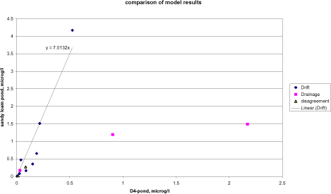
Figure 4.1. Comparison between the FOCUS SW- and PestSurf simulations for the D4- and sandy loam ponds. PestSurf generates generally higher concentrations than FOCUS SW. The points are divided according to the cause of maximum concentration.
Figur 4.1. Sammenligning mellem FOCUS-SW- og PestSurf-simuleringer af D4- og morænelersvandhullet. PestSurf genererer generelt højere koncentrationer end FOCUS SW. Punkterne er opdelt efter årsag til maximumskoncentration.
Figure 4.2 shows a similar plot for the sandy loam stream. Pendimethalin stands out with the two values high above the indicated line caused by a build-up of the concentration in groundwater. Fluazinam, with a PestSurf-generated concentration of 26 µg/l (occurring in a tributary) caused by the extreme drainage event, also appears above the line. Four differences between the models explain the difference in simulation results: 1. The area sprayed in the sandy loam catchment covers 82 % of the catchment compared to 20 % in the D4-stream. 2. The concentrations generated by drift in the FOCUS-simulations represent 100 m of stream, and not the full lengt of the catchment as in PestSurf. 3. The water depth in the stream is frequently much lower than 30 cm, and 4. no groundwater contribution is included in the FOCUS-SW-simulations.
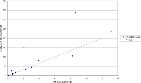
Figure 4.2. Comparison between the FOCUS SW- and PestSurf simulations for the D4- and sandy loam stream.
Figur 4.2. Sammenligning mellem FOCUS SW- og PestSurf-simuleringer af D4- og morænelersvandløbet.
Figure 4.4 shows a similar comparison based on the maximum concentrationobserved between 500 and 1700 m from the upstream end of the sandy loam catchment. The upper 500 m are excluded to avoid dry periods, see section 4.4.3. The only outlier observed is fluazinam, where the concentration is generated by the 20 year event rather than drift.
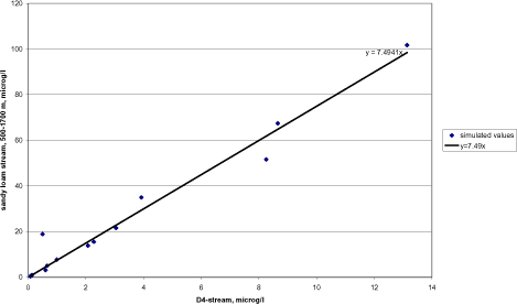
Figure 4.3. Comparison between the FOCUS SW- and PestSurf simulations for the D4- and sandy loam stream between 500 and 1700 m from the upstream end.
Figur 4.3. Sammenligning mellem FOCUS SW- og PestSurf-simuleringer af D4- og morænelersvandløbet mellem 500 og 1700 m fra den opstrøms ende.
The FOCUS SW D3-ditch is compared to the sandy pond in Figure 4.4 and to the sandy stream in Figure 4.5. The pond is dominated by entirely different mechanisms and there is a poor correspondence between the two simulations. With respect to the stream, there is an almost linear correlation, but the concentration levels generated by PestSurf are about 4.3 times as high as the concentrations generated in the D3-ditch. For the stream, the agricultural area sprayed is about three times the area sprayed for the D3-ditch, but the flow is much larger and part of the stream is protected by buffer zones. At the same time, the stream receives drift contribution along its entire length within 30 minutes. The contribution thus adds up compared to the FOCUS scenario, where only 100 m of stream or ditch is sprayed.
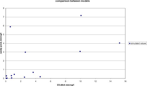
Figure 4.4. Comparison between the FOCUS SW D3-ditch and the PestSurf simulation for the sandy pond.
Figur 4.4. Sammenligning mellem FOCUS SW-D3-grøften og PestSurf-simuleringer af det sandede vandhul.
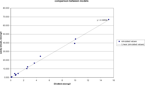
Figure 4.5. Comparison between the FOCUS SW D3-ditch and the PestSurf simulation for the sandy stream.
Figur 4.5. Sammenligning mellem FOCUS SW D3-grøften og PestSurf-simuleringerne for det sandede vandløb.
Macrophyte sorption depends on Kow, and the compounds with the highest Kow-values does show the highest macrophyte sorption. However, the comparison in Table 4.4 is obscured by the fact that the reported maxima are not necessarily happening at the same time or the same place, and a direct comparison of the two is therefore not always meaningful. Macrophyte sorption is always higher in the sandy loam scenarios than in the sandy scenarios due to a higher presence of macrophytes.
With respect to sediment concentration, attention was given to the fact that PestSurf systematically calculate lower concentrations than FOCUS. The explanation is not straight forward. As mentioned in section 2.1, the stream models differ as the PestSurf sediment is made up of one compartment, while FOCUS streams have several sediment compartments. The diffusion coefficient is identical in the two models. For the ponds, the sediment layer is described by a number of compartments in both models. The diffusion coefficient used in PestSurf is higher than the one used in TOXWA and determined from experiments carried out in an earlier project (Helweg et al. 2003). The findings of this project were that only traces of pesticides were found in the sediment in a pond with macrophytes. Without macrophytes present, the compounds (fenpropimorph and pendimethalin) were measurable in sediment. Kronvang et al. (2003) measured pesticide in sediment for the two streams. No pesticides were found in sediment above the detection limit in the sandy stream. In the sandy loam stream, five of the pesticides included in these simulations were also included in the analyses (alpha-cypermethrin, malathion, pendimethalin, propiconazol and terbutylazin), but only alpha-cypermethrin was detected. The concentration appear high, 3 and 6 ng/g dry weight – however, 10 ng/g DW is stated to be the detection limit for alpha-cypermethrin in sediment in the same study. With a detection limit of 10 ng/g DW, all simulated sediment concentrations are below detection limit.
In practice, macrophytes thus appear to lower the concentration in sediment, and in general, concentrations found in sediment are low.
The transport of pesticide from the water body to the porewater, which is in contact with the sediment, is described by an equation that, apart from the diffusion coefficient, also contain a boundary layer. It was attempted to change the parameter by a factor of 100 in PestSurf to evaluate the effect, but without a visible result on sediment concentration. It is not clear from the FOCUS SW-report what depth a boundary layer has in the FOCUS-scenarios.
4.4 Patterns observed in PestSurf
The following sections is a summary of the information given in Annex 1-12, for each of the PestSurf water bodies. The summary concentrates on the concentrations in the water phase of the waterbodies. Macrophyte concentrations, pore water and sediment concentrations generated by PestSurf are described in the Annexes.
4.4.1 Sandy catchment, stream
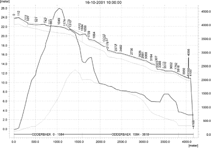
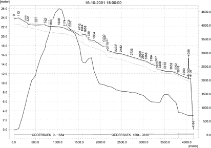
As listed in Table 4.5, high concentrations in the sandy catchment is typically caused by drift. A typical time series for a specific location in the stream is shown in Figure 4.6. The concentration varies from top to bottom of the catchment as shown in Figure 4.7. The longitudinal plots show the concentration as a thin black line. The thick black line shows the maximum concentrations reached in each location during the whole simulation period. Furthermore, the stream bottom and the two sides of the stream are indicated on the figure.
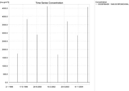
Figure 4.6. Concentration pattern over time for the autumn application of bromoxynil in the sandy catchment, 1049 m from the upstream end. (µg/m³ = ng/l)
Figur 4.6. Koncentrationsmønster som function af tid for efterårstildelingen af bromoxynil I det sandede opland, 1049 m fra den opstrøms ende. (µg/m³ = ng/l)
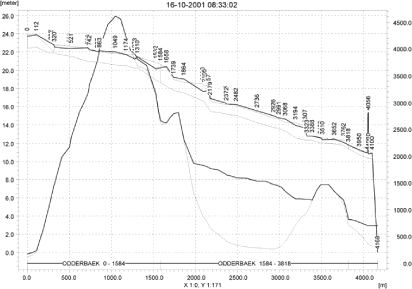
Figure 4.7. Concentrations (ng/l) of autumn-applied bromoxynil in the sandy catchment on 16. October 2001, just after spraying (thin black curve). The thick black line shows the maximum concentrations reached at each location for the total simulation period. Furthermore, the stream bottom and the two sides of the stream are indicated on the figure.
Figur 4.7. Koncentrationer (ng/l) af efterårstildelt bromoxynil in det sandede opland den 16. oktober 2001, lige efter udsprøjtning (tynd sort kurve). Den tykke sorte kurve viser maximumskoncentrationer opnået ved hver lokalitet for hele simuleringsperioden. Herudover er åbunden og de to åbrinker indikeret på figuren.
The middle section of the catchment is protected by natural buffer zones. The highest concentrations in the middle of the catchment are reached when the high concentrations from the upstream end move downstream, see Figure 4.8.
In the lower end of the catchment, drift enters the stream, but the amount of water is higher, and causes dilution.
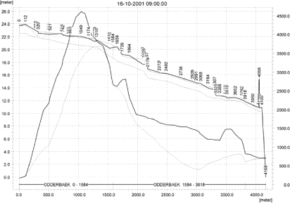
The duration of the drift peaks differ depending on the amount of water in the stream and sorption by macrophytes, but Figure 4.8 shows a typical example of the change in concentration over time. Clearly, the duration of an event is longer in the lower part of the catchment than in the upper part, if the whole stream receives drift at the same time. For the shown event, it takes about 8-10 hours from the spraying begins before all pesticide has left the catchment.
a)
b)
c)

d)
e)
f)
g)
Figure 4.8. Concentration (ng/l) of autumn-applied bromoxynil over time after a spray event in the sandy catchment. Spraying starts at 8.00, finishes at 8.30, and concentration levels are shown at 9.00, 10.00, 11.00, 12.00, 14.00, 16.00 and 18.00. Figure 4.7 show the concentration at 8.33 for the same event.
Figur 4.8. Koncentration (ng/l) af efterårstildelt bromoxynil som funktion af tid efter udsprøjtning i det sandede opland. Udsprøjtningen begynder kl. 8.00, afsluttes kl. 8.30, og koncentrationsniveauer er vist kl. 9.00, 10.00, 11.00, 12.00, 14.00, 16.00 og 18.00. Figur 4.7 viser koncentrationen kl. 8.33 for den samme udbringning.
Only two compounds display a sightly different pattern – bentazon and rimsulfuron. The results of the bentazon simulations are shown in Figure 4.9. In this case, the concentration pattern in the stream is influenced by drainage and groundwater contributions. The highest contributions are obtained in connection with the high-rainfall winter 1998/99 (which is identical to 2002-3) and the following season.
Table 4.8 lists the locations generating global and local maxima. Due to the fact that drift is the dominating cause of high concentrations in the sandy catchment, many of the locations are identical from simulation to simulation.
Table 4.9 shows the relative concentration levels at the different local maxima. However, the local maximum points were generally not selected in the first version of the PestSurf Excell presentation template and the concentrations generated by the tool are generally lower (producing maximum concentrations of about 0.55 of the true maximum). In Table 4.7 the global maxima and the maxima found for the pre-defined locations in the Excell result extraction tool are compared.
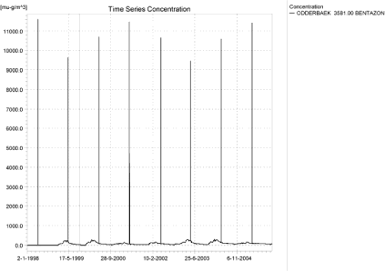
Figure 4.9. Concentration pattern over time for bentazon at the bottom of the sandy catchment (µg/m³ = ng/l).
Figur 4.9. Koncentrationsmønster som function af tid for bentazon nedstrøms i det sandede opland (µg/m³ = ng/l).
Table 4.7. Comparison between maximum values generated by the result extraction tool and the global maximum generated by PestSurf.
Tabel 4.7. Sammenligning mellem maximumværdier genereret ved hjælp af dataudtræk-ningsværktøjet og det globale aximum generet af PestSurf.
| Sandy catchment | ||||
| Compound Name | Global max | template max | ||
| Alpha-cypermethrin | 0.409 | µg/l | 0.226 | µg/l |
| Bentazon | 39.267 | µg/l | 21.289 | µg/l |
| Bromoxinil – spring appl. | 2.570 | µg/l | 1.500 | µg/l |
| Bromoxinil – autumn appl | 4.609 | µg/l | 2.666 | µg/l |
| Fluazinam | 4.492 | µg/l | 2.454 | µg/l |
| Malathion | 24.431 | µg/l | 13.308 | µg/l |
| Metamitron | 16.502 | µg/l | 9.057 | µg/l |
| Pendimethalin spring appl. | 10.248 | µg/l | 5.592 | µg/l |
| Pendimethalin autumn appl. | 44.349 | µg/l | 24.931 | µg/l |
| Propiconazol | 3.420 | µg/l | 1.884 | µg/l |
| Prosulfocarb | 66.867 | µg/l | 37.316 | µg/l |
| Rimusulfuron | 0.747 | µg/l | 0.414 | µg/l |
| Terbuthylazin | 12.315 | µg/l | 6.597 | µg/l |
| Tribenuron | 0.321 | µg/l | 0.187 | µg/l |
Because drift strongly dominates the simulations, a change in the assumptions concerning drift will exert a strong influence on the results of the generated concentrations for all simulated pesticides.
Figure 4.10, Figure 4.11, Table 4.10 and Table 4.11 show examples of the standard Pestsurf presentations. The template works with pre-defined data extraction locations. The plot requires specification of a “lowest detection value” (ldc), which defines when a pesticide occurrence is an event. The upper left “sub”-figure shows the concentration pattern of the full simulation, mapping time on the x-axis and the length of the stream on the y-axis. The upper right figure shows the maximum value obtained within a period of 24 hours before a peak arrives at the catchment outlet. A curve is generated when a downstream point reaches a concentration higher than the ldc. The programme then tracks the highest concentration for each location in the stream within the last 24 hours. The lower left figure is a normal time series plot for selected points and the lower right plot shows the number of events exceeding the user specified threshold. The tables list each event, a number of characteristics of each event (max. concentration, values on the descending limp after 6, 12, 30 and 60 minutes and 12, 24 and 38 hours, duration of the event before the maximum occurs, the total duration and the interval to the next event). Fractiles for the peak values are calculated, depending on the number of peaks present in the simulation.
Table 4.8. Locations (Chainages) with (local) maximum concentrations in the sandy catchment. The locations with the highest concentrations are shown in bold.
Tabel 4.8. Lokaliteter med (local) maximumskoncentration i det sandede opland. Lokaliteterne med højest koncentration er vist med ”fed”.
| Substance | Location, m from the upstream end | ||||||
| Alpha-cypermetrin | 1049 | 1739 | 3499.5 | ||||
| Bentazon | 1049 | 1801.5 | 3581 | ||||
| Bromoxinil – spring appl | 1111.5 | 1801.5 | 3510 | ||||
| Bromoxinil – Autumn appl. | 1049 | 1801.5 | 3510 | ||||
| Fluazinam | 1049 | 1739 | 3499.5 | ||||
| Malathion | 1049 | 1739 | 3499.5 | ||||
| Metamitron | 1049 | 1801.5 | 3581 | ||||
| Pendimenthalin Spring appl. | 1049 | 3510 | |||||
| Pendimenthalin autumn appl | 1049 | 1739 | 3499.5 | ||||
| Propiconazol | 1049 | 1739 | 1801.5 | 3499.5 | |||
| Prosulfocarb | 1049 | 1739 | 3499.5 | ||||
| Rimusulfuron | 1049 | 1739 | 3499.5 | ||||
| Terbuthylazin | 1049 | 1801.5 | 3510 | ||||
| Tribenuron | 1111.5 | 1801.5 | 3581 | ||||
Table 4.9. Relative concentration at each of the local maxima listed in Tabel 4.8.
Tabel 4.9. Relativ koncentration for hver af de lokale maxima vist i Tabel 4.8.
| Substance | 1049 | 1111.5 | 1739 | 1801.5 | 3499.5 | 3510 | 3581 |
| Alpha-cypermetrin | 1 | 0.60 | 0 | 0.33 | |||
| Bentazon | 1 | 0.60 | 0.30 | ||||
| Bromoxinil – spring appl | 1 | 0.62 | 0.29 | ||||
| Bromoxinil – Autumn appl. | 1 | 0.61 | 0.32 | ||||
| Fluazinam | 1 | 0.63 | 0 | 0.35 | |||
| Malathion | 1 | 0.62 | 0 | 0.34 | |||
| Metamitron | 1 | 0.60 | 0.29 | ||||
| Pendimenthalin Spring appl. | 1 | 0.60 | 0 | 0.36 | |||
| Pendimenthalin autumn appl | 1 | 0.60 | 0.29 | ||||
| Propiconazol | 1 | 0.60 | 0 | 0.33 | |||
| Prosulfocarb | 1 | 0.60 | 0 | 0.36 | |||
| Rimusulfuron | 1 | 0.60 | 0 | 0.33 | |||
| Terbuthylazin | 1 | 0.59 | 0.30 | ||||
| Tribenuron | 1 | 0.62 | 0.29 |
Click here to see Figure 4.10.
Figure 4.10. Example of result presentation overview by the PestSurf template for autumn-applied bromoxynil in the sandy catchment. The lowest detection concentration is set to 10 ng/l.
Figur 4.10. Eksempel på resultatoversigt præsenteret i PestSurf-skabelonen for den efterårsudbragte bromoxynil i det sandede opland. Detektionsgrænsen er sat til 10 ng/l.
Click here to see Figure 4.11.
Figure 4.11. Example of result presentation overview by the PestSurf template for bentazon in the sandy catchment. The lowest detection concentration was set to 100 ng/l.
Figur 4.11. Eksempel på resultatoversigt præsenteret i PestSurf-skabelonen for bentazon i det sandede opland. Detektionsgrænsen er sat til 100 ng/l.
Table 4.10. Part of the result sheet generated by the PestSurf Excel template for the autumn-application of bromoxynil. The selected table shows the results at the pre-defiend location along the stream with the highest concentration recorded. The limiting values applied in the generation of the table is lowest detection value = 10 ng/l, toxicity to fish, daphnies and algae are set to 100, 1000 and 2000 ng/l, respectively. The recorded peaks are shown in Figure 4.10.
Tabel 4.10. Uddrag fra resultatoversigt genereret af PestSurf-Excelskabelonen for den efterårsudbragte bromoxynil. Den udvalgte tabel viser resultaterne på den præ-definerede lokalitet langs med åen med den højeste koncentration. Grænseværdierne anvendt i simuleringen er detektionsgrænsen = 10 ng/l, toxicitet overfor fisk, daphnier og alger er sat til hendholdsvis 100, 1000 og 2000 ng/l. De beskrevne koncentrationstoppe er vist i Figur 4.10.
Table 4.11. Example of tables produced by the PestSurf template for bentazon in the sandy catchment. The selected table shows the results at the pre-defined location along the stream with the highest concentration recorded. The limiting values applied in the generation of the table is lowest detection value = 100 ng/l, toxicity to fish, daphnies and algae are set to 200, 400 and 1000 ng/, respectively. The recorded peaks can be seen in Figure 4.11.
Tabel 4.11. Uddrag fra resultatoversigt genereret af PestSurf-Excelskabelonen for Bentazon i det sandede opland. Den udvalgte tabel viser resultaterne på den præ-definerede lokalitet langs med åen med den højeste koncentration. Grænseværdierne anvendt i Tabelgenereringen er detektionsgrænsen = 100 ng/l, toxicitet overfor fisk, daphnier og alger er sat til hendholdsvis 200, 400 og 1000 ng/l. De beskrevne koncentrationstoppe er vist i Figur 4.11.
4.4.2 Sandy catchment, pond
High concentrations in the sandy pond can be caused by drift or by contributions through groundwater. The pond is situated in a sandy environment and is in direct contact with the groundwater in the surrounding area. The groundwater level is very high during winter in the area around the pond.
Figure 4.12 shows an example where the pond is influenced by drift and groundwater. Drift, however becomes very important at times where the water level in the pond is low (autumn applications after a dry summer. In this case the highest concentrations in the groundwater are reached during relatively dry periods.
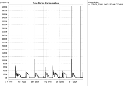
Figure 4.12. Concentrations of prosulfocarb in the sandy pond (µg/m³ = ng/l).
Figur 4.12. Koncentration af prosulfocarb i det sandede vandhul (µg/m³ = ng/l).
Figure 4.13 shows more or less the oppostite situation, where drift becomes important in the dry years, but the pond receives a contribution from groundwater during the wet years. Bromoxynil has a low to medium sorption and a very high degradation rate.
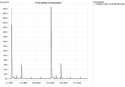
Figure 4.13. Concentrations of spring-applied bromoxynil in the sandy pond (µg/m³ = ng/l).
Figur 4.13. Konentration af forårsudbragt bromoxynil i det sandede vandhul (µg/m³ = ng/l).
Figure 4.14 and Figure 4.15 shows the pattern for two compounds with DT50-values above 50-60 days and medium sorption properties. Here the yearly spraying leads to a buildup in the groundwater concentrations, which then dominates the pattern in the pond.
Figure 4.14. Concentrations of propiconazol in the sandy pond.
Figur 4.14. Koncentration af propiconzol i det sandede vandhul.
Figure 4.15. Concentrations of terbutylazin in the sandy pond (µg/m³ = ng/l).
Figur 4.15. Koncentration af terbutylazin i det sandede vandhul(µg/m³ = ng/l).
As indicated in Table 4.6, only four of the 14 sandy pond-scenarios were significantly influenced by the change in code. A change in assumptions regarding wind drift will thus only influence the concentration level for some of the pesticides included in the simulations.
The PestSurf templates extract data in the center point of the three pond nodes, which is also used for the above presentations. There is thus no diffence between the concentrations generated. Examples of result presentations using the template are shown in Figure 4.16 and Table 4.12.
Click here to see Figure 4.16.
Figure 4.16. Example of result presentation overview by the PestSurf template for prosulfocarb the sandy pond. The lowest detection value is set to 1 ng/l.
Figur 4.16. Eksempel på resultatoversigt præsenteret i PestSurf-skabelonen for prosulfocarb i det sandede vandhul. Detektionsgrænsen er sat til 1 ng/l.
Table 4.12. Example of tables produced by the PestSurf Excel Template, applied to prosulfocarb. The detection value used for generation of the table is 1 ng/l. The toxicity values were set to 10, 100 and 1000 ng/l, respectively. The recorded peaks are shown in Figure 4.16.
Tabel 4.12. Uddrag fra resultatoversigt genereret af PestSurf-Excelskabelonen for prosulfocarb. Grænseværdierne anvendt i tabelgenereringen er detektionsgrænsen = 10 ng/l, toxicitet overfor fisk, daphnier og alger er sat til hendholdsvis 10, 100 og 1000 ng/l. De beskrevne koncentrationstoppe er vist i Figur 4.16.
4.4.3 Sandy loam catchment, stream
The pattern found in the sandy loam stream was strongly affected by the change in code. Because the assumption concerning the present drift calculation may cause unrealistically high concentrations, conclusions from both the first and the second set of simulations will be highlighted.
The sandy loam catchment is complicated by the fact that the maximum concentration occurs in different places and are due to different local conditions from simulation to simulation. It is therefore somewhat difficult to derive simple patterns. However, in the second set of simulations, where drift dominates most of the runs, the pattern simplifies somewhat. The sites for the global maximum and local maxima are indicated in Table 4.13- Table 4.15.
It is clear from the tables that NedreLillebaek 1279 produces the maximum concentrations when the simulations are drift dominated. In the first set of simulations, no maximum concentrations were generated in this point. NedreLillebaek 847 generates the maximum values for pendimethalin, which is dominated by a groundwater contribution. In the first set of simulations, this point generated the maximum value for six of the simulations, typically the ones influenced by groundwater. Fluazinam generates its maximum value in a tributary (Steensbaek 412.5) in both simulations. The value is due to a drainage event. The highest value for fluazinam in the main stream system is generated in UpperLillebaek 437.5 in both sets of simulations.
Other points that generated maxima in the main stream system due to drainage events were UpperLillebaek 125 (spring application of bromoxynil), UpperLillebaek 352.5 (Malathion), UpperLillebaek 625 (bentazon and rimsulfuron), and UpperLillebaek 1650 (Metamitron).
Taking into consideration that NedreLillebaek sees to be influenced by an instability and is influenced by high groundwater concentrations, it is recommended that concentrations for administrative purposes are evaluated in OvreLillebaek only.
As the dynamics of the upper and lower part of the catchment may be different, the two stretches are treated separately.
For the upper part of the catchment, the maximum concentrations may be generated by drift as shown in Figure 4.17 for malathion.
Table 4.13. General overview of the location in the sandy loam catchment, whereglobal and local maximum values occurred in the 1.st set of simulations. The global maxima are shown with bold.. If the global maximum does not occur in the main stream, the highest value in the main stream is shown with italics.
Tabel 4.13. Generel oversight over lokaliteten i morænelersoplandet, hvor globale og lokale maxima fandes i 1. simulering. maxima er vist med ”fed”. Hvis det globale maximum ikke findes i hovedvandløbet, er den højeste værdi i hovedvandløbet vist med italics.
Table 4.14. General overview of the location in the sandy loam catchment, whereglobal and local maximum values occurred in the 2nd set of simulations. The global maxima are shown with bold. If the global maximum does not occur in the main stream, the highest value in the main stream is shown with italics.
Tabel 4.14. Generel oversight over lokaliteterne i morænelersoplandet, hvor globale og locale maxima fandtes i 2. sæt simuleringer. Maxima er vist med ”fed”. Hvis det globale maximum ikke findes i hovedvandløbet, er den største værdi i hovedvandløbet vist med italics.
Table 4.15. Relative concentration levels at each of the local maxima recorded in Table 4.14.
Tabel 4.15. Relative koncentrationsniveauer for hvert lokalt maximum vist i Tabel 4.14.
Figure 4.17. Typical concentration pattern for malathion in the upstream part of the sandy loam catchment (µg/m³ = ng/l).
Figur 4.17. Typisk koncentrationsmønster for malathion i den opstrøms del af morænelersoplandet (µg/m³ = ng/l).
Malathion is characterised by a very fast breakdown rate, and the drift is therefore the only contribution visible. Somewhat similar patterns are found for metamitron (Figure 4.18) and terbutylazin (Figure 4.19). In the last two cases, however, drainage contributions are visible due to either the 20-year event or rainfall events occurring after spraying.
Figure 4.18. Typical concentration pattern for metamitron in the upstream end of the sandy loam catchment (µg/m³ = ng/l).
Figur 4.18. Typisk koncentrationsmønster for metamitron i den opstrøms del af morænelersoplandet (µg/m³ = ng/l).
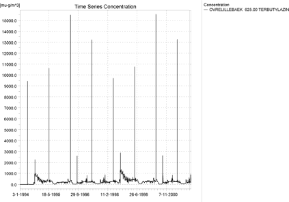
Figure 4.19. Concentration pattern for terbutazin in the upstream end of the sandy loam catchment (µg/m³ = ng/l).
Figur 4.19. Typisk koncentrationsmønster for terbutylazin i den opstrøms del af morænelersoplandet (µg/m³ = ng/l).
Figure 4.20 shows a drainage dominated time series from the upper part of the catchment for fluazinam. It is dominated by the extreme weather conditions generating a single large drainage event. In the first set of simulations, prosulfocarb and bromoxynil generated drainage events that were not influenced by the extreme event in September (as they are applied after the event or break down before the event).
Figure 4.20. Concentration pattern for Fluazinam in the upstream part of the sandy loam catchment (µg/m³ = ng/l).
Figur 4.20. Typisk koncentrationsmønster for Fluazinam i den opstrøms del af morænelersoplandet (µg/m³ = ng/l).
The pattern displayed in the lower part of the sandy loam catchment may or may not resemble the upstream pattern. For malathion (Figure 4.21), the picture is identical. However, the fact that the whole stream is sprayed at the same time with 30 minutes causes a buildup of concentrations. For alpha-cypermethrin (Figure 4.22), however, the pattern is influenced by the groundwater contribution. This is the case for all the compounds with DT50-values higher than 56 days (fluazinam, propiconazol, terbutylazin, alpha-cypermethrin and pendimethalin). These compounds also have good sorption properties – they seem to enter the groundwater during strong leaching events and wash out over a long time.
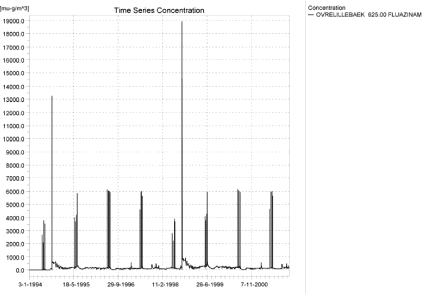
Figure 4.21. Concentration pattern for malathion in the downstream part of the sandy loam catchment (µg/m³ = ng/l).
Figur 4.21. koncentrationsmønster for malathion i den nedstrøms del af morænelersoplandet (µg/m³ = ng/l).
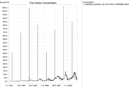
Figure 4.22. Typical concentration pattern for alpha cypermethrin in the downstream part of the sandy loam catchment. The wind drift events still dominates and the 20-year event does not result in particularly high concentrations (µg/m³ = ng/l).
Figur 4.22. Typisk koncentrationsmønster for alpha-cypermethrin i den nedstrøms del af morænelersoplandet. Vinddriften dominerer og 20-års-hændelsen resulterer ikke i specielt store koncentrationer (µg/m³ = ng/l).
Bromoxynil more or less follows the pattern of malathion – the DT50 value of 0.54 days does not lead to a buildup over time, and the 20-year event is not relevant in this case. The minimal drainage events that occur are due to rainfall occurring soon after spraying. The pattern for autumn-applied bromoxynil is almost identical to the pattern of prosulfocarb (Figure 4.23), which, however, show a higher degree of drainage contribution.
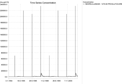
Figure 4.23. Concentration pattern for prosulfocarb in the downstream part of the sandy loam catchment (µg/m³ = ng/l).
Figur 4.23. koncentrationsmønster for prosulfocarb i den nedstrøms del af morænelersoplandet (µg/m³ = ng/l).
Figure 4.24 shows the pattern of groundwater contribution for pendimetalin. The groundwater has received a large contribution during the wet period and washes out over time. For the autumn-application, the high concentrations due to drift and groundwater co-incides. The concentration levels are unrealistically high. Bentazon (Figure 4.25) shows no buildup, and the pattern in the downstream end is identical to the pattern further upstream. However, the 20-year drainage event is visible.
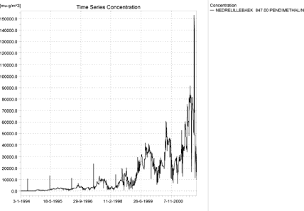
a)
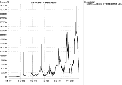
b)
Figure 4.24. Concentration pattern for spring (a)- and autumn (b)-applied pendimetahalin in the downstream part of the sandy loam catchment (µg/m³ = ng/l).
Figur 4.24. koncentrationsmønster for (a) forårsudbragt og (B) efterårsudbragt pedimethalin i den nedstrøms del af morænelersoplandet (µg/m³ = ng/l).
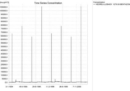
Figure 4.25. Concentration pattern for bentazon in the downstream part of the sandy loam catchment (µg/m³ = ng/l).
Figur 4.25. koncentrationsmønster for bentazon i den nedstrøms del af morænelersoplandet (µg/m³ = ng/l).
Figure 4.26 - Figure 4.28 show longitudinal profiles of typical events. Figure 4.26 represents a pure drift event. Tributaries, buffer zones and dilution influence the somewhat rugged picture of maximum concentrations.
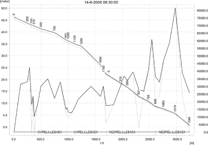
Figure 4.26. Concentrations of malathion in the sandy loam catchment on 14. June-2000, 8:30. The concentrations are generated by wind drift (µg/m³ = ng/l).
Figur 4.26. Koncentrationer af malathion i morænelersoplandet den 14. juni 2000, 8.30. Koncentrationerne er genereret af vinddrift (µg/m³ = ng/l).
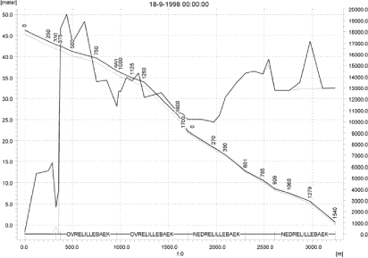
Figure 4.27. Concentrations of fluazinam in the sandy loam catchment on 18. September-1998. The concentrations are generated by a rainfall event over two days with a return period of 1 in 20 years (µg/m³ = ng/l).
Figur 4.27. Koncentrationer af fluazinam I morænelersoplandet den 18. september 1998. Koncentrationen genereres af en nedbørshændelse over to dage med en hyppighed på 1 i 20 år (µg/m³ = ng/l).
Figure 4.27 shows the sandy loam catchment during the 20-year event fluazinam. The upper part of the catchment does not reach its maximum values at this time, but a considerable part of the catchment does.
Figure 4.28 shows the pattern occurring due to groundwater influence. Only the lower part of the catchment receives a groundwater contribution, and the highest concentrations are reached just after a dry summer, when the flow only consists of groundwater.
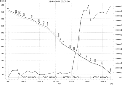
Figure 4.28. Concentrations of pendimethalin in the sandy loam catchment on 22. November 2001. The concentrations are dominated by the baseflow contribution to the drains just after a dry summer (µg/m³ = ng/l).
Figur 4.28. KOncentrationer af pendimethalin i morænelersoplandet den 22. november 2001. Koncentrationerne domineres af grundvandstilførslen til dræn lige efter en tør sommer (µg/m³ = ng/l).
A comparison of global maximum concentrations and the concentrations generated by the pre-defined locations in the PestSurf result templates is shown in Table 4.16. For the sandy loam stream, the maximum concentration was caught by the template in most cases, particularly when the cause was wind drift. Generally, the points were not caught when drainage and groundwater was the source of the maximum concentration.
Table 4.16. The maximum values generated by PestSurf, extracted by the extraction template and the maximum value reached in the main stream if different from the global max.
Tabel 4.16. Maximumværdier genereret i PestSurf, extraheret af resultatpræsentations-skabelonerne og maximumværdien i hovedvandløbet hvis det afviger fra det globale maximum.
| Sandy loam catchment | |||
| Compound Name | Global max µg/l |
template max µg/l |
max in main stream µg/l |
| Alpha-cypermetrin | 1.355 | 1.355 | |
| Bentazon | 105.741 | 105.741 | |
| Bromoxinil – april | 6.000 | 6.000 | |
| Bromoxinil – oktober | 17.805 | 17.805 | |
| Fluazinam | 26.398 | 19.551 | 19.551 |
| Malathion | 81.412 | 81.412 | |
| Metamitron | 44.935 | 44.935 | |
| Pendimenthalin hvede | 337.048 | 322.974 | |
| Pendimenthalin vaarbyg | 152.970 | 137.541 | |
| Propiconazol | 11.786 | 11.786 | |
| Prosulfocarb | 234.524 | 234.524 | |
| Rimusulfuron | 2.348 | 2.348 | |
| Terbuthylazin | 32.148 | 32.148 | |
| Tribenuron | 0.747 | 0.747 | |
Figure 4.29-Figure 4.32 and Table 4.17 - Table 4.20 show the output of the PestSurf result presentation templates based on pre-defined locations. The general principle is as described in 4.3.1. The tabulated results for fluazinam (Table 4.19 and Table 4.20) shows that the 80’es percentile of the concentration peaks is about 5 % of the maximum value for the upstream part of the catchment, and even the 95’th percentile is about 6 times lower than the maximum value. The differences are less pronounced for the lower part of the catchment. This illustrates the effect of the extreme event on the maximum concentrations generated. For the events where the 8 drift events dominate the picture, the maximum value and the 80’th percentile tend to be at the same level of magnitude.
Click here to see Figure 4.29.
Figure 4.29. Example of result presentation overview by the PestSurf template for fluazinam in the upper part of the sandy loam catchment. The lowest detection value was set to 100 ng/l.
Figur 4.29. Eksempel på resultatoversigt præsenteret i PestSurf-skabelonen for Fluazinam i den opstrøms del af moræneoplandet. Detektionsgrænsen er sat til 100 ng/l.
Click here to see Figure 4.30.
Figure 4.30. Example of result presentation overview by the PestSurf template forfluazinam in the lower part of the sandy loam catchment. The lowest detection value was set to 2000 ng/l.
Figur 4.30. Eksempel på resultatoversigt præsenteret i PestSurf-skabelonen for Fluazinam i den nedstrøms del af moræneoplandet. Detektionsgrænsen er sat til 2000 ng/l.
Click here to see Figure 4.31.
Figure 4.31. Example of result presentation overview by the PestSurf template for bentazon the upper part of the sandy loam catchment. The lowest detection concentration was set to 150 ng/l.
Figur 4.31. Eksempel på resultatoversigt præsenteret i PestSurf-skabelonen for Bentazon i den opstrøms del af moræneoplandet. Detektionsgrænsen er sat til 150 ng/l.
Click here to see Figure 4.32.
Figure 4.32. Example of result presentation overview by the PestSurf template for bentazon the lower part of the sandy loam catchment. The lowest detection concentration was set to 150 ng/l.
Figur 4.32. Eksempel på resultatoversigt præsenteret i PestSurf-skabelonen for bentazon i den nedstrøms del af moræneoplandet. Detektionsgrænsen er sat til 150 ng/l.
Table 4.17. Part of the result sheet generated by the PestSurf Excel sheet for the upstream part of the sandy loam catchment for fluazinam. The detection value used ofr generation of the table = 100 ng/l. The toxicity values for fish, daphnies and algae were set to 1000, 10000 and 10000 ng/l, respectively. The recorded peaks are shown in Figure 4.29.
Tabel 4.17. Uddrag fra resultatoversigt genereret af PestSurf-Excelskabelonen for den opstrøms del af morænelersoplandet for fluazinam. Grænseværdierne anvendt i tabelgenereringen er detektionsgrænsen = 100 ng/l, toxicitet overfor fisk, daphnier og alger er sat til hendholdsvis 1000, 10000 og 10000 ng/l. De beskrevne koncentrationstoppe er vist i Figur 4.29.
Table 4.18. Part of the result sheet generated by the PestSurf Excel sheet for the downstream part of the sandy loam catchment for fluazinam. The detection value used for generation of the table = 2000 ng/l. The toxicity values for fish, daphnies and algae were set to 5000, 10000 and 10000, respectively. The recorded peaks are shown in Figure 4.30.
Tabel 4.18. Uddrag fra resultatoversigt genereret af PestSurf-Excelskabelonen for den nedstrøms del af morænelersoplandet for fluazinam. Grænseværdierne anvendt i tabelgenereringen er detektionsgrænsen = 2000 ng/l, toxicitet overfor fisk, daphnier og alger er sat til hendholdsvis 5000, 10000 og 10000 ng/l. De beskrevne koncentrationstoppe er vist i Figur 4.30.
Table 4.19. Example of tables produced by the PestSurf template for bentazon for the upstream part of the sandy loam catchment. The limiting values applied in the Table generation is lowest detection value = 150 ng/l, toxicity to fish, daphnies and algae are set to 1000, 5000 and 10000 ng/, respectively. The recorded peaks are shown in Figure 4.31.
Tabel 4.19. Uddrag fra resultatoversigt genereret af PestSurf-Excelskabelonen for bentazon for den opstrøms ende af morænelersoplandet. Grænseværdierne anvendt i tabelgenereringen er detektionsgrænsen = 150 ng/l, toxicitet overfor fisk, daphnier og alger er sat til hendholdsvis 1000, 5000 og 10000 ng/l. De beskrevne koncentrationstoppe er vist i Figur 4.31.
Table 4.20. Example of tables produced by the PestSurf template for bentazon for the downstream part of the sandy loam catchment. The limiting values applied For generation of the table is lowest detection value = 150 ng/l, toxicity to fish, daphnies and algae are set to 1000, 5000 and 10000 ng/, respectively. The recorded peaks are shown in Figure 4.32.
Tabel 4.20. Uddrag fra resultatoversigt genereret af PestSurf-Excelskabelonen for bentazon for den nedstrøms del af morænelersoplandet. Grænseværdierne anvendt i tabelgenereringen er detektionsgrænsen = 150 ng/l, toxicitet overfor fisk, daphnier og alger er sat til hendholdsvis 1000, 5000 og 10000 ng/l. De beskrevne koncentrationstoppe er vist i Figur 4.32.
In one case (fluazinam), the highest concentration is generated in a tributary. For the first set of simulations, where drift was less important, this was the case for six of the sandy loam stream simulations. The tributaries do not receive drift – in reality they are put into pipes, but here they are simulated as ditches. However, the tributaries require a further study to evaluate whether concentrations in the tributaries are relevant for the overall evaluation of toxicity.
First of all, the general water levels in the tributaries identified is analysed. It is clear from Figure 4.33- Figure 4.37 that the stretches Steensbaek 0, Steensbaek 125, Albjergbaek and the first 600 m of Fredligbaek are dry or almost dry during the summer. The location of the tributaries can be seen in Figure 2.1.
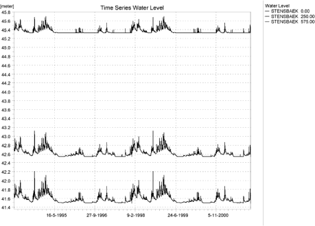
Figure 4.33. Water level in Steensbaek at point 0.00, 250 and 575, respectively.
Figur 4.33. Vandniveau i Steensbæk ved henholdsvis lokalitet 0.00, 250 og 575.
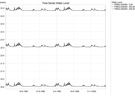
Figure 4.34. Water level in Fredligbaek at point 0.00, 200 and 400, respectively.
Figur 4.34. Vandniveau i Frediligbæk ved henholdsvis lokalitet 0.00, 200 og 400.
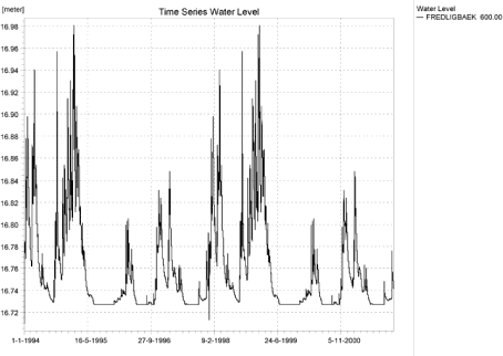
Figure 4.35. Water level in in Fredligbaek 600 m from the upstream end.
Figur 4.35. Vandniveau i Fredligbæk 600 m fra denopstrøms ende.
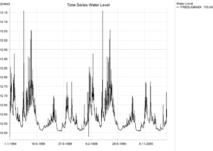
Figure 4.36. Water level in Fredligbaek, 735 m from the upstream end.
Figur 4.36. Vandniveau i Fredligbæk 735 m .fra den opstrøms ende.
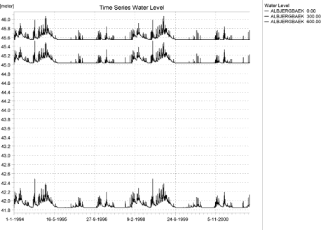
Figure 4.37. Water level in Albjergbaek at 0.00, 300 and 600 m, respectively.
Figur 4.37. Vandniveau i Aalbjergbæk ved henholdsvis lokalitet 0.00, 300 og 600.
At the most, the most downstream locations in Steensbaek and Fredligbaek can be said to have an almost continuous flow. Upstream of these points, toxicity values for fish would be of no interest here and most aquatic life would be stressed by the general living conditions in these tributaries.
A similar analysis of the main stream (Figure 4.38) shows that points upstream of and including“375 m” also run dry during the summer. “500” m is the first calculation point that does not show obvious drying. Thus, if the results are to be evaluated for a system that resembles a permanent stream, use of the results from the main stream upstream of at least 500 m is not recommended.
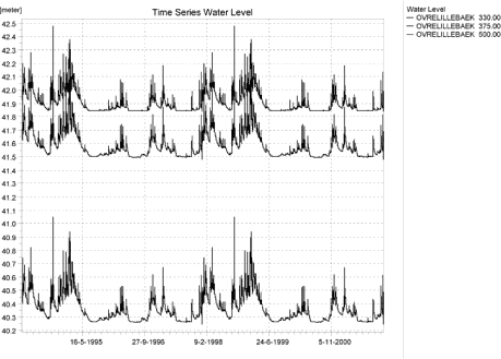
Figure 4.38. Water levels in the upstream end of OvreLillebaek, 330, 375 and 500 m from the upstream end.
Figur 4.38. Vandniveau i den opstrøms ende af OvreLillebaek ved henholdsvis lokalitet 330, 375 og 500.
Figure 4.39 and Figure 4.40 illustrates two of the cases where the highest concentrations were generated by drainage in tributaries in the first set of runs. The maximum concentrations are generated by sudden drainflow, in the first case during water level of 10 cm and a flow of 0.8 l/s, and in the second case a water level of 3 cm and a flow of about 0.4 l/s. The tributaries more or less act as an extended drain. Similarly, the maximum values generated on Figure 4.43 and Figure 4.44 coincide with water levels of 4 and 10 cm, respectively.
The same drainage concentrations are, of course, generated in the second set of simulations, but are no longer maximum values due to the increase in drift in the second set of simulations.
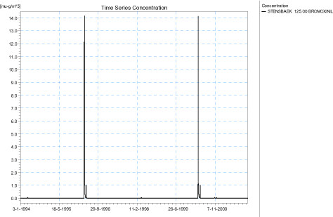
Figure 4.39. Maximum Drainage concentrations generated for spring applied bromoxynil at Steensbaek 125, 1 set of simulations (µg/m³ = ng/l).
Figur 4.39. Maximum drænkoncentration genereret for forårstilført bromoxynil i steensbaek 125 (µg/m³ = ng/l).
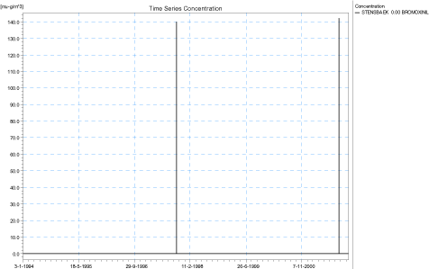
Figure 4.40. Maximum Drainage concentrations generated for autumn-applied bromoxynil at Steensbaek 0., 1 set of simulations (µg/m³ = ng/l).
Figur 4.40. Maximum drænkoncentration genereret for forårstilført bromoxynil i steensbaek 125 (µg/m³ = ng/l).
Figure 4.41 and Figure 4.42 show two cases where high drainage concentrations are generated in a tributary by the extreme event. During this event, water levels are high, 26 and 19 cm, respectively. However, as shown in the earlier figures, the tributaries are often drying out at these points. The fluazinam-concentration in Figure 4.41 is the maximum concentration generated in the whole catchment, also after the change in model code.
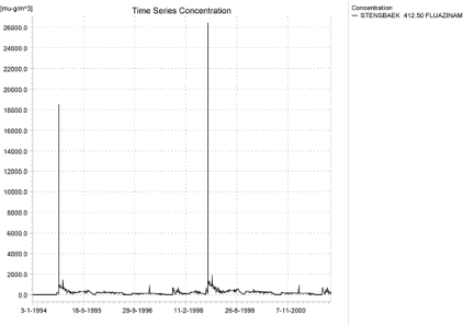
Figure 4.41. Maximum concentration (drainage and in total for the catchment) generated for fluazinam at Steensbaek 412.5 in the 1st set of simulations (µg/m³ = ng/l).
Figur 4.41. Maximum concentration (drænvand og totalt for oplandet) genereret for fluazinam I steensbæk 412.5 i 1. sæt simuleringer (µg/m³ = ng/l).
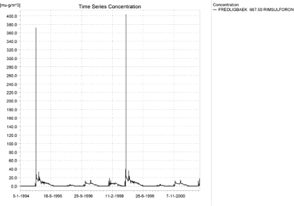
Figure 4.42. Maximum drainage concentrations generated for rimsulfuron at Fredligbaek 667.5 in the 1st set of simulations (µg/m³ = ng/l).
Figur 4.42. Maximum drænvandsconcentration genereret for Rimsulfuron i Fredligbæk 667.5 i 1. sæt simuleringer (µg/m³ = ng/l).
Figure 4.43 and Figure 4.44 show high drainage concentrations in tributaries just after a dry period.
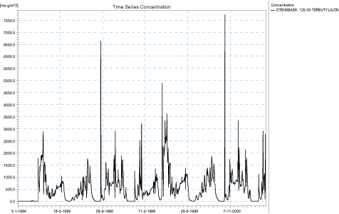
Figure 4.43. Maximum drainage concentrations generated for terbutylazin at Steensbaek 125 in the first set of simulations.
Figur 4.43. Maximum drainage concentration genereret for terbutylazin in steensbæk 125 i 1. sæt simuleringer.
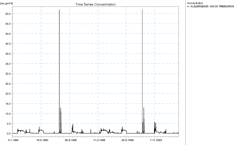
Figure 4.44. Maximum drainage concentrations generated for tribenuron methyl at Albjergbaek 450 in the 1st set of simulations (µg/m³ = ng/l).
Figur 4.44. Maximum drainage concentration(genereret for Tribenuron methyl i Aalbjergbæk 450 i 1. sæt simuleringer (µg/m³ = ng/l).
4.4.4 Sandy loam catchment, pond
The sandy loam pond is often dominated by drift events. Figure 4.45 shows an example of drift contributions to the sandy loam pond. However, the pond also receives drainage water and may in very wet periods have some interaction with groundwater. Figure 4.46 and Figure 4.47 shows the pattern obtained with propiconazol and fluazinam, where drainage contributes to the general concentration level in the pond, but the drift contribution is still visible and important.
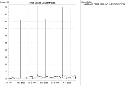
Figure 4.45. Concentrations of alpha-cypermethrin for the sandy loam pond (µg/m³ = ng/l).
Figur 4.45. Koncentrationer af alpha-cypermethrin i morænelersvandhullet (µg/m³ = ng/l).
Figure 4.46. Concentrations of propiconazol for the sandy loam pond (µg/m³ = ng/l).
Figur 4.46. Koncentrationer af Propiconazol i morænelersvandhullet (µg/m³ = ng/l).
Figure 4.47. Concentrations of fluazinam for the sandy loam pond (µg/m³ = ng/l).
Figur 4.47. Koncentrationer af fluazinam i morænelersvandhullet (µg/m³ = ng/l).
Figure 4.48 shows the situation where the drainage contribution totally dominates the picture. There is no clear distinction of when a compound displays which pattern. In Figure 4.49, the patterns obtained are compared to Koc and DT50-values of the compounds. Generally, higher sorption values increases the probability that drift is most important because sorption increase retention in the soil and decrease the leached concentrations, but when DT50 is high, the importance of drainage increases, because most of the the solute leaches over time. However, time of application is of importance too.
Figure 4.48. Concentrations of bentazon for the sandy loam pond (µg/m³ = ng/l).
Figur 4.48. Koncentrationer af bentazon i morænelersvandhullet (µg/m³ = ng/l).
Figure 4.49. Comparison of the patterns of contribution to the sandy loam pond, Koc and DT50.
Figur 4.49. Sammenligning af mønstre for tilførsel til morænelersvandhullet og Koc og DT50.
Figure 4.50 and Table 4.21 shows the PestSurf presentation tool applied to the sandy loam pond simulation for fluazinam.
Click here to see Figure 4.50.
Figure 4.50. Example of result presentation overview by the PestSurf template for fluazinam in the sandy loam pond. The lowest detection value was swt to 75 ng/l.
Figur 4.50. Eksempel på resultatoversigt præsenteret i PestSurf-skabelonen for fluazinam i morænelersvandhullet. Detektionsgrænsen er sat til 75 ng/l.
Table 4.21. Example of tables produced by the PestSurf template for fluazinam For the sandy loam pond. The detection value used for table generation is set t 10 ng/l. The toxicity values for fish, daphnies and algae were set to 15, 20 and 25 ng/l, respectively.The recorded peaks are shown in Figure 4.50.
Tabel 4.21. Uddrag fra resultatoversigt genereret af PestSurf-Excelskabelonen for Flazinam i morænelersvandhullet. Grænseværdierne anvendt i tabelgenereringen er detektionsgrænsen = 10 ng/l, toxicitet overfor fisk, daphnier og alger er sat til hendholdsvis 15, 20 og 25 ng/l. De beskrevne koncentrationstoppe er vist iFigur 4.50.
4.5 Distribution of the contribution to groundwater
An attempt was made to evaluate and compare concentrations moving to surface water and to groundwater. The pre-specified storage frequencies and setup made it more difficult than anticipated, so rather than a detailed calculation, that would have involved an extraction of time series for every point in the model, a set of examples are made to show that the concentrations in drainage water and water moving to groundwater may differ.
First of all a water balance for the whole catchment was established for the water simulations with winter wheat and spring barley. The total flow from drains to river for the sandy loam catchment was summarised, and so was the total flow moving across from the upper saturated layer (which also generates drainflow) to the second saturated layer.
For 12 randomly selected locations (out of 1849 possible locations, excluding boundary cells) spread over the catchment, the concentration time series stored every 90 days only) were extracted for the upper saturated layer. The average flow components were then multiplied with the concentration to estimate the total transport. The average concentration in drain water was then established for the whole simulation period and for the last four years of the simulation period. The calculation was carried out for spring and autumn-applied pendimethalin and bromoxynil as well as for bentazon and propiconazol.
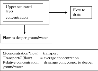
Figure 4.51. Key elements in the calculation of transport to drains and groundwater.
Figur 4.51. Nøgleelementer i beregningen af transport til dræn og grundvand.
The calculation is very rough due to the thickness of the calculation layer (typically about 3 m) and the storage frequency (90 days). It is likely that a calculation based on finer time steps would have given a greater distinction between concentrations in drainflow and flow to groundwater. The calculation does not at all take into account any additional degradation that may happen as the water level falls below drainage depth.
Figure 4.52 shows the flow components as they occur over four years. During very wet periods, the majority of the recharge to groundwater moves to the drains. In normal or dry years, the distribution is about half-half. For pesticides that mainly leach during periods dominated by drainage flow, the average concentration in drains could be expected to be higher than the average concentration moving to groundwater.
The concentration results are shown in Table 4.22. For pendimethalin, except for a single point, where the concentrations are very low, all calculation points show that higher average concentrations move to drains than to groundwater. The difference for pendimethalin is up to 40-50 %.
Pendimethalin sorbs strongly, but pesticide seems to move to the top of the saturated zone during the two wet years (year 5-6) in the second part of the simulation (Figure 4.53). Probably due to the sorption, the compound leaves the soil slowly, showing “tailing” over several years.
Bromoxynil, however, does not show the same picture. Concentrations in the groundwater are very low, and because bromoxynil breaks down very fast, the peaks arriving in groundwater are not caused by the general flow pattern but localised events taking place just after spraying (Figure 4.54 and Figure 4.55).
For spring-applied bentazon, the average relative concentration in drain is slightly higher than 1, while for the autumn-applied propiconazol, the concentration in drains is considerably higher for some points. In average, the concentration of propiconazol to drains is about 25 % higher than to groundwater.
The conclusion must be that very shortlived compounds do not follow the general flow pattern, but the more sorbing and long-lived compounds appear to generate higher average concentrations to drains than to groundwater – based on the flow patterns alone. In this rough estimate, the differences are relatively small. It is likely that finer storage steps and finer vertical discretisation would generate larger differences between concentrations in drainflow and water moving to deeper layers.
Any breakdown, filtering or sorption processes below drain depth would increase the difference between the two components further.
Click here to see Figure 4.52.
Figure 4.52. Comparison of flow components over four years of simulation. The period is repeated twice during the 8 years simulation.The wet period in the first two years of the simulation is followed by a dry and a normal year. Note that the total infiltration to groundwater (recharge) and the flow from the first to the second groundwater layer (recharge to layer 2) are indicated as negative while the drain flow is indicated as positive. Each point represents 30 days.
Figur 4.52. Sammenligning af strømningskomponenter over fire års simulering. Perioden er gentaget i 8-års-simuleringen. Den våde periode i de første to år af simuleringen følges af et tørt og et normalt år. Bemærk at den totale infiltration til grundvand (recharge) og strømningen fra første til andet grundvandsniveau (recharge to layer 2) er givet som negative mens drænflow er vist positivt. Hvert punkt repræsenterer 30 dage.
Table 4.22. Relative average concentration level (drain water/ groundwater) derived through a simple calculation based on flow patterns.
Tabel 4.22. Relativ gennemsnitskoncentration (drænvand/grundvand) på basis af en simpel beregning på grundlag af strømningsmønstre.
Click here to see Figure 4.53.
Figure 4.53 Comparison between flow components (groundwater to drain and groundwater to deeper groundwater) and concentration level in groundwater in a single point for the autumn-applied pendimethalin. Most pendimethalin reaches groundwater during a very wet period.
Figur 4.53. Sammenligning mellem strømningskomponenter (grundvand til dræn og grundvand til dybere grundvand) og koncentrationsniveauer i grundvand i et enkelt punkt for efterårsudbragt pendimethalin. Størstedelen af pendimethalinen når grundvandet i en meget våd periode.
Click here to see Figure 4.54.
Figure 4.54. Comparison between the flow components and the concentration levels in two points for the spring-applied bromoxynil. Due to the fast breakdown of bromoxynil, the presence of bromoxynil in the groundwater is due to the conditions just after spraying and not to the general groundwater recharge pattern. For both points, the highest concentration occurs during summer.
Figur 4.54. Sammenligning mellem strømningskomponenter og koncentrationsniveau i to punkter for forårsudbragt bromoxynil. På grund af hurtig nedbrydning af bromoxynil skyldes tilstedeværelsen af bromoxynil i grundvand forholdene lige efter udsprøjtning og ikke det generelle grundvands-tilstrømningsbillede. For begge punkter findes den højeste koncentration om sommeren.
Click here to see Figure 4.55.
Figure 4.55. Comparison between the flow components and the concentration levels in two points for the autumn-applied bromoxynil. Leaching is very localised in time and is caused by the conditions just after spraying rather than the general groundwater recharge pattern. Concentrations are very small.
Figur 4.55. Sammenligning mellem strømningskomponenter og koncentrationsniveau I to punkter for efterårsudbragt bromoxynil. Udvaskning er meget lokaliseret i tid og syldes forholdene lige efter udsprøjtning snarere end det generelle grundvandstilstrømningsmønster. Koncentrationerne er meget små.
Click here to see Figure 4.56.
Figure 4.56. Comparison between the flow components and the concentration levels in three points for the spring-applied bentazon. The three concentration curves show a maximum during the drainage period of the winter 1998-1999.
Figur 4.56. Sammenligning mellem strømningskomponenter og koncentrationsniveau I tre punkter for forårsudbragt bentazon. De tre koncentrationskurver viser et maximum i drænperioden i vinteren 1998-99.
Click here to see Figure 4.57.
Figure 4.57. Comparison between the flow components and the concentration levels in three points for the autumn-applied propiconazol. In this case there is a clear link between high concentrations moving to the groundwater and considerable recharge to groundwater.
Figur 4.57. Sammenligning mellem strømningskomponenter og koncentrationsniveauer i tre punkter for den efterårsudbragte propiconazol. I dette tilfælde er der en tydelig sammenhæng mellem høje koncentrationer, der bevæger sig til grundvand og væsentlig tilstrømning til grundvand.
Fodnoter
[1] The function is found in the ”Scenario”_Biomass.dfs0 file in the TIME directory made by the programme when running.
[2] The factor is crop dependent as it is the dose at 20 m compared to the dose at the edge of the stream, which depends on buffer zone with and thus the crop in question.
[3] The weight of sediment is calculated as 1m*1m*0.05 m * 800 kg/m³
Version 1.0 December 2006, © Danish Environmental Protection Agency